

Journal of Creation 20(1):81–85, April 2006
Browse our latest digital issue Subscribe
Difficulties with a Flood model for the Green River Formation
Some problems, though not insurmountable, exist with a lake model for the origin of the Green River Formation (GRF). However, critical evaluation of Oard’s Flood model shows it simply is not supported by field observations. His Flood model raises far more questions than it answers. Instead, the data clearly indicate the GRF was deposited within lakes, after the Flood.
Introduction
I want to re-emphasize that both of us are young-earth creationists attempting to explain the deposits of the Green River Formation (GRF) within a Flood model. It is our hope that this forum will stimulate others to dig deeper and ‘think outside the box’ as we consider what parts of the geologic record represent the Flood. Due to space limitations, I cannot fully evaluate Oard’s Flood model. However, I will attempt to do two things. First, Oard has raised some good points that, at the outset, appear not to be easily answered by a lake model. I will try to summarize those arguments (in italics, below) and give some possible solutions. Second, I will list what I see are the most serious difficulties of the Flood model that Oard has proposed.
Supposed difficulties with my lake model
- The GRF lakes do not have ideal bull’s-eye patterns of sedimentation. Lake Uinta is really the only exception to this general rule and for good reasons.1 The pattern of coarse to fine is still present, but in a linear pattern instead of the circular ‘bull’s-eye’ pattern. The bull’s-eye pattern is a general pattern can be altered by many factors including lake geometry, surrounding topography (is the lake edge up against a mountain range or a flat plain), prevailing wind direction, wave activity, fluctuations in water level, stream confluences, etc. All of the GRF basins have the expected coarse to fine pattern, moving from basin edge to basin centre.
-

Figure 37. The Eocene Pass Peak Formation is interpreted to be an alluvial fan and plain gravels that interfinger with the Wasatch Formation, which in turn, interfinger with the fine grained sediments of the Greater Green River Basin, to the south.9 This photo was taken near Hoback Jct., Wyoming. (click for larger image)
* Figures are numbered continuously through all the articles in this forum. - Dolomite and ‘evaporite’ minerals are difficult to explain within a lake model. Hot water is not the only mechanism for dolomite formation. There are some new avenues of research regarding dolomite formation, which are very plausible for Flood and post-Flood settings.2–5 The reason that the GRF basins have suites of unique minerals is because they were geochemically unique from each other! As was argued earlier, the suite of minerals found in the Greater Green River basin cannot come from anything that even closely resembles the ionic composition of seawater, as must be Oard’s model. The chemistry completely precludes the possibility!6 With that said, I am not completely sure the ‘evaporite’ minerals are true evaporites. More research is needed in this area.
- There is a lack of shoreline benches and beach gravels around the GRF lakes. I am not aware of any wave cut benches in the GRF basins as occur in places like ancient Lake Bonneville. However, we might not expect them because of shallow gradients found in the basins.7 There are shoreline gravels and I have seen rounded, flattened igneous and metamorphic gravels on the north-east side of Fossil Basin (just north of U.S. Hwy 30). They occur on the immediate margin of Fossil Basin and likely represent former shoreline gravels. Rounded and flattened gravels are characteristic of shorelines.8.
- Alluvial fans do not enter into the lakes. Alluvial fans would be expected in areas where steep topography intersected with the basins. Indeed, the Eocene Pass Peak Formation (figure 37*) interfingers with the sediments of the Wasatch Formation in northern Green River Basin and has been interpreted as alluvial fan gravels.9 Alluvial fans also occur in the southern-most part of the Greater Green River Basin as part of the Wasatch Formation, up against the Uinta mountains.10 Where topography was not as steep, entering streams would be expected to make delta deposits, of which many occur and were previously discussed (figure 15). Many of the shorelines of the GRF lakes appear to have been on relatively flat plains. Alluvial fans are not expected in these cases.
- The paleontology of the GRF is different from the post-Flood ice-age lakes. I believe this is really not an important factor. Differences in climate, latitude, geography, altitude and time since the Flood might easily explain the differences.
- The geomorphology of the GRF cannot be explained in a post-Flood model. This is perhaps Oard’s best argument; however, as discussed previously, his pediment formation model fails for the GRF. Oard has only explored the geomorphology on the GRF in terms of erosion caused during the recessional stage of the Flood. Possible post-Flood formation of features such as water gaps and pediments in this region needs to be further explored.

Difficulties with Oard’s Flood model
-

Figure 38. A large overturned stromatolite head found in a cross-bedded channel. The channel is not shown in this picture, but was clearly evident in the larger outcrop. The stromatolite head is about 80 cm in diameter. Southern Washakie Basin (figure 1), Delany Rim, Wyoming. Overturned stromatolite heads in the GRF have also been seen by the author in Douglass Pass, Colorado. (click for larger image)
- The circulating eddy model utterly fails to explain the sedimentology and paleontology. As was discussed previously, the basins have a general bull’s-eye pattern of sediments. Coarse deposits of material entering into the basins (interpreted to be river deposits), display current patterns directed toward basin centres.13–15 Fish fossils are randomly oriented, except where they are associated with coarser deposits, and then they display preferred orientation.16 Although creative, the eddy model cannot explain this. If I understand the model correctly, current patterns should be directed away from the basin centres and fish should be oriented throughout the basins. All of the marginal features of the basins should show evidence of the eddy, and none is to be found. Instead we find ripples, mudcracks, nesting sites, animal tracks, caddisfly mounds, stromatolites, etc. which are completely consistent with a lake shoreline. The eddy model does not account for the observed paleontology or sedimentology and the proximity of these features to the margin of the basins.
-

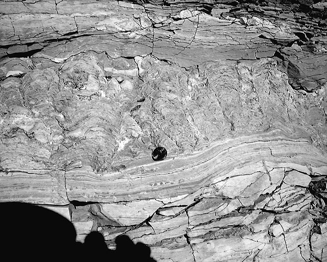
Figure 39. Stromatolite mounds in mudstone, Green River Formation, Douglas Pass, Colorado. Douglas Pass is located between the Uinta and Piceance Creek Basins (figure 1). At this location, multiple layers of large stromatolites occur with associated shallow water indicators. Note that the mud layers above must have come after the growth of the stromatolites, since they are undeformed. The coin in the centre of the picture is a U.S. penny, 1.9 cm in diameter. (click for larger image)
- Accumulation of the GRF within a matter of weeks or less, simply cannot explain the fish taphonomy. First, Oard suggests the fish were taken to the bottom by hyperpycal flows. If so, the fish should be oriented to show current direction; they are not. Orientation would be a clear result of these types of flow processes. Second, the fish taphonomy clearly indicates that some fish exploded while adhered to the bottom, before they were buried (figure 40). Gases cannot build-up in these fish until after they have died and are adhered on the bottom (otherwise they would float). Based on my experiments, it usually takes several days for gases to cause fish explosion.16 The fish cannot explode in water deeper than about 3 m because water pressure compresses the volume of the generated gas bubbles.
- The Flood model fails to explain the unique geochemistry of the GRF. In this case we can say more than the Flood was ‘complex’ or that there are ‘many problems’. The chemical evolution of brines in modern lakes is well known.19 Many lakes do have halite and gypsum deposits, but that is because they begin with brines that are far more concentrated in Ca2+ and Mg2+ than HCO3- (the Great Salt Lake in Utah, for example). In modern seawater, there are 1.27 g/kg of Mg2+ and 0.40 g/kg of Ca2+ compared to only 0.14 g/kg of HCO3.20 If lakes begin with HCO3- being far more concentrated than Ca2+ and Mg2+, then various sodium carbonates (as in the GRF) instead of gypsum and halite will be deposited.19 Oard appears to believe the GRF was deposited close to the time of maximum inundation of the Flood (day 150, according to him). By this time, most Flood water probably had minor constituents of the major ions contained in seawater today. Yet, if the GRF basins had anything close to the ionic composition (not necessarily salinity) of modern seawater, it is impossible to explain the suite of minerals found in the GRF. Oard has not shown, and I submit, cannot show, how these minerals can precipitate from the ionic composition of seawater.
-

Figure 40. This Diplomystus is preserved in the dorsal view. After the fish settled to the bottom, it appears to have exploded, ejecting elements from the right lateral gastric region. Note the scales and bones directionally scattered towards the bottom of the photo. Also note that the vertebral column was contorted towards the top of the photo as a result of the explosion towards the bottom of the photo. Additional evidence for the gastric eruption is that rib elements occur on top of scales. Scales would have been ejected away from the fish first, followed by interior elements (ribs). Gas build-up did not cause it to float because it may have adhered onto the bottom via various micro-organisms. The specimen was collected from Whitmore’s16 HCCRT site (figure 2). This quarry is on BLM property and a permit was obtained to collect it. Specimen HCCRT 6–8. Scale is in cm. (click for larger image)
- uplifts for the Mesozoic strata (which might contain dinosaur trackways, nests, etc.) stratigraphically below the GRF,21,22
- uplifts causing the formation of the GRF basins,
- apparently, further up and down tectonic adjustments to account for every stratigraphic horizon containing footprints, nests and true mud cracks within the GRF, and
- final uplift of the entire area taking it approximately 2 km above current sea level.


Conclusion and a caution
I conclude that the GRF could not have been deposited in a short time, during the Flood. In this forum, compelling evidence has been presented that the GRF is best explained as a post-Flood lake system. This conclusion was reached by evaluating the stratigraphy, sedimentology, paleontology, geochemistry, structural geology and other features of the GRF.
Many creationists may be uncomfortable with this conclusion and even find it untenable because of the ‘Eocene’ age of the GRF rocks. My approach has been to ignore the ‘age’ designation (for now) and focus on various criteria to interpret the rocks. I encourage others to do the same within the framework of Scripture. Just because I believe there is a compelling case for the Eocene GRF to be post-Flood, does not mean all ‘Eocene’ rock is post-Flood. The Flood/post-Flood boundary may be stratigraphically above or below this ‘age’ in other parts of the world. Before we, as creationists, start using ‘age’ as a criterion for determining which deposits are Flood and post-Flood, we need to understand the worldwide distribution of fossils and their apparent stratigraphic order more fully.
Extreme caution and critical analysis of criteria should be used in any paleoenvironmental analysis. Supposed lake deposits deeper in the geologic record may not be lakes at all. The GRF basins are unique from other ‘lake’ deposits because they are well preserved, well exposed at the surface, and have been thoroughly studied. The argument for a lake interpretation for the GRF is compelling because of the entire suite of characteristics present. For deposits deeper in the record, not as well exposed, and not as well known, paleoenvironmental interpretations are much less certain, no matter what perspective you have on Earth history.
References
- Picard, M.D. and High Jr, L.R., Criteria for recognizing lacustrine rocks, in Recognition of ancient sedimentary environments; in: Rigby, J.K. and Hamblin, W.K. (Eds.), Society of Economic Paleontologists and Mineralogists, Special Publication No. 16, p. 108–145, 1972. Return to text.
- Wright, D.T., The role of sulphate-reducing bacteria and cyanobacteria in dolomite formation in distal ephemeral lakes of the Coorong region, South Australia, Sedimentary Geology 126:147–157, 1999. Return to text.
- Vasconcelos, C. and McKenzie, J.A., Microbial mediation as a possible mechanism for natural dolomite formation at low temperatures, Nature 377(6546):220–222, 1995. Return to text.
- Camoin, G.F., Microbial mediation in carbonate diagenesis, Sedimentary Geology 126:1–4, 1999. Return to text.
- Roberts, J.A., Bennett, P.C., Gonzalez, L.A., Macpherson, G.L. and Milliken, K.L., Microbial precipitation of dolomite in methanogenic groundwater, Geology 32(4):277–280, 2004. Return to text.
- Bradley, W.H. and Eugster, H.P., Geochemistry and paleolimnology of the trona deposits and associated authigenic minerals of the Green River Formation of Wyoming, U.S. Geological Society Professional Paper 496-B:1–71, 1969. Return to text.
- Buchheim, H.P., Paleoenvironments, lithofacies and varves of the Fossil Butte Member of the Eocene Green River Formation, South-western Wyoming, Contributions to Geology, University of Wyoming 30(1):3–14, 1994. Return to text.
- Reineck, H.-E. and Singh, I.B., Depositional Sedimentary Environments, 2nd ed., Springer-Verlag Inc., New York, 1980. Return to text.
- Steidtmann, J.R., Origin of the Pass Peak Formation and equivalent Early Eocene strata, central western Wyoming, Geological Society of America Bulletin 82:156–176, 1971. Return to text.
- Eugster, H.P. and Hardie, L.A., Sedimentation in an ancient playa-lake complex: the Wilkins Peak Member of the Green River Formation, Geological Society of America Bulletin 86:319–334, 1975. Return to text.
- Lamond, R.E. and Tapanila, L., Embedment cavities in lacustrine stromatolites; evidence of animal interactions from Cenozoic carbonates in USA and Kenya, Palaios 18(4–5):445–453, 2003. Return to text.
- Cohen, A.S., Talbot, M.R., Awramik, S.M., Dettman, D.L. and Abell, P., Lake level and paleoenvironmental history of Lake Tanganyika, Africa, as inferred from late Holocene and modern stromatolites, Geological Society of America Bulletin 109(4):444–460, 1997. Return to text.
- Petersen, F.S., Lacustrine deltaic deposits of the Sandstone Tongue of the Wasatch Formation, Fossil Basin, Wyoming, Masters Thesis, Loma Linda University, Loma Linda, CA, 1987. Return to text.
- Roehler, H.W., Hanley, J.H. and Honey, J.G., Geology of the Cottonwood Creek Delta in the Eocene Tipton Tongue of the Green River Formation, south-east Washakie Basin, Wyoming, U.S. Geological Survey Bulletin B 1669:A1–A14, 1988. Return to text.
- Roehler, H.W., Revised Stratigraphic Nomenclature for the Wasatch and Green River Formations of Eocene Age, Wyoming, Utah and Colorado, U.S. Geological Society Professional Paper 1506-B:1–38, 1991. Return to text.
- Whitmore, J.H., Experimental Fish Taphonomy with a Comparison to Fossil Fishes, Ph.D. Dissertation, Loma Linda University, Loma Linda, CA, 2003. Return to text.
- Woolley, D.A., Fish preservation, fish coprolites and the Green River Formation, Journal of Creation 15(1):105–111, 2001. Return to text.
- Berthault, G., Experiments on lamination of sediments, resulting from a periodic graded-bedding subsequent to deposit—a contribution to the explanation of lamination of various sediments and sedimentary rocks, Journal of Creation 3:25–29, 1988. Return to text.
- Hardie, L.A., Smoot, J.P. and Eugster, H.P., Saline lakes and their deposits: a sedimentological approach, in: Matter, A. and Tucker, M.E. (Eds.), Modern and Ancient Lake Sediments, Blackwell Scientific Publications, Oxford, pp. 7–41, 1978. Return to text.
- Garrison, T., Essentials of Oceanography, 3rd ed., Brooks/Cole—Thomson Learning, Pacific Grove, CA, 2004. Return to text.
- M’Gonigle, J.W. and Dover, J.H., Geologic map of the Kemmerer 30’ x 60’ quadrangle, Lincoln, Uinta and Sweetwater Counties, Wyoming, Map I-2079, Miscellaneous Investigations Series, U.S. Geological Survey, Denver, CO, 1992. Return to text.
- Lamerson, P.R., The Fossil Basin and its relationship to the Absaroka Thrust System, Wyoming and Utah; in: Powers, R.B. (Ed.), Geologic Studies of the Cordilleran Thrust Belt, Vol. I, Rocky Mountain Association of Geologists, Denver, CO, pp. 279–340, 1982. Return to text.
Readers’ comments
Comments are automatically closed 14 days after publication.