

Journal of Creation 26(2):100–109, August 2012
Browse our latest digital issue Subscribe
Three early arguments for deep time—part 3: the ‘geognostic pile’
Of the three primary original arguments advanced for deep time in the 18th century, only one—the time needed to form the sedimentary rock record—is still advanced, even though it is a weaker argument than most think. It initially focused on the volume of the ‘Secondary’ sedimentary rocks, but grew to include a variety of sedimentary features accepted as age indicators of deep time. The argument from the volume of the sedimentary record is clearly false and many of the various ‘age indicators’ are explicable using a Genesis Flood model. Furthermore, indicators of rapid sedimentation present problems for secular geology. Since the other two primary original arguments for deep time—the time needed for valley erosion and for volcanic accumulation—are demonstrably invalid, it appears that none of the original arguments carries evidential weight. The failure of earth scientists from the 18th century to the present to objectively evaluate deep time violates evidentiary logic and strongly suggests that the empirical arguments were (and continue to be) ad hoc justifications of a belief system. Deep time is better understood as a presupposition of secular natural history, not an empirical conclusion.
Since deep time has been unquestioned since the 18th century, the arguments of that time should still be valid and compelling. If not, their failure, combined with the concomitant failure of earth scientists to ever reassess the idea of prehistory1 suggests that the concept was the product of secularist faith. Previous papers in this series have shown logical and empirical flaws in two of the three arguments for deep time, namely valley erosion2 and volcanic terranes.3
This paper focuses on the sufficiency of the third argument from the sedimentary rock record, or what was originally called the ‘geognostic pile’.4 This terminology reflects the origins of modern stratigraphy in ‘geognosy’. As noted in the earlier papers, the sciences of the earth in the 18th century were different from modern geology (figure 1). The three major disciplines included natural history, natural philosophy, and geotheory. Geognosy was the branch of natural history that described and classified the subsurface strata of the crust.
(1) Natural History. |
“description and classification of the diversity of terrestrial things” (Rudwick, ref. 2, 2005, p. 59). |
|
(a) mineralogy (b) physical geography (c) geognosy |
The collection, identification, and classification of specimens of minerals, rocks, and fossils; knowledge distributed by exact pictures. The study of the major features of Earth’s surface, primarily through fieldwork, such as mountains, rivers and volcanoes, with an emphasis on pictures and maps. The study of the structure of Earth’s crust; emphasizing cross sections to depict the third dimension and closely associated with mining. It was developed most strongly in German mining schools. |
(2) Natural Philosophy ‘earth physics’ |
The causal explanation via natural laws of terrestrial phenomena described by the sub-disciplines of natural history, and consciously distinct from the description and classification of those endeavors. |
(3) Geotheory ‘Theory of the Earth’ |
A high-level theory or system of Earth as a whole, derived from unifying the causal explanations of earth physics into a coherent whole. The goal was to discover the one overarching cause of Earth’s phenomena, just as Newton had done for the cosmos with gravity. |
Figure 1. Sciences of the earth during the eighteenth century as described by Rudwick. Note the absence of familiar boundaries between geology, biology, physics, and chemistry, which were not recognized at the time. (From Reed and Klevberg, ref. 5.)
The argument from the geognostic pile
What was geognosy?
Geognosy was the Anglicized version of the German geognosie, or ‘earth knowledge’. It was a descriptive science, differing from physical geography in its emphasis on the subsurface dimension of the rock record. Rudwick5 thought the only things stopping geognosy and physical geography from ever being united were the cultural and social barriers between their practitioners in 18th century Europe. Unlike the amateur intellectuals that pursued physical geography, geognosy grew out of the mining industry of northern Germany, which emphasized a three-dimensional understanding of rock bodies and structures. The centre of the discipline was the mining School at Freiberg. Its professors included luminaries like Abraham Werner (1749–1817) and Johann von Charpentier (1738–1805). Other famous geognosts of the day included Giovanni Arduino (1714–1795), Johann Lehmann (1719–1767), Johann Ferber (1743–1790), Georg Füchsel (1722–1773), and Leopold von Buch (1774–1853). These men pioneered the investigation of three-dimensional arrangements of strata or other rock bodies, and developed the use of illustrated sections as proxies for field observation. Fieldwork and mapping were important tools of geognosts, but subsurface information came from mines. Geognosts developed the practice of drawing sections and block diagrams to visualize the three-dimensional crust.
Although Laudan6 argued that the gebirge (rock bodies), the basic unit of geognosts, were equivalent to geohistorical ‘formations’, Rudwick countered that it was a descriptive term:
“It cannot be emphasized too strongly that the goal of geognosy, no less than the other branches of natural history, was to classify the diversity of nature; it was not to reconstruct geohistory … . Geognostic practice was primarily concerned with structural order, not temporal sequence, let alone geohistorical reconstruction.”7
However, he recognized the common-sense application of Steno’s principle of superposition to layered rocks:
“Geognosts were well aware that this structural order was likely to reflect a corresponding temporal order of deposition: as Füchsel and others recognized, ‘above’ and ‘below’ could be translated with confidence into ‘younger’ and ‘older’.”8
If the purpose of geognosy was to classify then, like the animal and plant worlds, rocks needed a scheme of classification. Given geognosy’s relationship to stratigraphy, it is worth noting the origin and use of that scheme:
“The two main categories of rock mass were called Primary and Secondary. These came to be standard terms in English … they were derived from what the great Italian geognost Giovanni Arduino … had described as ‘monti primari’ and ‘monti secondari’, in work that became known … throughout Europe. German writers usually called them respectively the ‘fundamental rock masses’ [Urgebirge] and the ‘layered rock masses’ [Flötzgebirge]. This expressed their structural relation, namely that the Primaries everywhere underlay the Secondaries … and also a general contrast between them, namely that the Secondaries were usually bedded rocks lying in a structural sequence that was distinct, at least in any given region, whereas the Primaries rarely had any clear sequence.”9
Secondary rocks contained coal and iron, but not the precious metals of the Primaries, and thus the Primaries were typically of greater interest to the geognosts. Two additional minor categories were used. These were the ‘Tertiary’ deposits, which referred to unconsolidated sediments associated with rivers, estuaries, and plains and the ‘Volcanics’, which triggered the ‘Vulcanist-Neptunist’ controversy over the origin of basalt. Rudwick10 emphasized that this was an argument about classification, not geohistory, despite the assertions of later hagiographers of James Hutton.11
Of prime importance to geognosy was the definition and correlation of formations. The term as used then was not the same as that used today; modern stratigraphic influences deriving from uniformitarianism and evolution were not yet linked to the rock record. Alexander von Humboldt’s (1769–1859) Geognostic Essay (1823) was called “one of the most important geological works of its time”.12 Humboldt defined formations by their spatial position in the geognostic pile and assumed they could be defined globally. Thus, he affirmed the ideal of a correlative global sequence, but assumed it could be defined by physical parameters rather than by the intangible factor of time:
“Some historians and later geologists, assuming erroneously that the word ‘formation’ here carried its modern meaning, have ridiculed the geognosts’ ambition to identify the same formations globally or ‘universally’. They fail to notice that this is just what has been done with great success, with the modern ‘geological column’ of globally valid ‘systems’ such as Cambrian and Jurassic, and the corresponding relative timescale of ‘periods’ bearing the same names. The only difference lies in the criteria that are regarded as most reliable for correlation but this is just what geognosts such as Humboldt were trying to achieve.”13
Geognosy eschewed the broad speculation of geotheory, but most geognosts accepted broad conclusions from geotheory, particularly the idea that was, for all practical purposes, the standard model of the day:
“… geotheories based on a falling global sea level were so general that they will be grouped together here and termed the standard model of the earth’s temporal development.”14
Though often attributed to Werner, this model predated him and was the ‘common knowledge’ of the time. Though individual authors offered distinctive details, the basic model affirmed the formation of rock bodies from a receding primeval ocean. Though obviously influenced by the biblical accounts of Creation and the Flood, it just as clearly showed that these mining professionals had already rejected their literal historical truth.
Major differences between geognosy and stratigraphy included stratigraphy’s emphasis on fossil content and correlation by time15 (an inferred property) rather than a direct property such as mineralogy. Geognosts were aware of the fossils and used them as a diagnostic tool, but only one of many such tools. The growing emphasis on fossils as the diagnostic tool of stratigraphy was an innovation associated with Georges Cuvier and William Smith, although Rudwick termed Smith a geognost. In that sense, modern stratigraphy could be seen as the integration of paleontology and geognosy. Of course, observation and description led to speculation about causal agencies, although this was in the domain of ‘earth physics’ (figure 1). Deformed strata, especially those in and near the Alps, were of deep interest to naturalists. Antoine Lavoisier (1743–1794), the famous chemist, published a paper in 1793 addressing the formation of Secondary strata based on sea-level changes and shallow and deep water sediments. It was an exercise in earth physics, but important to the development of the geognostic interpretation of the sedimentary formations.
Geognosy and prehistory
Rudwick summarized the developing argument from geognosy for an old Earth:
“Much more persuasive was a third class of evidence: the huge piles of Secondary strata that were being described in certain parts of Europe. A century earlier, when such rocks had yet to be studied closely, it had been quite plausible to suppose—with Steno, Woodward, and many others—that the entire pile of sediments could have been laid down all at once, perhaps in a violent Deluge, although even then this entailed taking great liberties with any literal reading of the story of Noah’s Flood. However, once the sheer thickness of the Secondary formations was fully appreciated, and detailed fieldwork suggested that many of them must have been deposited layer by layer under tranquil conditions, that kind of diluvial interpretation was quietly abandoned by most savants.”16
Arduino was one of those that ‘quietly abandoned’ the Flood. He showed the scale of the Secondaries in a famous sketch made in 1758 in northern Italy (figure 2). It showed how the geometry of the strata allowed calculation of their thickness from a lateral section and just how great this thickness was. It also illustrated the truncated understanding of the hydraulic potential of the Flood—naturalists in the 1700s thought the Flood responsible for only the surface veneer of unconsolidated sediment. This had obvious implications:

“And a growing awareness of the sheer thickness of the formations, many of them composed of finely layered sediments, made the short timescale increasingly implausible. So by mid-century the equation with the biblical Flood had been generally abandoned.”17
Werner clearly had no problem with an old Earth: “Werner commented in print—casually and just in passing—that the Geognostic pile of rock masses must have accumulated ‘in the immense time span … of our earth’s existence’; and in manuscript notes for his lectures on geognosy he estimated that the whole sequence might represent perhaps a million years.”18
Thus, the argument from geognosy against the Flood was a dual argument that persists in its most basic form to this day. These two components included arguments that: (1) the sheer volume of sediment could not have been deposited in one year, and (2) internal features, such as fine lamination, could not have been deposited by the Flood.
“The point was well summarized by La Métherie, the editor of Observations sur la Physique: ‘One feels that such enormous beds of limestone, gypsum, and shales, and such substantial masses of [fossil] shells, fish, and plants could have been formed only in an innumerable sequence of ages [siècles] of which we have no conception, and perhaps at different epochs.’”19
Discussion
Unlike the arguments from the erosion of valleys2 and the rates of volcanism,3 the arguments for deep time from the ‘geognostic pile’ remain widely accepted and used today by secular geologists, to the extent that they are able to intimidate creationists into developing schemes that leave much of the sedimentary record outside the Flood.20 Despite a self-professed neocatastrophism, the predilection for gradualism is visible in these arguments. Both aspects of this argument can be answered, and recent discoveries are providing counterexamples of rapid sedimentation.
Does the total volume of sedimentary rocks invalidate the Flood?
Modern geologists have a much better understanding of the sedimentary record than did the early naturalists, and so our discussion will look at the total volume of rocks in modern terms. Geologists have linked nearly 550 Ma of time to the Phanerozoic record, and billions more to the Proterozoic, Archean, and Hadean. Global exploration allows us to make rough estimates of the total volume and thickness of sedimentary rocks. Unfortunately, even Christian geologists accept secular assumptions about natural history and underestimate the depositional potential of the Flood:
“Many of the rocks contain evidence that they were deposited in deep, generally tranquil water far from shore. The question is whether minimally seven miles of fine-grained sediments and volcanic rocks accumulated in only one and a half millenia. We would be talking about an average sedimentation rate of about 20 feet per year for 1,656 years! If these rocks were all deposited during a one-year planetary Flood, however, then the sedimentation rate was seven miles or at least 36,000 feet per year! Do Flood geologists really expect anyone to believe that?”21
Actually, yes. A simple calculation will show that the geognosts, modern secular geologists, and compromising Christians are all wrong. The sedimentary record does not exceed the Flood’s depositional potential. Although a more detailed calculation could be done, we are convinced that this simple one shows the potential of the Flood to deposit crustal sedimentary rocks. We ignore the effects of compaction, erosion, and diagenesis, but err on the side of caution. Our argument proceeds in four simple steps:
- Determine the total volume of sedimentary rocks in the earth’s crust.
- Determine the surface area over which these rocks were deposited.
- Derive an average thickness of the sedimentary rocks over that area.
- Compare that estimate to potential Flood depositional rates.
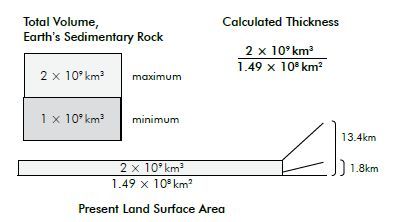
There are a variety of estimates of the total volume of sedimentary rocks, most ranging between one and two billion cubic km.22 Holt falls on the low end of that estimate when he includes Precambrian metasedimentary rocks and continental margin and seafloor sediments.23 Assuming a flat surface, Earth’s total surface area is 510,072,000 km2. Of that, 148,940,000 km2 is present-day land.24 On the continents, the total average thickness is about 1.8 km. The worst case possible for the Flood’s depositional power would be to take the high end of 2 billion cubic km deposited on the present-day land surfaces. If that total volume of sediment was deposited on that small land surface during the 371 days of the Flood (figure 3), then the total average thickness of sedimentary rock would be 13.43 km (44,062 ft), a thickness found today only in deep sedimentary basins. Since geologists have calculated the actual average thickness of sedimentary rocks on the continents as only 1,800 m (5,906 ft),25 it is clear that the worst possible approach is wildly conservative. Even so, it requires the Flood to have deposited an average daily rate of 36 m (118 ft) per day on the present continents. Contrary to secular geology, that is not farfetched. We only need examine rates of modern day, high-energy processes. If we used the actual continental estimate of 1,800 m average thickness, the daily Flood average would only be a mere 4.85 m (16 ft) per day.
Some might argue that although an average thickness might be achieved, the tens of thousands of feet in deep sedimentary basins, clearly deposited in only part of the Flood, would be impossible to achieve. In those cases, it is incumbent on the critics to demonstrate that impossibility, given sufficient sediment source and the hydraulic magnitude of the floodwater. Currents hundreds of feet deep and hundreds of miles wide flowing at elevated velocities would have a correspondingly high carrying capacity. As has been argued for many decades, time is only one factor; geologic activity rises with energy.
With regard to the average daily depositional rates, modern local catastrophic events meet or exceed these rates. Thus, geologists who accept the principle of actualism have little room to complain about the capacity of the Flood to deposit thick sequences of sediment, especially since they—as neocatastrophists—accept rapid, catastrophic deposition. For example, a levee breach in New Orleans during Hurricane Katrina deposited approximately a metre of sediment in the Lower Ninth Ward neighbourhood in just 46 minutes.26 At the 1980 eruption of Mt Saint Helens, approximately 183 m (600 ft) of landslide material accumulated following the collapse of the north side of the mountain. Given these modern examples, it is clearly the skeptics who have erred in claiming that great thicknesses of sedimentary rock could not be deposited. Even the overly high estimate of 36 m per day is not unreasonable—indeed, it is only slightly higher than the actual rate of deposition from the Katrina levee break.
There were obviously locales where the rate was much higher, just as there were locales where the rate was much lower. But the original argument that the Flood could not have deposited the volume of sedimentary rock is proven incorrect.
Supposed slow processes deduced from the strata
The early geologists rejected the historicity of Noah’s Flood because of: (1) the volume of strata, and (2) seeming evidence in the rocks of slow processes. Their first argument is invalid; had the 18th-and 19th-century scientists actually calculated the sedimentation rates at particular locations and compared them to the hydraulic potential of the Flood, they would have seen that the derived rates for the Flood are not unrealistic. That this exercise was apparently not attempted suggests a powerful bias against the Flood, creating errors in their argument. Similar defects in their other arguments for slow deposition should then be expected. We will focus on present-day, rather than outmoded, arguments since they represent a greater empirical knowledge of the rock record.
Bedding and lamination (including varves)
For many decades, geologists believed that bedding, especially fine lamination, required long periods of time for tranquil processes to create the individual layers. This assumption was applied to everything from sandstone beds to evaporite laminae to varves. However, recent research and field examples have begun to show otherwise. In the late 20th century, geologists tried to match modern depositional environments to the rock record via facies modelling. However, a more rigorously scientific approach has been found in the growing work of quantitative sedimentologists, using both lab and field data to integrate sedimentation and fluid dynamics. For example, Berthault has shown that with particles of different sizes, masses, and densities, fine and medium-sized layers form quite rapidly in water and in air, especially with a moving current.27 Others have applied those methods to the rock record28 and to modern sedimentation examples,26 showing that sedimentary bedding—and even fine laminations—can form in a matter of minutes.

A classic ‘slow deposition’ argument is that of varves.29 Thin rhythmites are seen throughout the rock record (figure 4) and these are often claimed to be varves, ‘proving’ slow sedimentation over thousands, or even millions, of years. But thin alternating laminae can form quickly.30 The fact that millimetre-thick laminae can be traced over 114 km (71 miles) in the Castile Formation of west Texas negates modern environment analogs.30 The Castile Formation is composed of halite and anhydrite, and has tens of thousands of thin laminae. Since there is no observed example of this type of sedimentation, the actualistic method fails. Such large-scale layers of such unusual composition suggest large-scale unusual processes. Secular explanations of the Castile Formation strain credulity.
Shales and mudstones
Shales and mudstones make up about 80% of the sedimentary record.31 These rocks are composed of very fine particles, less than 1/256 mm, which were once believed to have been deposited very slowly as clay particles settled through a stationary water column. But these clay-sized particles can be deposited rapidly by several processes. For example, these particles flocculate, forming larger clumps of particles that sink faster. Furthermore, mud can be deposited rapidly in currents once thought too fast for mud deposition.32
Reefs and paleosols
Carbonate features interpreted as ancient reefs are found in the rock record. Much research remains to be done, but many of the ‘ancient reefs’ appear to be quite different from modern reefs. For example, the organisms in many ancient ‘reefs’ do not form framework reefs, and even the organisms that make up the ‘reefs’ are different from those found today.33 Many of the ancient ‘reefs’ could easily be allochthonous piles of carbonate debris (i.e. washed into place).
Secular geologists also think that paleosols are natural chronometers. These so-called ancient soils are found in many places and many horizons. However, ‘paleosols’ do not exhibit features of modern soil horizons, especially the organic layer. It is claimed that these layers were apparently eroded or altered, but this is an argument from silence. When compared to modern soils, paleosols exhibit other inconsistencies.34 Distinct layers of clay, carbonate, or other materials, often interpreted as soil horizons, are more likely the result of diagenetic processes by hydrothermal fluids, groundwater, or migrating pore fluids. Numerous research opportunities exist for those willing to examine the data from a different perspective.
Cementation and fossilization
Cementation and fossilization are processes claimed to require long periods of time, much more than the Flood year. But the physico-chemical environment is a much greater factor than time. Cementation and fossilization can both occur rapidly under the right conditions, e.g. the fossilization of a miner’s felt hat within a few tens of years.35 We see rapid cementation every time concrete is poured.
|
|
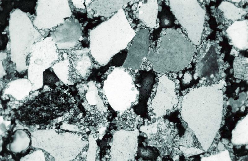
Figure 5. (A) Silica in pore fluids formed overgrowths on corroded quartz grains and chert cement (upper middle). Scale on bottom. (B) Dolomite rhombs are beginning to coat grains and infill pore spaces as cementation progresses. |
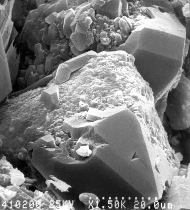
Numerous minerals act as cements in the rock record; carbonate and silica are common. During cementation, ions enter the pore spaces of sedimentary rocks via pore fluids. The chemistry of these fluids can vary significantly, as can the temperature, pressure, pH, and Eh. When the chemical environment meets specific parameters, carbonate, silica, or other cements bind to the edges of grains, often with bonds stronger than the grains themselves (figure 5). Cement can make up a significant percentage of a rock body.
Although geologists claim that cementation is a problem for diluvialists,36 it is just as bad for secular geologists, especially when trying to explain the unusual chemical conditions required for cementation. For example, there must be a large volume of silica in pore fluids to cement sandstone. Geologists can measure silica concentrations in modern groundwater, but silica is often undersaturated in groundwater, making the uniformitarian or actualistic explanation difficult.37 Pettijohn38 noted: “A cemented sandstone stratum 100 m thick, for example, contains within it enough cementing material to form a layer 25 to 30 m thick if these materials were segregated.” Where did the cement come from and how was it distributed through the rock?
Fossilization is also a problem for old-earth geologists.39 The primary requirement for fossilization is rapid burial. The size of the organism defines the necessary rate. A thin trace can be covered by a thin layer of mud, but a tree trunk can require tens of feet of sedimentation in a short time. In some cases, an organism’s original substance is replaced by mineralization, as exemplified by petrified wood. But this must happen before the original material decays. In many sedimentary environments, organisms decay quickly, even after burial. Most geologists admit that fossilization is rare today, yet there are vast numbers of fossils in the rocks. Not only must their rapid formation at regional scales be explained, but once again the actualistic principle fails to explain field observations.
The Genesis Flood would have been a near-perfect environment for fossilization. Organisms and sediments were buried rapidly and deeply. The elevated fluid content of these sediments would have migrated rapidly in response to compaction and overpressure. Igneous, metamorphic, and tectonic processes would have altered the temperature and chemistry of pore fluids, causing rapid diagenesis and cementation. High pressure gradients would have caused the fluids to move rapidly through the sediments, preventing equilibrium conditions from being established. Features such as chert layers, quartz dikes, and nodules indicate conditions favouring silica precipitation, something rarely seen today.
Tracks, burrows, and nests
Many argue that fossil animal tracks, burrows, and nests indicate long periods of time of sedimentation. However, these and other ephemeral features can be explained as products of the early phases of the Flood.40 These features could have formed in areas where sedimentation was rapid and heavy, and where abrupt changes in base level (whether from eustatic change or tectonism) would have exposed an extensive flat bedding surface. For example, dinosaur tracks, nests, and eggs are often seen as arguments that surrounding rocks were not produced during the Flood. But if sedimentation was ongoing, newly deposited sediments could have served as substrate for animal tracks. With more sedimentation, multiple layers of track-bearing rocks would have quickly accumulated. These briefly exposed diluvial sediments would be ideal environments to preserve ephemeral traces like tracks, as well as nests, eggs, and scavenged carcasses. At the same time burrowing organisms would have been active, introducing more conventional trace fossils. Other exotic features, such as mudcracks and raindrop imprints, could have been preserved in the same way.
Indicators of rapid deposition
Although much remains to be learned, it is clear from a few decades of work by a few Flood geologists that many so-called uniformitarian challenges to the Flood can be met. But what about diluvial challenges to secular natural history? There are a number of features of the rock record that suggest rapid, catastrophic deposition. If diluvialists are required to explain problems with their model, then why are not secular geologists held to the same standard? We will summarize four of these challenges.
1. Large horizontal extent of many layers
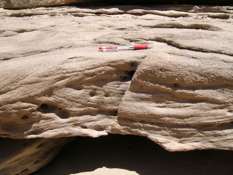
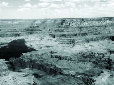
Many sedimentary layers can be traced over long distances, contrary to currently observed processes. For instance, the Tapeats Sandstone at the bottom of the Grand Canyon, lying on top of the basement granites and metamorphic rocks, is a coarse sandstone about 60 m thick containing abundant quartz pebbles (figure 6). Resting on top of the Tapeats is the green Bright Angel Shale, which contains features that appear to be worm burrows. The sequence is capped by the Muav limestone.41
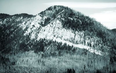
This same sequence of sandstone–shale–limestone overlying igneous basement rocks can be traced northward into Wyoming and Montana, although the formations are called different names. For example, the sandstone further north is called the Flathead Sandstone, but it is similar to the Tapeats, overlying the basement granites (figure 7). On top of the Flathead Sandstone is a green shale with abundant ‘worm burrows’ (figure 8), which in turn is overlain by carbonate strata. Reed noted a sequence of sand and conglomerate grading into a thick carbonate sequence in Oklahoma.42 In fact, Snelling claims that the Tapeats Sandstone and its equivalents can be traced mostly on top of basement rocks over much of North America.43 This is continental-scale sedimentation. Many other formations are of regional scale.

|

|
Deposition by observed modern processes does not generate regional-scale beds of sediment. Different environments of deposition create different stratal geometries, but they are restricted in areal extent. However, the Flood would be expected to generate geographically extensive deposits due to its scale and intensity.
2. The lack of erosion within and between layers
Secular geologists since the 18th century have thought sedimentary strata required much time to form. But if so, then these strata should show evidence of erosion within the formations and at their boundaries, as seen in modern landscapes where streams and rivers dissect the landscape and do significant erosion in decades or centuries. Shorelines changing due to minor fluctuations in relative sea level should also generate erosion. But thick deposits, such as those seen at Grand Canyon (figure 9), show little, if any, erosion within layers or at contacts. Secular geologists claim that the thick horizontal sequence at Grand Canyon represents over 300 Ma of low-energy sedimentation, with seas migrating back and forth across the area. If so, there should be significant erosional features seen in the layers forming the canyon walls. Erosion presents another problem for long-age geologists. At the current rate of erosion, all of North America would be reduced to sea level in as little as 10 Ma44 or, at most, 33 Ma.45 Given that, the sedimentary sequence at Grand Canyon should show evidence of massive erosion. This evidence does not exist.
The same is true of sedimentary rocks worldwide—there is often little or no erosion between the layers; deformation often occurs after deposition by faulting, folding, and tectonism. For example, strata found on the south side of the Teton Mountains of northwest Wyoming (figure 10) were deposited before being uplifted and eroded, leaving a 2,000-foot sequence very close to that of the lower Grand Canyon. So, little (if any) erosion can be seen between the layers of this sequence, and some geologists think the layers look like they were deposited in one single uninterrupted sequence: “The regularity and parallelism of the layers in well-exposed sections suggest that all these rocks were deposited in a single uninterrupted sequence.”46
Despite the physical evidence, secular geologists still think the beds were deposited over 200 Ma, based on the fossil dating scheme developed in the 1800s. Other examples could be cited. The lack of erosion between and within these layers is powerful evidence for rapid deposition consistent with the Genesis Flood and is another example of the failure of actualism.
3. Closed-shelled mollusks
Not only do the sedimentary rocks point to the Genesis Flood, but their fossils do too. Bivalve mollusks are commonly found as fossils.47 It is observed today that when these types of organisms die the muscle attachments weaken and the shells opens up within hours. However, fossil bivalves are often found with their shells closed, meaning they were killed and buried within hours. Thick, widespread beds containing these types of fossils must have been deposited very rapidly.
4. Polystrate fossils
Secular geologists emphasize modern processes, especially those that support their time scale. They estimate that the average rate of sedimentation is around 1 cm/1000 years. That low rate is one reason they claim that most strata represent millions of years. But that conflicts with indicators of rapid sedimentation, such as closed-shelled fossils. Another indicator of rapid sedimentation is a feature called polystrate fossils.
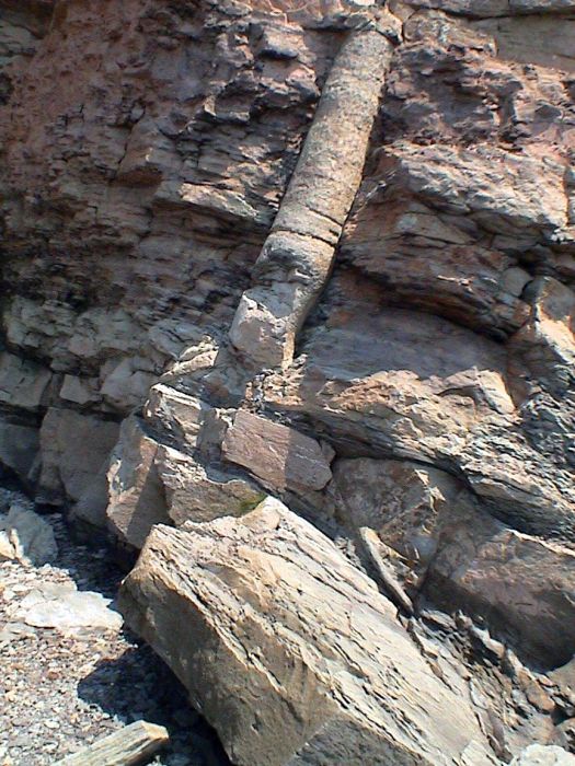
Polystrate fossils are fossils that penetrate more than one sedimentary layer. Such fossils are relatively common and are most often represented by trees (figure 11). Polystrate trees are equally preserved along their entire length, indicating that the tree was rapidly covered, since decomposition would have occurred within weeks to months. Polystrate fossils contradict the predicted average rate of sedimentation.
Actualistic geologists attempt to explain this field evidence by claiming that deposition was rapid only in one location and only for a short period of time. While it is true that modern examples of local, rapid sedimentation are observed, polystrate fossils often cross bedding planes and strata representing millions of years as defined by other dating methods, such as biostratigraphy or radiometric dating. In these cases, there is a clear conflict that cannot easily be explained. For example, some polystrate trees penetrate multiple coal seams,48 even though coal is assumed to have formed very slowly in a peat swamp environment. The presence of both polystrate fossils and coal seams requires that either the environmental explanation is wrong or that there is an unknown mechanism for preserving trees for thousands of years in such an environment.
Polystrate fossils are no problem for diluvialists. In addition to conditions of rapid and violent sedimentation and fossilization, a specific mechanism for Flood polystrate fossils was seen in the development of log mats at Spirit Lake after the 1980 Mount St Helens eruption. These trees later sank, often in a vertical position. In a Flood setting, the combination of vegetation mats and rapid sedimentation can easily explain polystrate trees.49,50
Conclusion
Since the 1700s, geognosts have used the volume and thickness of sedimentary formations as an argument against the Flood. With the development of geology in the 19th and 20th centuries, these arguments increased in sophistication, moving from total volume to small-scale sedimentary features. The original argument from sedimentary volume does not hold up against the expected hydraulic conditions of the Flood. Even isolated modern examples exceed or meet the rates needed to deposit all of the sedimentary rocks.
More recent arguments from particular sedimentary features, including: laminations, varves, paleosols, preserved nests, burrows, and tracks of various creatures do not stand up to strict scrutiny. Furthermore, there are a number of sedimentary indicators that suggest large-scale rapid deposition and these features are difficult for secular geologists to explain.
This means that all three of the original arguments for deep time, valley erosion, volcanic terranes, and the geognostic pile, are invalid. It seems clear that the early geologists did not understand the rock record or the nature of their discipline as well as they thought they did. Valley erosion is a function of process, not time. Rates of volcanic accumulation are determined by the energy of the eruption, not time. The sedimentary record can be explained in terms of the Flood, both in gross volume and fine features. Factors other than field evidence seemed to have driven geological interpretation from the earliest days of the discipline. Subjective rejection of biblical history combined with a commitment to gradualism to drive the secular view of earth history decades before Lyell. Even the interpretations of the geognosts illustrated the role of assumptions in interpreting the past:
“Füchsel’s published block diagram of the Secondary formations of Thuringia and Lehmann’s earlier section through the same region, had a similar effect. Lehmann had still attributed all his formations to a gigantic Deluge, but a generation later most savants who had seen such evidence with their own eyes in the field, or who had at least been turned into virtual witnesses by the persuasive accounts of others, concluded that the Secondary formations must have needed humanly inconceivable spans of time for their deposition.”51
Since the original arguments for deep time are all invalid, there should be a record of geologists objectively evaluating Earth’s age once evidence of the failure of these arguments became known. This did not happen. Instead, secular geologists used deep time as a starting point, and interpretations that reached the conclusion of vast ages naturally followed. This continued fallacy of assuming the conclusion strongly suggests that belief in deep time is a subjective commitment of secular earth scientists, not the objective conclusion of valid field evidence.
References
- Please note that arguments about the quantity of time are irrelevant to the basic concept that there was a lengthy prehuman prehistory. Return to text.
- Reed, J.K., Three early arguments for deep time, part I: time needed to erode valleys, J. Creation 25(2):83–91, 2011. Return to text.
- Reed, J.K., Three early arguments for deep time, part II: volcanism, J. Creation 26(1):61–70, 2012. Return to text.
- This term was used by Rudwick (see refs. 5 and 12) to emphasize the importance of geognosy as the precursor to what we know today as stratigraphy. Return to text.
- Rudwick, M.J.S., Bursting the Limits of Time: The Reconstruction of Geohistory During the Age of Revolution, University of Chicago Press, Chicago, IL, p. 84, 2005. Return to text.
- Laudan, R., From Mineralogy to Geology, University of Chicago Press, Chicago, IL, 1987. Return to text.
- Rudwick, ref. 5, pp. 89, 97. Return to text.
- Rudwick, ref. 5, pp. 96–97. Return to text.
- Rudwick, ref. 5, pp. 90–91, brackets his. Return to text.
- Rudwick, ref. 5, p. 94. Return to text.
- E.g., Reed, J.K., St. Hutton’s hagiography, J. Creation 22(2):121–127, 2008. Return to text.
- Rudwick, M.J.S. Worlds Before Adam: The Reconstruction of Geohistory in the Age of Reform, University of Chicago Press, Chicago, IL, p. 37, 2008. Return to text.
- Rudwick, ref. 12, p. 37, n4. Return to text.
- Rudwick, ref. 5, p. 173. Return to text.
- Reed, J.K., Toppling the timescale, Part II: unearthing the cornerstone, Creation Research Society Quarterly 44(4):256–263, 2008. Return to text.
- Rudwick, ref. 5, p. 123. Return to text.
- Rudwick, ref. 5, p. 175. Return to text.
- Rudwick, ref. 5, p. 125. Return to text.
- Rudwick, ref. 5, p. 124. Return to text.
- E.g. the recolonization model; the Creation, Curse, Catastrophe model; the Collapse Tectonics model. Return to text.
- Young, D.A. and Stearley, R.F., The Bible, Rocks and Time: Geological Evidence for the Age of the Earth, IVP Academic, Downers Grove, IL, p. 378, 2008. Return to text.
- Some estimate sedimentary rocks comprise 5% of the volume of the crust en.wikipedia.org/wiki/Sedimentary_rock and sourcerocks.blogspot.com/2010/04/sedimentary-rocks.html (April, 2011). For a better estimate, see Holt, R., Evidence for a late Cainozoic Flood/post-Flood boundary, J. Creation (formerly Creation ex Nihilo Technical J.) 10(1):128–167, 1996. For more information, see Holt’s references of Ronov and Hay, Pettijohn, and Blatt. Return to text.
- Holt, ref. 22. Return to text.
- en.wikipedia.org/wiki/Earth, May 2011. Return to text.
- Nelson, S.A., Occurrence, mineralogy, textures, and structures of sedimentary rocks, www.tulane.edu/~sanelson/geol212/sedrxintro.htm, accessed May 2011. Return to text.
- Barnhart, W.R., Hurricane Katrina splay deposits: hydrodynamic constraints on hyperconcentrated sedimentation and implications for the rock record, CRSQ 48(2):123–146, 2011. Return to text.
- Berthault, G., Experiments on stratification; in: Walsh, R.E. (Ed.), Proceedings of the Third International conference on Creationism, technical symposium sessions, Creation Science Fellowship, Pittsburgh, PA, pp. 103–110, 1994. Return to text.
- Lalamov, A. and Tugarova, M.A., Reconstruction of paleohydraulic conditions of deposition of Permian strata of Kama Region studied by Golovkinsky, REPORT for 2008 joint research of Geological Laboratory ARCTUR (Moscow) and Lithological department of Geological Faculty of St.-Petersburg State University, 2011. Lalamov, A. Paleochannels of Ural folded belt and piedmont area: reconstruction of paleohydraulic conditions, Final Report for 2006–2007 joint research of Geological Laboratory ARCTUR (Moscow) in co-operation with Institute of Geology of Ore Deposits Russian Academy of Science (IGEM RAS) and Research–Exploration Centre “Monitoring” (Khanty–Mansiisk, West Siberia), 2008. Return to text.
- Antevs, E., The recession of the last ice sheet in New England, American Geographical Society Research Series No. 11, New York, 1922. Anderson, R.Y. and Dean, W.E., Lacustrine varve formation through time, Palaeogeography, Palaeoclimatology, Palaeoecology 62:215–235, 1988. Kirkland, D.W., An explanation for the varves of the Castile evaporites (Upper Permian), Texas and New Mexico, USA, Sedimentology 50:899–920, 2003. Return to text.
- Oard, M.J., Do varves contradict biblical history? in: Oard, M.J. and Reed, J.K. (Eds.), Rock Solid Answers, pp. 125–148, Master Books, Green Forest, AR, 2009. Return to text.
- Pettijohn, F.J., Sedimentary Rocks, 3rd edition, Harper and Row, New York, 1975. Return to text.
- Walker, T., Mud experiments overturn long-held geological beliefs, J. Creation 22(2):14–15, 2008; Schieber, J., Southard, J. and Thaisen, K., Accretion of mudstone beds from migrating floccule ripples, Science 318:1760–1763, 2007; Macquaker, J.H.S. and Bohacs, K.M., On the accumulation of mud, Science 318:1734–1735, 2007. Return to text.
- Whitmore, J.H., Modern and ancient reefs; in: Oard, M.J. and Reed J.K. (Eds.), Rock Solid Answers, Master Books, Green Forest, AR, pp. 149–166, 2009. Return to text.
- Klevberg, P., Bandy, R., and Oard, M.J., Do paleosols indicate long ages? in: Oard, M.J. and Reed J.K. (Eds.), Rock Solid Answers, Master Books, Green Forest, AR, pp. 93–110, 2009. Froede Jr, C.R. Flood by Design, Master Books, Green Forest, AR, 2007. Return to text.
- creation.com/fossil-hat, May 2011. Return to text.
- Young, D.A. and R.F. Stearley, The Bible, Rocks and Time: Geological Evidence for the Age of the Earth, IVP Academic, Downers Grove, IL, p. 378, 2008. Return to text.
- Molenaar, N., Cyziene, J. and Sliaupa, S., Quartz cementation mechanisms and porosity variations in Baltic Cambrian sandstones, Sedimentary Geology 195:135–159, 2007. Return to text.
- Pettijohn, ref. 31, p. 239. Return to text.
- Whitmore, J.H., Fossil preservation; in: Oard, M.J. and Reed, J.K. (Eds.), Rock Solid Answers, pp. 231–244, Master Books, Green Forest, AR, 2009. Return to text.
- Oard, M.J., Dinosaur Challenges and Mysteries: How the Genesis Flood Makes Sense of Dinosaur Evidence—Including Tracks, Nests, Eggs and Scavenged Bones, Creation Book Publishers, Powder Springs, GA (in press). Return to text.
- Austin., S.A., Grand Canyon: Monument to Catastrophe, Institute for Creation Research, El Cajon, CA, 1994. Berthault, G. Sedimentological Interpretation of the Tonto Group Stratigraphy (Grand Canyon Colorado River), Lithology and Mineral Resources 39:480–484, 2004. Return to text.
- Reed, J.K., Geology of the Timbered Hills Group in Oklahoma, CRSQ 42(1):39–66, 2005. Return to text.
- Snelling, A.A., Transcontinental rock layers, Answers 3(3):80–83, 2008. Return to text.
- Roth, A.A., Origins: Linking Science and Scripture, Review and Herald Publishing Association, Hagerstown, MD, pp. 263–266, 1998. Return to text.
- Schumm, S., Disparity between present rates of denudation and orogeny, USGS Professional Paper 454, Washington, DC, 1963. Return to text.
- Love, J.D., Reed Jr, J.C. and Pierce, K.L., A Geological Chronicle of Jackson Hole & the Teton Range, Grand Teton Association, Moose, WY, p. 42, 2007. Return to text.
- Morris. J.D. and Sherwin, F.J., The Fossil Record: Unearthing Nature’s History of Life, Institute for Creation Research, Dallas, TX, p. 41, 2010. Return to text.
- Rupke, N.A., Prolegomena to a study of cataclysmal sedimentation; in: Lammerts W.E. (Ed.). Why not creation? Baker Book House, Grand Rapids, MI, pp. 141–179, 1970. Return to text.
- Oard, M.J., Polystrate fossils require rapid deposition, CRSQ 43(4):232–240, 2007. Return to text.
- Coffin, H.G., The Yellowstone petrified ‘forests’, Origins 24(1):5–44, 1997. Return to text.
- Rudwick, ref. 12, p. 124. Return to text.


Readers’ comments
Comments are automatically closed 14 days after publication.