

How did the waters of Noah’s Flood drain off the continents?

Many ask: “If Noah’s Flood really covered the whole earth, then where did the water go?”
This question has a simple answer, and once we understand what happened and how, we can see the reality of the biblical Flood all around the world.
The floodwater is in the oceans
Actually, the Bible tells us where the water went. By Day 150 of the Flood catastrophe the floodwaters had risen until they covered “all the high mountains under the whole heaven” (Genesis 7:19). After that “the waters receded from the earth continually” (Genesis 8:3), a process that took about seven months.
As the water receded from the continents it must have flowed into the oceans. It only takes a quick look at a globe of the earth to appreciate that the water indeed sits in the oceans. The Pacific Ocean alone takes up almost half the earth’s surface (Figure 1).
The crust goes up and down

Logically, the only way for the water to drain from the continents into the oceans is for the continents to rise and the ocean floors to sink. As our knowledge of the structure of the earth has grown we can appreciate how that could have happened.
The top part of the earth, called the crust, sits on top of the mantle (about 3,000 km (1,900 miles) thick), which in turn sits on the earth’s iron core. The continental crust is about 40 km (25 miles) thick, while the thickness of the oceanic crust is only around 7 km (5 miles). Up-and-down movement of the crust during Noah’s Flood, called differential vertical tectonics, explains how the waters drained from the continents. On a smaller scale, mountain ranges would have risen and valleys sunk.
As the continental crust rose and the ocean floors sank, the floodwater covering the globe drained off, causing massive erosion of the continents.1 By the time the floodwaters had fully receded, the surface had been transformed into its present shape. After that, Noah and all those with him left the Ark, 371 days2 after the Flood had begun (Genesis 8:18–19).
As the ocean basins began to sink, the water flowed across the continents in wide sheets, shaving the surface flat. Geologists call such features ‘planation surfaces’.3 The runoff eroded the uplifting mountains, transporting the rock debris across the continent, and rounding any hard, resistant rocks into boulders and gravel. Large deposits of well-rounded quartzite rocks are found at numerous places in the northwest United States and adjacent Canada.4


Toward the end of the Flood, mountain ranges began to emerge above the water and the runoff became more channelized. These flowed across mountain ranges, ridges, and plateaus, eroding gorges from one side of the barrier to the other, a feature called a water gap, through which a river or stream now passes.5
Is there evidence for up-and-down movements?
Indeed, there is abundant evidence for differential vertical tectonics of mountains and valleys, and continents and oceans. This is revealed through the study of geomorphology, i.e. the shape of the earth’s surface.6 Mountains show evidence of upward movement along faults, while the adjacent valleys show evidence they have sunk down, and then collected sediments. The sediments prove that the movement started while the land was still under the floodwater.
As the ocean basins sank, thousands of metres of sediment washed off the continents, forming the continental margin. These margins are evidence the ocean basins near continents sank. Further evidence of ocean basins sinking are flat-topped undersea volcanoes called guyots (Figure 2), found far from land. Water currents shaved these smooth, and they now sit at an average of about 1,500 metres (5,000 ft) below sea level. Secular geomorphologist and world traveller, Lester King, exclaimed:
“Marine volcanic islands which have been truncated by the waves and since subsided below sea level are called guyots. Most of them seem to have sunk by 600 to 2,000 m [2,000 to 6,500 ft] and it is evident that they afford a measure of the amount by which the ocean floor has sunk in late geologic time. … All the ocean basins afford evidence of subsidence (amounting to hundreds and even thousands of metres) in areas far from land [emphasis mine, parentheses his].”7
Even the fine details of the ocean bottom, deep beneath the surface, show signs of differential vertical tectonics in the crust—that areas rose and sank. Abyssal hills are found over most of the deep ocean crust, although they are mostly covered by sediments. They are narrow ridges typically 10 to 20 km (6 to 12 miles) long, 2 to 5 km (1.2 to 3 miles) wide, and 50 to 300 metres (160 to 1,000 ft) or more high (Figure 3).8
A worldwide phenomenon
Consistent with the Genesis Flood, the upward and downward movement in the earth’s crust is a worldwide phenomenon. Lester King summarizes:
“So the fundamental tectonic mechanisms of global geology are vertical, up or down: and the normal and most general tectonic structures in the crust are also vertically disposed … But one must bear in mind that every part of the globe—on the continents or in the ocean basins—provides direct geological evidence that formerly it stood at different levels, up or down… [emphasis mine]”9
Indeed, there is abundant evidence of differential vertical tectonics during Flood runoff.
The covering of Mount Everest ‘challenge’—answered

Many consider the height of Mount Everest at 8,848 metres (29,029 ft—Figure 4) a fatal flaw for the Genesis Flood. How could the floodwater have topped the mountains, they ask? Even if the ocean floor was raised to sea level, the present water on the earth would be only 2,700 metres (8,800 ft) deep, one-third the depth needed to cover Mount Everest. Differential vertical tectonics as the floodwater was draining provides the answer,10 because the mountains were pushed up as a result of the Flood, by way of upward vertical tectonics.
It is clear that the mountains were once under the ocean because the sedimentary rocks that form the tops of most mountains contain marine fossils. For example, Mount Everest is topped with marine crinoid (sea lily) fossils embedded in limestone.11
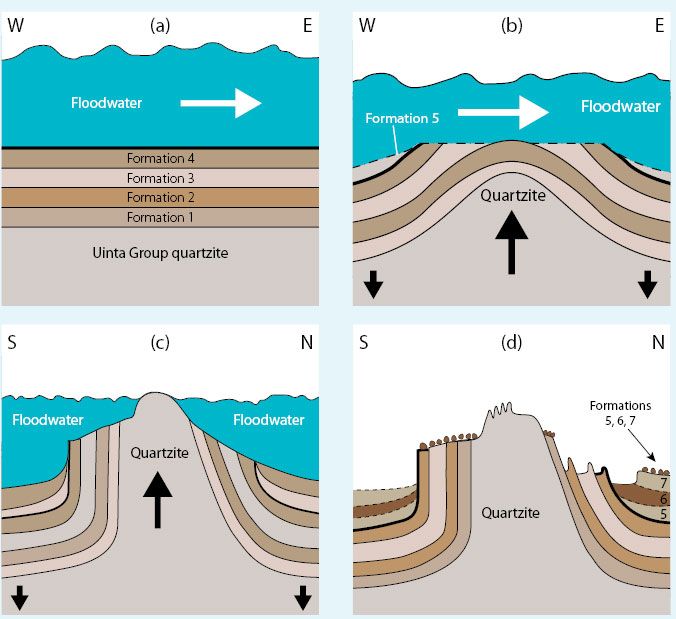
This means that Mount Everest and the other high mountains in our present world, with their sedimentary rocks and fossils, rose up out of the floodwater during the later stages of the Flood. Figure 5 illustrates how, as the floodwater drained, the Uinta Mountains of the western United States rose about 12,000 metres (40,000 ft) compared with the same type of rock in the basins to the north and south, which sank with other sedimentary rocks filling the basins (formations 5–7, Figure (5d)).
Conclusion
So, it was mountains rising and valleys sinking that caused the floodwater to drain at the end of Noah’s Flood. The water moved toward the low spots on the planet and the rising land was exposed.12 As a result of vertical movements in the earth’s crust, the continents and mountains rose at the same time as the valleys and ocean floors sank. The mountains were first to rise above the water, which explains why the Ark grounded on the “mountains of Ararat” (Genesis 8:4). If the Genesis Flood was a local event, the Ark would have been carried downstream. Assuming it didn’t sink, it would have landed on a flood plain or been washed into the ocean. Scripture is strikingly consistent in declaring the Genesis Flood as a global event, and the features on the surface of the earth are in full agreement.
References and notes
- Oard, M.J., Massive erosion of continents demonstrates Flood runoff, Creation 35(3):44–47, 2013; creation.com/continental-erosion. Return to text
- Whitcomb, J.C., and Morris, H.M., The Genesis Flood, The Presbyterian and Reformed Publishing Company, pp. 2–3, 1961. Return to text
- Oard, M.J., It’s plain to see: flat land surfaces are strong evidence for the Genesis Flood, Creation 28(2):34–37, 2006; creation.com/its-plain-to-see. Return to text
- Hergenrather, J., Noah’s long-distance travellers: Quartzite boulders speak powerfully of the global Flood, Creation 28(3):30–32, 2006; creation.com/noahs-long-distance-travelers. Return to text
- Oard, M.J., Do rivers erode through mountains? Water gaps are strong evidence for the Genesis Flood, Creation 29(3):18–23, 2007; creation.com/do-rivers-erode-through-mountains. Return to text
- Oard, M.J., Earth’s Surface Shaped by Genesis Flood Runoff, michael.oards.net/GenesisFloodRunoff.htm, 2013; Oard, M.J., Flood by Design: Receding Water Shapes the Earth’s Surface, Master Books, Green Forest, AR, 2008; Oard, M.J., How the Earth Was Shaped, Creation Ministries International DVD, 2013. Return to text
- King, L.C., Wandering Continents and Spreading Sea Floors on an Expanding Earth, John Wiley and Sons, New York, NY, pp. 168, 71, 1983. Return to text
- Macdonald, K.C., Fox, P.J., Alexander, R.T., Pockalny, R., and Gente, P., Volcanic growth faults and the origin of Pacific abyssal hills. Nature 380:125–129, 1996. Return to text
- King, Ref. 7, pp. 16, 71. Return to text
- Oard, M.J., Mt Everest and the Flood. In, Oard, M.J., and Reed, J.K. (editors), Rock Solid Answers: The Biblical Truth Behind 14 Geological Questions, Master Books and Creation Research Society Books, Green Forest, AR and Chino Valley, AZ, pp. 19–27, 2009. Return to text
- Gansser, A., Geology of the Himalayas, Interscience Publishers, New York, NY, p. 164, 1964. Return to text
- The phrase “The mountains rose; the valleys sank down” comes from Psalm 104:8. It is possible that Psalm 104:6–9 refers to the drainage of the waters of Noah’s Flood. See Taylor, C., Did mountains really rise according to Psalm 104:8? J. Creation 12(3):312–313, 1998 and Taylor, C., More on mountains—Charles Taylor replies. J. Creation 13(1):70–71, 1999. Return to text


Readers’ comments
Comments are automatically closed 14 days after publication.