

Learning the lessons of Mount St Helens
How its eruption backs biblical history
It was not until I visited Mount St Helens volcano in Washington State, USA, that I fully appreciated the immensity of its 1980 explosion. Over many years, I had learned a lot about the eruption, watching videos, listening to lectures, and reading reports. When the mountain blew up physically, it also blew away many false ideas about geology, ideas that were wrong, but had been believed for more than a century.

After decades of inactivity, Mount St Helens coughed to life in March 1980, some two months before its explosive eruption. Its smoke and rumbling were warning that something big was building up. Officials set up an exclusion zone around the volcano based on scientists’ ideas about how an eruption would occur. However, the blast was larger than expected, plus it first erupted sideways to the north instead of vertically. Of the 57 people that died, all but three were outside the exclusion zone. Wrong geological ideas can be deadly.
Wrong geological ideas have also led people to wrong ideas about the Bible—that the events it describes were mythological and did not actually happen. Mount St Helens changed that, which is why I have been so interested in what happened. The eruption demonstrated that geologic catastrophe can produce in hours and days geologic features previously believed to have taken millions of years. When we see what the volcano did in such a short time, we can better appreciate how the catastrophe of Noah’s Flood formed the much larger geological features on planet Earth.
For many years, geologist Dr Steven Austin researched the geological effects of the Mount St Helens eruption and its aftermath. He published extensively on how that catastrophe sheds light on the global catastrophe of Noah’s Flood, which is a key to confirming the Bible’s truth.1
 |
 |
Geological layers form in hours
One of the many surprising results was an 8 m (25 ft) thick sedimentary deposit exposed in a cliff alongside the North Fork Toutle River (figure 4). It is composed of finely-layered sediment (figure 5). From eyewitness reports, photographs, and monitoring equipment, it is known that this whole deposit formed in just three hours, from 9 pm to midnight on 12 June 1980.1 It was deposited from black clouds of fine, hot ash mixed with gas, blasting at high speed from the volcano—a pyroclastic flow. Ash-laden and heavier than air, the flow surged down the side of the volcano and along the river valley at more than 160 km/hr (100 mph), hugging the ground and depositing ash.
The big surprise was that the sediment deposited in fine layers called laminae. You would expect a catastrophic, high speed ash flow to churn the fine particles and form a uniform, well-mixed deposit. Thus, it had been conventionally thought that fine layers had to accumulate very slowly one upon the other over hundreds of years. But Mount St Helens showed that the coarse and fine material automatically separated into thin, distinct bands, demonstrating that such deposits can form very quickly from fast flowing fluids (liquids and gases). Since then, laboratory experiments have shown that fine laminae also form quickly from flowing water.2 This shows how finely-layered sandstone deposits in other situations, such as some of the lower layers in the Grand Canyon,1 likely formed rapidly, which could have happened within the time-scale of Noah’s Flood.
 |
 |
Canyons carved quickly
The Mount St Helens eruption also demonstrated how canyons can be formed much faster and in a different manner than conventionally thought. Ongoing eruptions eroded the thick sediment dumped at the base of the volcano, producing multiple channels and canyons. One such channel was dubbed ‘Little Grand Canyon’ (figure 6), being about 1/40th the size of Grand Canyon.1 Its side walls were up to 40 m (140 ft) high, its width up to 45 m (150 ft), and a small stream of water ran through it. Someone coming across that canyon could easily conclude that it was eroded slowly and gradually by the small creek now running through it, over many hundreds or thousands of years.
However, the formation of this canyon was documented. It was carved by a mudflow caused after a small eruption of Mount St Helens melted snow within the crater on 19 March 1982. The mud built up behind debris, burst through it, and cut the canyon in a single day. So, the creek did not cause the canyon. The canyon caused the creek.
Two other canyons on the flanks of the volcano provide more dramatic evidence of how canyons can be eroded quickly. Loowit Canyon, which is over 30 m (100 ft) deep, was gouged in part through old, hard volcanic rock called andesite (figure 7). Again, it could be supposed that the streams entering the canyon by a waterfall eroded it over thousands of years. However, mudflows eroded the canyon in a few months in the second half of 1980. It is still being eroded, but nowhere near as quickly as it was during the major eruptions of the volcano. Step Canyon, to the west of Loowit Canyon, is even larger, over 600 ft deep. Mudflows draining the volcano’s crater also eroded this canyon in the same time period. Once again, the force of the mud cut through solid rock, including old, andesite lava flows.
 |
 |
Grooves not from glaciers
The volcanic eruption, including the landslide, pushed rock down the mountainside and across the landscape. As the large rocks slid, they gouged grooves and scratches in the underlying rock (figure 8). It has been customary for geologists to interpret grooves on rocks as being formed by a glacier, as the ice and rocks creep across the landscape. However, this interpretation would be wrong for the grooves in rocks at Mount St Helens; they were gouged by fast-moving rocks propelled by geological catastrophe, not a slow-moving glacier. This means that many geological areas previously interpreted as glacial environments need to be re-assessed, because they may not be glacial at all.3

Forest destruction explains ancient coal and forests
The magnificent pine forest surrounding Mount St Helens prior to the eruption supported a regional timber industry employing many people. The blast on 18 May, together with the landslide and subsequent mudflows, transformed the northern forested area into a vast, gray landscape (figure 3). In some places trees were destroyed up to 25 km (15 miles) from the volcano. They were stripped of branches and leaves, uprooted or snapped off, and knocked to the ground facing the direction of the blast.
A small portion of the landslide on 18 May plunged into picturesque Spirit Lake, just north of the volcano. This hurtled an enormous wave across the lake and 260 m (860 feet) up the hillside opposite. As it rushed up the slope, the wave ripped out a million large pine trees and dragged them back into the lake. Initially, the surface was so tightly packed with floating logs that the water could not be seen. Log mats like this would have been common during Noah’s Flood as the forests growing in the pre-Flood world were ripped up by the destructive floodwaters.
The logs floating on Spirit Lake rubbed together and scraped off bark and remaining branches. This sank to the bottom of the lake forming an organic layer of peat, suggesting a mechanism for how coal deposits could have formed during Noah’s Flood.
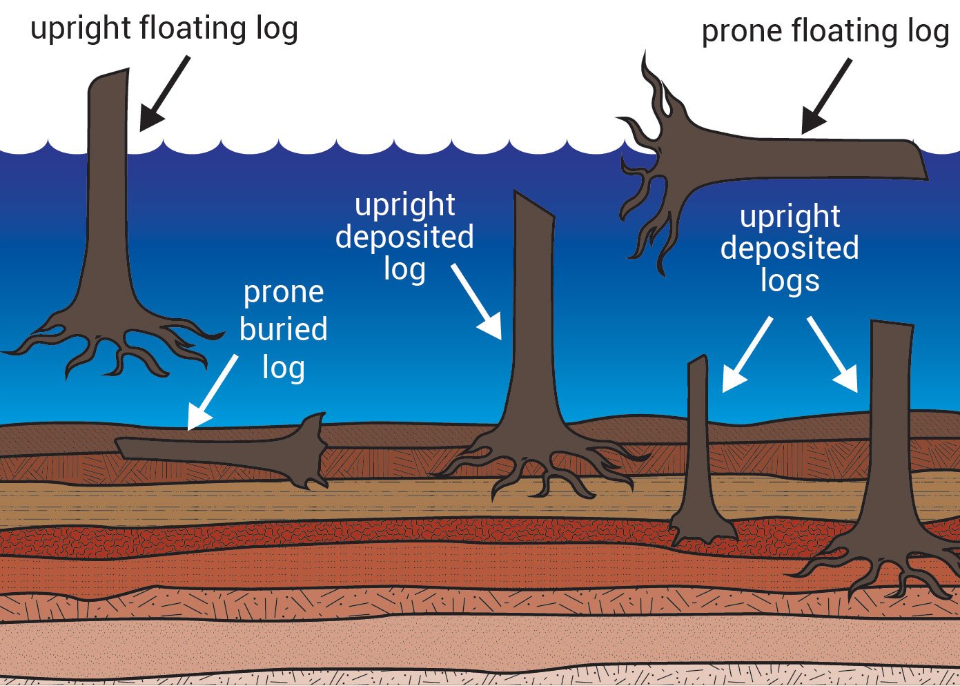
Surprisingly, as the logs became water-logged they tipped on their ends and floated vertically (figure 9). Eventually they sank to the bottom with their heavy root-end penetrating the sediment and peat layers there. The initial sediment deposited in the lake raised its floor by some 90 m (300 ft), and further sediments were deposited in the subsequent months and years. As more logs sank they formed a ‘forest’ of vertical logs with their roots buried in sediment at different levels on the bottom (figure 10). If someone saw this but did not know how it formed, then they might think multiple forests had grown in place and been successively buried. But such an interpretation would be wrong. The vertical ‘trees’ at the bottom of Spirit Lake were ripped up from one forest that was destroyed in one catastrophic event.
 |
 |
Trees were also engulfed by the landslide and carried kilometres down North Fork Toutle River. More than 30 years after the disaster, along the Hummocks Trail I saw many tree trunks still protruding from the ground. In the past, geologists routinely said vertical tree trunks entombed in sediment were buried where they were growing.4 That is what the interpretive signs at Specimen Ridge in Yellowstone Park used to say about the multiple layers of vertical tree trunks exposed there—that the forests grew and were buried multiple times over many tens of thousands of years. This time-frame clearly contradicted the biblical one. However, Mount St Helens has changed that thinking and the signs have been removed from Yellowstone. Geologists now know that trees can be transported into place by volcanic catastrophes and left sitting vertically, as we saw at Mount St Helens.
Catastrophic change in mindset
The devastating eruption of Mount St Helens in 1980 showed a lot about the effects of geological catastrophe. Features that geologists have traditionally thought needed long periods of time to form formed very quickly, within hours, days and weeks.
Yet, by volcanic standards, even in historic times, the Mount St Helens blast was relatively small, ejecting some 1 km3 (0.2 cubic miles) of ash. The eruption of Vesuvius in ad 79 was three times larger, Krakatoa in 1883 was 18 times bigger, and Tambora in 1815 was 80 times larger. The volume of lava in the Deccan Traps in India is some 5 million times more. These indicate that volcanic eruptions during Noah’s Flood were millions of times larger. When we consider the true immensity of the biblical cataclysm, and how it impacted the whole earth, Mount St Helens helps us envisage how Noah’s Flood explains the geology of the world, and how it happened so quickly.
Once we realize that the Bible is not mythological but records true events in history, we can approach its message with a new mindset. Then we are open to make new discoveries about our world and our place in it.

Mount St Helens reveals fatal radioactive-dating flaw
The May 1980 explosion blew 400 m (1,300 ft) from the top of the mountain, leaving a gaping, horseshoe-shaped crater. The eruption continued through the year, but by October the volcano had settled such that lava extruding from inside the mountain could collect in the crater (figure 11). By 1986 it had formed a dome 350 m (1,100 ft) high and up to 1,060 m (3,500 ft) in diameter. With a view to testing the accuracy of radioactive dating, geologist Steve Austin collected a sample of the new volcanic rock (called dacite) in 1992.1
All dating methods are based on assumptions because we can only measure the chemicals in the sample in the present. It is not possible to go back in time to measure what was in the sample when it formed, or to know what may have happened to the sample after that. The eruption of Mount St Helens provided a unique opportunity to test the dating methods because we know the actual time that the new lava dome formed.
After preparing a collection of different sub-samples, Dr Austin sent these to a reputable commercial laboratory to make measurements suitable for the potassium-argon method of ‘dating’. Some subsamples were prepared of the whole rock while others were selected to emphasize different minerals making up the rock. The ‘ages’ of some of the different sub-samples based on the potassium-argon method, applying standard dating assumptions, are shown in the table.

The calculated ages of the rock from the lava dome ranged from 350,000 years to 2,800,000 years, yet the rock had formed just 10 years before. Clearly the ‘age’ was vastly wrong. A key assumption of the potassium-argon method is that all argon escapes from the lava while it is still molten. In that case the ‘age’ would represent the time when the lava crystallized and the rock became gas-tight. But that assumption was wrong. The rock already contained lots of argon when it solidified and so it gave incorrect ‘dates’.
Some people have objected that the tests were inappropriate because the potassium-argon method only works on rocks that are millions of years old.2 However, the plus-and-minus range (±) against each result cancels that objection. This range indicates the precision of the laboratory measurement, and in every case the error range is much smaller than the calculated ‘age’. This shows that the argon measured was well within the precision of the equipment.
This rare opportunity to test radioactive dating on rocks of known age has demonstrated that the basic assumptions are not valid. Volcanic rock produced from this volcanic eruption already contained so-called ‘daughter’ isotope not produced by radioactive decay since the rock solidified. The tests have demonstrated that we cannot trust radioactive dating results on rocks of unknown age.
References and notes
- Austin, S.A., Excess argon within mineral concentrates from the new dacite lava dome at Mount St Helens volcano, J.Creation 10(3):335–343, 1996; creation.com/lavadome.
- Countering the critics: Radio-dating in rubble, Creation 23(3):24–25, 2001; creation.com/radio-dating-in-rubble.
The Hummocks demonstrate previously-unknown volcanic hazard
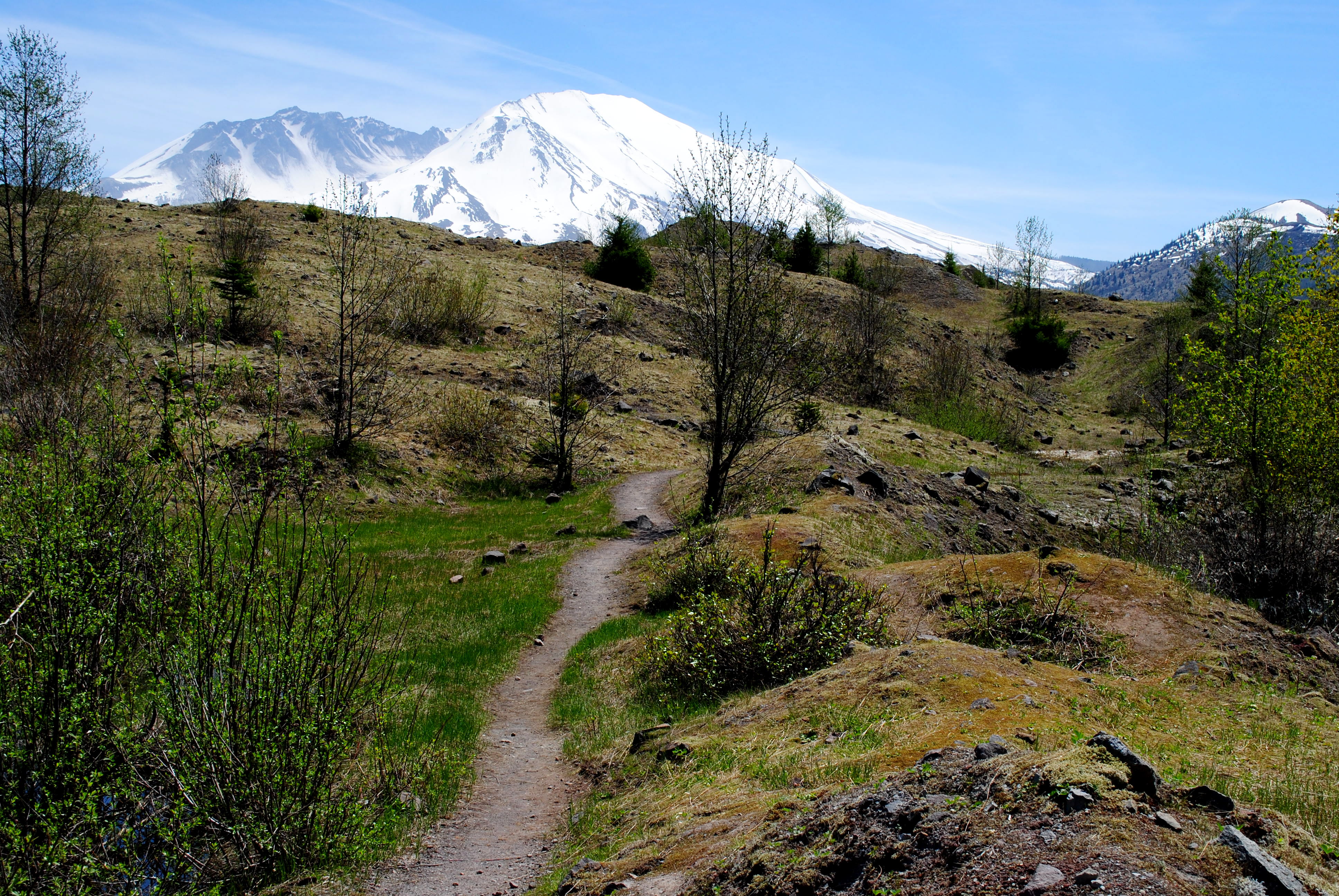

Mount St Helens was a geological disaster, and such events don’t happen every day. Unprecedented monitoring and observation of the eruption provided new insights into many geological features formed by catastrophe. One example is an uneven area of hills and depressions some 10 km (6 miles) northwest of the mountain called the Hummocks. Before Mount St Helens, geologists had noted similar mounds near other volcanoes, and thought they formed from glaciers or mudflows.
When I hiked through the Hummocks, the area was mostly vegetated with young trees, but there were also lakes, ponds, wetlands, and open spaces (figure 12). The gaping crater of Mount St Helens loomed in the distance. It was sobering to realise that the hummocky landscape was once part of the volcano. When it erupted, the whole side of the volcano collapsed, thrusting an enormous volume of rock, snow and ice down the mountain. The landslide careered under its own momentum, rafting chunks of volcano the size of small hills along the North Fork Toutle River, and shooting over undulations and ridges as if they did not exist. Altogether the avalanche travelled 22 km (14 miles) down the river valley and left some 50 m (150 ft) of debris in the area. If it had not been observed we probably would not connect the Hummocks with the volcanic eruption, or appreciate that the rock avalanche had travelled so far so quickly.
As a result of seeing the avalanche and carefully investigating the deposit, scientists now realise that hundreds of similar deposits at the bases of volcanoes around the world likely formed the same way. These include Mount Egmont, in New Zealand, where the debris avalanche travelled 30 km (19 miles). For Mount Shasta, California, USA, the debris avalanche travelled 50 km (30 miles). Thus, the Mount St Helens eruption has revealed a previously unknown hazard with global implications. Not only has the eruption revealed new geological hazards, but the blast has revealed other features that challenge widely held geological beliefs. New processes can shed light on geological features that have previously been wrongly interpreted, and this is especially relevant for understanding the impact of Noah’s Flood on the geology of our planet.
References and notes
- Morris, J., and Austin, S.A., Footprints in the Ash: The explosive story of Mount St Helens, Master Books, Green Forest, AR, pp. 50–55, 2003. See also: Walker, T., Geologic catastrophe and the young earth, Creation 32(2):28–31, 2010; creation.com/geologist-steve-austin. Return to text.
- Julien, P.Y., Lan, Y., and Berthault, G., Experiments on stratification of heterogeneous sand mixtures, J. Creation 8(1):37–50, 1994. Return to text.
- Oard, M.J. Ancient Ice Ages or Gigantic Submarine Landslides, Creation Research Society Monograph 6, Chino Valley, Arizona, 1997. Return to text.
- Sarfati, J., The Yellowstone petrified forests: Evidence of catastrophe, Creation 21(2):18–21, 1999; creation.com/yellowstone. Return to text.


Readers’ comments
Comments are automatically closed 14 days after publication.