

Mercator’s Projections
Mercator, the creationist whose map revolutionized navigation
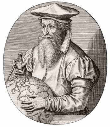
Few men have had as significant an effect on anything as Gerhard (or Geert) Mercator has had on navigation. He was born in 1512 at Rupelmonde (near Antwerp). His father died c. 1527, and his Uncle Gisbert became his guardian and sent him to a school at ’s-Hertogenbosch,1 in the Netherlands. This was run by the Brethren of the Common Life, and was “ranked with the finest secondary schools on the continent”.2 The Brothers “cultivated an intense, loving, and personal faith”,2 and also specialized in copying sacred texts. Thus Gerard learned penmanship and especially italic script, which he later used profusely to annotate his maps.
Name change to Latin
Young scholars of that era often Latinized their names, and Gerard Kremer chose to call himself Gerardus Mercator Rupelmundanus,3 under which name he enrolled at the University of Louvain, and received a Master of Arts degree in humanities and philosophy in 1532. These studies were based on the teachings of Aristotle: e.g. that all matter was composed of earth, air, fire, and water, that there was no divine purpose in the affairs of man or nature, and that the universe never had a beginning and would never end. This presented something of a crisis of faith for Mercator—not so much of his faith in the Bible, but in what he had been taught.
He corresponded with and then visited a group of Franciscan friars in Antwerp and Mechelen, which reinforced his strong Christian convictions. He later wrote: “When I saw that Moses’ version of the Genesis of the world did not fit sufficiently in many ways with Aristotle and the rest of the philosophers, I began to have doubts about the truth of all philosophers and started to investigate the secrets of nature.”4 Surely a commendable approach today for those who heedlessly imbibe the anti-God and anti-scientific philosophy of Darwinism.
Mercator’s travels also gave him a deep interest in geography as a means of explaining the world that God had created, so that “the making of maps … became not only a profession that promised him an adequate income, but a calling as well.”5

Marriage and map-making
By the time he was 24, Mercator was well versed in geography, astronomy, cartography and surveying, and had also become a highly skilled engraver, calligrapher, and scientific instrument maker. In 1536, he married Barbara Schellekens. They had three sons and three daughters. All three boys became mapmakers; the youngest, Rumold, supervised publication of Mercator’s world Atlas in 1595, after the death of his father.
Arrested for heresy
In 1544, the Catholic Inquisition charged 43 Louvain residents with ‘heresy’. Mercator was accused of ‘Lutheranism’, and of having written ‘suspicious letters’ to the friars at Mechelen.6 At the time, he was temporarily in Rupelmonde as executor of his recently deceased Uncle Gisbert’s estate. Nevertheless, he was declared a fugitive, arrested, and imprisoned in Rupelmonde Castle.
Despite a search by the authorities at Mechelen, no incriminating letters were found. Mercator’s friends at the University of Louvain petitioned strongly for his release, which finally happened after he had endured several months’ incarceration.

Mercator’s projection
In 1569, Mercator published the world map for which he is now famous, and which he titled (in Latin): “New and more complete representation of the terrestrial globe properly adapted for its use in navigation.” Instead of depicting the earth as a circle, Mercator’s new map was a rectangle 1.24 m × 2.02 m (~4 ft 1 in × 6 ft 7½ in). in which the northern and southern extremities extended the full width of the map, and so the lines of longitude were thus all vertical and parallel.
Land masses near the top and bottom of this map are distorted. The problem arises from trying to represent earth’s 3D global surface on a 2D plane surface. No matter how it is done, some feature of the globe gets distorted, e.g. on modern maps Greenland looks about the same size as Africa, but Africa is actually about 14 times larger.
The huge advantage of this map for seamen was that a course between any two places crosses all longitudes at the same angle, so sailors could chart their course on this map as a straight line (called a rhumb line or a loxodrome), and then simply sail one constant compass bearing along this line to eventually arrive at their destination.
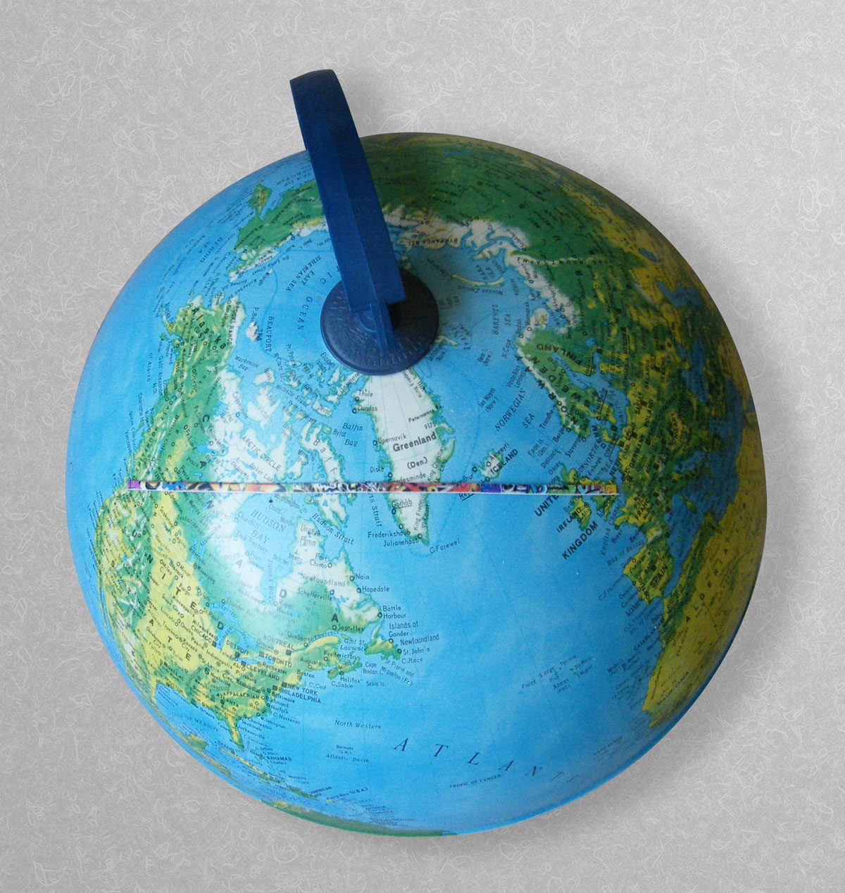
However, a rhumb line is not the shortest distance between any two places on the earth’s surface, which is a ‘great circle’ route.7 This is a straight line (i.e. ‘as the crow flies’) on a globe of the world, but is a curve on a Mercator map. On any great circle route (other than along the equator or North–South), the compass bearing constantly changes as the voyage proceeds. Hence navigators on ships sailing a great circle route had to make daily accurate determinations of their position so as to change their compass course accordingly. Inaccuracy could be disastrous and often was. Mercator’s projection is still used for virtually all nautical charts published today.
Mercator’s Atlas
In 1578, Mercator published updated versions of Ptolemy’s 27 2nd-century maps of the world, as a preliminary to his world Atlas, which he labelled “Cosmographic Meditations on the Creation of the World and the Shape of that which was Created”. This Atlas was published in three instalments: the first in 1585 with 51 maps, a second in 1589 with 23 more maps; the final one with all of these plus still more maps was published by his son, Rumold, in 1595, the year after Mercator died of a stroke aged 82.
Bible student
Mercator was a devout Christian, a Bible student, and a cogent creationist. In the 1560s, he produced a harmony of the Gospels, which he republished, enlarged, in 1592, and he also wrote a commentary on the first chapters of Romans. In his Atlas, he included a thesis of about 36,000 words,8 on the 1st chapter of Genesis. In this, he upheld that the triune God was “the Father, the logos or Son, and the Holy Spirit”. Opposing the Platonists whom he said, “posit that Intellect or Mind is the maker of the world”, he wrote: “Therefore let us give thanks to the one sole God, who is the beginning and creator and life-giver and preserver and the end of the work of the world, that he deigned to reveal to us the true fabric of the world, its beginning and the source of all philosophy and all truth, through Moses and the other prophets.”9,10
References and notes
- The city’s official name is a contraction of the Dutch des Hertogen bosch—‘the Duke’s forest’, after Henry I, Duke of Brabant. In speech, Dutch people usually abbreviate it further to “Den Bosch” (pronounced ‘demBOS’). Return to text.
- As quoted by Karrow, R.W., Commentary on Gerardus Mercator, Atlas sive cosmographicæ meditationes de fabrica mundi et fabricati fi gura, on which much of this article is based, see mail.nysoclib.org/Mercator_Atlas/MCRATS.pdf, pp. 3– 4. (Accessed March 17, 2015.). Return to text.
- I.e., Gerard Mercator of Rupelmonde. Kremer/Kramer/Krämer is of Germanic origin meaning ‘merchant’, which in Latin is mercator. Return to text.
- Mercator, G., Evangelicæ Historiæ: Quadripartita Monas Sive Harmonia Quatuor Evangelistarum (“Harmonization of the Gospels”), 1592, dedicatory letter. Quoted in Jean Van Raemdonck, Gerard Mercator: sa vie et ses oeuvres (1869), p. 25, footnote 2. Return to text.
- Ref. 2, p. 6. Return to text.
- Ref. 2, p. 10. Return to text.
- A great circle is a circle on the earth’s surface the plane of which passes through the centre of the earth. Aircraft pilots save fuel and time by flying great circle routes, unless impeded by high mountains, volcanic eruptions, bad weather, etc. Return to text.
- Titled “On the Creation and Fabric of the World”. Return to text.
- Ref. 2, pp. 47, 41, 42. Return to text.
- Mercator was, of course, limited to the narrow and speculative nature of the science of his day, e.g. Newton’s concept of gravity had not yet emerged, and he held some positions that CMI rejects. Return to text.


Readers’ comments
Comments are automatically closed 14 days after publication.