
Journal of Creation 14(2):14–17, August 2000
Browse our latest digital issue Subscribe
Only one Lake Missoula Flood
Click here for larger view
The Lake Missoula Flood was one of the largest floods in Earth history, the Genesis Flood being the largest, by far. The Lake Missoula Flood, which also has been referred to as the Spokane Flood or the Bretz Flood, possibly may be an analogue for the Genesis Flood. Analysing such a huge local flood may help us to comprehend the awesome power of the Genesis Flood.
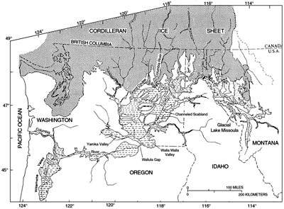
The Lake Missoula Flood occurred at the peak of the Ice Age when a proglacial lake1 in the valleys of western Montana, USA, broke through its ice dam and drained in about 48 hours (Figure 1).2–5 It rushed through eastern Washington and down the current path of the Columbia River at up to 35 m/sec with a discharge about 15 times the combined flow of all the rivers of the world.6,7
Glacial Lake Missoula had a volume of about 2,200 km3 based on the many shorelines observed in the western mountain valleys of Montana (Figure 2). It was ponded behind an ice dam at least 700 m thick against a lobe of the Cordilleran Ice Sheet that occupied northern Idaho. The Lake Missoula Flood is believed by some geologists to have carved out the Grand Coulee and Dry Falls in north central Washington.8 The Grand Coulee is a gorge about 80 km long and up to 300 m deep. Dry Falls sits at the head of a gorge about 100 m deep and 5 km long about midway in the Grand Coulee.
Controversial history
The concept of the Lake Missoula Flood has had a controversial history. Based on geological observations back in 1923, J. Harlen Bretz postulated a gigantic flood in eastern Washington from an unknown source.9,10 This started a storm of controversy that lasted about 40 years. The idea of the Lake Missoula Flood was rejected because it seemed too close to the biblical Flood. Victor Baker states:
‘Bretz’ flood theory was so despicable that even circular reasoning could be employed to erect an alternative hypothesis. … One cannot but be amazed at the spectacle of otherwise objective scientists twisting hypotheses to give a uniformitarian explanation to the Channeled Scabland. Undoubtedly these men thought they were upholding the very framework of geology as it had been established in the writings of Hutton, Lyell, and Agassiz.’ 11
Creationists should not be surprised if uniformitarian geologists see no evidence for the Genesis Flood.
Multiple flood explanations
Bretz’ ‘outrageous hypothesis’ was vindicated in the 1960s when more than just a few geologists actually examined the area. The evidence was obvious and overwhelming. Nevertheless, not just content with one gigantic flood, uniformitarian geologists could not help but postulate more than one. The Lake Missoula floods then became uniformitarian events.
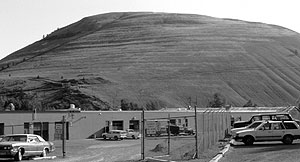
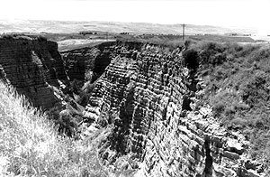
The tradition started with Bretz himself, who at age 70 returned for fieldwork in eastern Washington, and postulated possibly up to seven floods.12 Up until 1980, most investigators postulated one or a few floods. In that year, Richard Waitt proposed a succession of about forty Lake Missoula floods.13 His evidence was primarily based on a series of about 40 rhythmites in Burlingame Canyon within the Walla Walla Valley of southeast Washington (Figure 3). This valley is located in a backwater basin that was inundated after the flood water ponded behind a constriction at Wallula Gap, forming a lake about 250 m deep. Waitt postulated that each rhythmite was laid down by one Lake Missoula flood. He based his conclusion especially on the existence of a supposedly subaerial ash layer on top of the thirteenth rhythmite from the top.
In 1986, the number of floods jumped to about 90, based on 89 rhythmites separated by what are believed to be varves, which were discovered in Sanpoil Valley in northeast Washington.14 Each rhythmite was related to one Lake Missoula flood. A total of 3,000 varves were claimed, intermingled within the flood rhythmites. So the whole sequence of about 90 Lake Missoula floods was thought to have occupied a period of 3,000 years. This is more than ten times too much time for the deglacial phase of the post-Flood Ice Age, based on melting equations over snow and ice during a cooler ice age climate.15
Only one flood
Lately, more geologists are swinging full circle back to fewer, or even one, Lake Missoula Flood. Gary Smith disputed some of the evidence used to argue that each rhythmite was a separate Lake Missoula flood.16 Instead, he claimed that 2 to 9 rhythmites make up each flood for a total of about 20 Lake Missoula floods, which rather confuses the matter, especially since at any one location each rhythmite is similar. Recently, a team of eight investigators from the University of Alberta in Edmonton have re-evaluated the field evidence for the number of floods and have concluded that there was only one flood from glacial Lake Missoula, although they postulate that other floods from British Columbia carved the Grand Coulee.17 The latter postulate has some merit and needs to be evaluated further.
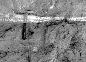
Shaw et al.18 argue that the volcanic ash layer in the Burlingame Canyon was deposited underwater because the ash layer was intercalated with silt and sand layers, which suggests the simultaneous deposition of both the ash and suspension deposits. This is a conclusion I arrived at when I examined the deposits, including the ash layer (Figure 4).
Shaw et al. provide further evidence at Burlingame Canyon and elsewhere along the flood path for just one gigantic flood. First, the rhythmites fine upwards from 2 m thick to about 10 cm thick, more indicative of one flood that waned with time. Second, minor scours (maximum depth 80 cm) are confined to the basal units. If each rhythmite were a separate flood, the scours should be all through the rhythmites. Third, unique clastic dikes, which look like sand and silt rhythmites, are cut through numerous beds and sometimes through the whole sequence. This indicates that the dikes were formed under pressure temporarily in excess of lithostatic pressure, and that most have formed after deposition of the entire sequence. Otherwise each bed would have its own set of dikes, generally separated from other rhythmites. Shaw et al. postulate that the rapid draining of the ponded lake, while the groundwater head at depth in the sediments remained high, caused explosive release of water that formed the clastic dikes.
And finally, the 89 rhythmites in northeast Washington could not have been deposited by multiple Lake Missoula floods as postulated by Atwater14 because they do not contain any basalt clasts. Floodwater from a Lake Missoula flood would have had to traverse the northern edge of the Columbia River Basalts and would have carried abundant basalt clasts if they flowed north up the Sanpoil Valley. Since basalt clasts are not present, the rhythmites in Sanpoil Valley were clearly deposited by water flowing south, rather than north. Thus, the 89 rhythmites were not formed by multiple Lake Missoula floods, but most likely by melting pulses from the Cordilleran Ice Sheet to the north.
Rhythmites deposited rapidly
A recent observation of a catastrophic outburst flood (jökulhlaup) in Iceland provides further support for only one gigantic Lake Missoula Flood.19,20 Water from snow, melted by a subglacial volcanic eruption, burst from under the ice on November 5, 1996. The peak discharge was 45,000 m3/sec, which was only 0.2 % of the peak discharge of the Lake Missoula Flood. Iceland’s jökulhlaup lasted about 36 hours. During the later half of the flood, the water switched outlets causing the original outlet to act as a ‘slackwater embayment’. Besides crossbeds in the slackwater embayment, planar beds dipping at a low angle formed many normally graded rhythmites of fine gravel and coarse sand. Two hundred planar rhythmites and 100 prograding rhythmites formed a section 15 m thick in just 17 hours. That is one rhythmite every 3 to 4 minutes! Moreover, large rip-up clasts of bedded strata composed of stratified sand and gravel up to 3 m in diameter were emplaced within the rhythmites. I have observed rip-up clasts in a number of Lake Missoula Flood bars and slackwater deposits. Matrix-supported outsized clasts within the rhythmites are reminiscent of ‘dropstone varvites’ in claimed ancient ice age deposits.21
If the small Iceland flood can produce 15 m of rhythmites in a short time, the Lake Missoula Flood can certainly form rhythmites along the edge of its flow path with a maximum thickness at Burlingame Canyon of about 50 m. Baker and others had postulated that the rhythmites in the Lake Missoula Flood had been formed by multiple pulses or surges up slack water valleys within a single flood. Each surge spread a turbidity current-like deposit upvalley. The surges would be caused by the uneven discharge from multiple valleys being drained in western Montana and the multiple flood paths in eastern Washington that diverge and converge. The rhythmites in Iceland were deposited by repeated turbulent flow pulses, which supports the multiple rhythmite per flood conclusion of Shaw et al.17
The Lake Missoula Flood, as well as the much smaller Icelandic flood, may provide insight into the global Genesis Flood. For instance, landforms produced by the Lake Missoula Flood may provide an analogue for landforms produced by the Genesis Flood. We must be careful of the scale problem, however. Secondly, the rhythmites of the Icelandic and Lake Missoula Floods may provide insight on how turbulent flow pulses can lay down sedimentary layers rapidly. Third, the rapid erosion of approximately 200 km3 of loess and basalt from just one Lake Missoula Flood can help us better appreciate the catastrophic erosional processes of the Genesis Flood. These considerations need further exploration.
Acknowledgements
I thank Harold Coffin for sending me the article by Shaw et al. from Geology. I also appreciate the co-operation and encouragement of the Design Science Association of Portland, Oregon, for many field trips within the former path of the Lake Missoula Flood.
References
- A lake immediately in front of a glacier, or just outside the limits of an ice sheet. Return to text.
- Baker, V.R., Paleohydrology and sedimentology of Lake Missoula flooding in Eastern Washington, Geological Society of America Special Paper 144, Boulder, Colorado, 1973. Return to text.
- Baker, V.R. and Nummedal, D. (Eds.), The Channeled Scabland, National Aeronautics and Space Administration, Washington, D.C., 1978. Return to text.
- Baker, V.R. and Bunker, R.C., Cataclysmic late Pleistocene flooding from glacial Lake Missoula: a review, Quarternary Science Reviews 4:1–41, 1985. Return to text.
- Benito, G., Energy expenditure and geomorphic work of the cataclysmic Missoula flooding in the Columbia River Gorge, USA, Earth Surface Processes and Landforms 22:457–472, 1997. Return to text.
- Allen, J.E. and Burns, M., with Sargent, S.C., Cataclysms on the Columbia, Timber Press, Portland, Oregon, 1986. Return to text.
- O’Connor, J.E. and Baker, V.R., Magnitudes and implications of peak discharges from glacial Lake Missoula, Geological Society of America Bulletin 104:267–279, 1992. Return to text.
- Weis, P.L. and Newman, W.L., The Channeled Scablands of Eastern Washington—The Geologic Story of the Spokane Flood, 2nd Ed., Eastern Washington University Press, Cheney, Washington, 1989. Return to text.
- Bretz, J.H., Glacial drainage on the Columbia Plateau, Geological Society of America Bulletin 34:573–608, 1923.Return to text.
- Bretz, J.H., The Channeled Scablands of the Columbia Plateau, Journal of Geology 31:617–649, 1923. Return to text.
- Baker, V.R., The Spokane Flood controversy; in: Baker, V.R. and Nummedal, D. (Eds.), The Channeled Scabland, National Aeronautics and Space Administration, Washington, D.C., pp. 11,15, 1978. Return to text.
- Bretz, J.H., Smith, H.T.U. and Neff, G.E., Channeled Scabland of Washington: new data and interpretations, Geological Society of America Bulletin 67:957–1049, 1956. Return to text.
- Waitt Jr, R.B., About forty last-glacial Lake Missoula jökulhlaups through southern Washington, Journal of Geology 88:653–679, 1980. Return to text.
- Atwater, B.F., Pleistocene glacial-lake depostis of the Sanpoil River Valley, northeastern Washington, U.S. Geological Survey Bulletin 1661, Washington D.C., 1986. Return to text.
- Oard, M.J., An Ice Age Caused by the Genesis Flood, Institute for Creation Research, El Cajon, California, 1990. Return to text.
- Smith, G.A., Missoula flood dynamics and magnitudes inferred from sedimentology of slack-water deposits on the Columbia Plateau, Washington, Geological Society of America Bulletin 105:77–100, 1993. Return to text.
- Shaw, J., Munro-Stasiuk, M., Sawyer, B., Beaney, C., Lesemann, J.-E., Musacchio, A., Rains, B. and Young, R.R., The Channeled Scabland: back to Bretz? Geology 27(7):605–608, 1999. Return to text.
- Shaw et al., Ref. 17, p. 607. Return to text.
- Russell, A.J. and Knudsen, O, An ice-contact rhythmite (turbidite) succession deposited during the November 1996 catastrophic outburst flood (jökulhlaup), Skeidarárjökull, Iceland, Sedimentary Geology 127:1–10, 1999. Return to text.
- Snelling, A.A., Iceland’s recent ‘mega-flood’: an illustration of the power of Noah’s Flood, Creation 21(3):46-48, 1999. Return to text.
- Oard, M.J., Ancient Ice Ages or Gigantic Submarine Landslides? Creation Research Society Monograph 6, Chino Valley, Arizona, pp. 57–67, 1997. Return to text.
- Waitt Jr, W.B., Case for periodic, colossal jökulhlaups from Pleistocene glacial Lake Missoula, Geological Soc. of America Bulletin 96:1272, 1985. Return to text.

Readers’ comments
Comments are automatically closed 14 days after publication.