
Feedback archive → Feedback 2008
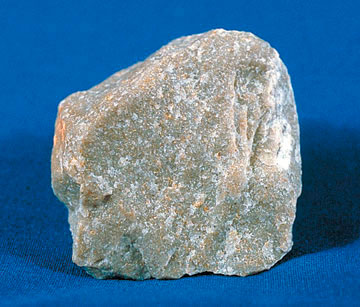
Quartzite gravel in soils
More evidence for Noah’s Flood
We received a comment about quartzites in soils (green text below) from Everett C of the USA in response to the article How landscapes reveal Noah’s Flood. Guest writer Michael J. Oard responds later in the article.
After receiving a BS in geology in 1975, I have worked for over 30 years as a soil scientist in North Carolina. Since becoming a creationist in 1990, I have seen what I take to be evidence for the Flood in the soils of the piedmont region of the state.
For instance, quartzite gravel, most of it rounded to some degree, can be found in soils that overlie any geology imaginable (but none of which includes quartzite). Often the gravel occurs at the base of the soil and unconformably above weathered rock (or saprolite). This saprolite is usually assumed to be the parent material of the soil. But the gravel may also be distributed throughout the soil or just in the topsoil layer.
Doing a web search for ‘gravel lines’ will reveal that they are found in soils all over the globe. In fact these gravel layers in the soil are so ubiquitous that some have even developed a new theory to explain their presence: the soil is a ‘biomantle’ (which is not an inaccurate concept of soil to a degree) where biological activity has caused the gravels to be lowered through the soil to their present position. Of course, this theory does not explain either their being a different rock type from the underlying bedrock or their roundedness.
In addition, in soil samples I collected from two piedmont counties and viewed with a microscope, the sand fraction consists dominantly of very angular quartz fragments that appear to have been crushed by abrasion. This would be consistent with a Flood origin. I have a copy of a one year-long experiment which showed that crushed quartz sand grains are very water soluble at a pressure of one atmosphere and normal surface temperatures (I can forward the reference if you so desire). The grains in my soil samples show no obvious evidence of chemical weathering, appearing freshly crushed. Such evidence (surface pitting and ‘spikelike projections’) was noted on some grains at the end of the above mentioned experiment. But it is interesting that there were also a few sand grains in some of my samples that appeared to have been significantly rounded by abrasion (frosted surface appearance).
It would seem that at least some so-called residual soils may have a sedimentary origin rather than the one assumed by uniformitarians, viz. by the weathering of the underlying rock.
My interpretation is that the power of the receding Flood waters carved essentially the piedmont topography that we see today. As the waters slowed, some of the sediment load was deposited over the very irregular hard rock surface. Floating vegetation could have stabilized the surface of the sediment (which contained the exotic gravels described above) allowing the soil to form rather quickly while the rock weathered beneath. This interpretation certainly can explain the very irregular depth of soil to saprolite over a very short distance (soil depth can vary by one to two feet within a similar horizontal distance).
Landscapes are indeed a relic of a catastrophic Flood event.
Everett C, NC, USA
Guest writer Michael J. Oard comments:
I would just like to add a comment on Mr C’s observations of resistant exotic gravels on the Piedmont, just east of the Blue Ridge Mountains. The Piedmont is a relatively flat, but locally dissected, erosion surface that stretches from New Jersey in the northeast to Alabama in the southwest.1 The western boundary is marked by the Blue Ridge Escarpment, which rises up 2,000 feet (600 m) above the piedmont in western North Carolina. In the east the Piedmont ends at what is called the Fall Zone at about 300 to 600 feet (90–180 m) above sea level. The nearly flat erosion surface of the Piedmont truncates a wide variety of igneous, sedimentary and metamorphic rocks dipping at various angles, leaving behind hundreds of what are called monadnocks or erosional remnants, like Stone Mountain Georgia. From a Flood geology point of view, the piedmont would have been carved by the receding floodwater draining off the rising continents.2
Such flat or nearly flat erosion surfaces would by typical of the Sheet Flow Phase.3
In that context, it is no surprise to find gravels that formed from resistant rocks, like quartzite, spread far from their source in the Appalachian Mountains onto the Piedmont. There are a number of reports of resistant gravels that are mostly capping the highest terrain of the Piedmont as well as the coastal plain to the east.4,5,6,7
In fact, resistant rocks are spread far to the west of the Appalachian Mountains and are called the Lafayette Gravel.8,9,10,11 Also, gravels are spread south of the Appalachians, for instance up to 1000 km into the subsurface of the Florida Keys.12 Such long distance travel of resistant rocks is typical of the mountainous areas of western North America and is one of many evidences from the field of geomorphology for the runoff of the floodwaters.2
References
- Steward, K.G. and Roberson, M.-R., Exploring the Geology of the Carolinas: A Field Guide to Favorite Places from chimney Rock to Charleston, The University of North Carolina Press, Chapel Hill, NC, pp. 3–4, 2007. Return to text.
- Oard, M.J., Flood by Design: Receding Water Shapes the Earth’s Surface, Master Books, Green Forest, AR, 2008. Return to text.
- Walker, T., A biblical geologic model; in: Walsh, R.E. (Ed.), Proceedings of the Third International Conference on Creationism, technical symposium sessions, Creation Science Fellowship, Pittsburgh, PA, pp. 581–592, 1994. Return to text.
- Schlee, J., Upland gravels of southern Maryland, Geological Society of American Bulletin 68:1371–1410, 1957. Return to text.
- Owens, J.P. and Minard, J.P., Upper Cenozoic sediments of the Lower Delaware Valley and the Northern Delmarva peninsula, New Jersey, Pennsylvania, Delaware, and Maryland, U.S. Geological Survey Professional paper 1067-D, U. S. Government Printing Office, Washington, D.C, 1979. Return to text.
- McCartan, L., Tiffney, B.H., Wolfe, J.A., Ager, T.A., Wing, S.L., Sirkin, L.A., Ward, L.W. and Brooks, J., Late Tertiary floral assemblage from upland gravel deposits of the southern Maryland Coastal Plain, Geology 18:311–314, 1990. Return to text.
- Pazzaglia, F.J., Stratigraphy, petrography, and correlation of late Cenozoic middle Atlantic Coastal Plain deposits: Implications for late-stage passive-margin geologic evolution, GSA Bulletin 105:1617–1634, 1993. Return to text.
- Potter, P.E., The petrology and origin of the Lafayette gravel Part I. mineralogy and petrology, Journal of Geology 63:1–38, 1955. Return to text.
- Potter, P.E., The petrology and origin of the Lafayette gravel Part II. Geomorphic history, Journal of Geology 63:115–132, 1955. Return to text.
- Autin, W.J., Burns, S.F., Miller, B.J., Saucier, R.T. and Snead, J.I., Quaternary geology of the Lower Mississippi Valley; in: Morrison, R.B. (Ed.), The Geology of North America, Volume K-2, Quaternary Nonglacial Geology: Conterminous U.S., Geological Society of America, Boulder, CO, pp. 547–582, 1991. Return to text.
- Bresnahan, R.P. and Van Arsdale, R.B., Denudation of the Pliocene-Pleistocene upland gravel in the upper Mississippi Embayment and its structural implications, Geological Society of America Abstracts with Programs, North-Central Section, 38th annual meeting, Geological Society of America, Boulder, CO, 36(3):47, 2004. Return to text.
- Froede Jr, C.R., Neogene sand-to-pebble size siliciclastic sediments on the Florida Peninsula: sedimentary evidence in support of the Genesis Flood, Creation Research Society Quarterly 42(4):229–240, 2006. Return to text.
Readers’ comments
Comments are automatically closed 14 days after publication.