

Journal of Creation 20(1):64–71, April 2006
Browse our latest digital issue Subscribe
Response to the post-Flood lake model for the Green River Formation
Lake paleoenvironmental signatures, as discussed by John Whitmore, are equivocal and thus cannot be considered as valuable as the geomorphological evidences. The exploded fish and caddis fly burrows are challenging to a Flood interpretation, however, other features of the fossil fish and caddis fly burrows are anomalous for a post-Flood lake. An early Flood timing can explain many of the features interpreted to be from a post-Flood setting, such as bird and mammal tracks, raindrop impressions, and mudcracks. Furthermore a case can be made for the inorganic deposition of ‘stromatolites’, and ‘evaporites’ claimed in the Green River Formation (GRF) have anomalous features for a post-Flood lake. A Flood model can explain the deposition and features of the GRF.
I thank John Whitmore for systematically presenting the case for the post-Flood lake model of the Green River Formation (GRF).1 There are many challenges in explaining features of the rocks and fossils in a Flood model, no matter what the supposed geological age. In thinking about the challenges of explaining the GRF, as well as the associated formations, from a Flood point of view, there will continue to be mysteries. We still don’t know enough about the details of the Flood to provide reasonable answers to some challenges. Often times, we can find features similar to the GRF in other formations that practically all creation geologists would believe are from the Flood, and in that way lend credence to a Flood mechanism.
I compare the problem to an explosion. When looking at the debris from long distance, it looks like an explosion occurred. But if we would go up and examine the debris close up, we may ask ourselves: how could that particular pattern occur in an explosion? It is the same with the Flood. The big picture of the rocks and fossils shouts a global Flood, but on the small or regional scale, we have much trouble seeing how the area relates to the Flood. Clearly, we need much more research.
With that caveat I will attempt to provide reasonable suggestions to some of the questions that Whitmore poses in the general order he presented them. I will not be able to do complete justice to Whitmore’s challenges, since many of them would require long research projects with more in-depth analysis. I also won’t comment on what seems like features that can form in either model, such as ripple marks and flat pebble conglomerate, but will stick to the major challenges.
Lake paleoenvironmental signatures?

Figure 24. Swiss Valley Bar is a large basalt-boulder gravel bar
from the Bonneville flood. It is located down from a bend in the Snake River, near
Hagerman, southern Idaho. (click image for larger view)
* Figures are numbered continuously through all the articles in this forum.

Figure 25. Lake Bonneville shorelines along the lower slope of the mountains, with a perched delta out from the little valley just right of centre. View east from junction of Interstate 15 and Highway 91, Utah. (click image for larger view)

Figure 26. Shorelines from an Ice Age pluvial lake in south-east Oregon (near the base of the hill). (click image for larger view)
Whitmore lists quite a number of lake paleoenvironmental signatures that, when added up, seems like a good case for a post-Flood lake, although dated as Eocene within the uniformitarian geological column. I appreciate Whitmore focusing on the physical evidence and not where the GRF fits into the geological column.
I agree that there would be lakes within enclosed basins right after the Flood, such as pluvial Lake Bonneville, which was about 245 m deeper and 8 times the size of Great Salt Lake. Furthermore, Lake Bonneville persisted late into the time of the Ice Age because shorelines have been etched on a terminal moraine at the mouth of Little Cottonwood Creek and Bells Canyon, south-east of Salt Lake City.2 The overflow of Lake Bonneville through Red Rock Pass in south-east Idaho also caused the Bonneville Flood, which is evident in southern Idaho near the Snake River (figure 24*).3 Lake Bonneville left obvious lake features such as distinct shorelines along the mountains and hills around Great Salt Lake (figure 25). There were quite a few other lakes in the Great Basin of the south-west USA after the Flood, and these also have surviving shorelines on the hillsides (figure 26). Pluvial Lake Lahontan in western Nevada not only has remnant shorelines, but also rounded beach gravels and numerous near-shore constructional features.4 There are also large deltas with coarse gravels at the mouths of canyons coincident with the shorelines.
How well do the suggested lakes represented by the GRF compare with Lake Bonneville and other pluvial lakes that were just to the west and would have occupied the same time in the post-Flood period? Do we see shorelines and high deltas associated with the GRF? Do we see any evidence that the postulated lakes overflowed over low ridges? We see signs of huge erosion in the basins containing the GRF. Do we see evidence of such erosion in any of the post-Flood pluvial lake basins during the Ice Age? Are there any subtropical or tropical fish associated with any of these pluvial lakes? Although a detailed study is needed, I would lean that the putative lakes that deposited the GRF are not analogous to the Ice Age lakes.
Uniformitarian scientists claim there commonly were lakes throughout the geological column based on a number of criteria.5,6 Besides many Tertiary lakes mapped in the western United States, there are also supposed to be extensive pre-Tertiary lake sediments along the continental divide and high plains.7 They include the mountain valleys of south-west Montana as well as the high plains of central Montana. I have great difficulty envisioning the sedimentary rocks in these areas in Montana as from ancient lakes. The above editors and authors list many criteria for identifying a lake, based of course on uniformitarian ideas, but the criteria have many complications and the data are contradictory. The main criterion seems to be the fossils.8 Selley believes non-marine fossils and low energy deposits, especially ‘varves’ or rhythmites, are particularly diagnostic of an ancient lake.9 However, we would expect a lot of non-marine fossils and thin-bedded rhythmites associated with the Flood. Guy Berthault has shown that thin laminites or rhythmites, even varve-like, can form rapidly in currents or even in still air when the particle sizes in the material are different.10 Settling of various types of particles with organic matter during the Flood, with or without currents, could be the explanation of the fine layering of the GRF.
Picard and High focus on three ancient lakes, including the GRF which they believe represents strong evidence for a lake.11 They also consider the Lockatong Formation of New Jersey and Pennsylvania and the Popo Agie Formation of Wyoming as good examples of ancient lakes. The sedimentary rocks of the later two are dated as Late Triassic within the uniformitarian geological column, so most creationist would place them within the Flood. Selley also believes that other ancient lake deposits are similar to the GRF, especially the Triassic Lockatong Formation in the Newark trough in the eastern USA. Like Fossil Basin, the Lockatong Formation has coarse sediments grading into finer sediments toward the middle of the basin, at least on the western side.12,13 I believe we need an in-depth study of all these claimed lakes to see how well they really compare to modern lakes, and to see how the Flood can duplicate their features.
With regards to the bullseye pattern as evidence for a paleolake, I found it interesting that Picard and High believe that the GRF in Utah conformed to an ideal pattern for a lake vertically but did not form a bullseye pattern of coarse sediments along the edge grading to finer sediments in the middle.14 So, although Fossil Basin has a bullseye pattern of sedimentation, the other basins containing the GRF apparently do not have an ideal pattern.

Figure 27. Quartzite terrace in background with lag of well-rounded quartzite boulders in the foreground in eastern Fossil Basin. Quartzite boulders have diameters up to 60 cm, a few percussion and pressure solution marks were observed. (click image for larger view)
It seems to me that many of the other variables used to infer a lake origin for the GRF are equivocal. For instance, cross-bedded sandstones at the edge of Fossil basin are not necessarily diagnostic of a delta. If these sandstones represent a delta, I would expect a fair amount of gravels associated with the sands. The coarse gravel associated with the GRF that I saw, the quartzite cobbles and boulders, generally lie on top of the GRF forming a lag deposit or even a terrace (figure 27).
If these large basins truly represent post-Flood lakes, there are numerous questions to ask. The requirements for the formation of the geologically rare oil shale are difficult to fulfill.15 How would the huge amount of organic matter in the form of kerogen accumulate in these lakes in a few hundred years after the Flood? Do other Ice Age lakes have abundant kerogen? Where do the massive amounts of carbonates found in the sediments originate after the Flood?
It is now generally assumed that the lakes that formed the GRF were mostly shallow and dried out at times forming ‘evaporites’. How would the great volume of ‘evaporites’ form in such a short period after the Flood? Should we not see evidence within the GRF ‘evaporites’ for rough surfaces, solution collapse features, and other deformation features, as seen on many playa lakes today?16
In the shallow lake/playa model, precipitation (rainfall, snow, etc.) must have been light in the area, which is difficult to envision for a few hundred years after the Flood.17 Light precipitation also means light denudation of the surrounding mountains. How, then, could thousands of metres of sediment accumulate over such a widespread area in such a short time after the Flood?
I would expect to see a fair number of alluvial fans along the edge of the lakes within the lake sediments. Are there alluvial fans associated with the GRF?
What does the paleontology tell us?
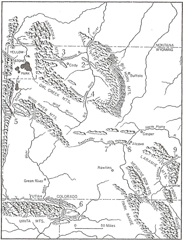
Figure 28. Map showing the Green River water gap through the Unita Mountains in the south-west portion of the picture.21 There are quite a few other water gaps in Wyoming and vicinity which are also shown on the map (from Thornbury).21 (click image for larger view)
Freshwater fish are considered one of the evidences of an ancient lake. However, it is quite likely that the pre-Flood oceans were far less salty than the oceans today, since much of the salt in the oceans today likely originated from the Flood. So freshwater fauna alone cannot be used as evidence of a post-Flood lake. Terrestrial plants also are not diagnostic of a continental environment.18 Furthermore, it does not seem that the fish in the GRF are strictly freshwater.19 There seems to be types of organisms in the GRF that predominate in marine waters, such as stingrays, dogfish, herring, a marine sand fish and sponge spicules.20
I don’t believe that the number of types and the variable number of fossil fish in the basins are evidence against the Flood and for a post-Flood lake. It seems that there should be more similarities in species between basins, if the GRF represents post-Flood lakes, because one would expect river or stream connections between the lakes. For instance, I would expect a connection between ‘Fossil Lake’ and ‘Lake Gosiute’ just to the east. In fact, the Greater Green River Basin is currently connected to the Uinta Basin by the Green River. Wouldn’t these two basins have been connected by a river when lakes supposedly filled these basins after the Flood?
If there was not a connection between ‘Fossil Lake’ and ‘Lake Gosiute’ during the time of the deposition of the GRF, then how did the Green River water gap form through the Uinta Mountains between the basins after the Flood? On the north side of the Uinta Mountains, the Green River at first runs eastward parallel to the east-west Uinta Mountains, then turns right and flows through hard quartzite in the core of the Uinta Mountains and into the Uinta Basin (figure 28).21 The river should have gone more easily around to the east of the Uinta Mountains when the basin fill sediments were thicker. Water gaps were more likely formed during the Channelized phase of the Retreating Stage of the Flood.22 Evidence that it takes a flood to form a water gap is shown by the Lake Missoula flood overtopping a ridge and cutting a new 150-m deep canyon that is now occupied by the Palouse River (figure 29).23,24 Another consideration is that the GRF and associated formations have been deeply cut by the Green River, indicating that the GRF was likely deposited before the formation of the water gap, which very likely formed during the Genesis Flood.
Credit: Image by Mark Wolfe
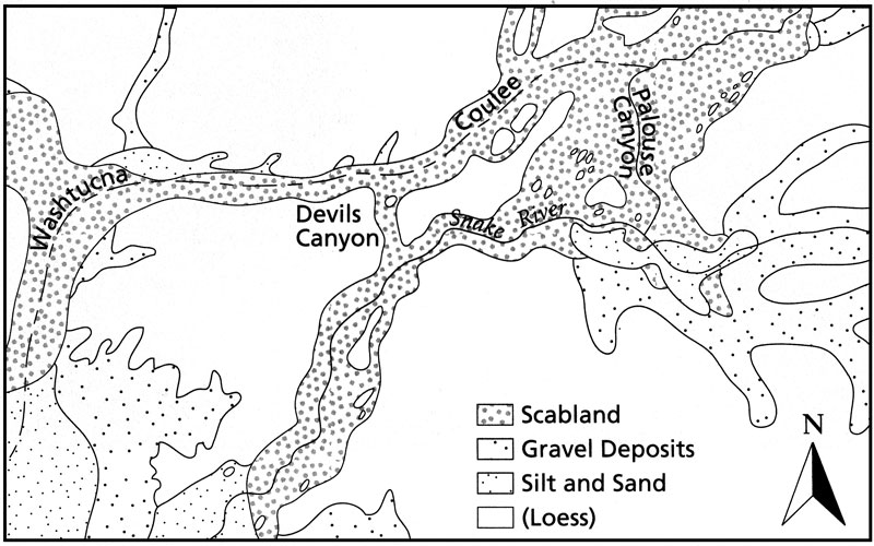
Figure 29. Map of ridge between Washtucna Coulee and the Snake River, south-east Washington, USA, which was breached to a depth of 150 m at two locations, by the Lake Missoula flood. The Palouse River flowed down Washtucna Coulee before the flood but after the flood ended up taking a left-hand turn, flowing into the Snake River.73 (click image for larger view)
Grande points out that the number of fish species in the GRF is anomalously low when compared to modern tropical African lakes.25 He has a table that shows only 15 species in ‘Lake Gosiute’ and 11 species in ‘Lake Uinta’. This is anomalous and certainly not expected for post-Flood lakes. Another anomaly is Bradley’s observation that there are no diatoms in the GRF.26 Diatoms are ubiquitous in modern fresh to marine waters, as Picard and High state, ‘Diatoms have adapted widely to virtually all types of water’.27 Moreover supposed freshwater diatoms can handle a wide range of salinities, and they are common in the western United States since the Eocene of the geological timescale.28 One would expect a great number and variety of diatoms in the GRF.
The presence of exploded, disarticuled, and partially decayed fish on a number of horizons is most interesting and forms a significant part of Whitmore’s excellent Ph.D. thesis.29 Whitmore states that such observations indicate shallow water and protracted deposition. This is challenging to a Flood interpretation, but I will attempt to focus these observations into a Flood model in the last section.
Are ‘stromatolites’ in sedimentary rocks biological?
Stromatolites are said to be abundant in the GRF, providing one of the evidences of a post-Flood lake. However, creationists should question whether most, if not all, stromatolites in the sedimentary rocks are biological. Why?
First, ‘stromatolites’ in the rocks are generally unlike those observed today in such hot environments as Bermuda and Western Australia.30 Stromatolites or stromatolite-like mats or bioherms also form in various freshwater environments.31 The freshwater forms appear to be different from the structures I saw in the GRF. Second, there is very little evidence of organic matter or structures associated with stromatolites in the rocks.32,33 Third, practically all the fossil ‘stromatolites’ are in carbonates.32,34 This is quite unlike modern stromatolites, which are found in a variety of sedimentary environments, and bind all types of sediments, not just carbonates.35 Fourth, ‘stromatolites’ in the rocks can be widespread over tens of kilometres while those today are more local.36 Fifth, ‘stromatolites’ are not only found in rocks that some creationist think are post-Flood as well as in the Precambrian that some creationists believe are pre-Flood,37 but also they are found in Phanerozoic carbonates38,39 that practically all creationists would believe are Flood rocks. Although not nearly as abundant as in Precambrian rocks, stromatolites are not rare in Paleozoic and Mesozoic carbonates, especially early Paleozoic.40 How are Paleozoic ‘stromatolites’ laid down in the Flood to be explained? If some ‘stromatolites’ are from the Flood, and there is not enough time for them to develop, why not include all or most all ‘stromatolites’ in sedimentary rocks as non-biological from the Flood, especially when they are unlike modern stromatolites?
It seems that the origin of these unique structures in carbonates were assumed organic before modern (though dissimilar) examples were found.41 It seems that there has been a bandwagon effect ever since. However, even some evolutionists have expressed uncertainty over the biological origin of stromatolites or at least some stromatolites in sedimentary rocks.42–44 The big picture within the Flood model indicates a non-biological origin for most, if not all, of these banded structures. I believe we should be looking for a physico-chemical effect within carbonates, possibly unique to the Flood.
What about large agglomeration of caddis fly cases?
Calcified caddis fly larval cases (figure 21) are claimed for a number of areas, mainly along the northern margin of the Green River Basin.45 They indeed look like organic structures, and Klevberg (personal communication) acknowledged from the samples in my possession that the tubes do look like caddis fly cases. So, I suggest that these structures are indeed caddis fly cases. A biological interpretation goes along with the observation by Bradley that some caddis fly cases in the GRF are lined with ostracode valves, commonly only one shell thick,46 which is likely a result of biological activity.
However, Klevberg and I noticed a few strange relationships compared with caddis fly cases in lakes and streams today. First, the GRF cases are found within circular carbonate mounds, interpreted as stromatolites, including along a 70-km-long horizon in the northern Green River Basin.47 There does not appear to be any modern analogue for this kind of behaviour by caddis flies.48 Caddis fly cases within ‘stromatolites’ may be the reason why some ‘stromatolites’ have borings into them.49 Why would caddis flies prefer to lay their eggs in the centres of ‘stromatolites’?
Second, it is odd that many hundreds of cases seem to be built right on top of each other, as if caddis flies always chose the same location to lay their eggs and build their cases.50 Klevberg (personal communication) relates how he has observed individual caddis fly cases scattered in a stream. One would expect the same scattering of cases below wave base along a lake. Why should they be so bunched together by the thousands?
Third, there does not seem to be many other types of insect evidence around, which I would have expected near the shoreline of a large post-Flood lake and also reported at modern locations where caddis flies live.51 These unusual circumstances make me realize that we need more research on caddis flies and their cases. The caddis fly cases seem at first glance to support a post-Flood lake environment, but it may be that the unusual activity by caddis flies may offer support for unique biological activity in the Flood (see last section below).
Tracks, bird bones, raindrop impressions, mudcracks and other special features
There are indeed tracks of birds and mammals and probably raindrop impressions near Soldier Summit, along the south-west edge of the Uinta Basins.52,53 ‘Flamingo nests’ are also claimed,54 as well as mudcracks and other special features. Tracks of land animals are the sign of live animals that in a Flood context should have been dead by Day 150 of the Flood (Genesis 7:20–24). Therefore, it looks like much of the tectonics, sedimentary rock deformation and basin fills in the central Rockies were actually deposited before Day 150. This goes along with a previous hypothesis from other areas of the western United States, based on mammal tracks and the pattern of erosion.55 I have been torn between where the GRF fits into the Flood, but the above is strong evidence for the first 150 days. This implies that practically all of the sediments in this area of the Rocky Mountains and high plains, even the Cenozoic sediments, are from early in the Flood. The Retreating Stage of the Flood after Day 150 would then be an erosional period for this area. It stands to reason that the sedimentary rocks still remaining after this great erosion would have been deposited before Day 150 in the Flood.
These deductions undoubtedly upset the ideas of some who believe that the geological column is a nice linear progression of the Flood, but with a compressed timescale. However, there is no theoretical reason to believe in such a linear pattern. In fact, because the greatest disruption occurred during the first 150 days, probably more so during the first 40 days, it makes more sense that the greater volume of sedimentation and tectonics over the currently high areas of the western United States occurred early in the Flood. In other words, Flood sedimentation was highly nonlinear with much more deposition early in the Flood. The record of the Retreating Stage of the Flood would mostly be a record of massive erosion of currently high altitude areas during late-Flood uplift with redeposition along the continental margin or unfilled basins on the continents, such as the Lower Mississippi River Valley.56
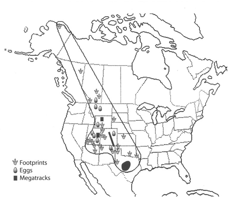
Figure 30. Dinosaur tracks, eggs and megatrack sites on postulated strip of land or series of shoals in western USA, generally parallel to the crest of the Rocky Mountains. Such a scenario can also account for mammal and bird tracks, bird nests, mudcracks and raindrop impressions in the Green River Formation. (click image for larger view)
This brings up the question of how tracks, raindrop impressions and other special features that indicate exposed land could have been formed on Flood sediments early in the Flood. I believe it is the same principle that can account for dinosaur tracks, eggs and unique features of some bonebeds in the Rocky Mountain region and the high plains, which I previously reported (figure 30).57 In areas of rapid sedimentation, the distance between the water surface and the bottom will become less and less. Then fluctuating sea level at numerous temporal scales would briefly expose the newly-deposited Flood sediments during a relative drop in local or regional sea level. There are at least four reasons why sea level would fluctuate during the early part of the Flood: (1) tectonics, (2) tsunamis, (3) tides on a mostly flooded Earth and (4) the dynamics of shallow Flood currents, less than 1,000 metres deep, on submerged continents at least 2,500 kilometres wide.58
The fourth mechanism requires a little explanation. Simulations of a totally flooded Earth with the water at rest show that water currents of 40 to 80 m/sec develop within weeks on shallow continents due to the spin of the earth, or the Coriolis force. These currents had ‘troughs’ and ‘ridges’ just like the jet stream in the atmosphere when looking down at the earth. Interestingly, the water piles up in the ridges and drops as much as 1,000 m in the troughs, intersecting the bottom. Furthermore, the pattern of troughs and ridges moves slowly, similar to the jet stream in the atmosphere. Such a pattern would expose freshly laid Flood sediments in the Flood current troughs that could remain exposed for many days, allowing tracks, eggs, nests, raindrop impressions, mudcracks and other special features to be produced—all early in the Flood. Birds, mammals and insects could have embarked on the temporarily exposed land from floating mats of vegetation or from higher ground not yet inundated by the floodwaters. Such a scenario can also explain orientated bird bones that provide evidence for a shoreline.59 Cracks that look like desiccation cracks can also form underwater, and it is often difficult to tell the difference between underwater synaeresis cracks or subaerial desiccation cracks.60,61
Geochemistry
Although trona cannot precipitate from standard seawater, we must remember that the floodwaters cannot be characterized as either ‘freshwater’ or ‘marine’ in today’s sense. So the presence of trona is not evidence against a Flood deposition and in favour of a post-Flood lake evaporite.
However, there are anomalies associated with the GRF ‘evaporites’ that militate against a lake environment. As Whitmore stated, there is no gypsum (or anhydrite) in the GRF.62 From a quick check of modern saline deposition in lakes, gypsum is a common mineral.5,6 Although a possible indicator of a marine environment, halite is also frequently found in modern lacustrine deposits, such as Lake Eyre, Australia.63 There are also very thick deposits of halite, up to 2.5 km, in Cenozoic deposits, including Miocene and Pliocene, in the western USA Basin and Range that are claimed to be nonmarine.64 It seems to me that these halite deposits are more indicative of Flood deposition, and that the Flood/post-Flood boundary is in the late ‘Cainozoic’ just to the west of the GRF. So, the rarity of halite in the GRF is not diagnostic. Hardie sums it up:
‘The majority of modern non-marine saline lake concentrated brines are, like seawater, NaCl-rich … The most common saline minerals in non-marine evaporite deposits are, like those of marine evaporites, halite and gypsum (and/or anhydrite) … .’65
The geochemistry of the GRF is unusual; the rocks are complex and present many problems.66,67 There is the problem of the origin of dolomite, which usually is precipitated, if primary, in hot water.68 Even the dolomitization of limestones (secondary dolomite) occurs at elevated temperatures.69 There are over 70 authigenic minerals,70 so diagenetic processes were widespread.71 Also, some minerals that would be expected are missing from the GRF.66 I doubt whether a detailed study of all these minerals would support a post-Flood lake environment.
Discussion and possible Flood depositional model
Although sedimentological and other features of the GRF have similarities to modern lake environments, there are also multiple differences (not counting all the features mentioned in the first submission). There hasn’t been enough research to know how the details of the GRF would fit into a Flood model, a model that is right now still in its development stage with several working hypotheses. Just because the GRF has not yet been worked into a Flood model, does not mean that the GRF is automatically from a post-Flood lake. Similarly, even if there is no modern non-lake mechanism for a bullseye pattern, that does not mean we should accept a paleolake model in the absence of an alternative. Are there other pre-Tertiary claimed lakes that have a bullseye pattern? No-one has worked on these issues from a Flood perspective. However, I will present a speculative regional Flood model below and attempt to incorporate some of the features observed with the GRF.
As I have already stated, the evidence of mammal tracks on the edge of the Uinta basin is evidence that the deposition of the pre-Cenozoic sedimentary rocks, some of the tectonic uplift of the mountains and probably most of the deposition of the thick sediments in the downwarped basins occurred during the first half of the Flood. This is because all air-breathing animals had to be dead by Day 150, and tracks are evidence of a live animal.56 I have previously developed the exposed land hypothesis to account for dinosaur tracks, eggs, nests and features of bonebeds on bedding planes during Flood deposition (see figure 30).57 I believe that exposed Flood sediments due to fluctuating sea levels were common in many places of the world during the early Flood because tracks and eggs are found in certain locations all over the earth.
At the beginning of mountain uplift and basin subsidence in the central Rockies, during the first half of the Flood, most of the area was submerged in the floodwaters and the basins would rapidly fill up with sediments. Fine layering would be caused by rapid deposition of different sedimentary particles. The kerogen was supplied from all the available organic matter ripped up early in the Flood. Some of the basins would have been entirely surrounded by higher terrain, so that deposition within the enclosed, submerged basin could sometimes come from the surrounding higher terrain forming a bullseye sedimentation pattern. Alternately, this pattern could be formed by a circular eddy pattern within the basin.72 During this time a regional sea level fall would expose some of the newly-deposited Flood sediments, mainly along the shallower edge. Mammals and birds, from either higher land nearby not yet inundated or from floating mats of vegetation, would embark on the exposed land, making tracks, nests, etc. Plant material would be deposited at times. Insects, especially caddis flies, would have a ‘reproductive bloom’. Raindrop impressions and true mudcracks also would form. Such a scenario potentially can explain the other features of the GRF and associated formations, such as the high amount of carbonate, ‘evaporites’ that would actually be precipitates, etc. Another transgression of the sea would cover the exposed Flood sediments.
What about the special features of the fish in Fossil Basin? I will suggest some possibilities. The fish could decay by variable amounts and generate trapped gases in their carcasses while floating in the basin. They could be forced down to the sediment water interface by hyperpycnal flows or some other mechanism. Sea level fluctuations would shallow the water allowing the fish to explode, especially at the edge of the basin where the fish are less well preserved. This scenario could repeat a number of times accounting for the multiple horizons. Or alternatively in deep water, sea level fluctuations or vertical changes in the fish carcass in the water would result in pressure changes. Could a lowering of pressure around the dead fish due to a sea level fall, or a fish moving upward from the bottom, be sufficient to cause the explosion?
After the 150th day the continent slowly uplifted, so that the mountains that formed in the first half of the Flood emerged above the waters. During the second half of the Flood, the mountains may have continued to rise while the basins could have continued to sink a little, as some of the basin sediment seems to show tectonic deformation along the edge. During the continental uplift stage, the floodwaters would regress off the land, causing the huge amount of erosion documented in my first submission. At this time quartzites were spread on top of some of the basin formations, pediments were developed and water gaps cut through mountains.
Acknowledgments
I thank John Woodmorappe, John Reed, and Peter Klevberg for their helpful comments and the discussion of various ideas related to the manuscript.
References and notes
- Whitmore, J.H., The Green River Formation: a large post-Flood lake system, Journal of Creation 20(1):55–63, 2006. Return to text.
- Oard, M.J., Frozen in Time: The Woolly Mammoth, the Ice Age and the Bible, Master Books, Green Forest, AR, pp. 83–85, 2004. Return to text.
- Oard, M.J., The Missoula Flood Controversy and the Genesis Flood, Creation Research Society Monograph 13, Chino Valley, AZ, pp. 59–63, 2004. Return to text.
- Adams, K.D. and Wesnousky, S.G., Shoreline processes and the age of the Lake Lahontan high stand in the Jessup embayment, Nevada, Geological Society of America Bulletin 110:1,318–1,332, 1998.Return to text.
- Matter, A. and Tucker, M.E. (Eds), Modern and ancient lake sediments, International Association of Sedimentologists Special Publication 2, Blackwell Scientific Publications, London, 1978.Return to text.
- Renaut, R.W. and Last, W.M. (Eds), Sedimentology and geochemistry of modern and ancient saline lakes, SEPM Special Publication 50, Tulsa, OK, 1994.Return to text.
- Picard, M.D. and High Jr, L.R., Criteria for recognizing Lacustrine rocks; in: Rigby, J.K. and Hamblin W.K. (Eds), Recognition of Ancient Sedimentary Environments, SEPM Special Publication 16, 1972. Return to text.
- Picard and High, ref. 7, pp. 113, 117.Return to text.
- Selley, R.C., Ancient Sedimentary Environments and Their Subsurface Diagnosis, Third Edition, Cornell University Press, Ithaca, New York, pp. 107–109, 1985.Return to text.
- Berthault, G., Experiments on lamination of sediments, resulting from a periodic graded-bedding subsequent to deposit—a contribution to the explanation of lamination of various sediments and sedimentary rocks, Journal of Creation 3:25–29, 1988.Return to text.
- Picard and High, ref. 7, pp. 136–140.Return to text.
- Selley, ref. 9, p. 109. Return to text.
- El-Tabakh, M. and Schreiber, B.C., Diagenesis of the Newark rift basin, Eastern North America, Sedimentology 45:855–874, 1998.Return to text.
- Picard and High, ref. 7, pp. 115–116. Return to text.
- Desborough, G.A., A biogenic-chemical stratified lake model for the origin of oil shale of the Green River Formation: an alternative to the playa-lake model, Geological Society of America Bulletin 89, p. 969, 1978.Return to text.
- Smoot, J.P. and Castens-Seidell, B., Sedimentary features produced by efflorescent salt crusts, Saline Valley and Dearth Valley, California; in: Renaut and Last, ref. 6, pp. 73–90, 1994. Return to text.
- Oard, M.J., Comments on the breached dam theory of the formation of the Grand Canyon, CRSQ 30:39–46,1993.Return to text.
- Picard and High, ref. 7, p. 117.Return to text.
- Milton, C. and Eugster, H.P., Mineral assemblages of the Green River Formation; in: Abelson, P.H. (Ed.), Researches in Geochemistry, vol. I, John Wiley & Sons, New York, p. 120, 1959.Return to text.
- Grande, L., Paleontology of the Green River Formation with a review of the fish fauna, Second Edition, Geological Survey of Wyoming Bulletin 63, Laramie, WY, 1984.Return to text.
- Thornbury, W.D., Regional Geomorphology of the United States, John Wiley & Sons, New York, p. 330, 1965.Return to text.
- Oard, M.J., Vertical tectonics and the drainage of Floodwater: a model for the Middle and Late Diluvian period—Part II, CRSQ 38(2):79–95, 2001.Return to text.
- Oard, ref. 3, p. 111. Return to text.
- Oard, M.J., Evidence for only one gigantic Lake Missoula flood; in: Ivey Jr, R.L. (Ed.), Proceedings 5th International Conference on Creationism, Creation Science Fellowship, Pittsburgh, pp. 228–229, 2003.Return to text.
- Grande, ref.20, pp. 174–181.Return to text.
- Bradley, W.H., The varves and climate of the Green River epoch, U.S. Geological Survey Professional Paper 158, Washington D.C., p. 101, 1929. Return to text.
- Picard and High, ref. 7, p. 118. Return to text.
- Moyle, P.R. and Dolley, T.P., With or without salt—A comparison of marine and continental-lacustrine diatomite deposits, U.S. Geological Survey Bulletin 2209-D, Washington D.C., 2003.Return to text.
- Whitmore, J.H., Experimental fish taphonomy with a comparison to fossil fishes, University Dissertation, Loma Linda, CA, 2003.Return to text.
- Ginsburg, R.N., Controversies about stromatolites: vices and virtues; in: Miller, D.W., McKenzie, J.A. and Wissert, H. (Eds.), Controversies in Modern Geology: Evolution of Geological Theories in Sedimentology, Earth History and Tectonics, Academic Press, New York, pp. 25–36, 1991.Return to text.
- Bertrand-Sarfati, J. and Monty, C., Phanerozoic Stromatolites II, Kluwer Academic Publishers, London, pp. 3–100, 1994.Return to text.
- Hofmann, H.J., Attributes of Stromatolites, Geological Survey of Canada Paper 69–39, Department of Energy, Mines and Resources, Ottawa, Canada, p. 40, 1969.Return to text.
- Grotzinger, J.P. and Rothman, D.H., An abiotic model for stromatolite morphogenesis, Nature 383, p. 423, 1996. Return to text.
- Schieber, J., Possible indicators of microbial mat deposits in shales and sandstones: examples from the Mid-Proterozoic Belt Supergroup, Montana, USA, Sedimentary Geology 120:105, 1998.Return to text.
- Schieber, ref. 34, pp. 105–106.Return to text.
- Ginsburg, ref. 30, p. 34. Return to text.
- Wise, K.P., The hydrothermal biome: a pre-Flood environment; in: Ivey Jr, R.L. (Ed.), Proceedings 5th International Conference on Creationism, Creation Science Fellowship, Pittsburgh, pp. 359–370, 2003. Return to text.
- Gebelein, C.D., Distribution, morphology and accretion rate of recent subtidal algal stromatolites, Bermuda, Journal of Sedimentary Petrology 39: 49, 1969. Return to text.
- Bertrand-Sarfati and Monty, ref. 31, pp. 279–471.Return to text.
- Flügel, E., Microfacies of Carbonate Rocks: Analysis, Interpretation and Application, Springer, New York, pp. 376–379, 2004.Return to text.
- Hoffman, P., Recent and ancient algal stromatolites: seventy years of pedagogic cross-pollination. In Ginsburg, R.N. (Ed.), Evolving Concepts in Sedimentology, John Hopkins University Press, Baltimore, MD, pp. 178–191, 1973.Return to text.
- Hoffman, ref. 41, p. 186.Return to text.
- Lowe, D.R., Abiological origin of described stromatolites older than 3.2 Ga, Geology 22:387–390, 1994.Return to text.
- Schieber, ref. 34, pp. 105–124.Return to text.
- Leggitt, V.L. and Cushman Jr, R.A., Complex caddisfly-dominated bioherms from the Eocene Green River Formation. Sedimentary Geology 145:377–396, 2001.Return to text.
- Bradley, W.H., Fossil caddice fly cases from the Green River Formation of Wyoming, American Journal of Science 7:310–312, 1924.Return to text.
- Leggitt and Cushman, ref. 45, p. 377. Return to text.
- Leggitt and Cushman, ref. 45, p. 378.Return to text.
- Lamond, R.E. and Tapanila, L., Embedment cavities in Lacustrine stromatolites: evidence of animal interactions from Cenozoic carbonates in USA and Kenya, Palaios 18:445–453, 2003.Return to text.
- Leggitt and Cushman, ref. 45, p. 395.Return to text.
- Drysdale, R.N., The sedimentological significance of hydropsychid caddis-fly larve (order: Trichopera) in a travertine-depositing stream: Louie Creek, northwest Queensland, Australia, Journal of Sedimentary Research 69:145–150, 1999. Return to text.
- Moussa, M.T., Fossil tracks from the Green River Formation (Eocene) near Soldier Summit, Utah, Journal of Paleontology 46(6):1,433–1,438, 1968.Return to text.
- Moussa, M.T., Green River Formation (Eocene) in the Soldier Summit area, Utah, Geological Society of America Bulletin 80:1737–1748, 1969.Return to text.
- Ferber, C.T. and Wells, A., Paleolimnology and taphonomy of some fish deposits in ‘Fossil’ and ‘Uinta’ Lakes of the Eocene Green River Formation, Utah and Wyoming, Palaeogeography, Palaeoclimatology, Palaeoecology 117:185, 1995. Return to text.
- Oard, M.J., Dinosaurs in the Flood: a response, Journal of Creation 12 (1):79–81, 1998. Return to text.
- Walker, T., A biblical geologic model; in: Walsh, R.E. (Ed.), Proceedings 3rd International Conference on Creationism, Creation Science Fellowship, Pittsburgh, pp. 581–592, 1994.Return to text.
- Oard, M.J., Polar dinosaurs and the Genesis Flood, CRSQ 32:47–56, 1995.Return to text.
- Barnette, D.W. and Baumgardner, J.R., Patters of ocean circulation over the continents during Noah’s Flood; in: Walsh, R.E. (Ed.), Proceedings 3rd International Conference on Creationism, Creation Science Fellowship, Pittsburgh, pp. 77–84, 1994.Return to text.
- Leggitt, V.L. and Buchheim, P.H., Bird bone taphonomic data from recent lake margin strandlines compared with an Eocene Presbyornis (Aves: Anseriformes) bone strandline, Geological Society of America Abstracts with Programs 29(6):A105, 1997.Return to text.
- Oard, M.J., Underwater ‘mudcracks’, CRSQ 30:213–214, 1994.Return to text.
- Pratt, B.R., Syneresis cracks: subaqueous shrinkage in argillaceous sediments caused by earthquake-induced dewatering, Sedimentary Geology 117:1–10, 1998. Return to text.
- Desborough, ref. 15, p. 965. Return to text.
- Reeves Jr, C.C., Economic significance of playa lake deposits; in: Matter, A. and Tucker M.E. (Eds.), Modern and Ancient Lake Sediments, International Association of Sedimentologists Special Publication 2, Blackwell Scientific Publications, London, p. 285, 1978. Return to text.
- Faulds, J.E., Schreiber, B.C., Reynolds, S.J., González, L.A. and Okaya, D., Origin and Paleogeography of an immense, nonmarine Miocene Salt deposit in the Basin and Range (Western USA), Journal of Geology 105:19–36, 1997.Return to text.
- Hardie, L.A., Evaporites: marine or non-marine. American Journal of Science 284, p. 195, 1984.Return to text.
- Milton and Eugster, ref. 19, pp. 118–150.Return to text.
- Eugster, H.P. and Hardie, L.A., Sedimentation in an ancient playa-lake complex: the Wilkins Peak member of the Green River Formation of Wyoming. Geological Society of America Bulletin 86, p. 319, 1975.Return to text.
- Oard, M.J., Ancient Ice Ages or Gigantic Submarine Landslides? Creation Research Society Monograph 6, Chino Valley, AZ, pp. 28–29, 1997. Return to text.
- Hardie, ref. 65, p. 198.Return to text.
- Reeves, ref. 63, p. 287.Return to text.
- Eugster and Hardie, ref. 66, p. 332. Return to text.
- John Woodmorappe, personal communication.Return to text.
- Oard, ref. 3, p. 110.Return to text.

Readers’ comments
Comments are automatically closed 14 days after publication.