
Journal of Creation 15(3):105–114, December 2001
Browse our latest digital issue Subscribe
The riddle of paleokarst solved
The concept of ‘paleokarst’, or ancient buried landscape, is applied increasingly to soluble rock horizons of all ages from Precambrian to Mesozoic. However, such interpretations are hasty, and made on very few, unreliable features. In all probability ‘paleokarst’ does not exist because any primary morphology initially enclosed inside soluble rocks could not have been preserved for millions or even hundreds of millions of years. Rather, it would have been reshaped by later karst activity, even if deeply buried. Modern karst processes, i.e. the transport of surface waters through the lithostructural units hosting karsts, can penetrate and destroy soluble rock features 1,800 m underground. At greater depths, diagenetic processes would destroy any buried relief.
Rather than the product of surface water transport, the characteristic ‘paleokarst’ morphology is better explained as the product of fluid and gas seeps—i.e. as pseudokarst. Seeps are widespread geographically and produce significant geomorphic features. Within months of its burial, the organic material destroyed during the Genesis Flood provided an abundant source of gas, causing fluid seeps. Seep signatures such as pockmarks, piping and precipitates formed during and after the Flood and have been preserved in the geologic record with a striking resemblance to ‘paleokarst’.
The Iglesiente karst fills in Sardinia, Italy and the sulfate karst in the Guadelupe Mountains New Mexico-Texas, are examples of marine and continental seep signatures respectively that developed during and after the Flood.
‘Paleokarst’, or ancient buried landscape, is nowadays considered as a marker of past continental conditions. Hence, paleokarst is highly relevant for Flood geology. It would seem logical that, when considering the pre-Flood/Flood boundary, the oldest paleokarst should be taken as pre-Flood. As we have previously discussed,1 the earliest alleged ‘paleokarst’ features are Lower Proterozoic (we shall adopt the standard geologic column for reasons of communication only). Thus, we could assume that the beginning of the Flood should be placed within the first global-scale marine sediments immediately after that paleokarst. But then there are alleged ‘paleokarsts’ in the Upper Proterozoic, Cambrian, Ordovician, at the Devonian/Carboniferous boundary, in the Permian, Middle and Upper Triassic and finally, at the Jurassic/Cretaceous boundary.1 Following this line of reasoning, the Genesis Flood could also be placed in the Silurian, in the Jurassic (the Lower Triassic is widely continental) or after the Cretaceous. As for the Flood/post-Flood boundary, these alleged ‘paleokarsts’ lead to same kind of conclusions: the Silurian/Devonian boundary or the Cretaceous/Tertiary boundary or after the Tertiary.
Clearly, it is of utmost importance to discern true paleokarst features in the geological record from features that look similar, but are not true karst (i.e. pseudokarst).
Conserved or reshaped?
My 30-plus years of experience show that most paleokarst features—once the lithostructures housing them emerged—amplify the subsequent processes of karstification and cryptokarstification2 irrespective of their position with respect to the water table. For a given lithostructure, the paleokarst features inside represent a marked anisotropy, and karstification processes specifically exploit such anisotropies. The consequence is usually an extensive underground drainage system that remains active for an indefinite duration, continuously adapting to the new dynamics of the lithostructure. If close enough to the surface, such cryptokarst can influence or even generate surface karst features.3,4 One instructive case is the formation of modern dolines associated with bauxite ore bodies inside limestones (which mark an alleged paleokarst of Berriasian-Valanginian age) in the Padurea Craiului Mountains in Romania. Here dolines are present whenever a bauxite ore body is close enough to the surface.5 These dolines do not occur right above the bauxite but always downstream with respect to the local underground drainage, revealing a direct and dynamic link between surface and subsurface karst. It is considered that enhanced chemical activity associated with the bauxite bodies magnifies the karstification processes.5
One would expect that, if buried deep enough, especially when covered by thick impervious rocks, paleokarst features would be kept beyond the reach of corrosive ground waters. However, there are many examples that cast doubt on such an assumption. Let’s briefly look at some.
The territory between the Danube and the Black Sea in Romania, called Dobrogea (the lowest land in Romania), is built in its southern third of a thick pile of various types of sedimentary carbonates resting on Paleozoic crystalline formations and covered by Quaternary deposits (mainly loess). The sedimentary formations accommodate two karst aquifers: one in Jurassic-Barremian (Mesozoic) limestones (400 to 1,000 m thick) which lie directly on the Paleozoic formations, and an artesian aquifer in Sarmatian (Upper Neogene) limestones.6 The two aquifers are separated by Aptian (Mid-Cretaceous) clays. The lower aquifer revealed unexpected characteristics. Boreholes drilled through the entire sedimentary structure encountered voids at a depth of 450 m (400 m below sea level) with intense fresh water circulation and even quartz sand eruptions from the same depth.7 Water circulation at that depth must be very strong since it broke away a drill bit together with more than a meter of piping. It also carried sand. The karst aquifer is fed by aerial infiltration some 90 km away in the pre-Balkan region in Bulgaria.8 Isotope dating of the water in this aquifer next to the Black Sea yielded ‘ages’ up to 25,000 years,8 which corresponds to a ground water flow of 3.6 m/year. Obviously, such tranquil velocities could not destroy drilling equipment.
On the other hand, such a rapid, massive local flow of water would normally occur above the water table in the vadose zone,9 implying an extensive cave system. According to Bleahu,10 the existence of karst drainages inside this aquifer cannot be attributed to a paleokarst that was buried under thick Miocene and Quaternary sediments because pre-Miocene voids could not survive under the lithostatic pressure (there are no syngenetic fillings of the voids). However, let’s suppose Bleahu is wrong (not my personal point of view). If these voids were really generated during an ancient karstification phase, they were clearly reused by the recent karst aquifer. Whatever traces of paleokarst might have existed would have been wiped away by recent karstification.
A similar case, but much more grandiose in scale, is the Floridan karst. Though the relief is very flat (never more than 100 m above sea level) the karst aquifer follows the limestone layers to a depth of 2,400 m.11 The hydraulic pressure is incredible; it generates an artesian aquifer with a hydraulic head of over 700 m (remember the maximum relief energy is 100 m!). Caves have been bored through at as deep as 1,800 m, way under the bottom of the Atlantic Ocean.11 No valid explanation has been offered so far for either the huge hydraulic pressure or the mechanism that can generate caves at a depth of 1,800 m inside a dynamic karst aquifer and under the bottom of the ocean. Nor has anyone reasonably explained how karst waters can still be unsaturated at such depth when they have allegedly been confined inside the limestones for more than 21,000 years.12 As for where all the water goes, there are no answers thus far. To the Flood geologist, such active karst deep underground and under the ocean floor is very important. Its existence supports the idea that buried paleokarst has little chance of remaining beyond the reach of corrosive subterranean waters. It also strongly suggests that there is something wrong with the huge ages attributed to such features.
Similar cases are encountered even in metamorphic lithostructures. In Northern Romania, the Rodnei Mountains are mostly comprised of crystalline formations. There is an important carbonate sequence (marble) over 1,500 m thick. Inside the sequence, mining activities have encountered various karst aquifers. One of these is located in a crystalline limestone sequence lying on and overlain by moderately metamorphosed schists with garnets. The limestones have no lateral connection with the surface 150 m above. Under these conditions, one would expect that these limestones would be thoroughly sealed from infiltration water. That however is not the case. A multitude of faults, fractures and associated joints were encountered which were (and still are) draining freshwater, sometimes under high pressure. Flows of up to 60 l/s were recorded.13 No karst features have been opened by mining activities yet. It is obvious that if paleokarst features had somehow survived the metamorphism, they would be highly active in organising karst drains. Where does all the water come from to penetrate into this apparently sealed lithostructure? Obviously the faults and fractures in the overlaying schists (normally considered impervious) are the only reasonable source.
Derek Ford, undoubtedly one of greatest world authorities, appears to confirm the above problems with paleokarst stating:
‘Preservation of recognisable karst features in the buried rock is a matter of chance. It is best where karst processes are overwhelmed by rapid deposition, especially terrigenous rocks, succeeded by prolonged subsidence.
Much paleokarst has been buried by marine transgressive facies with little or no intervening terrigenous deposition. Such karst is often trimmed by wave action and, if it is of small to intermediate scale may be removed entirely from localities where wave energy was high. This exacerbates problems of stratigraphic correlation of paleokarst horizons.’14
Summing up his vast experience with one of the classical European paleokarsts—the one in Bohemia—Pavel Bosák admits:
‘To distinguish what is ancient from what could have been remodelled in recent times is very difficult. The rejuvenation of karst making the conserved fossil record degraded and unreadable is caused by numerous factors generally leading to the renewal of the hydrological function of the karst and of karst water circulation.’15
Click here for larger view
Considering these facts (as opposed to theoretical models), I find it difficult to accept the idea that paleokarst features have been preserved unchanged for millions or even hundreds of millions of years. Consequently, whatever ‘paleo’ morphology is identified today, I seriously doubt an age can be discerned with an acceptable degree of certitude. Such would require clear sedimentary ‘sandwiching’ (i.e. the paleokarst features resting on and covered by precisely datable sediments) of such features (which, as we shall further see, is not generally the case). I believe any primary morphology initially preserved inside soluble rocks would be subsequently reshaped by karstification or cryptokarstification or, if buried at greater depth, by diagenetic processes.
With the above in mind, the practice of assigning the origins of primary morphologies to karst processes on the grounds of morphology and substratum (soluble rocks) alone is, in my view, at least questionable. As I have already pointed out,1 karst features are morphological expressions of a dynamic process—the transit of water through lithostructural units. Consequently, before we can scientifically call a feature a paleokarst, we must establish that the surface and subsurface paleomorphologies are clearly connected to the subterranean water circulation or to the storage paleofeatures.
Alternative mechanisms
If karst-like features are found in the geological record without being associated with proper karstification processes, what other genetic mechanisms could we invoke? For one thing, local acidification cannot be so widely spread in space and time. I believe that part of the answer is provided by what was initially considered by most scientists as isolated ‘curiosities’—oil and gas seeps.16
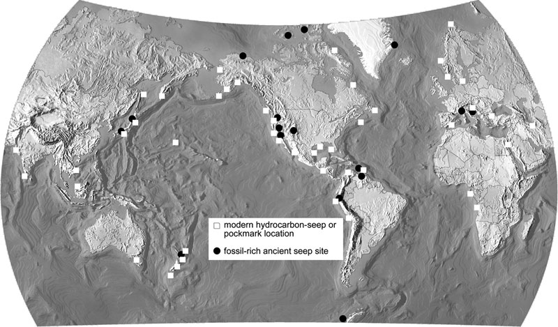
Using remotely operated submersibles in the 1980s and 1990s, scientists established that seep sites extend far beyond hydrocarbon provinces. Seeps are located on practically the whole of the continental margins and represent a general feature of the geohydrologic system (Figure 1).17 Seeps are also found the continents and in some cases, submarine seeps are connected hydrologically to terrestrial groundwater systems. Many seeps support chemosynthetic biological communities. The output from seeps includes natural gas, carbon dioxide, nitrogen, hydrogen sulfide, other gases and oil. Perhaps the most spectacular source of seeps is methane hydrates—gas molecules trapped within crystalline lattices formed by frozen water molecules.18,19
Click here for larger view
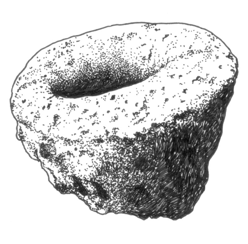
Seeps produce a variety of ocean bottom morphologies such as seep precipitates (carbonates and hydrates), pockmarks, piping and rills, ranging in scale from metres to kilometres. From a sedimentary point of view, some of the most significant seep signatures are carbonate bodies such as irregular mounds, dykes and flat hardground-type surfaces. Many of these features are aligned along fault lines. Sometimes, small-scale parallel, ring and columnar structures, resembling speleothems, are present inside these carbonate bodies.17 Cylindrical to conical structures were identified recently at some seep locations on the ocean bottom (Figure 2). The structure of many paleoseep carbonate bodies is practically identical with modern ones, potentially permitting paleoclimate, hydrological, chemical and biological reconstructions. Paleoseeps seem to have a definite life span, being buried by newer sediments after ‘death’.
As we consider alternative mechanisms for karst-like features, seep morphologies such as pockmarks, piping and rills and seep precipitates are most relevant. Another significant seep feature is the endogenous cave—a cave generated by corrosive fluids ascending through the sedimentary deposits rather than by water percolating from the surface.
Pockmarks are crater-like depressions ranging from less than 1 m to 700 m across, and from 1 m to 30 m in depth.19,20 Their density may be as high as 240 per km2 .21 Such densities of dolines are also present in modern karst areas (Table 1). My investigations in the Padis Plateau area (Romania),22 based on extrapolating measurements from areas smaller than one square kilometre, have revealed densities up to 280 per km2 .
At such a density, subsequent evolution of the ocean-bottom could easily shape the pocked surface into what would appear to be an incipient cockpit, mogote or tower karst.23 Once seep activity ceased, such features would be buried and preserved. If at some later stage they were uplifted and emerged, karstification processes would certainly exploit such ‘inherited’ conditioning and true tower karst would form very quickly. Sometimes such features have survived on steep subterranean slopes without being buried. For example, grooves and pitting have been identified at depths ranging from 1,000 to 3,000 m off the Iberian Peninsula.24 This is far too deep to be explained by eustatic sea level fluctuations during Quaternary.
There is a secondary feature associated with tower karst that has not been satisfactorily explained by normal karstification processes. This is the case-hardening of residual hills and limestone surfaces.25 However, it is easily explained by seep activity. Case-hardening is an induration of highly porous, weak limestone on the slopes of tower karst. It is currently interpreted as a secondary feature, although 230Th/234U dating has failed to yield interpretable ages.25 Explaining case-hardening as a seep-generated carbonate deposit on the slopes of pockmarks (syngenetic in other words) is logical and elegant. Obviously, radiometric dating on such features would be of very little use, if possible at all.

Click here for larger view.
Finally, it is worth mentioning that standard karst interpretations try to relate ‘buried karsts’ to plate tectonics, since most large carbonate deposits were laid down on passive continental margins.26 Yet, by interpreting ‘buried karsts’ as seep-induced pseudokarst, keeping in mind the distribution of ocean bottom seeps presented above, we find that, once again, logic and common sense make the choice of a genetic mechanism an easy task. This syngenetic, seep scenario dramatically reduces the time-scale for the karstification processes, making it easier to incorporate the entire issue within the one-year Genesis Flood. Let it be emphasized once more that all paleokarsts are interpreted from their surficial appearance only, without establishing whether there is any connection to subterranean paleodrains.
Most signature-relevant seeps are hydrocarbon-generated. Thus, one may assume that seeps could only occur since the accumulation of what Walker calls ‘Biotic’ rocks.27 This raises an interesting question: since fluid seeps appear to be confined to the continental margins, where were the continental margins during the Flood? Should we associate Flood seep signatures with continental margins? In the same line of reasoning, we may presume that during the Genesis Flood, seep signatures were rapidly and repeatedly buried by the enormous amounts of sediments associated with the cataclysm. When present in carbonate formations, it is easy to understand why seep signatures are usually associated with what is called intrastratal karst.1 In reality, however, these signatures are simply pseudokarst.
We would expect that during the final stages of the Flood, paroxystic methane and other decomposition gases would seep through the sediments deposited earlier in the Flood. Such seepage would disturb the sedimentary structures, making the efforts of stratigraphers today pretty much guesswork. The formation of gas hydrates after the Flood would not have been possible until ocean temperatures dropped significantly. However, given the immense amount of organic material buried in Flood sediments, non-gas-hydrate seeps would have been intensely active. Once ocean temperatures dropped (possibly 500 years after the Flood, around the glacial maximum as Oard suggested28) methane hydrates could have formed and stored part of the methane. This would have diminished the seep intensity.
Since the Flood, much less organic material has accumulated in sediments. Therefore, it is reasonable to assume that, after a maximum seep intensity sometime after the Flood, a steady decrease in seep activity has occurred. The activity we see today is just a fraction of the intense seep activity during the Ice Age. Indeed, the methane released into the atmosphere at that time may have triggered a global warming and initiated deglaciation.
A Biblical framework
If we are to understand karstification from a Biblical perspective, we need to start with the Biblical timeline; Creation Week, the pre-Flood era, the year-long Flood, and the 4,300-year post-Flood era.27
The initiation of the Flood29 probably involved major lithological changes to the pre-Flood carbonate rocks. Hot brines and associated hydrothermal solutions welling up across the entire lithosphere would have transformed carbonates into a highly plastic rock prone to ultra-rapid pseudokarstification—mainly of the mechanical type. The ‘karst’ features would have been generated by mechanical displacement of rock by fluid and gas flow and slumping. The west to east ‘migration’ of ‘paleokarsts’ I previously described1 could be explained by a progressive upwelling around the globe. It probably began in the Western Hemisphere and gradually made its way to the Eastern Hemisphere. The pseudokarst features followed closely behind. As Flood sediments began to accumulate, increasing seep activity produced seep signatures as part of the sedimentary record, signatures that underwent a series of diagenetic and morphologic changes after burial.
It is likely that the rapidly accumulating Flood sediments periodically emerged. The resultant degassing and dewatering of waterlogged sediments, along with the associated chemical changes, would have developed a wide range of negative relief in a matter of days. Such features would mimic karst landforms, especially when pseudokarst features emerged. Once buried, the features, preserved on carbonate sediments, would have been chemically enlarged and reshaped by corrosive fluids originating within the earth (rather than infiltrated from the surface), especially those liberated by diagenesis. This has been called endogenous karstification,30 and is particularly visible in the Rodnei Mountains, Romania.13,31
One must appreciate that this environment was a highly dynamic one, with the chemical elements in continuous circulation, absorbing some minerals, depositing others, and transforming the rocks in the process. Metamorphic processes are similar, and quartz, for example, can migrate for long distances in the metamorphic zone through the rocks. In such an environment, any void or discontinuity could play a significant role in mobilising or fixing the various elements.
Separation of non-carbonate components during this process was probably continuous and widespread, and these accumulated especially in voids, producing deposits such as red clays, shales, shale partings and bauxites. Some of these deposits may have emerged briefly and been affected by subaerial processes. All would have been altered after burial by diagenesis. Fossils or decaying dead creatures would sometimes end up with these accumulations, their remains bearing clear evidence of water transport, as in the case of the dinosaur bones inside a bauxite lens in Padurea Craiului in Romania.32
Whenever the newly deposited sediments emerged they would have produced isotopic, diagenetic, and even hydrodynamic changes in the sediments below, thus superimposing a new set of patterns in the still hardening rocks. Again, the behaviour of carbonates was probably highly distinctive. When the mega-processes accompanying the Flood ceased, further diagenesis would have affected the buried relief.
During the Recessive stage of the Flood,27 the general pattern of the modern hydrographic network was rapidly eroded onto the unconsolidated waterlogged rocks. Water would remain trapped in the sediments until sufficient hydraulic head developed to promote flow. Consequently, only after the first valleys were shaped into the landsurface—many as deep gorges and canyons—would water be released from the sediment, leaving voids of various sizes. The longer this drainage was delayed, the harder the rocks and consequently the more likely that voids would survive, even if they were large. This dynamic adaptation of the underground waters and the resulting voids to surface flow created the pattern for future karst drainage, cave systems and individual caves. In my view, the standard models for karst development, as presented in the classical treatises, only apply after the post-Flood hydrosphere and atmosphere reached equilibrium.
I believe this Flood/post-Flood model explains why large cave systems exist side-by-side with unrelated, synchronous, narrow ones. One typical case is the Somesul Cald area in the Apuseni Mountains, where a small limestone area (about 4 km2) hosts a huge cave system—called Valea Firii—over 27 km long, with 12 rooms more than 100 m long, the longest reaching 600 m.33 Within the same area, there is a series of long, yet very narrow cave systems and individual caves. It is clear that the large rooms were formed during the Recessive stage27 of the Flood, while the small system is post-Flood.
After the Flood, the development of the continental ice sheets during the early Quaternary would have added to the lithostatic pressure, compacting and sometimes obliterating the existing subterranean karst and buried pseudokarst. Subsequently, as the ice sheets melted, vast quantities of freshwater would have penetrated the deeper structures, further shaping the remaining pseudokarst and cryptokarst features. Water infiltration would have been assisted by a reduction of lithostatic pressure as the ice caps vanished. This effect would have been pronounced under and around the proposed Lake Agassiz in Norh America,34,35 an area in which important paleokarst features are described.

Click here for larger view.
Uniformitarians base their explanation for the large karst rooms on a vadose river passage junction and repeated rockfalls that are subsequently removed by solution.4 Yet, on closer scrutiny, such an explanation has little to do with reality. Large rooms do not occur at every junction inside the same cave. Actually, most of the very large rooms I have visited are not at important junctions. Many are just dramatically enlarged passages. For example, the famous Salle de la Verna in the Pierre-Saint-Martin System—at 45,310 m3 the largest subterranean room in Europe36,37—has nothing to do with passage junctions (Figure 3). Inside the Romanian cave system mentioned above, many huge piles of broken rock sit on the cave floor without any trace of vadose activity.38 Many experienced karstologists tacitly agree that the standard explanation for such large subterranean voids is far from reasonable.
Dewatering and degassing of unconsolidated sediments in the Recessive stage is a simple and logical explanation for cave formation. Once the general features of the surface hydrographic networks were established (controlled by gravity and water/sediment friction), the water contained in the sediments could flow by gravity towards the surface drains. Initially the water moving through the sediments may not have generated voids at the distal end of each subterranean drain if the sediments were very soft. Even so, the flow probably left scars in the sediment, which ended up as unconformities—one of the most favoured paths for karstification. These proto-drains inside the unconsolidated sediments would have continued to grow larger as the floodwater continued to recede and the baselevel (the water level at the cave outlet) continued to fall. Thus, the large rooms, or reservoirs, formed underwater and the buoyancy of the water filling the rooms would have helped to support them. Provided the rooms remained intact, once baselevel fell below the cave entrance, the voids would have emptied of water and become large subterranean rooms or even gorges.
Significantly, most large cave systems have a major vertical development associated with the lowering of baselevel. The largest rooms always occur nearest to the outlet. The Salle de la Verna is the last and lowest room in the famous Pierre-Saint-Martin system, connected via a man-made tunnel to the surface, at the level of the valley of Kakouetta. Vertical sections of the valley show that the flows and rates of karstification are much less now than in the past. Clearly, the largest rooms should be associated with those past conditions.
However, uniformitarians try to explain the largest room as the product of the present, but inadequate karstification cycle. The Flood mechanism I present here makes better sense, suggesting that Kakouetta Valley was cut rapidly, mostly as a narrow gorge. Incredibly, in 1991 heavy rainfall, restricted to the upper circular basin of the valley and lasting less than 2 hours, generated a 15-m high flood that cleaned the gorge of sediments. The beautiful lake at the exit of the gorge was completely filled and vanished. Two years later when I visited the gorge, the effects of the flood were perfectly visible. The large blocks of travertine that had accumulated at the cave outlets had been broken and carried hundreds to thousands of metres downstream by the flood. I couldn’t help thinking that, once buried by sediment, these blocks would mislead future karstologists about where they came from and how they got there.
Not all reservoirs were dewatered. Deep under baselevel many pocket-and conduit-shaped voids survived and remained waterlogged. As diagenesis proceeded, these voids collected the insolubles expelled by lithifying limestones. Once diagenesis was complete these filled cavities lost their water, mostly to clay formation. When opened up, either by karstification or by humans, they reveal pocket and conduit shapes filled with argillites, red clays and even bauxite. The majority of paleokarsts described in the literature are pockets and small conduits filled with argillites and red clay, and are found in the walls of man-made excavations in limestones. Their mineralogy differs little, if at all, from soils on limestones. This is not surprising since they form more or less in the same way, through the separation of insolubles from the limestone and the selective accumulation of insolubles in the rock. There is little chance that any trace of biotic activity (the most reliable evidence for pedogenesis) could survive diagenesis. All this makes me sceptical of claims about paleosoils on, or inside, limestones because such claims are generally assessed on mineralogy only. The same applies to paleokarst fills. Again, common sense requires that, before such claims are made, the geology should be properly analysed for reliable karst indicators, in particular a minimal reconstruction of karst drains.
The Iglesiente paleokarstic fills in Sardinia, Italy
The contrast between the evolutionary and biblical scenarios is best illustrated by field examples. The first example demonstrates what the evolutionary paradigm can make of field data, regardless of obvious problems with the million-year time frame. Although the geological setting is complex with superimposed and recurrent sedimentary, igneous and geomorphic episodes, it is highly representative.
Located in the southwestern part of Sardinia, the Iglesiente lead, zinc, barite and fluorite mining area is built of rocks ranging from Cambrian to Quaternary. The paleokarst features are located in the Gonessa Formation (dolomites and fossil-rich limestones about 700 m thick) of the Middle-Upper Cambrian overlain by Upper Cambrian nodular limestones and slates.39 The underlying Nebida Formation (Lower-Middle Cambrian) is rich in fossils (stromatolites, echinids, brachiopods, trilobites, oncolites, stenotecoids and algae). The top of the Gonessa Formation appears to have been karsted in a period of emergence during the Caledonian orogeny.39 During the Hercynian orogeny granites were emplaced in the adjacent area. Volcanic activity was present during the Late Oligocene and the Miocene.

Click here for larger view.
The paleokarst features range from karren, pinnacles, pockets and dolines filled with terra rossa, to sediment-filled cracks and larger voids considered caves by the authors.39
The Santa Barbara Mine has cut through what is interpreted as a doline carved in the Gonessa Formation‘s fossiliferous limestone (Figure 4). The ‘doline’ is filled with Triassic transgressive sandstones which also appear to be carved by a perfectly overlapping ‘doline’ of unknown age, filled with terra rossa.39 The top of the Triassic sandstones appears to be weathered and covered by a thin layer of sparry calcite, carved by karren and pinnacles. Inside the terra rossa fill, sparry calcite is also present as conical structures resembling speleothems. According to the authors, this setting is recurrent in the area (Figure 5).
The authors claim that the paleokarst was generated during the Lower Ordovician, survived unfilled (or filled and then mysteriously unfilled) for 200 Ma until the Triassic, was filled during that period, karsted again and filled again with terra rossa of unidentified age. The same explanation is given for a number of cave-like cavities that are now completely filled with sediment. About these caves the authors conclude:
‘while these caves developed mostly during the Paleozoic and Mesozoic … the sediments have been deposited after the Cenozoic volcanic activities … ’

Click here for larger view.
This uniformitarian explanation has many problems.
If the Triassic fill of the ‘doline’ in Figure 4 is transgressive, then why isn’t the layering more-or-less parallel? The underlying limestones are horizontal and the claimed unconformity is also horizontal. It is not plausible to invoke suffosion (a category of piping through the evacuation of fines by a combination of solution and downwashing40) as there is no trace of subjacent voids into which fines could be washed. Such a stratigraphic pattern is easily explained if the sandstones were initially deposited horizontally over a seep area and after degassing, the still-plastic sediments slumped into the newly created void, to be rapidly cemented by the seep precipitates. The same seep precipitates generated the irregular sparry calcite layer and, it appears, the conical speleothem-like formation in the terra rossa fill.
The carbonate sequence of the Gonessa Formation covers the middle and upper part of the Lower Cambrian—supposedly a period of some 12 Ma. Yet, as shown by the stratigraphic column in Figure 5, the alleged dolines formed throughout this entire period. This implies repeated emergence and karsting but there are no unconformities inside the limestones or dolomites. A syngenetic origin for the ‘dolines’ is more reasonable and the most likely mechanism is paleoseep activity as presented above. This rules out a long duration of genesis by karst processes.
If the intense, recurrent and chemically variable magmatism occurred after the caves had formed, then why is there no sign of hydrothermal fill? All the cave fills described by the authors are of the classical karst type. There are no hydrothermal fills described at all. Yet, all the economically significant mineralizations are located inside the limestones. Furthermore, there is no mention of any secondary migration of any cations (Pb, Zn, Ba) towards the paleokarstic voids. This is most unusual and ungeological. It all makes sense, however, if the ‘paleokarst’ is younger than the igneous rocks, so young that leaching and migration of the cations towards the voids has not occurred.
A creationist interpretation of Iglesiente
The Gonessa Formation was deposited during the Flood and subject to recurrent paleoseep activity originating from the underlying, organic rich Nebida Formation. This produced pockmarks, sometimes overlapping, and incorporated various seep precipitates. Subsequent diagenesis preserved the pockmarks as features, which are strikingly similar to paleodolines.
Towards the end of the Ice Age, a classical karst began developing on the island and as the climate became warmer and more humid, autochthonous and allochthonous sediments began filling the karstic voids. The rapidly rising sea level restricted the formation of large cave systems to the higher elevations. However, the small cavities at lower levels might have been subjected to marine invasion and erosion.
The Guadelupe Mountains karst
The Guadelupe Mountains karst illustrates that caves can be generated by agencies originating under, rather than above, the ground. Such caves are called endogenous30 or hypogene.40 Many famous caves are located in the Guadelupe Mountains (New Mexico, Texas) such as the Carlsbad Caverns, its neighbour Lechuguilla Cave (probably the most beautiful cave in the world), and 30 other major caves.40 This karst system is outstanding for its large rooms and passages, its blind pits, and its abundant, splendidly crystallized, evaporite speleothems.41 Apparently there is no significant connection with the surface except for the entrances, which were opened by erosion.
Karstologists are split about how the Guadelupe karst formed, because the caves contain huge calcite and evaporite speleothems. Some support per ascensum genesis by H2S that originated from the underlying Permian oil and gas fields. They interpret the calcite speleothems as secondary features.41 Others, such as Ford and Williams,42 invoke a classical karstification process of which the calcite speleothems are by-products. Nevertheless, these authors propose a polygenetic origin, proposing that there was some H2S involvement, especially in a late phase, when H2S-rich backwater ponding generated the enormous evaporite speleothems. Regardless of the scenario, all authors agree that the Guadelupe karst is relatively old—probably pre-Quaternary.
Similar karst has been identified in Italy (Grotte di Frasassi)42 and the Republic of Georgia (Akhali Atoni Cave).43 Interestingly, some consider the latter to be of hydrothermal origin.44
A creationist interpretation of the Guadelupe Mountains karst
On rare occasions, continental seep signatures may develop way beyond tar ponds, like the famous Rancho La Brea, or mud volcanoes, like those at Pâclele Mari in Romania. I believe the supporters of the per ascensum, hypogene formation of this karst are correct to claim that the karst was carved mainly by sulfuric acid. They propose that H2S originated from the subjacent Permian oil and gas fields, rose to the water table, and oxidized to H2SO4. Naturally, corrosion by H2SO4 is much faster than classical CO2-driven corrosion. The general chemical reactions are:41
| H2S + 2O2 → H2SO4 | (1) |
| CaCO3 + H2SO4 + H2O → CaSO4 •H2 O (gypsum) + H+ + HCO3– | (2) |
It has been calculated that the amount of H2S required to generate Carlsbad Cavern’s Big Room (in excess of 106 m3) is less than 10% of one year’s commercial production from the nearby gas fields in New Mexico.41 No one has calculated the actual increase in the rate of limestone dissolution by H2SO4, but it is generally believed to be much higher than for CO2. Furthermore, Bakalowicz45 pointed out that the aggressiveness of sulfuric acid solutions can be further increased by CO2 generated in the limestone as follows:
| CaCO3 + 2H+ → Ca2+ + CO2 + H2O | (3) |
Under such circumstances, given the vast amounts of gas seep in the period immediately after the Flood, I believe the Guadelupe karst could have been excavated in several centuries. Development would have been especially rapid around glacial maximum, when the extra pressure of the North American ice sheet increased seep activity, and while water flow in the surface drainage system was significantly reduced due to the periglacial surface conditions. Increased seep activity and reduced water infiltration (as generally accepted among karstologists) meant that sulfuric acid karstification prevailed.
This situation changed once the ice sheet started to retreat, relieving the lithostatic pressure and reducing seep activity. Increased volumes of surface waters in the river systems and lakes (like Missoula, Hopi, Canyonlands, and Vernal46) would favour infiltration. Thus, the balance reversed and classical karsting processes took over briefly until the climate of the area became arid. However, the only significant by-products of this infiltration, which is still active today, are calcite speleothems, some of which are huge. In my experience there is little, if any, connection between the size and age of speleothems and I hope to demonstrate this in future papers.
Conclusions
Currently, geologists tend to interpret as ‘paleokarst’ any paleorelief in soluble rocks of the Precambrian, Paleozoic and Mesozoic. Such interpretations are hasty and are based on very few, mostly morphologic arguments. Paleokarst should not be assumed unless careful investigation has revealed true karstic features. In particular, unless clear surface-to-subsurface genetic connections are identified revealing the basic function of karst systems (the transit of water through lithostructures), the features are most likely pseudokarst, not paleokarst.
All ‘paleokarst’ interpretations are to be treated with caution because true paleokarst is unlikely to have been preserved for the length of time implied. A paleokarst would represent a marked anisotropy inside a limestone sequence and provide preferential access for corrosive, karsting water. Consequently, the older the paleokarst, the less chance it has of surviving.
Paleokarst would not survive, irrespective of its depth of burial. If it were buried deeply (greater than 1,800 m), then lithostatic pressure and diagenesis would destroy it. If it were not buried deeply, then corrosive water would reach it and alter it.
The recently discovered geomorphic features associated with fluid and gas seeps provide a coherent explanation for alleged ‘paleokarsts’. Within a Biblical geological framework, recurrent seep signatures together with occasional emergence during the Flood elegantly explain the various pseudokarst horizons in the geological record.
There is little, if any, chance of using ‘paleokarst’ to locate the pre-Flood/Flood boundary, since old ‘paleokarst’ would not have survived. However, paleokarst can help determine the Flood/post-Flood boundary. Since there are non-karstic (pseudokarstic) explanations for all alleged ‘paleokarsts’ older than Quaternary, the post-Flood boundary must occur after the Tertiary. Future investigations into speleogenesis and speleothems may provide more arguments and better estimates.
Editors’ note
Original manuscript was received on 10 April 2001. It is worth noting that the papers dealing with alleged paleokarsts by Silvestru and Woodmorappe in this issue of Journal of Creation were prepared independently of each other. Any similarities between the concepts expressed are due to creationist thinking converging upon a solution to an alleged problem.
References
- Silvestru, E., Paleokarst—riddle inside confusion, Journal of Creation 14(3):100–108, 2000. Return to Text.
- Cryptokarstification is active karstification under a thick sedimentary cover. See Choppy, J., Dictionaire de spéléologie physique et karstologie, Speleoclub de Paris, 1985. Return to Text.
- Silvestru, E., Stratigrafia si sedimentologia depozitelor clastice din exo si endocarstul zonei Padis-Cetatile Ponorului, Ph.D. Thesis, Universitatea ‘Babes-Bolyai’, Cluj, 1997. Return to Text.
- Ford, D.C. and Williams, P.W., Karst Geomorphology and Hydrology, Chapman and Hall, London, 1992. Return to Text.
- Cociuba, I. and Silvestru, E., Hypothesis on a genetical relation between the actual karst and the bauxite-bearing paleokarst at the Jurassic/Creatceous boundary in the Piatra Craiului Mountains (Romania), Travaux de l’Institut de Spéologie ‘Emil Racovitza’, (Bucharest), XXVIII:87–90, Bucuresti, 1989. Return to Text.
- Davidescu, F.D., Tenu, A. and Slavescu, A., Environmental isotopes in karst hydrology: a layout of problems with exemplifications in Romania, Theor. Appl. Karst. (Bucharest), 4:77–86, 1991. Return to Text.
- Bleahu, M.D., Morfologia carstica, Editura Stiintifica, Bucuresti, p. 472, 1976. Return to Text.
- Tenu, A. and Davidescu, F., Environmental isotopic studies in karstic calcareous areas of Romania, Theor. Appl. Karst. (Bucharest), 8:9–24, 1995. Return to Text.
- The vadose zone, or zone of aeration, lies between the water table and the land surface. Return to Text.
- Bleahu, Ref. 7, p.474. Return to Text.
- Jordan, R.H., An interpretation of Floridan karst, J. Geol. 58(4):291–268, 1950. Return to Text.
- Henshaw, B.B., Back, W. and Rubin, M., Carbonate equilibria and radiocarbon distribution related to groundwater flow in the Floridan limestone aquifer, U.S.A, Hydr. des roches fissur, Actes Geol. Dubrovnik, AIHS-UNESCO, II: 601–614, 1965. Return to Text.
- Silvestru, E., Aspects of karstification in the crystalline limestones on the southern slope of Rodnei Mountains, Theor. Appl. Karst. (Bucharest), 2:87–95, 1985. Return to Text.
- Ford and Williams, Ref. 4, p. 510. Return to Text.
- Bosák, P., Paleokarst of the Bohemian Massif in the Czech Republic: short review, Acta Carsologica (Ljubliana) XXIV:109–121, 1995. Return to Text.
- Silvestru, E., Bubbles of surprise, Journal of Creation 15(2):89–93, 2001. Return to Text.
- Moore, C. J., Fluid seeps at continental margins; a report of a workshop defining critical research issues affecting geology, biology, the oceans and the atmosphere, 1999, <www.soest.hawaii.edu/margins/seeps_workshop.html>, 23 August 1999. Return to Text.
- Paull, C.K., Ussler III, W. and Borowski, W.S., Methane-rich plumes on the Carolina continental rise: association with gas hydrates, Geology 23(1):89–92, 1995. Return to Text.
- Monastersky, R., The mother lode of natural gas—methane hydrates stir tales of hope and hazard, Science Service Inc., pp. 1–3, 1996. Return to Text.
- Natural History of Nova Scotia, v 1, T.3.5: Offshore bottom characteristics, pp. 71–79. The reference, in pdf format, is at: <museum.gov.ns.ca/mnh/nature/nhns/index.htm>, 30 August 2001. Return to Text.
- Hovland, M. and Judd, A.G., Seabed Pockmarks and Seepages—Impact on Geology, Biology and the Marine Environment, Graham and Trottman, London, pp. 58–118, 1988. Return to Text.
- Silvestru, E., Dolines in the Padis Plateau [Bihor Mountains, Romania]—one peculiar case, many questions, Theor. Appl. Karstology, (Bucharest), 10:127–132, 1997. Return to Text.
- Ford and Williams, Ref. 4, pp. 440–444. Return to Text.
- Maire, R., Apropos des karsts sous-marins, Karstologia 7:55, 1986. Return to Text.
- Ford and Williams, Ref. 4, pp. 444–445. Return to Text.
- Ford and Williams, Ref. 4, p. 510. Return to Text.
- Walker, T., A biblical geologic model, Proc. 3rd Internat. Conf. Creat., Creation Science Fellowship Inc., Pittsburgh, pp. 581–592, 1994. Return to Text.
- Oard, M., An Ice Age Caused by the Genesis Flood, ICR, San Diego, 1990. Return to Text.
- Austin, S.A., Baumgardner, J.R., Humphreys, R.D., Snelling, A.A., Vardiman, L. and Wise, K.P., Catastrophic plate tectonics: a global Flood model of Earth history, Proc. 3rd Internat. Conf. Creat., Creation Science Fellowship, Pittsburgh, pp. 609–622, 1994. Return to Text.
- Silvestru, E., Propositions pour une classification litho-génétique des formes karstiques et apparentées, Karstologia 15:55–57, 1990. Return to Text.
- Mârza, I. and Silvestru, E., First mention of the hydrothermal karst phenomenon associated to Neogene metasomatic sulphide ore deposits from Rodna Veche, Studia Universitatis ‘Babes-Bolyai’, Geologica-Geographica, Cluj-Napoca, XXXIII, 77–81, 1988. Return to Text.
- Oard, M., What can 10,000 dinosaur bones in a bauxite lens tell us? Journal of Creation 13(1):8–9, 1999. Return to Text.
- Silvestru, E., Tamas, T., and Fratila, G.H., Preliminary data on the hydrogeology of karst terrains around the springs of Somesul Cald River (Bihor-Vladeasa Mountains, Romania), Theor. Appl. Karstology, (Bucharest), 8:81–89, 1995. Return to Text.
- Broecker, S.W. and Denton, H.G., What drives glacial cycles?Scientific American 262(1):49–56, 1990. Return to Text.
- Broecker S.W., Unpleasant surprise in the greenhouse? Nature 328:123–126, 1987. Return to Text.
- Chabert, C., Les grands phenomènes karstiques français pae les chifres, Karstologia 11–12:1–6, 1988. Return to Text.
- Maire, R. and Quinif, Y., Chronostratigraphie et évolution’sédimentaire en milieu alpin dans la galerie Aranzadi (Gouffre de la Pierre Saint Martin, Pyrenées, France), Ann. Soc. Géol. Belg, 111:61–77, 1988. Return to Text.
- Mârza, I. and Seliscan, D., Phénomènes d’éboulements massifs dans la Grotte de Valea Firii (Basin du Somesul Cald) dus à la néotectonique épisodiquement réactivée, Studia Universitatis ‘Babes-Bolyai’, Geologica-Geographica, Cluj-Napoca, XXXII/2:81–86, 1987. Return to Text.
- Bini, A., Cremaschi, M., Forti, P. and Perna, G., Paleokarstic fills in Iglesiente (Sardinia, Italy): sedimentary processes and age, Ann. Soc. Géol. Belg, 111:149–161, 1988. Return to Text.
- Ford and Williams, Ref. 4, p. 287. Return to Text.
- Hill, C.A., Geology of Carlsbad Caverns and other caves of the Guadelupe Mountains, New Mexico and Texas, N. M. Bureau Mines and Miner. Resources Bull. 117, 1987. Return to Text.
- Ford and Williams, Ref. 4, p. 289. Return to Text.
- Titilozov, Z.K., Akhali Atoni Cave System, Metsniereba, Tbilisi, U.S.S.R, 1983. Return to Text.
- Dubliansky, V.N., Hydrothermal karst in the alpine folded belt of southern parts of the U.S.S.R., Kras i Speleologia 3(12):18–36, 1980. Return to Text.
- Bakalowicz, M., La karstification: processus, modèles et examples, Proc. 9th Intren. Congr. Speleol., Barcelona, III:59–63, 1986. Return to Text.
- Austin, S.A. (Ed.), Grand Canyon—Monument to Catastrophe, ICR, Santee, CA, 284 p., 1994. Return to Text.
Readers’ comments
Comments are automatically closed 14 days after publication.