

How valleys and canyons formed during Noah’s Flood

Continental valleys and canyons come in all sizes and shapes. Some are V-shaped valleys, and others U-shaped canyons. Some are shallow and others have tall vertical walls, like the Grand Canyon. We rarely observe valley and canyon formation taking place today and then only in association with a flooding event. Therefore, uniformitarian1 theories about valley and canyon formation are not built on observational science but instead upon their assumptions about the past.
The great debate over the origin of valleys
The origin of valleys was strongly debated around the year 1800. ‘Enlightenment’ scientists claimed it would take millions of years to form most valleys by present processes. The existence of valleys, such as Zion Canyon in Utah (figure 1), was one of the more forceful arguments presented to support an old age for the earth and to justify the uniformitarian assumption that present processes carved all the valleys.2 Catastrophists, on the other hand, held that valleys were carved by catastrophic flows of water. A few thought the catastrophe responsible was the Genesis Flood, but most scientists insisted that valleys were carved by some other phenomenon, like a huge tsunami.3

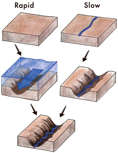
The debate was basic: which came first, the valley or the river?4 Figure 2 illustrates the two concepts. Uniformitarian scientists claimed streams and rivers slowly eroded the valleys, and that cataclysmic events, like the global Flood, had nothing to do with their formation. They simply declared that streams or rivers came first and eroded the valleys slowly over millions of years.5 They won the day, and today the vast majority of geologists accept this explanation.
It was a change in thinking in the late 1700s and early 1800s that allowed these scientists to reject the Genesis Flood as an agent for valley formation. This was not a reasoned argument based on objective fieldwork. It was an arbitrary, subjective decision; a philosophical rejection of the history recorded in the Bible.6 There was no clear scientific evidence supporting their claims of slow-and-gradual valley formation.
Rapid excavation of valleys and canyons
The eruption of Mount St. Helens has taught us much about catastrophic processes and volcanic mudflows, called lahars.7 Scientists observed the rapid, catastrophic formation of canyons with vertical or near-vertical walls in both unconsolidated sediment and solid rock.8 The old valley of the North Fork of the Toutle River was filled with debris up to 180 metres (600 feet) deep. Some of this debris was layered, some layers being quite thin. This is similar to what we find in other sedimentary rock assumed to have been laid down over long ages. On 19 March 1982, a small eruption of Mount St Helens melted snow within the crater and formed a large mudflow. The mudflow eroded back toward the mountains and downward, forming a 35 m (115 ft) deep canyon with vertical walls. It is approximately one-fortieth the size of the Grand Canyon—and was carved in a single day! Moreover, the canyon has branching tributaries feeding into the main canyon. A small stream now flows down the canyon. If a geologist knew nothing of this canyon’s formation, he would most likely conclude the canyon was slowly eroded over many thousands of years by the small stream. But he would be misled by his uniformitarian assumptions. The canyon came first!

Another vertical-walled canyon that was carved rapidly by water in modern times is Burlingame Canyon, in southeast Washington. It is about 30 m (100 ft) deep (figure 3), and was formed in six days in March 1926 by the diversion of water from an irrigation ditch down a side channel.9
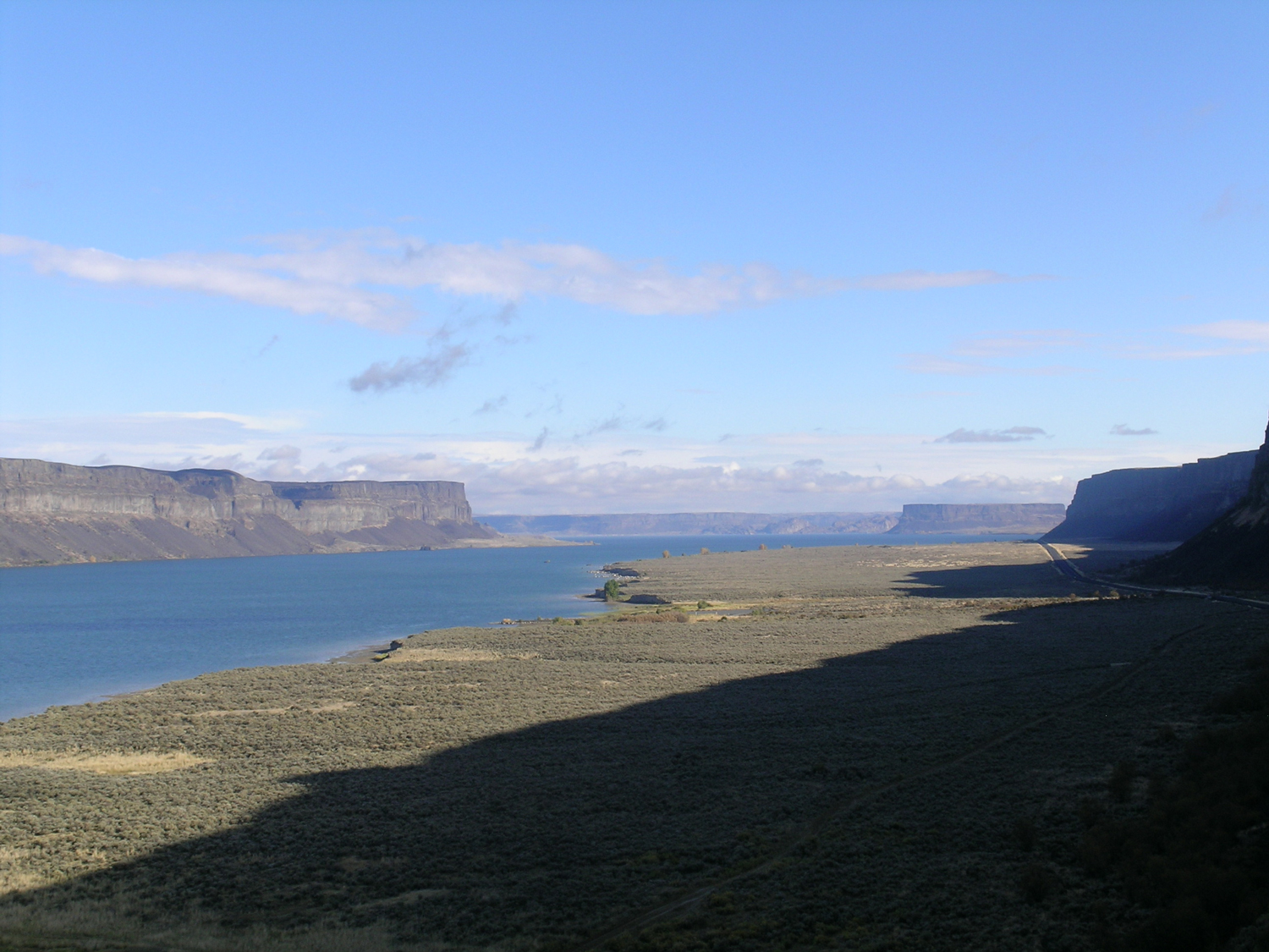
During the Lake Missoula flood toward the end of the Ice Age, dozens of vertical-walled valleys were cut in hard basalt and were formed in days.7,10 This includes Grand Coulee with vertical walls up to 275 m (900 ft) high (figure 4).
Geomorphologists, who study the shape of the landscape, know that vertical-walled canyons soon develop a more V-shaped profile with time, because as the valley walls erode, their slope decreases.11,12 This is because, as Pazzaglia wrote: “Erosion rates are most rapid where slopes are steep … .”13
Twidale noted:
“… valleys incised in a new surface tend to be relatively deep and steep-sided … . It is safe to predict, however, that with the passage of time, the valleys will be widened, and that eventually they will develop a narrow V-shaped cross section … .”14
Rapid late-Flood incision of valleys and canyons
Flood runoff easily explains the formation of valleys and canyons. Early in the Recessive Stage of the Genesis Flood as the floodwater was flowing off the continents, wide, sheet-like currents of water deeply eroded the surface of the land.15 Large areas of sedimentary rock were scoured forming large, flat surfaces,16 called planation surfaces. The debris eroded from the continents at this time was deposited as a continuous wide sheet of sediment along the continental margins.17
As the floodwater continued to flow off the continents, more mountains and plateaus became increasingly exposed, forcing the floodwater to go around the obstructions in channels. These channelized currents rapidly carved wide valleys and canyons. Over time the water currents reduced and narrowed. Eventually, the floodwater had completely drained into our present-day oceans. Today our rivers and streams take the path of least resistance and flow in these channels (eg Slot Canyon).

It is important for geologists to recognize the sequence of events that created the features we see today. Sheet flow formed the broad erosional features first, and channelized flow formed the narrower features superimposed upon (etched into, as it were) the sheet-flow landscapes. Evidence of this two-part erosional process can be observed all over the world. The Canyon de Chelly, in northeast Arizona, USA (figure 5) demonstrates this pattern. Sheet erosion over a wide area formed a generally flat planation surface. Later, channelized currents rapidly cut the canyon. It happened so quickly that it left behind a tall, narrow inselberg,18 Spider Rock. This pattern of a vertical-walled canyon with valley inselbergs would not exist if it had taken millions of years of erosion to form the canyon.
The amazing valleys and canyons we see all over the world are a silent but powerful monument to the second stage of Noah’s Flood, when the waters flowed from the continents into the ocean basins.
References and notes
- Uniformitarianism is the assumption that the same sorts of slow-and-gradual geological processes that we see happening in the present have more or less always operated that way in the past. It denies the global Flood described in the Bible. Return to text.
- Chorley, R.J., Dunn, A.J., and Beckinsale, R.P., The History of the Study of Landforms or the Development of Geomorphology—Volume One: Geomorphology before Davis, Methuen & Co. Ltd, London, UK, pp. 63–64, 125–139, 1964. Return to text.
- Reed, J.K., Three early arguments for deep time—part I: time needed to erode valleys, J. Creation 25(2):83–91, 2011; creation.com/deep-time-1. Return to text.
- Powell, J.L., Grand Canyon: Solving Earth’s Grandest Puzzle, PI Press, New York, NY, p. 28, 2005. Return to text.
- Schumm, S., and Ethridge, F.G., Origin, evolution and morphology of fluvial valleys; in: Dalrymple, R.W., Boyd, R., and Zaitlin B.A. (Eds.), Incised-Valley Systems: Origins and Sedimentary Sequences, SEPM Special Publication No. 51, Tulsa, OK, p. 11, 1994. Return to text.
- Catchpoole, D. and Walker, T., Charles Lyell’s hidden agenda—to free science “from Moses”, 19 August 2009; creation.com/Lyell. Return to text.
- Morris, J.D. and Austin, S.A., Footprints in the Ash, Master Books, Green Forest, AR, 2003. Return to text.
- Morris and Austin, ref. 7, pp. 71 and 76. Return to text.
- Oard, M.J., The Missoula Flood Controversy and the Genesis Flood, Creation Research Society Books, Chino Valley, AZ, 2004. Return to text.
- Oard, M.J., The Great Missoula Flood: Modern Day Evidence for the Worldwide Flood, Awesome Science Media, Canby, OR, 2014. Return to text.
- Twidale, C.R., Geomorphology with Special Reference to Australia, Thomas Nelson Ltd, Melbourne, Australia, pp. 148–203, 1968. Return to text.
- Bloom, A.L., Geomorphology: A Systematic Analysis of Late Cenozoic Landforms, Prentice-Hall, Englewood Cliffs, NJ, pp. 163–196, 1978. Return to text.
- Pazzaglia, F.J., Landscape evolution models: in: Gillespie, A.R., Porter, S.C., and Atwater B.F. (Eds.), The Quaternary Period in the United States, Elsevier, New York, NY, p. 249, 2004. Return to text.
- Twidale, Ref. 11, pp. 164–165. Return to text.
- Oard, M.J., Massive erosion of continents demonstrates Flood runoff, Creation 35(3):44–47, 2013; creation.com/continental-erosion. Return to text.
- Oard, M., It’s plain to see: Flat land surfaces are strong evidence for the Genesis Flood, Creation 28(2):34–37, 2006; creation.com/plain. Return to text.
- Oard, M.J., Flood by Design: Receding Water Shapes the Earth’s Surface, Master Books, Green Forest, AR, pp. 61–64, 2008. Return to text.
- Inselbergs: Evidence for rapid Flood runoff, Creation 39(1):46–49, 2017. Return to text.


Readers’ comments
Comments are automatically closed 14 days after publication.