

Journal of Creation 35(3):50–63, December 2021
Browse our latest digital issue Subscribe
Candidate site for Noah’s Ark, altar, and tomb
While researching a Babel candidate site near Diyarbakir, Turkey, on 3 October 2019, we found a complex of sites on the mountain Karaca Dag that, upon further examination, seem to match the description of the landing site of Noah’s Ark, along with a tomb, possible altar, and much more. The tomb is a 60-m-square, rough stone mastaba, oriented to the winter solstice sunrise, with two extensions that make it into roughly a 160-m-long boat shape. The site is marked by six or more geoglyphs, situated along an arc 5 km distant on the northwest side of the mountain. The possible remains of the Ark appear to have had a modern school built on them, now collapsed.

We would expect to find the landing site of the Ark near the centre of the oldest post-diluvial distribution of humans and domesticated plants. The site presented in this paper lies upon a mountain between the Tigris and Euphrates Rivers at the centre of the Pre-Pottery Neolithic A (PPNA) Culture.
This mountain, Karaca Dag, is where the genetic ancestor of all domesticated Einkorn wheat was found by the Max Planck Institute.1 The other seven founder crops of the Neolithic Revolution all have this mountain near the centre of their wild range.2 This was so exciting that even the LA Times remarked how unusual it is that all of the early agriculture crops appear to have been domesticated in the same location:
“The researchers reported that the wheat was first cultivated near the Karacadag Mountains in southeastern Turkey, where chickpeas and bitter vetch also originated. Bread wheat—the most valuable single crop in the modern world—grapes and olives were domesticated nearby, as were sheep, pigs, goats and cattle.”3
If this site is what we suspect it to be, then the Ark itself has long ago rotted away, leaving nothing but a long patch of gravel ballast and perhaps some broken pottery. Coordinates: 37°42’45.76”N 39°49’57.68”E
Upon the gravel patch a school for shepherd children was built in 1928, now collapsed.
The adjacent stone tomb appears unscathed. Further away on the slopes of the mountain several geoglyphs mark the site. Two of them appear to contain writing in an unknown script.
In addition to the geoglyphs there is evidence of ancient human habitation, farming, roads, and terraces on both ends of the mountain, 10 km north and south of the tomb and Ark site.
We will also review evidence that the site was desecrated in ancient times, making us less surprised to see recent desecrations.
Criteria
Ark searchers have claimed to find petrified wood4,5 or a frozen, intact wooden structure above the permanent snowline.6 Unless it landed at an elevation above 3,000 m, we expect any wood to have rotted away long ago.
Low value imperishable materials might survive. Considering that the Ark carried a large cargo of relatively low-density food stuff such as hay, it seems likely that it would have required ballast to ride low enough in the water. Any ballast is likely to still be there in the footprint of the vessel. We would expect to find a foreign patch of gravel, sand, or stones.
Food stores in the Ark must have been placed in rodent-resistant vessels. Therefore, we should expect to find fragments of broken vessels.
Noah built an altar nearby. Earth and stone are the only known materials for an altar for animal sacrifice (Exodus 20:24–25). The altar should have survived in some form unless it was destroyed by religious vandalism.
Extrabiblical sources inform us that Noah was buried on top of the mountain near the Ark.7 St Ephraim lived in both Amida (Diyarbakir) and Edessa (Sanliurfa), adjacent to Karaca Dag. He said that Noah’s tomb was near the Ark site.8,9 Hippolytus recorded the tradition that Noah brought the bones of the pre-Flood patriarchs in the Ark and reburied them after the Flood.10
Other probable criteria:
- Region of ‘RRT’ (Urartu, Ararat, Aratta)
- Mashu or Masis (names of Ararat in Sumer and Armenia)
- Villages on the mountain top11
- East-west axis to the site of the Tower of Babel (Genesis 11)
- Nearby tombs of Noah and/or Pre-Flood Patriarchs
Finding the right mountain
We analyzed the traditions of the church fathers, Midrash, Book of Jubilees, and other historical sources for the Ark, with gratitude to Bill Crouse9 who did an excellent job compiling those sources in order to justify Mt Judi as the Ark site. For this comparison we used the following pairings of Ark and Babel sites: Ararat-Babylon, Durupinar-Babylon, Judi-Tel Brak, Karacadag-Çınar. Table 1 compares proposed Ark sites using these criteria. For each of 35 claimed facts, one point was awarded for a strong positive, one half point for a weak positive, and zero points for a negative.
Table 1. Comparison of claimed facts to Ark sites

While patristic sources seem to converge on a mountain which lay in both the Tigris and Euphrates watersheds, we recognize that the early church fathers may have been mistaken.
Since we do not know if the church fathers had the correct site, let’s consider some more objective criteria. As discussed in our Babel paper, the PPNA and the eight Neolithic founder crops have distributions roughly centred on the region around Diyarbakir, which includes Karaca Dag.2
While all nations scattered from Babel, the Bible informs us that ‘Noah began to be a farmer’ shortly after the Flood. Based on this evidence we would expect that farming began near the Ark site one to seven centuries before Babel was founded, depending on one’s preferred chronology. For this reason, the maps of the current wild distributions of the Neolithic founder crops could be indicative of the Ark site. We recognize that changing patterns of rainfall could have altered the ranges of these plants in the time since the Flood.
Manfred Heun was the botanist who followed the DNA of domesticated wheat back to its source on Karaca Dag:
“We believe that the idea is so good—the idea of cultivating wild plants—that we think it might be one tribe of people, and that is fascinating,” said Manfred Heun at the University of Norway’s department of biotechnological sciences, who led the research team. “I cannot prove it, but it is a possibility that one tribe or one family had the idea [emphasis added].”3
The extrabiblical sources Josephus and the Book of Jubilees indicate that the ‘Arkonauts’ spent about a century on top of the mountains of Ararat before coming down to the plain to build Babel. This suggests that the mountain was low enough to allow agriculture and viticulture on its heights.
Josephus tells of one and Jubilees tells of three villages near the Ark site that preceded Babel. If these are accurate, then Babel is only the second or fourth oldest settlement in the world.
A 2004 DNA study of wild and cultivated grapevine genetics by McGovern and Vouillamoz found the region where grapevines were first domesticated. Vouillamoz reports:
“Analysis of morphological similarities between the wild and cultivated grapes from all Eurasia generally support a geographical origin of grape domestication in the Near East. In 2004, I collaborated with Patrick McGovern to focus on the ‘Grape’s Fertile Triangle’ and our results showed that the closest genetic relationship between local wild grapevines and traditional cultivated grape varieties from southern Anatolia, Armenia and Georgia was observed in southern Anatolia. This suggests that the headwaters of the Tigris and Euphrates rivers in the Taurus Mountains is the most likely place where the grapevine was first domesticated! … . This area also includes the Karacadağ region in the northern part of the Fertile Crescent.”12
Christian scholars, for nearly a millennium, have assumed Ararat was the Ark site and Babylon was the Babel site, despite these two sites being separated by 800 km of extremely rugged terrain.
Without delving into the chronology dispute between the LXX and MT camps, we ask a simple question. If you came from an advanced society and landed in a barren new world in a massive ship containing food, tools, containers, furniture, thousands of storage vessels, and a library, and you did not have any roads, exactly how far would you travel on foot to found your new capital city?

Given that the time for the multiple round trips required to carry the cargo to the new site increases at double the increase in distance, would not the answer be “the shortest distance possible”? The Ark was a container ship full of valuable equipment for a nascent civilization with no immediate means to obtain more metals or high-quality tools.
Karaca Dag lies very near the centre of the PPNA sites and the wild ranges of the eight Neolithic founder crops. To this we can add the first viticulture, and the first domestication of dogs and pigs. The evidence that virtually every aspect of farming began on or near Karaca Dag strongly suggests this is the most likely Ark landing site. The fact that the PPNA nations spread out from Karaca Dag also suggests it is near ground zero for Babel.
Figure 1 shows a map of the Natufian Culture, which is the oldest known civilization in Canaan. It matches the Canaanite horn of the PPNA, as shown in our Babel paper. The Natufian distribution looks like a vector directly from the mountain Karaca Dag to the Land of Canaan, suggesting that Karaca Dag was the point of origin.
Figure 2 shows estimated locations of the ‘Mountains of Urartu’ and the ‘Gordean Mountains’ using the data in table 1.

Geology
Karaca Dag is a shield volcano located on the Arabian Plate, believed to have erupted in the Pliocene.13 The lava flows have been dated to 2.7–1.5 Ma by argon dating alone.14 Both Karaca Dag and Mt Judi are shown as being Pliocene deposits, one volcanic and the other sedimentary.15
This Ark site falls into the middle of the creationist debate over the post-Flood Boundary. Using the criteria of Snelling,16 the lead promoter of the K-T boundary, a Pliocene site is post-Flood. If the post-Flood boundary is below the Pliocene, then both Karaca Dag and Mt Judi would be ruled out.
The new ICR Flood Model of Clarey17 defines the post- Flood boundary at the Neogene-Quaternary boundary (N-Q) just above the Pliocene, by which both sites would pass.
Unlike Mt Ararat and Mt Judi, Karaca Dag is surrounded and covered with confirmed remains of the very oldest human civilization on Earth, the PPNA. Those who claim the mountain was formed by post-Flood eruptions have the burden of explaining how the Neolithic farming revolution could have occurred atop an actively erupting volcano, the sheer scale of which would have wiped out any humans living near it.
Farming is normally done in valleys, because deep soil accumulates there. The only instances where farming was found on mountains have been where the bottom lands are already maximized and population requires it. The origin of grain farming on top of a single mountain goes against everything we know about agriculture. Yet the evidence is established. Farming began on the slopes of the mountain known as Karaca Dag. Having seen those rock-covered slopes in person, we can attest that it is the last place anyone should ever try to farm.
If we put off the problem by positing that Babel occurred five to seven centuries after the Flood, we now must explain why paleolithic man, whose remains have been found from Europe to Japan, suddenly converged on Karaca Dag to begin farming, viticulture, and domesticating animals only in one place. Even the Levantine Neanderthal sites are congregated around Karaca Dag.
We see three possible explanations for the data:
- The mountain may be older than the Pliocene.
- Logic requires that one or both of the Flood-boundary positions must be wrong.
- This site may be something much later than the Flood or Babel, and isn’t what we think it to be.
We will simply share what we’ve found and leave the boundary debate to the geologists.
Mount Mashu
The old name of Karaca Dagh is ‘Masia’18 which is based on the older words ‘Masis’ or ‘Mashu’, which means ‘high hill’ in Semitic. The Armenian name for Mount Ararat today is also ‘Masis’, indicating that Karaca Dag may be the original Armenian Masis, prior to their expulsion from their southern homeland.9 The Armenian ‘Masis’ means a double peak. The seventh summit of Karaca Dag also appears to be a twin peak.
The Altai flood legend states that the Ark landed on a mountain with eight peaks.19 Both the Epic of Gilgamesh and “Enmerkar and the Lord of Aratta” require the hero to cross seven mountain ranges or peaks to arrive at the site.

Livingston argued that Gilgamesh claimed to have taken revenge on the God ‘Huwawa’, who sent the Flood, and that Huwawa is a corruption of Jehovah.20 This suggests that Gilgamesh went to the ‘Cedar Mountain’ to kill Jehovah, or symbolically, His priesthood. If a man of the era before Abraham wished to take revenge upon Jehovah, one might expect to find Him at the altar where He was worshipped. The only altar to Jehovah prior to Abraham that we know of was the one built by Noah near the Ark.
Following Dr Livingston,20 we presume the Ark and altar were the destination of the first journey of Gilgamesh. Thus the ‘Cedar Mountain’ may have been the same general location as the city of Aratta, and the Bible’s ‘mountains of Ararat’. While often assumed to be a reference to the Libanus mountains of Lebanon, the Epic of Gilgamesh places the Cedar Mountain in the Euphrates watershed.
“They uncovered the sacred dwellings of the Anunnaki and while Gilgamesh felled the first of the trees of the forest Enkidu cleared their roots as far as the banks of Euphrates.”21
They then floated the logs down the Euphrates to Uruk. Therefore, it must have been located near the Taurus Mountains.
Using the information found in the Epic of Gilgamesh, we would expect to find a mountain in the Euphrates watershed with eight peaks or ranges, and the sacred site near the seventh. Upon this mountain would be found the ‘sacred dwellings of the Anunnaki’ and the ‘throne of Ishtar’.
Karaca Dag fits the description of Mount Mashu and has borne that name in some form from earliest antiquity until the 20th century. It is also situated on the headwaters of both the Tigris and Euphrates Rivers, as claimed for the Ark site by extrabiblical witnesses Gilgamesh, Philostorgius, Benjamin Tudela, and Hussein Aga. The question is whether we can find the correct site on the mountain, the site where the Ark landed.
Sites on the mountain

Karaca Dag has eight peaks that stand about 100 m higher than a plateau of 1,800 m, which is 11 km wide and 22 km long from north to south. We number the peaks 1 to 8 from south to north (figure 3).
We will review the sites on the mountain from the outside in, leaving the tomb and Ark site for last.
Geoglyphs
The geoglyphs on the northwest side of the mountain range in size from 100 to 400 m. We have not been able to find any mention of these geoglyphs in previous literature, scholarly or otherwise. We seem to be the first to write about them, and possibly the first to even notice them. Table 2 lists the geoglyphs with coordinates. Figure 4 shows the six most legible geoglyphs. After obtaining access to higher resolution satellite photos, we have located eleven more circles with symbols, clustered near the window and ark geoglyphs.
The geoglyphs drew our attention to the site that we now suspect to be the Ark and tomb of Noah.
Table 2. Geoglyphs
The flanks of the mountain are completely covered in loose stones. The geoglyphs were created by either removing or piling up stones. They are clearly visible from the air, but nearly impossible to see from the ground.
Geoglyph 1 points directly at the tomb and ‘Ark site’ from 5.6 km away on the north side. Geoglyph 2 is perfectly due west of the centre of the tomb, within 5 hundredths of a degree of accuracy.
The centreline of the Ark geoglyph 6 points to the nearest hilltop to the ‘Ark site’ with the TV station. Thus, three of the geoglyphs point or have directional relationships to the site.
Geoglyph 3 appears to be both a letter and perhaps an image of a man. The letter vaguely resembles a Latin N or an hourglass.

Geoglyph 4 merely looked like a circle within a circle from satellite photos. But our drone was able to get a closeup and we can clearly see three letters (figure 5).
We have been unable to find an expert who can read the letters or tell us what script it is.

Figure 6 shows how the six geoglyphs are located about 5.6 km from the tomb.
We can draw several conclusions from the geoglyphs:
- One of them (no. 6) could be a representation of the Ark.
- They are roughly equidistant from the tomb and Ark site described below.
- Being invisible from the ground, whoever made them went to a great deal of effort to bring attention to this site using a method that shows a very long time horizon.
- Unless they were made for the ‘gods’, the authors anticipated mankind would learn how to fly.
- Whoever made them had writing, geometry, and surveying.
- They are a message from the ancient past to people of the future.
The road grid

10 km north of the site there is a remarkable road grid running north–south and east–west that covers an area 100 km long by 40 km wide. The intersections are aligned to true north with less than half a degree of error. The way these roads were made, and the degree of knowledge of surveying apparent by their accuracy, suggest they are related to the tomb, geoglyphs, and Ark site on the mountain top (figure 7).
The roads were made by simply removing the loose stones and setting them to the sides. In the areas where the grid crosses fertile soil, the lines have been erased by farming. Where there are outcrops of barren lava flows within the fertile soil, the grid lines are still found. Thus, we conclude these grid lines were made in the far ancient past, though we cannot pinpoint when.
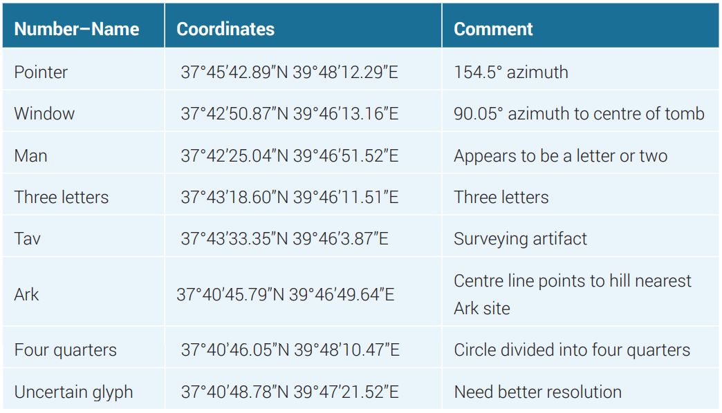
The terraced hills on the south end of Karaca Dag
Jubilees and Josephus both record the tradition that the survivors of the Flood lived atop the mountain for a century before they came down to build Babel. According to Jubilees, Cham went with his family to live separately after the nakedness incident and built a village on the south side of the mountain.22 We found ancient villages at the south and north ends of the mountain.

We found on the south end of Karaca Dag at peak no. 1 an ancient village with stone buildings, surrounding an acropolis topped with the remains of a domed room with a window facing southeast (figure 8). It lies within a 10 × 9 km terraced region with roads of similar construction to the grid at the north end of the mountain (figure 9).
The village on peak no. 1 may be the legendary city of Aratta, the ‘Throne of Ishtar’ (table 4). In the Sumerian Epic, Enmerkar and the Lord of Aratta, Enmerkar vies with the Lord of Aratta for the love of Ishtar, whom Johnson23 and Gill identify as Naamah, the daughter of Lamech in Genesis 5, and the first wife of Cham. As per John Gill’s commentary on Genesis 4:22:
“ … our Bishop Cumberland conjectures, that she was the wife of Ham, was with him in the Ark, and after the flood was the means of leading him into idolatry: what led him to this conjecture was, that he observed in Plutarch, that the wife of Cronus, the same with Ham, is by some called Nemaus, which brought Naamah to his mind.”24
En-mer-kar, whom Rohl identifies as Nimrod,25 tries to lure her down from Aratta on the mountain to his beautiful brick built ‘Kulaba’, which is a city and temple.

Table 4. First Neolithic villages
This epic is probably a memory of Nimrod attempting to persuade his grandmother Naamah that it was safe for her to come down from the mountains of Ararat and live in the city of Erech, which he built for her along the Tigris River in the land of Shinar. The sites we propose as Babel and Erech are 52 to 66 km northeast of this site.
The terraced area is too cold and stony for farming. From satellite it appears to be currently cultivated land, but it is not. Only shepherds walk here today. The mountain of ‘Hiriki’ was occupied as late as the time of Tiglath Pileser I, who claimed to have stained it red with the blood of its inhabitants.26
The tomb and possible Ark site

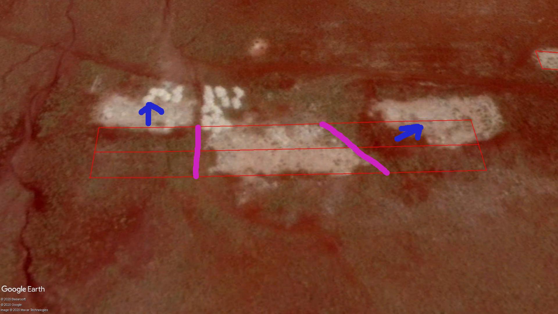
Centred between the grid of the north end of the mountain and the terraces of the south end we find the complex of buildings that we believe to be the landing site. Coordinates: 37°42’44.58”N 39°49’56.80”E (figure 10 and table 3).
Table 3. Objects on site

The site is near the centre of the widest part of the plateau, adjacent to peak 7 when counting from south to north. Peak 7 is a double or triple peak, depending on how you count it, with saddles between the hilltops. These peaks are now occupied by a television station, military radar base, and a weather radar station. The tomb is located on the saddle between the northern two hilltops.
The Tomb

The tomb has a central stone mastaba, 60 m2, facing the winter solstice at 113.5°. On the north and south sides are trapezoidal additions that make the entire structure resemble a gigantic stone canoe, about 160 m in length (figure 11).
The school buildings
East of the tomb lie the collapsed remains of the school presumed to have been built during Attaturk’s literacy drive around 1928.27 The US Air Force used the abandoned school as a temporary barracks in 1967 while they built the radar station on the nearby hilltop. They later demolished it with explosives. What remains is a rubble field of bricks and shattered concrete with protruding rebar. The school was composed of four buildings, which we have numbered 1–4.
Other features
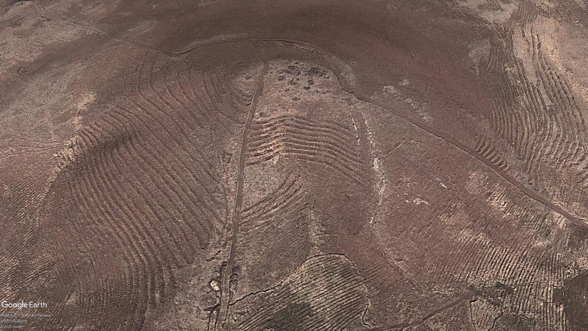
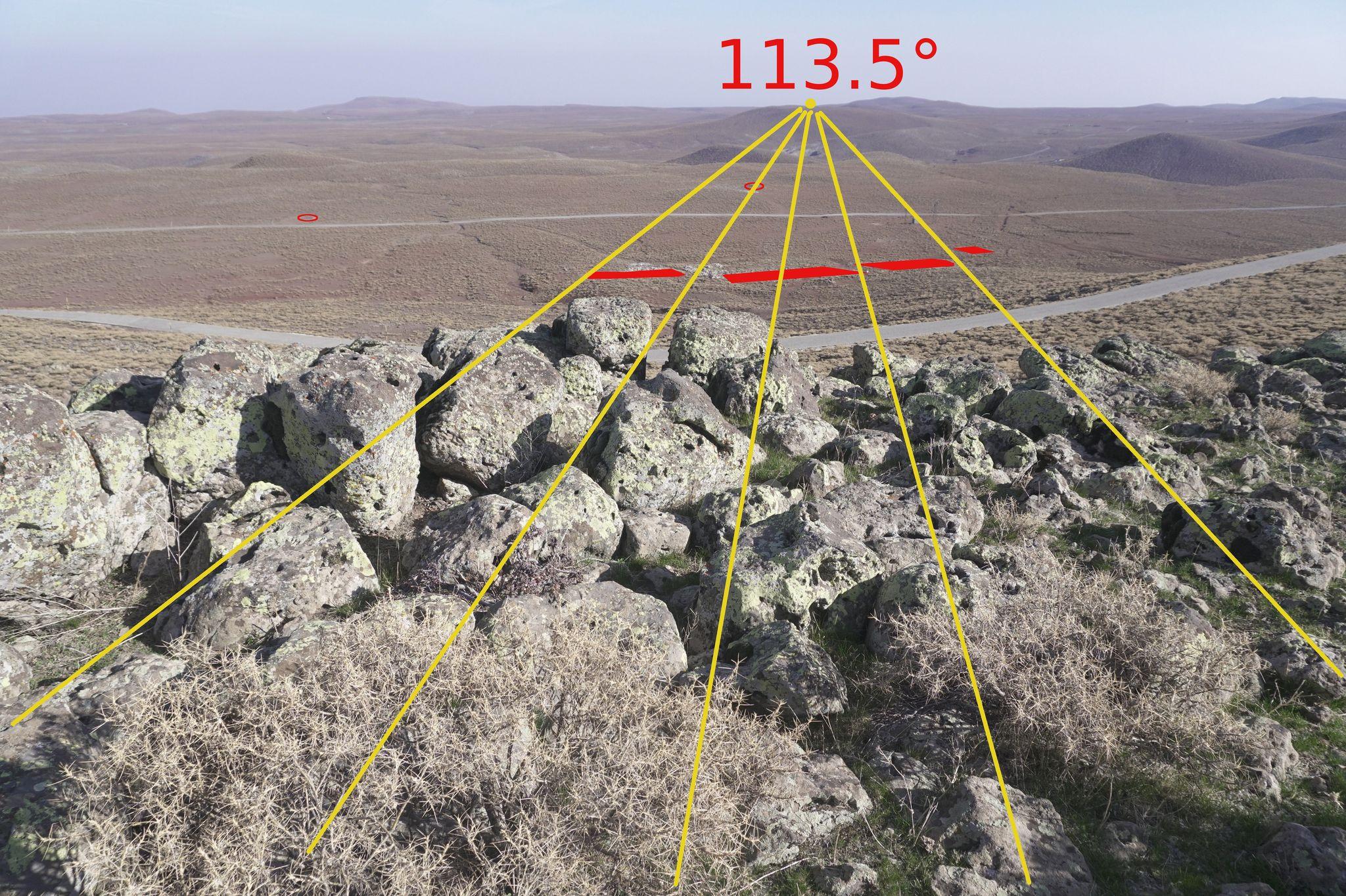
The smallest building on the school site is a square concrete slab, no. 4. Approximately 300 m due east of the slab is a circular pit with a rectangular shape dug out of it. We call this the gnomon pit, no. 6, because it appears to have been used to measure the direction of the sunrise.

Due north of the square slab is a small mound, no. 5, of different coloured earth with four small stone cairns. The azimuth from the cairns to the gnomon pit is 113.5°, which is the azimuth of winter solstice sunrise. The slab, gnomon pit, and cairns form a right triangle (figure 12).
340 m north–north-west of the gnomon pit is a circular depression fenced with stones that we called the ‘survey point’, no. 11. This point is aligned to the cairns and the gap between the two large school buildings at a 45° azimuth, to the corner of the square slab at 30°, to the north edge of the tomb at 270°, and the long axis of the rectangular gnomon pit. These azimuths cannot be random.
125 m south of object no. 1 there is a long trench, no. 14, dug into the hill. We think this is a recent ‘borrow pit’ used to get fill for the construction projects, because it cuts one of the ancient roadbeds.
There are about 20 bright white piles of rubble around object no. 3. Examination revealed them to be dump truck loads of broken concrete from a renovation project on the radar base above.
Interpreting the site
At first glance the tomb is interesting. The remains of the school are a mess. There is no obvious relationship between the two. However, careful study reveals the site to be laid out according to a geometric plan.

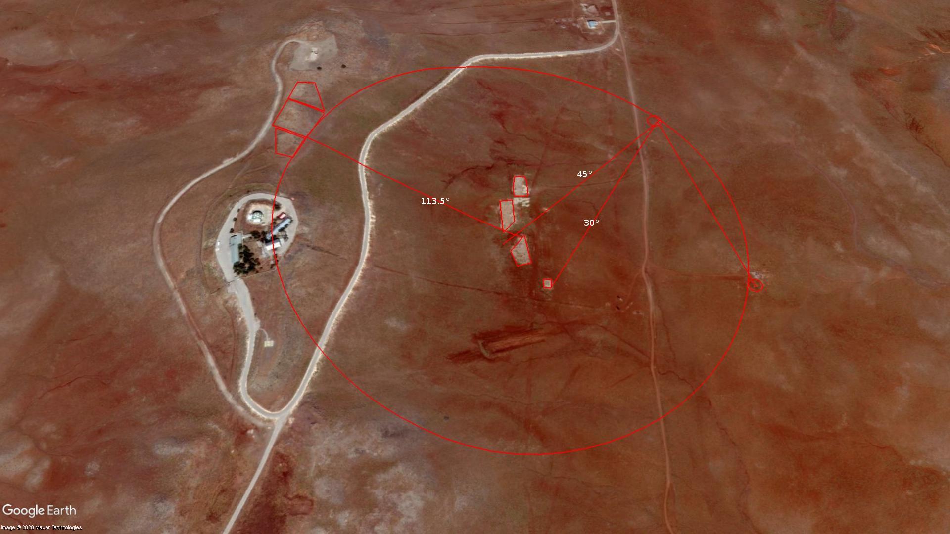
The solstice sight line from the gnomon pit to the cairns extends through the joint between buildings no. 2 and no. 3 up to the tomb, and along the northern edge of the square mastaba (figure 13).
The survey point seems to have a special relationship to the gap between buildings no. 1 and no. 2, as well as the altar, solstice mound, and gnomon pit (figure 14).

The gnomon pit, survey point, and the close edge of the tomb are equidistant from the centre of the gap between buildings no. 1 and no. 2 (figure 15).
Combining these observations together we found a geometric design that it appears was used to position the tomb in relation to the footprints of buildings 1–3 so that the winter solstice sunrise shines over whatever was previously there onto the tomb (figure 16). This strongly suggests that the 1928 school was built on top of something of the same age as the tomb, which appears to be thousands of years old.

The two extensions to the tomb are also aligned to the northern and southernmost edges of buildings 3 and 1, as well as the corner of 4, as shown in figure 17.
We recommend that readers make their own measurements using Google Earth Pro to test our findings, rather than attempting to use ratios directly from our illustrations, which are distorted by the 3D perspective algorithm in Google Earth.
Hypothesis—they cut the Ark in three pieces

Judging from the positioning of the tomb relative to buildings 1–3, we suspect the school buildings were built atop the gravel ballast of the Ark, long after all the wood had rotted away. Combining the three buildings gives a length of about 157 m, or 300 Egyptian cubits; and the width of the buildings is about 50 cubits. Grant us, for a moment, a speculation.
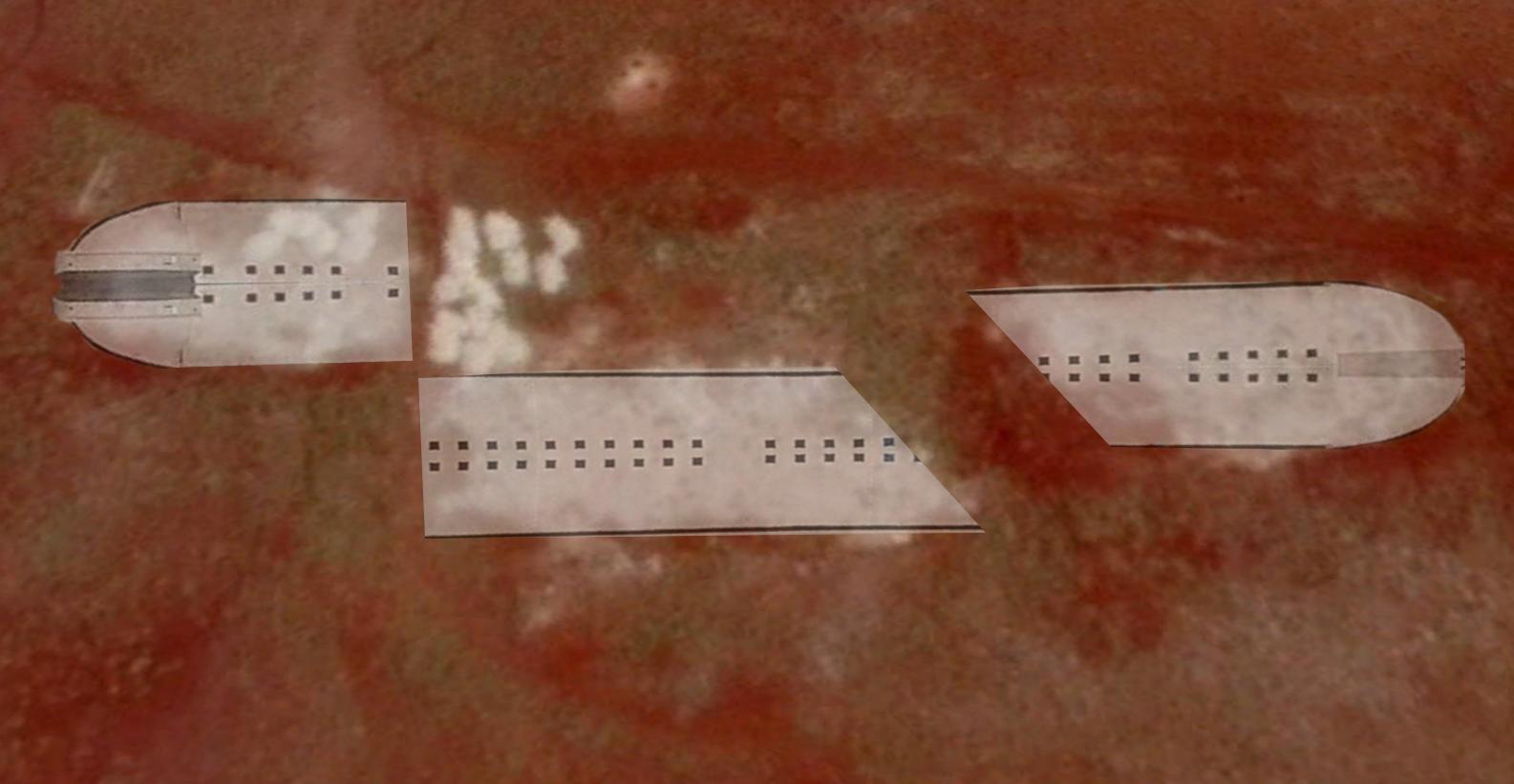
We have reason to believe that the draft of the Ark was 15 cubits, based on the report that the water covered the mountains to 15 cubits, and the height of the Ark was 30 cubits. Thus, the waterline was halfway up. The door in the side would have to have been above the waterline on the top deck.
When loading the Ark, the heaviest objects would be placed in the bottom deck for stability. Some particularly large or heavy objects might have been laid in the bottom deck while the vessel was still under construction. What objects might these have been? Perhaps there were one or more stone sarcophagi of the patriarchs, machines, stone jars, water tanks, vehicles, metal ingots, etc.
After the Ark landed, this arrangement would create a particular problem. The bulkiest and heaviest items on the bottom deck may have been difficult or impossible to get out of the door on the top deck.
From the layout of the buildings that we hypothesize were built upon the Ark remains, it appears that the ‘arkonauts’ severed the northernmost quarter of the Ark, and rolled it downhill just far enough to allow access to the interior. A poorly executed unjacking might have tipped the floor hard enough for the ballast gravel to slide to one side, making the gravel footprint that later became building 3 narrower than the others.

Since the second cut at 45° through the remaining long section of the Ark divides it into two roughly equal pieces, we surmise this cut was made later, perhaps at the time of the tomb construction. Section 1 was moved about 8 m downhill to the southeast, and may have been deliberately positioned.
We estimate the Ark would have required 1–2 m of gravel in the bottom as ballast. A gravel patch of such size and depth would allow a modern building to be built on top with minimal excavation. The foundation is typically one third of the cost of a building.
Buildings 1–3 are certainly not a typical design, and do not have 90° corners. Unless the architect was insane the shape of the school buildings appears to have been dictated by something that was already there.
The brick and concrete remains of the school would then approximate for us the previous location of the Ark sections. Soil cores will be required to prove that. We expect soil cores to reveal gravel down to a depth of about 2 m, with remains of the bottom deck below that. The wood would probably be gone. However, at minimum there would be a soil horizon stained with tannins, and possible remains of bitumen flakes.
If our speculation is correct, then there are two reasons to suppose that building 4 was built on top of Noah’s altar. First, the altar had to be near the Ark. Building 4 is the smallest, closest to the other three, and is square. Second, it was universal ancient practice to position altars so that the first rays of dawn shone on them at the equinox or solstice. The placement of the gnomon pit due east of building 4 suggests this kind of relationship.
Figures 18–20 show our hypothesis of how the Ark was cut into sections.
A method to the madness
We offer this simple hypothesis to explain the strange relationship of the tomb to the remains of the school.
God’s ‘rainbow covenant’ at the altar promised not to destroy the world again with water and that summer, winter, seedtime, and harvest would perpetually continue (Genesis 9).
By building the tomb so that the winter solstice sunrise shines over the altar and the Ark onto it, the tomb and the Ark were joined together into a clock made of stone. Every winter solstice sunrise, when the first ray of dawn shines over the altar and touches the tomb, it shows that God’s promise held true for another year (figure 21).
Winter solstice alignments are common in ancient temples, so the solstice alignment does not prove this is the Ark and tomb. But we can see why this alignment might have made sense to someone who wished to create a monument to commemorate Jehovah’s deliverance of mankind from the Flood and His new covenant with them.
Objections
Humphreys argued that since the Ark settlers came from the east, and since Sumeria was Shinar; therefore, the Ark must lie in the Zagros Mountains east of Iraq.28 Given the diversity of translations for Genesis 11:2, it might be safer to say Babel was on an east–west axis to the Ark site.
Humphreys assumed that Shinar was Sumeria. As shown in part I of this paper, there were several locations between the Tigris and Euphrates known by the name Shinar. One of them, Çınar, is east of this site.
Crouse9 and Habermehl29 maintain that Mt Judi was the Ark site. However, the majority of their arguments could just as easily apply to Karaca Dag.
The church fathers may have indeed known the location of the Ark up until the Muslim invasion. Whether the legends referred to Judi Dagh or Karaca Dagh is an open question. Alternatively, the legends about Judi Dagh may have been a case of mistaken identity even back then.
“The tops of the mountains were seen” six weeks after the Ark landed (Genesis 8:4–5).28 Karaca Dag is shaped like a large table. Though it is the highest mountain in 100 km, from the Ark site the surrounding mountains are not visible because they are below the rim of the plateau.
Assuming prevailing winds from the northwest at this latitude, the humid air blowing up the west side of Karaca Dag would be expected to condense, shrouding the mountain top in clouds. As the water receded out of the region, the humidity in the winds fell, and the mountain top was no longer shrouded in constant clouds.
The tops of the mountains they would have seen were Karaca Dag’s peaks 5, 6, 7, and 8 nearest to the Ark.
The river gravel could have been brought up from the Tigris Valley in trucks along with the bricks. We examined the aggregate in the concrete of the school and found a mixture of crushed white stone with jagged edges and small rounded river stones, many of which were black.
An architect would have prescribed the crushed stone for aggregate because it grips the cement better than smooth rounded river gravel. The question is where the builder obtained the river gravel. Was it from the site or from a river quarry in the valley below?
A study of nearby quarries will be necessary to rule out a local source of the river gravel.
Conclusions
The Epic of Gilgamesh says Enlil had designated the Cedar Forest on the mountain as a forest sanctuary called ‘The Land of the Living’. Gilgamesh went there to kill the guardian, Huwawa, and desecrate the place.20
We observed no evidence of farming or habitation around the tomb and Ark site. But the mountain is covered with such evidence 10 km north and south. It seems reasonable that Noah may have designated the site as a sacred precinct, the world’s first national park, a refuge around the Ark where no hunting was allowed. This would have allowed the animals to repopulate the earth, while allowing humans to hunt them outside the park.
Excavation will be required to confirm our identification of these sites. Here is a summary of the evidence:
- Anthropology—it is the mountain closest to the centre of the PPNA, and the Levantine Neanderthal distribution.
- Biology—the genetic ancestor of all strains of domesticated einkorn wheat is found on this mountain, along with seven other founder crops of the Neolithic revolution.
- Viticulture—the domestication of grapevines occurred on the North side of Karaca Dag.
- Etymology—the old name of the mountain is Masia, Masis, Mashu.
- Linguistics—geoglyphs with writing in an unknown script.
- Geography—the mountain is within the territory of the Kingdom of Urartu from 700 BC.
- Surveying—large geoglyphs, three of which point to the site, one looks like an Ark.
- Archaeology—evidence of human habitation and farming near the site at an elevation currently inhospitable to agriculture.
- Architecture—large stone tomb, roughly shaped like a boat, 160 m long.
- Archaeoastronomy—the tomb is oriented to the winter solstice sunrise.
- Geometry—the tomb, geoglyphs, and grid show knowledge of geometry and 30° angles.
- Geology—river gravel found on site, alien to the mountain.
Interpreting the Sumerian ‘Anunnaki’ as a case of ancestor worship, ‘Anu’ would appear to be a corrupted memory of Noah, whose name in Hebrew was NU. We conclude that Karaca Dag is probably the ‘sacred mountain of the Anunnaki’ where Gilgamesh went, and the sacred precinct was called ‘the land of the living’ because when they asked themselves what land they had come to, the only reasonable answer was ‘the land of the living’, because everyone else was dead.
Figure 22 shows an overview of the mountain with some of the grid lines, estimated sacred precinct, and the speculated ‘Aratta’ with its terraced region.
References and notes
- Heun, M., Site of einkorn wheat domestication identified by DNA fingerprinting, Science 278(5341):1312–1314, 1997 ǀ doi.org/10.1126/science.278.5341.1312. Return to text.
- Weiss, E. and Zohary, D., The Neolithic Southwest Asian founder crops: their biology and archaeobotany, Current Anthropology 52(S40):S237–S254, 2011. Return to text.
- Hotz, R.L., Scientists Follow a Grain to the Origins of Agriculture, Los Angeles Times, 14 November 1997, latimes.com/archives/la-xpm-1997-nov-14-mn- 53637-story.html, accessed 9 April 2021. Return to text.
- Deal, D.A., Noah’s Ark—the Evidence: Untying the knot of the Gordurian Mountains, Kherem LA Yah Pr, Irvine, CA, 2005. Return to text.
- Cornuke, R., and Halbrook, D., In Search of the Lost Mountains of Noah: The discovery of the real Mt Ararat, B & H Pub Group, Nashville, TN, 2001. Return to text.
- Creation Ministries International, Hong Kong group launches a movie on its claimed ‘Noah’s Ark discovery’ at the Sydney Opera House, 16 August 2011, accessed 9 April 2021. Return to text.
- Charles, R.H., The Book of Jubilees; in: The Apocrypha and Pseudepigrapha of the Old Testament, Clarendon Press, ch. 10, v. 15, 1913. Return to text.
- Wallis Budge, E.A. trans., The Book of the Cave of Treasures: A translation of the Syriac Text, The Religious Tract Society, London, p. 29, 1927. Return to text.
- Crouse, B., The landing place, J. Creation 15(3):10–18, 2001. Return to text.
- Alexander, R. and Knight, K. (Eds.), Ante-Nicene Fathers, vol. 5, Donaldson, J. and Coxe, A.C. trans., Christian Literature Publishing Co., Buffalo, NY, 1886. Return to text.
- Charles, ref. 7, chap. 7, v. 17. Return to text.
- Vouillamoz, J., Grapevine Domestication: why, how and where? In Search of the Grape’s Fertile Triangle, littlewine.co/blogs/editorial/grapevinedomestication2, accessed 5 August 2021. Return to text.
- Ömer, E. and Dolmaz, M.N., Tectonic escape mechanism in the crustal evolution of eastern Anatolian region (Turkey); in: Schattner, U. (Ed.), New Frontiers in Tectonic Research—At the midst of plate convergence, IntechOpen, 2011. Return to text.
- Pearce, J.A. et al., Genesis of collision volcanism in eastern Anatolia, Turkey, J. Volcanology and Geothermal Research 44(1–2):189–229, 1990. Return to text.
- Okay, A.I., Geology of Turkey: a synopsis, Anschnitt 21:19–42, 2008. Return to text.
- Snelling, A.A., Locating the Flood/post-Flood boundary using the relative dating of the weathering of ore deposits; in: Whitmore, J.H. (Ed.), Proceedings of the Eighth International Conference on Creationism, Creation Science Fellowship, Pittsburgh, PA, pp. 553–566, 2018. Return to text.
- Clarey, T.L., South Caspian Basin supports a late Cenozoic Flood boundary, J. Creation 33(3): 8–11, 2019. Return to text.
- Phillips, R. and Rix, M., Perennials, vol. 1, Pan Books Ltd, London, p. 216, 1991. Return to text.
- Holmberg, U., The Mythology of All Races: Finno-Ugric, Siberian, vol. 4, Cooper Square Publishers, New York, 1964. Return to text.
- Livingston, D.P., Who was Nimrod? Bible & Spade 14(3), 2001. Return to text.
- Sanders, N.K., trans., The Epic of Gilgamesh, Assyrian International News Agency Books Online, Penguin Classics, New York, 1972. Return to text.
- Charles, ref. 7, ch. 7, vv. 10–17. Return to text.
- Johnson, R.B., Genesis Characters and Events in Ancient Greek Art, Solving Light Books, Annapolis, MD, 2016. Return to text.
- Gill, J., Exposition of the Old and New Testaments: Complete and unabridged. Reprint edn, vol. 1, AK, Baptist Standard Bearer, Paris, 2006. Return to text.
- Rohl, D., Legend: The genesis of civilization, Arrow Books, Random House, London, pp. 206–207, 1998. Return to text.
- Luckenbill, D.D., Ancient Records of Assyria and Babylonia, vol. I, Historical Records of Assyria from the Earliest Times to Sargon, Histories & Mysteries of Man Ltd., London, p. 80, 1989. Return to text.
- Bozkurt, I., and Bozkurt, B., Yeni Alfabenin Kabülü Sonrası Mersin’de Açılan Millet Mektepleri ve Çalışmaları [tranls.: Public schools and their activities in Mersin after the adoption of the Latin alphabet], Çağdaş Türkiye Araştırmaları Dergisi, vol. Cilt: viii, no. Yıl: pp. 18–19, 2009. Return to text.
- Humphreys, R., Where is Noah’s Ark? a closer look at the biblical clues, J. Creation 25(3):6–8, 2011. Return to text.
- Habermehl, A., A review of the search for Noah’s Ark, Proceedings of the Sixth International Conference on Creationism, Institute for Creation Research, Creation Science Fellowship and Dallas, TX, pp. 485–502, 2008. Return to text.


Readers’ comments
Comments are automatically closed 14 days after publication.