

Journal of Creation 35(1):78–88, April 2021
Browse our latest digital issue Subscribe
Geochemical and related evidence for early Noah’s Flood year

This paper proposes a five-stage time sequence for the early part of Noah’s Flood year, with an emphasis on geochemistry. Early Flood year processes include the fountains bursting forth, enormous rain, and sea level rise. The Neoproterozoic to Cambrian stratigraphy of the Mackenzie Mountains of north-west Canada is well described in the literature. This location is used as a key example of strata inferred to have formed during the early Flood year. Neoproterozoic stratigraphy is subdivided upwards into Tonian, Cryogenian, and Ediacaran strata.
Early Flood year geological activity included major volcanics, huge amounts of continental erosion, deposition of sheet sandstones, mass flows, banded iron formations with high phosphate content, high volumes of nutrients, and the burial of diverse marine invertebrates. Chemical parameters used in this study include 87Sr/86Sr ratios, oxygen levels, lithology types, carbon isotopes, carbonate formation, the order of precipitation of barium and iron, phosphorus levels, sulfur isotopes, organic matter burial, and molybdenum isotope ratios.
Explaining the cause-effect relationships of the rock record at the interface between the Precambrian and Phanerozoic rocks is a complex task:
“Determining the geodynamic causes of extensive Neoproterozoic continental denudation followed by Phanerozoic sedimentation, and linking those dynamics to the timing and spatial distribution of marine transgression and biogeochemical change, is now a challenge for geoscience.”1
This paper seeks to address this challenge by invoking a framework of the early stages of the Flood year based on correlating inferred common geochemical processes to the biblical and geological records. Therefore, geochemistry should help clarify events and processes operative during the early phase of Noah’s Flood year.
An anticreationist geologist said:
“Sedimentation in the past has often been very rapid indeed and very spasmodic. This may be called the Phenomenon of the Catastrophic Nature of the Stratigraphical Record.”2
Many chemical reaction rates increase exponentially with increasing temperature.3 As such, chemical reactions can occur very rapidly under conditions such as hydrothermal activity. Even at room temperature, many chemical precipitation reactions necessary for mineral formation occur almost instantly.4 The rapidity of the basic chemical reactions involved is consistent with a young-earth creationist understanding of Earth history.
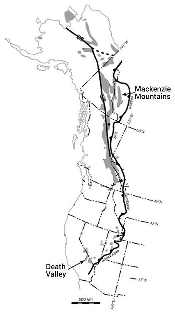
Broadly speaking, the initial Flood deluge would have caused enormous erosion of the land, and concurrently the sea level rose until eventually all the earth’s land was covered.5 This initial enormous erosion of land is an important aspect of the Flood year that must be recognized in conjunction with the marine transgressions of the Flood year.6 The Cordilleran stratigraphy of North America, and particularly the Mackenzie Mountains of Canada published by such researchers as Colpron et al.7 (figure 1) and Hoffman and Halverson8 (figure 2), serve as a good illustration of how these processes could rapidly form Neoproterozoic to Cambrian strata during the early stages of the Flood year. The abundant published studies written on this region that have geochemical relevance make it an especially useful example for closer analysis.
Discussion
The following is a proposed Flood model for the Mackenzie Mountains (figure 1) in five stages in approximate time order for the early Noahic Flood year. We maintain that the generally accepted secular deep-time ‘radiometric ages’ used in this paper are not absolute ages. In addition, we assert that the events described occurred some thousands of years ago, but in similar order as the referenced radiometric dates.
Stage 1
A. Pre-Flood sediments
The stratigraphic section of the Tonian Mackenzie Mountains Supergroup adapted from Hoffman and Halverson8 (figure 2) illustrates how the supergroup likely represents pre-Flood deposition in a large epicratonic basin9 (Stage 110). Detrital zircon provenance studies indicate that the Katherine Group quartz arenite was in part delivered by a continent-crossing early Neoproterozoic river system draining the mountains of Grenville Province in the south-east of North America.11 The Little Dal Group has giant microbial carbonate reefs,9 and the presence of sulfate ‘evaporite’ indicates the action of hydrothermal springs. These features suggest the presence of a hydrothermal biome on the pre-Flood continental shelf.12
B. Initial tectonism and volcanism
Consistent with Genesis 7:11 and Proverbs 3:20a, Noah’s Flood may have been initiated by God causing the mantle to heat in a cataclysmic global thermal-tectonic episode, cracking open the earth’s crust and driving out water to the earth’s surface. Secular scientists have found evidence of episodic rifting events at the margins of North America between 0.8 and about 0.6 Ga. These are thought to record the fragmentation of a Neoproterozoic supercontinent.13,14 This is consistent with the breaking open of the crust by the fountains of the great deep, followed by further continental extension and then ocean formation.
Mafic volcanic rocks record widespread igneous activity during regional rifting along western North America10 and the Cryogenian breakup of the supercontinent. Researchers have inferred that large continental flood basalts were emplaced when the supercontinent began to break up. A major example of this volcanism is northern Canada’s Franklin Large Igneous Province, which is over 2 million km2 in area.15
87Sr is a radiogenic daughter isotope of 87Rb and is found in silicate rocks such as granite, which are a significant part of continental crust. The abundance of radiogenic 87Sr relative to ‘common’ 86Sr in a sample of sediment is related to the amount of sediment that originated from the erosion of continental crust. Lowered 87Sr/86Sr values indicate hydrothermal and oceanic sources. In north-west Canada, a low 87Sr/86Sr value in early Neoproterozoic strata (ca. 830 Ma) has been correlated with a large input of juvenile crust and the Pan-African event.16 The Pan-African event relates to massive rifting on the Cordilleran and Appalachian margins of North America, as well as immense continental erosion and enormous water flows.17 In north-west Canada, breaking open of the crust enabled extensive volcanism, which intruded as far as the top of the Mackenzie Mountains Supergroup, where it formed pillow basalt lavas8 (figure 2).

The Little Dal Group (at the top of the Mackenzie Mountains Supergroup—figure 2) is inferred to be the highest pre-Flood formation in the Mackenzie Mountains (figure 1). The basalt which intruded the Little Dal Group (figure 2) is inferred to have formed as part of an ongoing extensional regime while the early Flood year fountains were active. Extension and intracratonic basin deposition (Stage 1 of figure 2) is thought to have occurred contemporaneously with the intrusion of the Franklin and Gunbarrel large igneous province dike swarms of northern Canada.10
The Coates Lake Group (the lowest section within the Windermere Supergroup—figure 2) is inferred to have been deposited on top of the Little Dal Group at the very beginning of the Flood year. The sandstone and siltstone-rich unit may have formed from sediments eroded from the land by the massive rainfall. A layer of sulfate18 within the Coates Lake Group formed when the heat from magma, welling up because of the igneous activity concurrent with the fountains erupting, led to CaSO4 precipitating from the waters. Along with the magma came hydrothermal fluids rich in CO2. Widespread and prolonged rain and fountains pouring forth (Genesis 7:11–12) caused enormous runoff. Dead organisms and other nutrients carried in the runoff provided food for microbes, which then helped convert the CO2 to carbonates (figure 2, Stage 2). The laminated, stromatolitic nature of the carbonate layer at the top of the Coates Lake Group supports this interpretation of its formation.19,20
The Coates Lake Group likely represents deposition in embayments of a rift system.9 It hosts significant strata-bound copper deposits in a series of half-grabens, which we suggest are related to the first stage of the supercontinent breakup.21 Chloride brines may have leached copper from the underlying Little Dal Basalt, and then passed through reducing sulfate-bearing strata of the Coates Lake Group, which triggered the precipitation of copper sulfides.21 This hypothesis is supported by the fetid, black carbonates of the Copper Cap Formation, which is the top part of the Coates Lake Group.8 The coarse-grained limestones have abundant sparry calcite cement with δC13 values near zero. These δC13 values suggest that the source of the sparry calcite cement is at least in part from CO2 produced by methane fermentation of organic material in the substrata.22 The reducing nature of these carbonates could have enabled the precipitation of the copper sulfide.
Enormous rainfall impacted the North American continent at this stage, causing increased erosion and the mass-flow deposition of coarser sediments, forming diamictite along with sandstone, siltstone, and mudstone (figure 2, Stage 2). These sediments characterize the Rapitan through Icebrook formations of figure 2. The Rapitan and Icebrook formations have respectively been correlated worldwide with the supposedly ‘glacial’ Sturtian and Marinoan strata.23 The finer-grained shale, sandstone, siltstone, and limestone of the Twitya Formation and the Keele Formation, which overlay the diamictite of the Rapitan, suggest a rising sea level.
The basal Twitya Formation has a cap carbonate overlying the Rapitan Group (figure 2).18 δ13C values suggest somewhat higher input of inorganic carbon to the carbonates of the Keele and Ravensthroat formations compared to the carbonate in the Coates Lake Group. This indicates a fresh input of inorganic carbon from volcanic hydrothermal fluids containing carbon dioxide, which led to oversaturation of carbonate and precipitation of calcite and aragonite, some of which later underwent diagenic dolomitization.24,25 However, the still increasing 87Sr/86Sr ratio indicates a significant amount of this carbon may be from continental carbonates that were eroded into the basin as well. It has been proposed that some cap carbonates formed both by microbially mediated precipitation during algal blooms under low salinity conditions and by direct precipitation of aragonite unto the seafloor.25 The presence of flakestone provides additional evidence for extensive calcium carbonate precipitation.
Stage 2
A. Enormously powerful and destructive continental erosion
The Noahic rain event (Genesis 7:12) was the greatest rain event ever recorded in the history of the earth. Erosion was consequently immense and powerful enough to erode and peneplane hard crystalline basement rocks around the globe and wear mountains down.6,17 The modern-day canyon formed in the spillway of California’s Oroville Dam demonstrates that water is powerful enough to rapidly erode even hard crystalline rock.26 We infer an enormous erosion of land associated with the early Flood year’s rain.5

Figure 3. Summary of major geochemical and sedimentary patterns derived from Neoproterozoic to Ordovician strata. There is a shift from widespread continental denudation to widespread sedimentation on the continents (after Peters and Gaines1). We infer that:
- The observed increase in the Neoproterozoic strontium isotope ratio 87Sr/86Sr can be explained by accelerated rates of denudation due to the impact of the early Flood’s rain on the supercontinent and to associated Pan-African event tectonism. The Sturtian (S) and Marinoan (M) supposed ‘glaciations’ are instead times of massive mass flows due to enormous runoff caused by the colossal rain of the early Flood year.5,6,17
- The subsequent decline in 87Sr/86Sr ratio in post-Cambrian strata is associated with the first continental-scale marine transgression of the Phanerozoic.1 The supercontinent was covered with ocean so that the Flood’s rain no longer had a direct impact on the land.5,6,17
The significant Neoproterozoic 87Sr/86Sr isotope ratio increase as reported by Peters and Gaines1 and reproduced in figure 3 is consistent with enormous erosion of notably radiogenic continental crust1,5,6,24,27,28 during the Pan-African event.29 The ‘radiometric timespan’ for this increase in 87Sr/86Sr ratio is approximately 0.4 Gyr (between 0.9 Ga and 0.5 Ga, i.e. early Neoproterozoic to mid-Cambrian—figure 3), but in the biblical framework the actual time elapsed would have been of the order of weeks to months. This ‘radiometric timespan’ likely represents the time from the initiation of Noah’s Flood (associated with fountains hydrothermal activity) and massive continental erosion caused by rain, to a time of greater oceanic influence with accumulation of sediments on the continents as the Sauk sequence began to be deposited.5,1787Sr/86Sr ratios in Cambrian sedimentary carbonates are the highest of Phanerozoic strata.30,31 High crustal erosion rates have been inferred from Cambrian 87Sr/86Sr values in north-west Canada.16 The large supplies of clastic sediments that flooded into basins imply high rates of erosion of the basin hinterlands, which in turn can explain the progressive rise in 87Sr/86Sr (figure 3).
Detritus resulting from continental erosion was entrained in flowing water, which produced Neoproterozoic sedimentary cover sequences.17 This included thick sedimentary successions found in North America’s Cordilleran region. Zircon grains of Grenvillian age (1.0–0.9 Ga) were recovered from lower Neoproterozoic sedimentary basins in north-western Canada, more than 3,000 km away from the nearest source in the Grenville Province on the other side of the continent.11
The pre-Flood earth and its people were destroyed during the Flood year (Genesis 6:13) in the sense of its topography and people being totally wiped away (Matthew 24:39). This drastic transformation began with an enormous erosional event from the early Flood year’s prolonged and globally extensive rain. Early in Noah’s Flood year, even high mountains were eroded down and peneplaned. Today’s Grenville, Mazatzal, and Yavapai provinces in south-eastern North America are considered to be examples of the roots of eroded mountains.6,32
B. Cryogenian mass flows
Enormous torrential rain is inferred to be responsible for initial massive subaerial sheet erosion of the continental landmasses. This was followed by huge submarine mass flows, depositing immense volumes of sediments, as the Flood advanced.17 In contrast to lower Neoproterozoic sheet sandstones, mid-Neoproterozoic (Cryogenian) sequences contain poorly sorted diamictites, so-called ‘glacial’ deposits, 14 especially on continental margins such as North America’s Cordilleran.33-35 These ‘glacials’ are instead considered to represent submarine landslide deposits33-35 along active tectonic zones as the marine transgression of the Flood year progressed. Cryogenian deposits are mainly poorly sorted immature clastic sediments, with lesser volcanic rocks.
Cryogenian ‘glacials’ have a close association with sedimentary rocks formed in warm climates.36 Warm, not cold conditions have been interpreted from associated kaolinite, diaspore, redbeds, dolomite, and limestone with phytolites,37 as well as abundant carbonates with stromatolites and carbonate ooids.38 Flakestone, a very distinctive fine-grained carbonate facies with its characteristic broken-up clasts, is an indicator of the action of stormy seas39 and not an ice-covered sea. Structures interpreted as giant wave ripples (generated by sea surface waves) have been observed in cap carbonate rocks from the Mackenzie Mountains, as well as Australia, Brazil, Namibia, and Svalbard.40 Waves would not have been possible in an ice-covered ocean. The ubiquitous association of Neoproterozoic iron formations with thick successions containing numerous levels of rounded dropstones in Canada, Australia, Brazil, and Namibia indicates that mixing across a redoxcline occurred repeatedly during a sustained interval of energetic hydrological cycling, which is incompatible with a globally static ice cover.25 We regard the Cryogenian Snowball Earth hypothesis as seriously flawed.
Transfer of atmospheric carbon dioxide to the ocean during rifting would enable rapid precipitation of calcium carbonate in warm surface waters, producing the cap carbonate rocks over Cryogenian diamictites which are observed globally. 25 Carbon dioxide build-up from active Flood fountains is believed to have contributed to the rapid precipitation of calcium carbonate discussed earlier.
Massive erosion and deposition due to early Flood year rain is inferred to have rapidly laid down Cryogenian strata. Submarine landslides are indicated by diamictites in the Rapitan Group and Ice Brook Formation. The Rapitan Group (figure 2) consists of diamictite, debris flow deposits, turbidites, siltstone, shale, sandstone (including arkosic sandstone), and volcanics, as well as banded iron formation. 17,41-43 Rapitan iron formations are found in extensional grabens that are associated with the initial breakup of the supercontinent, and are commonly found in association with mafic volcanics. Geochemical data indicates that Rapitan iron formations resulted from mixing between hydrothermal and detrital components, while rare earth element data indicates substantial interaction with seawater.43
Overlying the Rapitan Group is more Cryogenian strata, including shallower-water carbonate and siliciclastic strata of the Keele Formation, and the “glacial-related” Ice Brook Formation (figure 2).21 The Ice Brook Formation has ‘hotel-size’ megabreccia (figure 2). These so-called ‘glacials’ may represent a second phase of mass flows early in Noah’s Flood year.
The geochemistry of cap carbonates around the world carries a strong hydrothermal signal.36 Consistent with this, Canadian Neoproterozoic diamictites are marked by negative δ13C carbonate and correspondingly depleted δ13C organic and lower 87Sr/86Sr.44 Dissolved CO2 from hydrothermal fluids and volcanic activity would have provided a significant source of inorganic carbon, overshadowing even the effect of massive burial of organic carbon that was occurring throughout the Flood year. The 87Sr/86Sr ratio of hydrothermal fluid is lower than that of seawater and continental crust.45,46 There is an overall Neoproterozoic to Cambrian trend of rising 87Sr/86Sr values due to enormous continental erosion (figure 3). However, at times the hydrothermal input caused some dips in the overall trend of increasing 87Sr/86Sr values for Neoproterozoic strata.
C. Cryogenian barium, iron, and phosphorus occurrence
The most specific and typical feature of Cryogenian strata globally is the occurrence of so-called ‘glaciogene’ rocks from two stratigraphic levels. The upper or Marinoan ‘glacial’ is usually overlain by sediments with a higher concentration of barium. In the Mackenzie Mountains example (figure 1), Ravensthroat dolostone caps the Ice Brook Formation (figure 2) and contains a layer of BaSO4.18 The lower or Sturtian ‘glacial’ (such as the Rapitan in figure 2) is commonly associated with sheet deposits of iron ores and basic volcanics.44
This appearance of a barium layer several levels above an iron formation is common.44 We believe this indicates that all the Cryogenian sedimentary layers (between the iron and the barium) must have been deposited rapidly. Hydrothermal fluids characteristically contain iron, barium, and sulfide. If these mixed with seawater above wave base, atmospheric oxygen could oxidize iron and sulfide. Iron oxide deposition in the form of hematite in both Sturtian and Marinoan strata implies a build-up of ferrous (Fe2+) iron in seawater and subsequent mixing of deeper, suboxic water with shallower, more oxidizing water.25
Fe2O3 is significantly less soluble than BaSO4. However, both are highly insoluble and would be expected to precipitate from the water almost as quickly as they formed.4,47 The presence of the iron oxides stratigraphically beneath the barium sulfate suggests bacterial action increased the rate of Fe oxidation. The oxidation rate of both Fe(II) and sulfide is variable based on pH and bacterial action.48,49 Despite the lower solubility of Fe2O3, if the BaSO4 formed first it would precipitate first. In this specific environment, the presence of Fe(III) oxides below BaSO4 indicates that the oxidation of the iron was concurrent with or preceded the oxidation of the sulfide, suggesting bacterial action may have encouraged the conversion of Fe(II) to Fe(III). However, it is unlikely that the sulfate took significantly longer to form than the iron oxides. This suggests that the layers between the Rapitan and Ravensthroat were deposited very quickly.
Venting of hot fluids into cold neutral seawater causes rapid quenching and supersaturation, enabling the immediate precipitation of colloidal particles of ferrous hydroxide and hydrous ferrous silicate. The episodic character and rapid deposition of turbidity and density currents, lasting a few hours to days, is in direct contrast to the slow deposition of annual micro-laminations over millions of years inferred by earlier models for the origin of banded iron formations.50
During and immediately after the older, Sturtian ‘glacial’, the deeper parts of the ocean are inferred to be anoxic and with sufficient ferrous iron to sequester very large amounts of sulfur derived from bacterial reduction of sulfate. A huge shift in the sulfur isotopic composition was global, and this is inferred to have been accompanied by the reduction of as much as half the sulfate in the anoxic parts of the oceans.44
A pouring out of volcanics and associated hydrothermally formed banded iron formations in the Neoproterozoic occurred catastrophically in the early Flood year. The main iron oxide mineral in Rapitan-type BIF is hematite (Fe2O3) and this may have appeared blood-coloured.17,37,51
The rift-related Rapitan Group (figure 2) hosts billions of tonnes of phosphatic stratiform iron formations21 and associated diamictite. Rapitan Group iron formation, in common with other Cryogenian iron formations, has much higher phosphate contents than Paleoproterozoic and Archean iron formations.8 This indicates unusually high dissolved phosphate concentrations and is related to high rates of primary productivity and organic carbon burial.52
The greatest global phosphogenic episode in geologic history occurred in Late Precambrian and Cambrian time.53 It is noteworthy that all continents except Antarctica, to date, are known to have Precambrian-Cambrian transition sedimentary phosphate. These phosphorite deposits are generally found stratigraphically above Cryogenian diamictites, as well as generally below shelly fossils.37 Precambrian-Cambrian transition phosphorite is associated with catastrophic ocean water mixing (deep anoxic and shallow oxic oceanic waters), as inferred from sulfur isotopes.54,55 Upwelling of hydrogen sulfide-rich deep ocean water to become surface waters at the Precambrian-Cambrian transition is indicated by the basal Cambrian black shale molybdenum isotope signal.56 Upwelling currents are inferred to have supplied phosphate-rich waters to continental shelves where phosphorites were deposited around the world.39 The very active Flood fountains of the great deep would have caused catastrophic mixing of deep and shallow waters.27,57
Stage 3: Ediacaran: oxidation/reduction
It has been claimed that there was a rise in atmospheric oxygen in the Ediacaran (late Neoproterozoic), and that this was related to tectonism.58 This inferred episode of increased atmospheric oxygen is called in the secular literature the “Neoproterozoic Oxygenation Event” (NOE).17 However, in a YEC model of Earth history, the atmosphere already had to have oxygen levels comparable to modern times since the earth was full of human and animal life.
We do not believe the so-called NOE interval represents a massive increase in atmospheric oxygen. Rather, the increase in oxidized species in the stratigraphic record may simply indicate the movement of elements in a reduced state (such as S-2, Fe2+, and CH4), from deeper water to above wave base where they underwent oxidation by atmospheric oxygen. The very active Flood fountains of the great deep could have caused catastrophic mixing of deep and shallow waters.27 Across the globe, it is likely that anoxic seafloor sediment was brought to the surface while near-surface material was suddenly buried. We infer that the resulting near surface oxidation of reduced sediments was the source of the supposed NOE.
Simultaneously, buried organic carbon would have undergone decay, depleting waters of oxygen and creating localized reducing conditions in some areas and at some time periods. Careful study of the redox proxies used to support the NOE, such as δ82/76Se values,59 redox-sensitive element enrichment and sulfur isotope ratios,60 cerium-anomaly values,61 and δ238U62 all reveal just such a pattern. Rather than one dramatic and steady oxygenation event, the evidence shows multiple cycles of both oxidation and reduction, with a general pattern of oxygenated surface waters overlaying anoxic waters characterized by organic decay.60 This pattern is consistent with trends in δ13C for these sediments.62 Rather than a single oxygenation event, the Neoproterozoic waters were characterized by a complex and fluctuating redox chemistry, while the atmosphere maintained a relatively high oxygen content, similar to today.
Stage 3 (Ediacaran) (figure 2) is considered to represent lithospheric cooling following Cryogenian rifting.10 Ediacaran strata in the Mackenzie Mountains include shale and turbidites of the Sheepbed Formation, carbonate strata of the Gametrail Formation, thick terrigenous, clastic strata of the Blueflower Formation, and carbonate dominated rocks of the Risky Formation.21 Based on sedimentary facies, these Ediacaran formations are thought to have formed in marine environments with water depths ranging from deep (continental-slope) to shallow (areas of wave action).9
Mass mortality and a sudden decrease in biological productivity prior to the ‘Cambrian explosion’ (the lowermost appearance of shelly fossils in the stratigraphic record) has been inferred from a negative δ13C global geochemical anomaly in carbonate-containing black shale at the Precambrian-Cambrian transition. Kimura and Watanabe63 claimed that this corresponds to the widespread development of an oxygen-deficient (anoxic) shallow marine environment—a “Strangelove ocean”.64 We suggest that this relates to the consumption of oxygen in shallow waters due to the presence of dissolved organic material undergoing decomposition. This dissolved organic material has been inferred to include that derived from pre-Flood animals and some shelly invertebrates. 27 Vertebrate decomposition uses oxygen from the surroundings,65 creating anoxic conditions.
Stage 4: Immature siliclastics and volcanics
This stage is characterised by continuing erosion as evident by the increasing 87Sr/86Sr ratio trend for North America which reached a peak within Cambrian strata1 (figure 3). As mentioned in Stage 1, the abundance of radiogenic 87Sr relative to ‘common’ 86Sr in a sample of sediment is related to the amount of sediment that originated from erosion of continental crust as opposed to that originating from the ocean. In other words, the strontium isotope ratio 87Sr/86Sr is linked to runoff caused by erosion. This runoff in turn is related to the amount of rainfall and to tectonism. At times of lower rainfall there is less runoff, and conversely with more rainfall more runoff occurs.66 “Tectonic setting is the principal controlling factor of lithology, chemistry, and preservation of sediment accumulations in their depocenters, the sedimentary basins.”67 In summary, the greater the topographic relief due to tectonism, and with more rain, the more the runoff and greater volume and thickness of sediment deposited.
In the Mackenzie Mountains the Neoproterozoic strata is over 10 km thick (figure 2). This huge thickness of strata is consistent with the effects of Pan-African event break-up tectonism, active fountains of the great deep and enormous rain in the early Flood year, commencing with Stage 1. Water and entrained detritus flowed downward towards the continental margins where there is now thick Neoproterozoic strata. Sea level in the pre-Flood seas would have risen at the same time as the adjacent land was being massively eroded, until eventually the whole globe was covered with water and the rain no longer directly impacted the land. Sea level rise indicated by North America’s Sauk Megasequence is inferred to follow the initial break-up of the supercontinent.68
The continuity of the basal Sauk sandstone layer across North America is a testimony to the extent and uniformity of the first great marine transgression of the Phanerozoic.69 In the Mackenzie Mountains of Cordilleran Canada this sandstone is represented by the Backbone Ranges Formation9 (figure 2). Lower Cambrian strata correspond to the onset of the first major Phanerozoic marine transgression preserved extensively in North America at the base of the transgressive Sauk Megasequence, which culminated in the Great American Carbonate Bank.70
Marine transgressive deposits can be recognised through an upward deepening of facies.71 In addition to North America, evidence of sea level rise is provided by a universal fining upward sequence that has been observed in other Cambrian and Lower Ordovician (Sauk Megasequence) strata around the world including Greenland, UK, Russia, Australia, Bolivia, and Ghana.72 A classic fining upward succession occurs in Grand Canyon Cambrian strata (Tapeats Sandstone then Bright Angel Shale). Similarly, in Stage 4 of the Cambrian of the Mackenzie Mountains, the Backbone Ranges Formation sandstone is succeeded by the Vampire Formation mudstone (figure 2). “Global or worldwide marine transgression” is the descriptor in the secular literature.55 This is another way of saying global flooding!
Fluctuations in carbon dioxide levels during Stage 4 are considered to be related to the fluctuating opposing influences of volcanic release73 versus consumption with the weathering process.1 It has been inferred that, during Stage 4, rifting of the supercontinent and associated volcanism led to separation and transition to drift with the opening of an ocean basin in the west of Cordilleran North America.10
Stage 5: Early Paleozoic sea and carbonates
Subsidence histories of passive margins are a key indicator of worldwide continental extension and then ocean formation beginning at 0.6 Ga.13 Cambrian (through Devonian) strata of the Mackenzie Mountains were deposited on Neoproterozoic strata in a developing passive margin which underwent thermal subsidence.10 An expansive Paleozoic siliciclastic-carbonate passive margin was established,9 beginning with Stages 4 and 5 (figure 2).
We acknowledge and commend the great amount of work that fellow creationists Tim Clarey and co-workers have done in mapping the thickness and extent of megasequences on several continents.74 This data compilation was used to infer a sea level curve based on the assertion that the lateral extent, volume, and thickness of the megasequences relates to the height of sea level.75 For instance, they inferred that the lesser lateral extent and volume of sediment in the Sauk Megasequence indicates minimal flooding.76 However, these assertions regarding height of sea level and amount of flooding are refuted by numerous lines of evidence. 87Sr/86Sr ratio and sedimentary thickness curves correlate77 because both curves are a function of runoff. As mentioned in Stage 4, runoff and therefore the thickness and volume of sediment, is related to tectonism and rainfall.
The great thickness of Neoproterozoic strata (over 10 km in Stages 1–3) (figure 2) due to rain and powerful tectonism was followed by much thinner Cambrian strata (Stages 4 and 5) (figure 2). During marine transgression, such as in the Cambrian, the coastline moved landwards and the marine area enlarged. This is accompanied by a reduced sediment influx to the basin.71 Water rising in Stage 4 meant less area with direct impact by rain and so less sediment influx and less powerful erosion. Times of sea level rise over land are marked by an excess of carbonates over siliclastics.66 This can be seen in Stage 5 with the Great American Carbonate Bank.
Major oil companies find sea level curves to be invaluable in petroleum exploration since they provide useful models to help predict the location of reservoir rocks and petroleum source rocks. Researchers at Exxon were among the first to develop global sea level curves using seismic stratigraphy, based on oil exploration seismic and well data from around the world.78 The Exxon sea level curve rises in the Cambrian to a peak at the end Cambrian. Subsequently, others refined Exxon’s curve and interpreted global sea level to have risen in the Cambrian to an Ordovician peak.79,80
Haq and Shutter used reference geological sections from North America, Australia, northern and southern Africa, north-western Europe, and China to develop their curve for the Paleozoic. This augmented earlier results from subsurface data and the stratigraphic interpretation method of Exxon. Quantitative data from paleontology demonstrated increased diversity of plankton and pelagic organisms with higher sea level.81 The global Cambrian to Ordovician increase in marine invertebrate genera has been related to increased habitat area as the rising sea level transgressed the land.66,82 During sea level rise and maximum flooding of continental shelves, increased biological productivity, combined with greater preservational potential for organic matter in the expanded and deeper lower oxygen zone, make such sediments most likely locations for petroleum source rocks.81 In addition to seismic stratigraphy, Hallam used additional techniques such as paleogeographic mapping, occurrence of depth-related invertebrate and algal groups, glauconite concentration and facies correlation to develop sea level curves for the Phanerozoic.79
Drowning of cratons has been inferred from lithofacies changes in uppermost Proterozoic and Cambrian strata around the world. Peritidal carbonate platforms were drowned, to be followed in places by phosphorites and then black shales which form in deeper water.83 This drowning of cratons has been inferred to correlate with the time Noah’s Ark rose and floated on the waters.27
Consistent with the above-discussed independent lines of evidence (seismic stratigraphy, fossils, and sedimentary facies), the decline in 87Sr/86Sr ratio after the peak in Cambrian strata1 (figure 3) is inferred to be due to ocean formation, 13 such that the enormous rain of Noah’s Flood no longer directly impacted the land.5,17 In other words, by Stage 5 rising water in the early Flood year covered the land.
Deposition of the Sauk Megasequence of north-western Canada occurred along a complex segment of the rifted western margin of North America.84 The Great American Carbonate Bank comprises the carbonates (and related siliciclastics) of the Sauk Megasequence, which were deposited on and around the North American continent during Cambrian through earliest Middle Ordovician, forming one of the largest carbonate-dominated platforms of the Phanerozoic. 85 Although the term ‘Great American Carbonate Bank’ is understood to have originally just been used for the North American continent, the term has also been used elsewhere, such as in western South America,86 as well as Scotland and Greenland.87 Cambrian carbonate-rich strata, such as the Sekwi Formation of the Mackenzie Mountains (figure 2), accumulated in an extensive shallow epicontinental sea as siliciclastic sources were covered during the Sauk marine transgression.10
While carbonates were forming throughout the Flood, precipitation of carbonate sediments reached a peak in the Cambrian-Lower Ordovician strata of the Sauk sequence of North America.88 Petrographic textures (displasive growth of calcite crystals within the claystone matrix) and depleted δ13C values provide evidence of rapid direct precipitation of carbonate at the sediment-water interface.1 The ‘Cambrian explosion’ of organisms with carbonate skeletons and the proliferation of bioturbating organisms are coincident with the onset of a carbon cycle with isotopic fluctuations damped in both frequency and amplitude.44
The Cambrian-Lower Ordovician peak in carbonate formation may possibly have been enhanced by input of fresh rainwater along with high concentrations of carbon dioxide. Although we infer that Flood waters had completely covered the land, continuing rain may have contributed a significant amount of freshwater, which is more favourable for carbonate precipitation than seawater. Simultaneously, CO2 input may have peaked as the Cambrian has been inferred to have the highest modelled atmospheric carbon dioxide concentrations of the Phanerozoic.89
Conclusions
Geochemical processes played a significant role early in Noah’s Flood year. We have proposed a time sequence of early Noah’s Flood year including various items of evidence, with an emphasis on geochemistry of North America. Early Flood year processes discussed include fountains bursting forth, enormous rain, and the timing of sea level rise.
The Neoproterozoic to Cambrian stratigraphy of the Mackenzie Mountains of north-west Canada is used as an example (figure 1). Early Flood year geological products are inferred to include volcanics, huge continental erosion, sheet sandstones, mass flows, banded iron formations with high phosphate content, nutrients, and marine invertebrate diversity.
Backed up by evidence, we infer key differences to current common secular views of Neoproterozoic geological history:
- So-called ‘evaporites’ in Little Dal Group and Coates Lake Group formed by hydrothermal means, rather than by subaerial evaporation.
- Cryogenian diamictites formed by mass flows rather than by ‘glaciation’ and a ‘Snowball Earth’.
- Neoproterozoic oxidation of sediments due to vigorous upwelling and mixing of suboxic sediments associated with energetic Flood fountains, rather than the ‘Neoproterozoic Oxygenation’ of the atmosphere.
- Deep-time is unnecessary and unrealistic for geochemical reactions (such as formation of BIF and copper sulfide orebodies), particularly under hydrothermal conditions.
Key inferences in time order:
- The Mackenzie Mountains Supergroup represents pre- Flood deposition in a large epicratonic basin. Katherine Group quartz arenite was in part delivered by a continent-crossing early Neoproterozoic river system draining the mountains in the south-east of North America. Sulfate ‘evaporites’ of the Little Dal Group indicate the action of hydrothermal springs in a hydrothermal biome on the pre-Flood continental shelf.
- The bursting forth of Flood fountains is indicated by extensional tectonism and associated large igneous province activity and intrusives into the Mackenzie Mountains Group.
- Early Flood year’s enormous rain caused huge continental erosion, consistent with the Sr ratio trend upwards from the Neoproterozoic to Cambrian. This erosion was powerful enough to wear down crystalline basement rocks.
- Supposed ‘glacials’ in the Cryogenian strata (Rapitan Group and Ice Brook Formation) are considered to have formed as mass flow deposits associated with downslope water movement in early Noahic Flood times.
- Rapitan phosphatic BIF formed hydrothermally in association with volcanic activity.
- Carbonate-rich marine Cambrian strata formed in North America and some other continents as the sea transgressed the land.
- Sr ratio decreased post-Cambrian as the land was covered by water and the rain was not directly impacting the land.
- Cambrian to Ordovician increasing sea level and increase in marine invertebrate diversity.
A possible application for further investigation is to use geochemistry to help distinguish other phases of the Flood event year, such as marine regression and drying phases.
References and notes
- Peters, S.E. and Gaines, R.R., Formation of the Great Unconformity as a trigger for the Cambrian Explosion, Nature 484(7394):363–366, 2012. Return to text.
- Ager, D.V., The Nature of the Stratigraphical Record, John Wiley, New York, 1973. Return to text.
- Laidler, K.J., The development of the Arrhenius equation, J. Chemical Education 61(6): 494–498, 1984. Return to text.
- Kennedy, J., Analytical Chemistry: Practice, Saunders College Publishing, New York, 1990. Return to text.
- Dickens, H., The ‘Great Unconformity’ and associated geochemical evidence for Noahic Flood erosion, J. Creation 30(1):8–10, 2016. Return to text.
- Dickens, H., Colossal water flows during early Creation Week and early Flood, ARJ 10:221–235, 2017. Return to text.
- Colpron, M., Logan, J.M., and Mortensen, J.K., U-Pb zircon age constraint for late Neoproterozoic rifting and initiation of the lower Paleozoic passive margin of western Laurentia, Canadian J. Earth Sciences 39(2):133–143, 2002. Return to text.
- Hoffman, P.F. and Halverson, G.P., Neoproterozoic glacial record in the Mackenzie Mountains, northern Canadian Cordillera; in: Halverson, A.E., Halverson, G.P., and Shields-Zhou, G. (Eds.), The Geological Record of Neoproterozoic Glaciations, Geological Society, London, Memoirs 36:397–411, 2011. Return to text.
- Martel, E., Turner, E.C., and Fischer, B.J. (Eds.), Geology of the central Mackenzie Mountains of the northern Canadian Cordillera, Sekwi Mountain (105P), Mount Eduni (106A), and northwestern Wrigley Lake (95M) map-areas, Northwest Territories, NWT Special Volume 1, NWT Geoscience Office, 2012. Return to text.
- Yonkee, W.A., Dehler, C.D., Link, P.K., Balgord, E.A., Keeley, J.A., Hayes, D.S., Wells, M.L., Fanning, C.M., and Johnston, S.M., Tectono-stratigraphic framework of Neoproterozoic to Cambrian strata, west-central US: protracted rifting, glaciation, and evolution of the North American Cordilleran margin, Earth-Science Reviews 136:59–95, 2014. Return to text.
- Rainbird, R.H., McNicoll, V.J., Thériault, R.J., Heaman, L.M., Abbott, J.G., Long, D.F.G., and Thorkelson, D.J., Pan-continental river system draining Grenville Orogen recorded by U-Pb and Sm-Nd geochronology of Neoproterozoic quartzarenites and mudrocks, northwestern Canada, J. Geology 105(1):1–17, 1997. Return to text.
- Wise, K., The hydrothermal biome: a pre-Flood environment; in: Ivey Jr, R.L. (Ed.), Proceedings of the Fifth International Conference of Creationism, Creation Science Fellowship, Pittsburgh, PA, pp. 349–358, 2003. Return to text.
- Bond, G.C., Christie-Blick, N., and Kominz, M.A., Break-up of a supercontinent between 635 Ma and 555 Ma: new evidence and implications for continental histories, Earth and Planetary Science Letters 70:325–345, 1984. Return to text.
- Hoffman, P.F., Precambrian geology and tectonic history of North America; in: Bally, A.W. and Palmer, A.R. (Ed.), The Geology of North America—An Overview, Geological Society of America, pp 447–512, 1989. Return to text.
- Cox, G.M., Halverson, G.P., Poirer, A., Le Heron, D., Strauss, J.V., and Stevenson, R., A model for Cryogenian iron formation, Earth and Planetary Science Letters 433:280–292, 2016. Return to text.
- Asmerom, Y., Jacobsen, S.B., Knoll, A.H., Butterfield, N.J., and Swett, K., Strontium isotopic variations of Neoproterozoic seawater: implications for crustal evolution, Geochimica et Cosmochimica Acta 55:2883–2894, 1991. Return to text.
- Dickens, H., North American Precambrian geology—a proposed young earth biblical model; in: Whitmore, J.H. (Ed.), Proceedings of the Eighth International Conference on Creationism, Creation Science Fellowship, Pittsburgh, PA, pp. 389–403, 2018. Return to text.
- Hoffman, P.F., Abbot, D.S., Ashkenazy, Y., Benn, D.I., Brocks, J.J., Cohen, P.A., Cox, G.M., Creveling, J.R., Donnadieu, Y., Erwin, D.H., Fairchild, I.J., Ferreira, D., Goodman, J.C., Halverson, G.P., Jansen, M.F., Le Hir, G., Love, G.D., Macdonald, F.A., Maloof, A.C., Partin, C.A., Ramstein, G., Rose, B.E.J., Rose, C.V., Sadler, P.M., Tziperman, E., Voigt, A., and Warren, S.G., Snowball Earth climate dynamics and Cryogenian geology-geobiology, Science Advances 3(11):1–43, 2017. Return to text.
- Macdonald, F.A., Schmitz, M.D., Strauss, J.V., Halverson, G.P., Gibson, T.M., Eyster, A., Cox, G., Mamrol, P., and Crowley, J.L., Cryogenian of Yukon, Precambrian Research 319:114–143, 2018. Return to text.
- Snelling, A.A. and Purdom, G., Survey of microbial composition and mechanisms of living stromatolites in the Bahamas and Australia: developing criteria to determine the biogenicity of fossil stromatolites; in: Horstemeyer, M. (Ed.), Proceedings of the Seventh International Conference on Creationism, Creation Science Fellowship, Pittsburgh, PA, 2013. Return to text.
- Ootes, L., Gleeson, S.A., Turner, E., Rasmussen, K., Gordey, S., Falck, H., Martel, E., and Pierce, K., Metallogenic evolution of the Mackenzie and eastern Selwyn Mountains of Canada’s Northern Cordillera, Northwest Territories: a compilation and review, Geoscience Canada 40:40–69, 2013. Return to text.
- Ross, C. and Oana, S. Late Pennsylvanian and early Permian limestone petrology and carbon isotope distribution, Glass Mountains, Texas, J. Sedimentary Research 31(2):231–244. 1961. Return to text.
- Narbonne, G.M., LaFlamme, M., Trusler, P.W., Dalrymple, R.W., and Greentree, C., Deep-water Ediacaran fossils from northwestern Canada: taphonomy, ecology, and evolution, J. Paleontology 88(2):207–223, 2014. Return to text.
- James, N.P., Narbonne, G.M., and Kyser, T.K., Late Neoproterozoic cap carbonates: Mackenzie Mountains, northwestern Canada: precipitation and global glacial meltdown, Canadian J. Earth Science 38:1229–1262, 2001. Return to text.
- Shields, G.A., Neoproterozoic cap carbonates: a critical appraisal of existing models and the plumeworld hypothesis, Terra Nova 17(4):299–310, 2005. Return to text.
- Walker, T., Massive erosion on California’s Oroville Dam, 23 March 2017. Return to text.
- Dickens, H. and Snelling, A.A., Terrestrial vertebrates dissolved near Flood fountains, ARJ 8:437–447, 2015. Return to text.
- Mackenzie, N.R., Hughes, N.C., Gill, B.C., and Myrow, P.M., Plate tectonic influences on Neoproterozoic-early Paleozoic climate and animal evolution, Geology 42(2):127–130, 2014. Return to text.
- Derry, L.A., Brasier, M.D., Corfield, R.M., Rozanov, A.Y., and Zhuraylev, A.Y., Sr and C isotopes in Lower Cambrian carbonates from the Siberian craton: a paleoenvironmental record during the ‘Cambrian explosion’, Earth and Planetary Science Letters 128(3–4):671–681, 1994. Return to text.
- Veizer, J., and Compston, W., 87Sr/86Sr composition of seawater during the Phanerozoic, Geochimica et Cosmochimica Acta 38(9):1461–1484, 1974. Return to text.
- Veizer, J.D. Ala, D., Azmy, K., Bruckkshen, P., Buhl, D., Bruhn, F., Carden, G.A.F., Diener, A., Ebneth, S., Godderis, Y., Jasper, T., Korte, C., Pawellek, F., Podlaha, O.G., and Strauss, H., 87Sr/86Sr, δ13C and δ18O evolution of Phanerozoic seawater, Chemical Geology 161:59–88, 1999. Return to text.
- It is possible that this immense Neoproterozoic to Cambrian erosion of the land and related intense abrasion was not favourable for preservation of land animal fossils. (Brett, C.E. and Baird, G.C. Comparative Taphonomy: a key to paleoenvironmental interpretation based on fossil preservation, Palaios 1:207–227, 1986.) It was only once the sea transgressed the land (“Cambrian transgression”—Matthews, S.C. and Cowie, J.W., Early Cambrian transgression, J. Geological Society of London 136:133–135, 1979) that macrofossils (marine invertebrates) had a chance to be formed and preserved. Fully terrestrial land vertebrate fossils are not recorded below Upper Paleozoic strata. (Laurin, M. Terrestrial vertebrates—Stegocephalians: tetrapods and other digitbearing vertebrates, The Tree of Life Web Project, tolweb.org/Terrestrial%20Vertebrates/14952.pdf, 21 April 2011.) Return to text.
- Sigler, R. and Wingerden, V., Submarine flow and slide deposits in the Kingston Peak Formation, Kingston Range, Mojave Desert, California: evidence for catastrophic initiation of Noah’s Flood; in: Walsh, R.E. (Ed.), Proceedings of the Fourth International Conference on Creationism, pp. 487–501, Creation Science Fellowship, Pittsburgh, PA, 1998. Return to text.
- Snelling, A.A., Earth’s Catastrophic Past: Geology, Creation and the Flood, Institute for Creation Research, Dallas, TX, 2009. Return to text.
- Wingerden, V., Initial Flood deposits of the western Northern American Cordillera: California, Utah and Idaho; in: Ivey Jr, R.L. (Ed.), Proceedings of the Fifth International Conference of Creationism, Creation Science Fellowship, Pittsburgh, PA, pp. 349–358, 2003. Return to text.
- Young, G.M., Precambrian supercontinents, glaciations, atmospheric oxygenation, metazoan evolution and an impact that may have changed the second half of Earth history, Geoscience Frontiers 4:247–261, 2013. Return to text.
- Dickens, H., and Snelling, A.A., Precambrian geology and the Bible: a harmony, J. Creation 22(1):65–72, 2008. Return to text.
- Hallam, A., Facies Interpretation and the Stratigraphic Record, W.H. Freeman and Co., Oxford, England, 1981. Return to text.
- Tucker, M.E., The Precambrian-Cambrian boundary: seawater chemistry, ocean circulation and nutrient supply in metazoan evolution, extinction and biomineralization, J. Geological Society 149:655–668, 1992. Return to text.
- Allen, P.A. and Hoffman, P.F., Extreme winds and waves in the aftermath of a Neoproterozoic glaciation, Nature 433:123–127, 2005. Return to text.
- Baldwin, G.J., Turner, E.C., and Kamber, B.S., A new depositional model for glaciogenic Neoproterozoic iron formation: insights from the chemostratigraphy and basin configuration of the Rapitan iron formation, Canadian J. Earth Sciences 49:455–476, 2012. Return to text.
- Frazier, W.J. and Schwimmer, D.R., Regional Stratigraphy of North America, Plenum Press, New York, 1987. Return to text.
- Cox, G.M., Halverson, G.P., Minarik, W.G., Le Heron, D.P., Macdonald, F.A., Bellefroid, E.J., and Strauss, J.V., Neoproterozoic iron formation: an evaluation of its temporal, environmental and tectonic significance, Chemical Geology 362:232–249, 2013. Return to text.
- Walter, M.R., Veevers, J.J., Calver, C.R., Gorjan, P., and Hill, A.C., Dating the 840–544 Ma Neoproterozoic interval by isotopes of strontium, carbon, and sulfur in seawater, and some interpretative models, Precambrian Research 100:371–433, 2000. Return to text.
- Antonelli, M.A., Pester, N.J., Brown, S.T., and DePaolo, D.J., Effect of paleoseawater composition on hydrothermal exchange in midocean ridges, PNAS 114(47):12413–12418, 2017. Return to text.
- Jamieson, J.W., Hannington, M.D., Tivey, M.K. Hansteen, T., Williamson, N.M.B., Stewart, M., Fietzke, J., Butterfield, D., Frische, M., Allen, L., Cousens, B., and Langer, J., Precipitation and growth of barite within hydrothermal vent deposits from the Endeavour Segment, Juan de Fuca Ridge, Geochimica and Cosmochimica Acta 173:64–85, 2016. Return to text.
- Ball, J.W. and Nordstrom, D.K., WATEQ4F—User’s manual with revised thermodynamic data base and test cases for calculating speciation of major, trace and redox elements in natural waters, U.S.G.S. Open-File Report 90-129, Menlo Park, CA, 1991. Return to text.
- Morgan, B. and Lahav, O., The effect of pH on the kinetics of spontaneous Fe(II) oxidation by O2 in aqueous solution—basic principles and a simple heuristic description, Chemosphere 68:2080–2084, 2007. Return to text.
- Luther III, G.W., Findlay, A.J., MacDonald, D.J., Owings, S.M., Hanson, T.E., Beinart, R.A., and Girguis, P.R., Thermodynamics and kinetics of sulfide oxidation by oxygen: a look at inorganically controlled reactions and biologically mediated processes in the environment, Frontiers in Microbiology 2:1–9, 2011. Return to text.
- Lascelles, D.F., Plate tectonics caused the demise of banded iron formations, Applied Earth Science 122(4):230–241, 2013. Return to text.
- Dickens, H., Banded iron formations formed rapidly, J. Creation 31(2):14–16, 2017. Return to text.
- Planavsky, N.J., Rouxel, O.J., Bekker, A., Lalonde, S.V., Konhauser, O., Reinhard, C.T., and Lyons, T.W., The evolution of the marine phosphate reservoir, Nature 467:1088–1090, 2010. Return to text.
- Northolt, A.J.G., Sheldon, R.P., and Davidson, D.F. (Eds.), Phosphate Deposits of the World, 2: Phosphate rock resources, Cambridge University Press, Cambridge, 1989. Return to text.
- Cook, P.J., Phosphogenesis around the Proterozoic-Phanerozoic transition, J. Geological Society of London 149(4):615–620, 1992. Return to text.
- Cook, P.J. and Shergold, J.H., Phosphorus, phosphorites and skeletal evolution at the Precambrian-Cambrian boundary, Nature 308:231–236, 1984. Return to text.
- Wille, M., Nagler, T.F., Lehmann, B., Schroder, S., and Kramers, J.D., Hydrogen sulphide release to surface waters at the Precambrian/Cambrian boundary, Nature 453:767–769, 2008. Return to text.
- The authors suggest that at least some terrestrial vertebrates were abraded away, dissolved, and then incorporated in Cryogenian phosphatic iron formation and in Ediacaran-Cambrian transition sedimentary phosphate deposits. This is arguably part of the blotting out process referred to in Genesis 6:7, 7:4 and 7:23. See Dickens, H. and Snelling, A.A., Terrestrial vertebrates dissolved near Flood fountains, ARJ 8:437–447, 2015. Return to text.
- Williams, J.J., Mills, J.W., and Lenton, T.M., A tectonically driven Ediacaran oxygenation event, Nature Communications 10(2690):1–10, 2019. Return to text.
- Von Strandmann, P.A.E.P., Stüeken, E.E., Elliott, T., Poulton, S.W., Dehler, C.M., Canfield, D.E., and Catling, D.C., Selenium isotope evidence for progressive oxidation of the Neoproterozoic biosphere, Nature Communications 6(10157), 2015. Return to text.
- Sahoo, S.K., Planavsky, N.J., Jiang, G., Kendall, B., Owens, J.D., Wang, X., Shi, X., Anbar, A.D., and Lyons, T.W., Oceanic oxygenation events in the anoxic Ediacaran ocean, Geobiology 14:457–468, 2016. Return to text.
- Wallace, M.W., Hood, A., Shuster, A., Greig, A., Planavsky, N.J., and Reed, C.P., Oxygenation history of the Neoproterozoic to early Phanerozoic and the rise of land plants, Earth and Planetary Science Letters 466:12–19, 2017. Return to text.
- Lau, K.V., Macdonald, F.A., Maher, K., and Payne, J.L., Uranium isotope evidence for temporary ocean oxygenation in the aftermath of the Sturtian Snowball Earth, Earth and Planetary Science Letters 458:282–292, 2017. Return to text.
- Kimura, H. and Watanabe, Y., Oceanic anoxia at the Precambrian-Cambrian boundary, Geology 29(11):995–998, 2001. Return to text.
- Hsu, K.J., Oberhänsli, H., Goa, J.Y., Shu, S., Haihong, C., and Krähenbühl, U., ‘Strangelove Ocean’ before the Cambrian explosion, Nature 316(6031):809–811, 1985. Return to text.
- Weigelt, J., Recent Vertebrate Carcasses and Their Paleobiological Implications. University of Chicago Press, Chicago, IL, 2009. Return to text.
- Hallam, A., Phanerozoic Sea-Level Changes, Columbia University Press, New York, 1992. Return to text.
- Veizer, J. and Mackenzie, F.T., Evolution of sedimentary rocks; in: Holland, H.D. and Turekian, K.K., Environmental Geochemistry: Treatise on geochemistry, vol. 9, 2nd edn, Elsevier, Oxford, pp. 399–435, 2014. Return to text.
- Ford, D. and Golonka, J., Phanerozoic paleogeography, paleoenvironment and lithofacies maps of the circum-Atlantic margins, Marine and Petroleum Geology 20:249–285, 2003. Return to text.
- Clarey, T.L., Testing the height and extent of the Lower Ordovician (Sauk) transgression using the rock record across three continents, Abstracts of GSA Annual Meeting, Phoenix, AZ, 22–25 September, 2019. Return to text.
- Peters, S.E., Macrostratigraphy of North America, J. Geology 114:391–412, 2006. Return to text.
- Cattaneo, A. and Steel, R.J., Transgressive deposits: a review of their variability, Earth Science Reviews 62:187–228, 2003. Return to text.
- Morton, G.R., Global, continental and regional sedimentation systems and their implications, CRSQ 21(1):23–33, 1984. Return to text.
- McKenzie, N.R., Hughes, N.C., Gill, B.C., and Myrow, P.M., Plate tectonic influences on Neoproterozoic-early Paleozoic climate and animal evolution, Geology 42(2):127–130, 2014. Return to text.
- Clarey, T.L. and Werner, D.J., Use of sedimentary megasequences to re-create pre-Flood geography; in: Whitmore, J.H. (Ed.), Proceedings of the Eighth International Conference on Creationism, Creation Science Fellowship, Pittsburgh, PA, pp. 351–372, 2018. Return to text.
- Clarey, T.L., A rock-based global sea level curve, Acts and Facts 48(2):9–10, 2019. Return to text.
- Clarey, T.L. and Werner, D.J., The sedimentary record demonstrates minimal flooding of the continents during Sauk deposition, ARJ 10:271–283, 2017. Return to text.
- Cupps, V.R. and Clarey, T.L., Flood evidence from sea levels and strontium, Acts and Facts 49(3):9, 2020. Return to text.
- Vail, P.R., Mitchum, R.M., Todd, R.G., Widmier, J.M., Thompson, S., Songree, J.B., Bubb, J.N., and Hatfield, W.G., Seismic stratigraphy and global changes of sea level, American Association of Petroleum Geologists Memoir 26:49–212, 1977. Return to text.
- Hallam, A., Pre-Quaternary sea-level changes, Annual Review of Earth and Planetary Sciences 12:205–243, 1984. Return to text.
- Haq, B.U. and Schutter, R., A chronology of Paleozoic sea-level changes, Science 322:64–68, 2008. Return to text.
- Haq, B.U., Sequence stratigraphy, sea-level change, and significance of the deep sea, Special Publications of the International Association of Sedimentologists 12:3–39, 1991. Return to text.
- Hannisdal, B. and Peters, S.E., Phanerozoic earth system evolution and marine biodiversity, Science 334:1121–1124, 2011. Return to text.
- Brasier, M.D. and Lindsay, J.F., Did supercontinental amalgamation trigger the ‘Cambrian Explosion’? Ecology of the Cambrian Radiation 4:69–89, 2001. Return to text.
- Pyle, L.J., Cambrian and Lower Ordovician Sauk Megasequence of Northwestern Canada, Northern Rocky Mountains to the Beaufort Sea; in: Derby, J.R., Fritz, R.D., Longacre, S.A., Morgan, W.A., and Sternbach, C.A. (Eds.), The Great American Carbonate Bank: The geology and economic resources of the Cambrian –Ordovician Sauk Megasequence of Laurentia, AAPG Memoir 98, pp. 675–723, 2012. Return to text.
- Derby, J., Fritz, R., Longacre, S., Morgan, W., and Sternbach, C. (Eds.), Great American Carbonate Bank: The geology and economic resources of the Cambrian–Ordovician Sauk Megasequence of Laurentia, AAPG Memoir 98, 2012. Return to text.
- Keller, M. The Argentine Precordillera: a little American carbonate bank; in: Derby, J.R., Fritz, R.D., Longacre, W.P., and Sternbach, C.A. (Eds.), The Great American Carbonate Bank: The geology and economic resources of the Cambrian–Ordovician Sauk Megasequence of Laurentia, AAPG Memoir 98, pp. 985–1000, 2012. Return to text.
- Raine, R.J. and Smith, M.P., Sequence stratigraphy of the Scottish Laurentian margin and recognition of the Sauk Megasequence; in: Derby, J.R., Fritz, R.D., Longacre, S.A., Morgan, W.A., and Sternbach, C.A. (Eds.), The Great American Carbonate Bank: The geology and economic resources of the Cambrian–Ordovician Sauk Megasequence of Laurentia, AAPG Memoir 98, pp. 575–596, 2012. Return to text.
- Walker, L.J., Wilkinson, B.H., and Ivany, L.C., Continental drift and Phanerozoic carbonate accumulation in shallow-shelf and deep-marine settings, J. Geology 110:75–87, 2002. Return to text.
- Berner, R.A., GEOCARBSULF: A combined model of Phanerozoic atmospheric O2 and CO2, Geochimica et Cosmochimica Acta 70(23):5653–5664. 2006. Return to text.


Readers’ comments
Comments are automatically closed 14 days after publication.