

Living on Boulder Hill
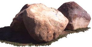
When our family moved into a new house in Algeciras, Spain, in the spring of 2001, I wasn’t expecting to discover anything significant which might relate to the biblical account of the Flood. We moved into a house on the highest hill within the city limits. For three years, I watched construction at numerous sites in an area that previously had almost no buildings. I noticed the builders were constantly digging up dozens of giant boulders (see photos). They hauled some away, others they broke into smaller pieces, and others they left here and there as a kind of decoration.
Why didn’t I see it?
One day I suddenly thought, ‘How did so many huge boulders get buried on the highest hill in town?’ The obvious answer got me immediately excited: Our neighbourhood is built on top of evidence for a huge geological catastrophe, likely during the final stages of the worldwide Flood told about in Genesis 6–9! Immediately, I began to investigate the geology of the area surrounding Gibraltar, aided by suggestions from a geologist friend, Guy Leduc.

The region around Gibraltar has many different kinds of geological formations, including the Rock of Gibraltar itself. Consisting primarily of a sedimentary rock called limestone, it is said to be of Jurassic age.1,2 There are lots of fossils, mostly broken in pieces, apparently having been deposited in swift moving water currents.3
The mountains surrounding Gibraltar are up to 830m (2,720ft) high and are made of thick, clearly defined layers of sandstone, called flysch. These are dated older than Gibraltar, at Triassic age.4,5 Another area at the southern end of Algeciras, called Los Pastores, consists of fossil-bearing limestone, sandstone and a mixture of clay and limestone called marl.6 These rocks are dated in between the other rocks, from upper Triassic to the lower Jurassic.7
The hill in Algeciras with the boulders, called Las Palomas on one side and La Granja on the other, is made up of loosely packed soil, which caused tremendous problems for the builders. The soil shifted so much under one large apartment building that it began to split in two!
There are hundreds of boulders scattered throughout this loose soil, perhaps even thousands if they could all be exposed. The hill rises 104m (340ft) above sea level8 and some of the boulders excavated at the very top of the hill were more than 2.5m (8ft) long! I estimated that the largest boulder weighed 12 tonnes.
How did they get there?
What could have possibly pushed so many huge boulders up 90m (300ft) above the surrounding plain? Gibraltar is far below the southernmost line of ice cover during the Ice Age. Although much earth movement took place prior to the formation of this hill, its age,9 composition, shape and location10 seem to rule out significant uplift.
Furthermore, there is a hill to the northwest with nearly identical characteristics with this hill, except that there are no visible strata in the rocks beneath. These two hills, along with several similar, though smaller, ones in the area, lie at the southeastern end of a long valley which acted as a channel for the mud and boulder-filled flow that formed these hills.
After examining all of the data, I conclude that an extremely deep mud and boulder-filled gush of water, over 90m (300ft) high and travelling at enormous speed, came rushing down the valley and formed these hills in a matter of hours or days at the most. Where did all this sediment laden water come from? Since we did not see it, we can only speculate. However, a perfectly plausible explanation would be tsunami-like waves rushing back to the sea toward the end of the worldwide Flood spoken of in Genesis. Combined with the fossil evidence mentioned above, this means that the whole region was formed recently and in a relatively short time.
References and notes
- The standard geological column has the Jurassic age from 140 to 205 million years ago. However, Jurassic rocks were generally deposited as the waters of Noah’s Flood (about 4,500 years ago) were approaching their highest level on the earth. Return to text.
- Rose, E.P. and Rosenbaum, M.S., A Field Guide to the Geology of Gibraltar, Gibraltar Heritage Trust, Gibraltar, p. 36, 1991. Return to text.
- Ref. 2, pp. 43, 46. Return to text.
- Triassic rocks are said to range from 205 to 245 million years ago, but in reality were deposited slightly earlier in Noah’s Flood than the Jurassic ones (see ref. 1). Return to text.
- López, F.J., Itinerarios naturalistas del Campo de Gibraltar, Mancomunidad de Municipios del Campo de Gibraltar, Algeciras, Spain, pp. 22, 181, 2000. Return to text.
- Marl is a mixture of clay and fine-grained limestone. Return to text.
- Valenzuela, J.M., El afloramiento paleontológico de ‘los Pastores’ Algeciras, Instituto de Estudios Campogibraltareños, Algeciras, Spain, p. 26, 1993. Return to text.
- Urban planning map, Ayuntamiento de Algeciras, 1998. Return to text.
- Chamorro, S. and Nieto, M., Síntesis geológica de Ceuta, Ayuntamiento de Ceuta, Ceuta, Spain, p. 7, 1989. Return to text.
- Specifically, the hill consists of loosely packed soil without stratification. It has a crescent shape (with a gentle convex incline, and a sharp concave decline) and is located at the mouth of a valley on an alluvial plain. Return to text.
Readers’ comments
Comments are automatically closed 14 days after publication.