
Geological excursion at Giant’s Causeway in Northern Ireland
A giant first—interpreting an iconic World Heritage Site using biblical history

In September 2014, I visited the Giant’s Causeway in Northern Ireland to conduct two geological tours on the same day. In all almost 90 enthusiasts came from all over the province, and some from Republic of Ireland, even as far south as Dublin and Athlone. The event was organized by CMI-UK/Europe in partnership with Creation Outreach Ministries of Northern Ireland.
The aim of the tours was to train people to see how the Bible explains the rocks and landscapes. We wanted people to understand how this worked, and not just take our word for it, so we made a point of discussing what we could actually see as we walked along the various paths (figure 1). Then we would explore ideas about what could have happened in the past, events that would explain the features in the present, including explanations by long-age geologists. We were careful to stress that stories about what happened in the past are speculative because we cannot go back in time and make observations. However, the approach taken for biblical geology is different from that of long-age geology. It has a logically defensible basis because it does have observations of past events—observations made by those who were present at the time, which have been written down and passed onto us in the biblical account.
For each tour we hiked some 3 km (2 miles) along walking paths, inspecting the rocks and landscapes, and occasionally climbing some very steep slopes. The excursions lasted about three hours each, and we had warned participants to bring appropriate outdoor clothing in case of rain and strong winds. However, on the day, we were greeted with glorious sunshine, blue skies, and a calm ocean—an Indian Summer. Many said they could not remember a better day.
The organizers had booked a function room in the Giant’s Causeway Hotel, where people gathered to be briefed. Each person was given an excursion guide (see box) together with a little radio receiver to hear my commentary without needing to crowd in close. The organisers had obtained 50 such receivers, which were similar to those which National Trust guides use on their tours.
Those taking part came from a wide geological background, some with very little knowledge and a few who were professional geologists. On the tour we covered much basic geology, beginning with the decorative basalt columns on the outside of the new Visitors’ Centre.1 Here we studied the mineral structure of the basalt, explained the different types of magma (molten rock), how magma moves through the crust of the Earth, erupts onto the surface, and crystallizes.
From the Visitors’ Centre we walked 1 km (0.6 miles) down the bitumen path to the Causeway itself, weaving our way through the multitude of sightseers, being careful to avoid the busses shuttling people up and down. Apart from the beautiful scenery, there are many interesting features to look at.
In the rocky headlands jutting into the sea we could see the dark, horizontal basalt beds, called the Lower Basalts. A broken ‘wall’ or sea stack stands in the small bay near the shore, looking from the side like a camel, which is why it has been called The Camel’s Back. It’s the remains of a dike, formed when the earth moved and split the Causeway rocks, allowing molten lava to rise into the crack and solidify into a ‘wall’. There are many dikes visible along the coast.
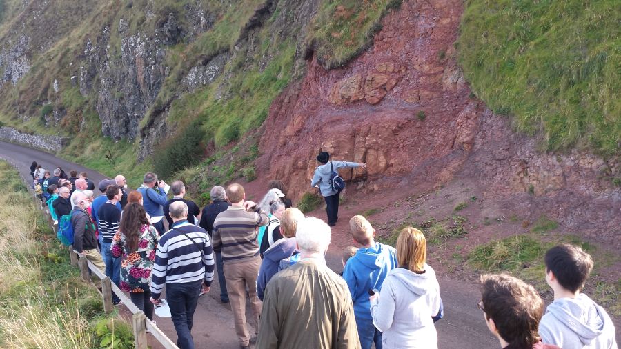
The path ran alongside the cliff which towered overhead, and rose steeply to the Antrim Plateau. In the escarpment we could make out more flat-lying basalt beds, in this case called the Causeway Basalts. Immediately alongside the path, not far from the Visitors’ Centre, is a mass of soft, red, crumbly material that catches the eye (figure 2). This 10–12 metre (35–40 feet) thick bed is called the Interbasaltic Bed, because it sits between the Lower Basalts and the Causeway Basalts. As you follow the path you can see that this red bed dips downhill. It’s claimed to be an ancient soil that formed slowly over millions of years, which is why it’s called a laterite. This time-frame contradicts the history of the Bible, and not surprisingly we saw many characteristics of this bed that do not fit the ‘ancient soil’ explanation, which we will discuss later.
Halfway down, the path turns through Windy Gap, where you can see outcrops of the black Lower Basalts alongside. The basalt rock has been disintegrating to form rounded, spherical boulders that are sitting in a soft, brown, crumbly ‘soil’. The weathering forms a soft skin on the boulders, a process that is sometimes called onion-skin weathering. As you round the corner you have a clear view of the Causeway jutting into the ocean like the tail of a crocodile.

Even though the view at the Causeway is incredibly spectacular, with massive cliffs and expansive landscape, there is not a great variety of geology exposed. It mostly consists of large flows of basalt lava. To provide a better perspective for the sorts of rocks that are found on the Causeway Coast, I included a geological cross section in the excursion guide that covered some 25 km (15 miles) along the coast. This section (figure 3) shows how far the lower basalts extended along the coast and how they are related to other rocks that we could not see at the Causeway itself. For example, the geological cross section shows that the Lower Basalts sit on a thick deposit of chalk, not visible at the Causeway. In addition, there are many faults in the section indicating that the land has been broken in the past, and that different parts of the coast had moved up and down relative to each other. The section also shows how the land surface had been eroded reasonably flat to form the Antrim Plateau. This cross section gives a broader perspective to the order of the geological processes that occurred in the past, and how they formed the landscape.

One of the fascinations of the Causeway is the way the rocks on the headland sit tightly together in a honeycomb pattern, like paving stones. It might almost look as if it was constructed by human hands. Most stones have six sides, but they can vary from four to seven. Advertising blurbs say there are 40,000 columns, but it is hard to imagine how someone would have counted them all. The Causeway itself provides amazing examples of the columns, but there are other spectacular exhibits further on, including The Organ which sits alongside the path some 500 m (550 yards) beyond the Causeway.
On top of the vertical columns in each flow sits a chaotic mass of irregular, fractured basalt. Geologists have looked to Greek Architecture to name these features, calling the columns “the colonnade”, and the irregular mass “the entablature”, which resembles a lintel. You can see outcrops of different entablatures at various levels up the cliff, with The Organ being the most prominent. In the past, large chunks of entablature rocks have broken off and rolled down to the bottom of the cliff (figure 4).
Together the colonnade and entablature represent a single lava flow. So when you are standing alongside The Organ, for example, and see how far the columns tower above you, and then note the height of the top of the entablature above that (figure 5), you can imagine how much molten lava had accumulated, and how it would have moved across the ground surface like a fiery ocean, belching ash and toxic gases into the sky. And the molten lava had to move quickly to fill the whole area before it cooled, solidified, and stopped flowing.
Participants learned that the remarkable shapes of the columns formed after the lava crystallized. Once the huge volume of lava had accumulated, and began to cool and solidify into rock, further cooling caused contraction, creating stress. Little star-shaped cracks developed in the rock. With more cooling these cracks grew larger until their points joined together, forming polygons with four to seven sides. At the top of the lava flow, where cooling was rapid because of the presence of water, the cracks grew rapidly and randomly, forming a chaotic mass. Further down, where the cooling was slower, the cracks grew in an orderly fashion, moving downward, forming vertical columns. After the columns were complete, they continued to cool and contract, causing them to break into long pieces with ‘ball and socket’ joints.
After we had explored the Causeway (figure 6), we set out for the next rocky headland, which involved a long walk up some steep inclines. Since the remaining route included a steep climb, a few people decided to end their tour and took the shuttle back to the Visitors’ Centre. But other people who had encountered the tour and overheard the commentary asked if they could join, and they were able to use the spare radio receivers.

We followed the path as far as the rocky headland adjacent to Port Reostan and had a great view of The Organ, the Interbasaltic Bed, vertical dikes in the ocean, and a basalt flow with curved columns, called The Harp. We returned by climbing the escarpment via the steep Shepherd’s Path, which culminated in more than 150 steps. It was with a sense of achievement that we reached the top of Antrim Plateau, and paused to catch our breath. As we walked back to the Visitors’ Centre we had a good view of the rolling surface of the plateau and could appreciate how it had been eroded flat, first by receding floodwaters and then by glaciers that covered the landscape during the post-Flood Ice Age. (See box: The Bible explains the Ice Age.)
Along the way we discussed different geological explanations. Many ideas that had been proposed by long-age geologists seemed to make good sense, especially interpretations that recognized geological catastrophe and the presence of large amounts of water. The geological evidence thus described was consistent with the catastrophic processes operating during Noah’s Flood. However, some of the long-age stories conflicted with the biblical timescale, and this identified a problem that needed investigation, and highlighted the need for some different scenarios.

In this regard, one feature significant for the biblical interpretation is the prominent, red, Interbasaltic Bed. This is visible alongside the path near the Visitors’ Centre, and on the far side of the Causeway near the headland at Port Reostan. Long-age geologists say this bed is an ancient soil formed by tropical weathering over millions of years, a story that conflicts with the biblical age for the Earth. We spent some time examining the bed close up, and could see there were geological problems with that story. We discussed different scenarios for its formation, including the idea that heat and fluids released from within the molten lava itself caused its alteration soon after it was emplaced, a process that would happen quickly. This scenario would also explain a similar red horizon visible at sea level in the distant headland between two flows of the Lower Basalts, a horizon that was much thinner than the Interbasaltic Bed. (See Reading between the Giant’s Causeway basalts and Giant’s Causeway geology clarified for Earth Science Ireland.)
During the excursion we discussed issues related to the timing of the formation of the Causeway, such as its emplacement and erosion. The underlying chalk deposits (figure 3) were significant for addressing this question, as well as the relationship between the different kinds of rocks, and the shape of the landscape. We concluded that the Causeway was emplaced after the chalk layers were deposited, as the waters of the Flood were receding into the ocean. Further, the area was eroded first by the receding floodwaters and then by glacial ice during the post-Flood Ice Age. (See: How did the Causeway form?)
Excursion Guide
Participants received a complimentary geological field excursion guide entitled “Fire, Flood and Catastrophe”. This included maps and information about the Causeway and the adjacent coast (compiled from readily available sources), together with material to understand the geology of the region and interpret it from a biblical perspective. A pdf of the guide can be downloaded here. Print it double-sided landscape on A4, and staple in the middle.
All in all, as the unsolicited feedback from many participants confirms, it was a fantastically enjoyable field trip. One enthusiastic participant said, "I used to just come here and appreciate the beauty of the rocks, but now I can appreciate them in a much more satisfying way connecting them to biblical history and my faith." Indeed, those who took part received a broad experience of geology and learned about different views of looking at the world. This contrasts with presentations by conventional geological publications, which only present one interpretation—their long age one—and openly lobby to censor any other ideas from the public square. But why should only one view be presented on an important issue when it is subjective speculation? It’s only fair for people to be properly educated about the various ideas on offer and given opportunity to think about and decide these issues for themselves. In this regard, it was pleasing to see that the Visitors’ Centre has one small audio that mentions the debate over the age of the Causeway, remarking that it is ongoing and that some people today do not accept the claimed age of 60 million years. (See How dating methods work and The way it really is: little-known facts about radiometric dating.)
It’s possible that one day, the guides at the Visitors’ Centre will make a point of separating the actual evidence at the Giant’s Causeway from the speculative stories. Perhaps one day tourists will be informed that the rocky outcrops are a memorial of the vast watery catastrophe that overtook our globe just some 4,500 years ago. When we understand what really happened in the past, it places our lives within a wholly different perspective. The world looks wholly different, our place in it is clearer, and our destiny comes into focus. May the tiny audio at the Giant’s Causeway interpretive centre grow into something more inclusive and more enlightening for the benefit of all who visit this World Heritage site.
The Bible explains the Ice Age
After its eruption, Giant’s Causeway was overtaken by glacial ice which eroded the cliffs to shape this World Heritage Site. Today, some 10% of the earth’s land surface is covered with ice sheets and glaciers, but there was much more ice cover in the past. The evidence for greater ice includes U-shaped valleys cut by glaciers, mounds called drumlins pushed up by glaciers, rocks that are scoured and scratched, broken rock, called tillite, pushed by glaciers into mounds called moraines, and erratic boulders dropped by floating ice into sediment.
Ideas that long-age scientists have proposed include large meteorite impacts, supervolcano eruptions, and changes in things such as atmospheric carbon dioxide, the sun’s solar output and the orbit of the Moon. The most popular idea today relies on Milankovitch cycles, where changes in the tilt of the earth’s axis and in its orbit around the Sun make the climate cooler every 41,000 years or so.
One problem with all these ideas is that the proposed effects are too small; they do not cause a large enough change in the temperature. So, it is further proposed there must be a positive feedback mechanism that amplifies the change. The possibility of positive feedback has made today’s climate scientists worried that a small change in climate may cause a large instability.
Another problem is that a cooler earth will not cause ice to build up on the continents. It will just create a cold desert, like most of northern Siberia and Antarctica today. For ice to build up, we need increased precipitation of snow and ice.
Biblical geology provides an obvious and simple explanation for the start and end of the Ice Age.2
The evidence for the Pleistocene Ice Age indicates it was very late geologically, which means it occurred after the global Flood. The Flood is the key. Being a catastrophic, tectonic event, much volcanism occurred and this heated the oceans to warmer than they are today. Indeed, ice cores show evidence of warmer oceans in the past, which we place immediately after the Flood. This evaporated the water needed for the ice accumulation; the warm oceans increased evaporation which precipitated as snow and ice on the continents.
Also, after the Flood, there would have been fine volcanic dust high in the atmosphere, which kept the interiors of the continents cooler in summer. The snow and ice that fell on the continents in winter was not fully melted the following summer, so the ice built up from year to year. Oard estimates that the ice accumulated for 500 years. After the oceans cooled and the volcanic dust cleared, it would have taken some 200 years for the ice to retreat to where it is today. Thus, when the Flood ended, the conditions were exactly as needed to create the Ice Age.
References and notes
- The new Visitors’ Centre opened in 2012 and cost £18.5 million. One of the displays has a 20 second audio commenting that creationists today have a different perspective on the age of the Earth from that of mainstream scientists. New visitors’ centre opens at Giant’s Causeway, Northern Ireland. Return to text.
- Oard, M.J., An Ice Age Caused by the Genesis Flood, Technical Monograph, Institute for Creation Research, El Cajon, CA, pp. 135–149, 1990. Return to text.


Readers’ comments
Comments are automatically closed 14 days after publication.