

Massive erosion of continents demonstrates Flood runoff

Massive amounts of sediments, many kilometres thick, with buried plants and animals, were laid down early in the Great Biblical Flood (often called Noah’s Flood). These were cemented into sedimentary rock and the organisms were fossilized. Then the mountains and continents rose up and the valleys and ocean basins sank (Psalm 104:6–9). This caused the Flood water to rush off the continents, sometimes at high speed. This is called the Recessive Stage of the Flood,1 and probably started about Day 150, nearly midway into the Flood. It would have resulted in enormous erosion of vast areas of the continents.2 The results of this erosion are clearly visible in every landscape around the world..
Estimating continental erosion
There are several ways we could try to estimate the amount of this erosion in any area, but there are four methods that are the most direct and involve the fewest assumptions. The first involves the height of erosional remnants, such as Devils Tower (figure 1), northeast Wyoming, USA.3 These are parts of original rock left standing after all the surrounding rock has been eroded. The difference between the top and bottom of the erosional remnant gives a minimum estimate of the amount of erosion in the area. Based on this method, over 350 metres (1,200 feet) of erosion occurred around Devils Tower.

A second method is to determine the amount of erosion in the center of a huge uplifted dome of sedimentary rock (figure 2). By extrapolating where the tilted sedimentary layers used to extend over the dome, the amount of erosion can be estimated.
A third method considers the rank of coal at or near the surface. The formation of coal is mainly related to temperature, with rank increasing with higher temperature from lignite, to bituminous, to anthracite coal. Since temperature is proportional to the depth of burial of plants, higher rank coals suggest deeper burial and thus, greater erosion for the coal to subsequently be at the earth’s surface. Other factors can complicate the calculation, but coal rank does provide an educated guess. Bituminous or anthracite coal at or near the surface typically suggests prior burial under around 3,000 to 6,000 metres (10,000 to 20,000 feet) of overburden.
A fourth method of determining erosion on a regional scale is to estimate the volume of sedimentary rocks in the continental margin, which includes the continental shelf, slope, and rise. If the drainage area for these sedimentary rocks can be estimated, a rough estimate of total erosion can be made.
Enormous continental erosion
Unless there is coal at the surface, we cannot estimate the erosion at many places of the world, such as the Great Plains in the middle of the United States, because the terrain is so flat. We know that mountainous areas were tremendously eroded of capping sedimentary rocks during their uplift, but we can only rarely make estimates. But there are many other places where we can make a direct estimate of the minimum erosion, and it is truly enormous.
The thick sedimentary rocks of the Colorado Plateau in the southwest United States that cover 337,000 square kilometres (130,000 square miles) are only mildly deformed into domes and basins. The domes have been heavily eroded. Using the second method above, we can measure the dip (downward tilt) of the sedimentary rocks along the edge of eroded domes and calculate the erosion over the dome. In this way we see that the average amount of erosion of the Colorado Plateau is 2,500 to 5,000 metres (8,000 to 16,000 feet)—over the whole area!4
The Appalachian Mountains of the eastern United States are rounded, indicating much erosion. The amount of erosion can be estimated from the rank of coal at the surface and the amount of sedimentary rocks offshore.5 Both methods give the amount of erosion at about 6,000 metres (20,000 feet).
The scientific literature gives many more estimates of erosion. Other areas of North America demonstrate similarly significant erosion. More than 1,600 metres (5,000 feet) of rock was eroded from southern Arizona.6 Several thousand metres of strata disappeared from the Rocky Mountains, foothills, and western Plains of southern Canada.7

Figure 3. Uplifted, eroded Wealden Dome of southeast England. Total erosion in the center of the dome is about 1,500 m.
Geological features in Australia show that this continent was also heavily eroded.8 For example, probably 6,000 metres (20,000 feet) of rock was removed from the Flinders Ranges in South Australia.9 In Europe, about 3,000 metres (10,000 feet) has been removed from the eroded mountainous areas of Wales in the United Kingdom.10 About 1,000 to 1,600 metres (3,000 to 5,000 feet) of sedimentary rock was stripped from southeast England (figure 3).11
Partridge believes more than 1,000 to 3,000 metres (3,000 to 10,000 feet) of rock was eroded from southern Africa.12 More impressive is the 4,000 to 7,000 metres (13,000 to 23,000 feet) of erosion that occurred along the coast of the 260 km-(160 mile-) long McMurdo sector of the Transantarctic Mountains of Antarctica.13
Valley and basin erosion
Late in the Recessive Stage of the Flood, the currents became more channelized as more and more mountain ranges and plateaus became exposed above the Flood water. It was at this time that valleys and deep canyons were eroded. We can use the same methods above to provide good estimates of the minimum amount of erosion in valleys and basins that have thick sedimentary rocks. For examples, the valleys and basins of the Rocky Mountains of the United States contain thousands of metres of sedimentary rock, but the top has been eroded off. Based on erosional remnants and eroded domes, the first two methods above, geologists have determined the minimum amount of erosion.14 Average estimates of basin erosion are around 850 metres (3,000 feet) in Wyoming, 1,520 metres (5,000 feet) in Colorado, and up to 1,000 metres (3,000 feet) in New Mexico.
As an example, the Bighorn Basin of north-central Wyoming is about 21,000 square kilometers (8,000 square miles). It has 4,500 to 7,500 metres (15,000 to 25,000 feet) of sedimentary rocks. Tatman Mountain (figure 4) in the center of the Bighorn Basin is 1,899 metres (6,230 feet) above sea level and is an erosional remnant of basin erosion. It has a flat top and represents a planation surface15 with rounded rocks on top from the action of water. Based on the height of Tatman Mountain and the eastward slope of the Bighorn Basin, the amount of erosion ranges from about 350 metres (1,000 feet) in the west to 750 metres (2,500 feet) in the east. The amount of eroded sedimentary rock is about 10,000 cubic kilometres (2,000 cubic miles) and is not found downslope to the east, as expected if erosion were slow over millions of years. The eroded debris has been swept clean off the continent and now forms part of the thick sedimentary rocks along the margin of the Gulf of Mexico.

Erosion was rapid
There are other indications that continental erosion was rapid and not slow over millions of years, as believed by secular scientists. For instance, Devils Tower would not remain standing for millions of years while all the surrounding plains were eroded.3 The same can be said for any of the thousands of tall erosional remnants across the earth. Erosion of vertical faces is much faster than horizontal surfaces because numerous rock slides and rock falls occur on steep slopes.16 Furthermore, the extensive vertical cracks of the Devils Tower would be prone to destruction by freeze-thaw weathering. Cracks fill with water during storms, and as the water freezes during cold periods, the ice expands and enlarges the cracks. We would expect blocks of rock to frequently break free and fall to the base of the tower each winter. And indeed that is what is observed today:
“While living near the base of the Tower in November 1954, during periods of frost action at night one could hear blocks crash onto the talus [the rock debris at the base]. This would happen typically after a snowfall … On a warm sunny day the snow would melt and the moisture would enter the joints [vertical cracks] in the Tower. After dark, the water would freeze and expand, which over time continues to force blocks from the Tower and build more talus.”17
Devils Tower should have been destroyed quickly within a timeframe of tens of thousands of years, certainly in less than 100,000 years, and yet it is claimed to have existed for millions of years. Devils Tower and other erosional remnants can be explained by the Genesis Flood that eroded all the sedimentary rock around but for various reasons left Devils Tower. Likely the volcanic rock (phonolite) of Devils Tower was harder than the surrounding sedimentary rock.
Strong evidence for the Genesis Flood
The evidence of rapid, enormous erosion all over the earth (erosional remnants are worldwide) is what is expected during the Recessive Stage of the global Genesis Flood. It is known that large floods leave behind erosional remnants, such as occurred in the Lake Missoula flood in the northwest United States at the peak of the Ice Age.18 Steamboat Rock in the upper Grand Coulee of central Washington State, USA, (figure 5) is a 275-metre (900-foot) butte of basalt lava that was left as an erosional remnant.
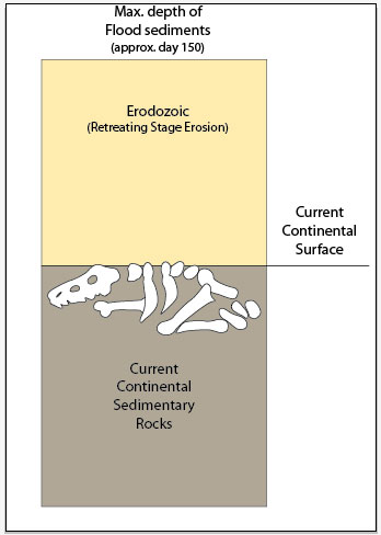
All this erosion indicates that considerably more sedimentary rock and sediments were on the continents at the peak of the Flood (figure 6). The rocks exposed at or near the surface of the continent are what is left over after the rapid erosion during the Recessive Stage of the Flood.
Once we understand the enormity of the cataclysm unleashed on the earth through Noah’s Flood, the landscapes of the world take on a new significance. Noah is commended in this way: “By faith Noah, when warned about things not yet seen, in holy fear built an ark to save his family” (Hebrews 11:7).
References and notes
- Walker, T., A biblical geologic model; in; Walsh, R.E. (Ed.), Proceedings of the Third International Conference on Creationism, technical symposium sessions, Creation Science Fellowship, Pittsburgh, Pennsylvania, pp. 581–592, 1994. Return to text.
- Oard, M.J., Continental erosion places the Flood/post-Flood boundary in the late Cenozoic, J. Creation 27(2):62–70, 2013. Return to text.
- Oard, M.J., Devils Tower can be explained by floodwater runoff, J. Creation 23(2):124–127, 2009; creation.com/landscape-erosion. See also Walker, T., Devils Tower and Bible glasses, Creation 24(3):20–23, 2002; creation.com/devils_tower. Return to text.
- Schmidt, K.-H., The significance of scarp retreat for Cenozoic landform evolution on the Colorado Plateau, U.S.A., Earth Surface Processes and Landforms 14(2):93–105, 1989. Return to text.
- Oard, M.J., Origin of Appalachian Geomorphology Part I: erosion by retreating Floodwater, Creation Research Society Quarterly 48(1):33–48, 2011. Return to text.
- Oard, M.J. and Klevberg, P., Deposits remaining from the Genesis Flood: Rim Gravels in Arizona, Creation Research Society Quarterly 42(1):1–17, 2005. Return to text.
- Bustin, R.M., Organic maturity in the western Canada sedimentary basin, International Journal of Coal Geology 19:319–358, 1991; Osborn, G., Stockmal, G. and Haspel, R., Emergence of the Canadian Rockies and adjacent plains: a comparison of physiography between end-of-Laramide time and the present day, Geomorphology 75:450–477, 2006. Return to text.
- Galloway, R.W., Introduction; in: Davies, J.L. and Williams, M.A.J. (Eds.), Landform Evolution in Australasia, Australian National University Press, Canberra, Australia, pp. 1–4, 1978. Return to text.
- Twidale, C.R. and Campbell, E.M., Australian Landforms: Understanding a Low, Flat, Arid and Old Landscape, Rosenberg Publishing Pty Ltd, Dural Delivery Centre, New South Wales, Australia, p. 195, 2005. Return to text.
- Small, R.J., The Study of Landforms: A Textbook of Geomorphology, second edition, Cambridge University Press, London, U.K., p. 266, 1978. Return to text.
- Jones, D.K.C., On the uplift and denudation of the Weald; in: Smith, B.J., Whalley, W.B. and Warke, P.A. (Eds.), Uplift, Erosion and Stability: Perspectives on Long-Term Landscape Development, Geological Society of London Special Publication No. 162, The Geological Society, London, U.K., p. 32, 1999. Return to text.
- Partridge, T.C., Of diamonds, dinosaurs and diastrophism: 150 million years of landscape evolution in Southern Africa, African Journal of Geology 101(3):167–184, 1998. Return to text.
- Sugden, D. and Denton, G., Cenozoic landscape evolution of the Convoy Range of Mackay Glacier area, Transantarctic Mountains: onshore to offshore synthesis, GSA Bulletin 116(7/8):840–857, 2004. Return to text.
- McMillan, M.E., Heller, P.L. and Wing, S.L., History and causes of post-Laramide relief in the Rocky Mountain orogenic plateau, GSA Bulletin 118(3/4):393–405, 2006. Return to text.
- Oard, M., It’s plain to see: flat land surfaces are strong evidence for the Genesis Flood, Creation 28(2):34–37, 2006; creation.com/plain. Return to text.
- Twidale, C.R., Geomorphology, Thomas Nelson, Melbourne, Australia, pp. 164–165, 1968; Pazzaglia, F.J., Landscape evolution models; in: Gillespie, A.R., Porter, S.C. and Atwater, B.F. (Eds.), The Quaternary Period in the United States, Elsevier, New York, NY, p. 249, 2004. Return to text.
- Robinson, C.S. and Davis, R.E., Geology of Devils Tower, Wyoming, Devils Tower Natural History Association, p. 36, 1995. Return to text.
- Oard, M.J., The Missoula Flood Controversy and the Genesis Flood, Creation Research Society Monograph Books, Chino Valley, AZ, 2004. Return to text.


Readers’ comments
Comments are automatically closed 14 days after publication.