

Journal of Creation 35(2):123–127, August 2021
Browse our latest digital issue Subscribe
Delta formation in the Kaystros estuary and silting of the Ephesus Harbour within biblical history
This paper highlights research relating to the history of the Kaystros estuary and Ephesus harbour as a 30-metre-deep estuary silted up through several thousand years of recorded history. While secular science extends the period of human settlement to 3000 to 5000 BC, the rate of sedimentation at the earliest times fits better within the biblical timeframe. Human activity likely speeded up rates of sedimentation due to the agricultural requirements of a growing population causing faster soil erosion. But the discontinuity in the secular timeframe is considered excessive, i.e. between the Classical-Hellenistic period and that of previous generations. It is considered likely that carbon-14 was not in equilibrium between the atmosphere and ocean towards the end of the Ice Age, which renders carbon-dating erroneous at the earliest time with a widening margin of error.
As sea levels rose at the end of the Ice Age previously extended river valleys were flooded, forming dendritic estuaries known as ‘rias’. Many of these rias subsequently silted up within recorded history. Examples exist from across the world of delta formation: the Rhine and Rhône rivers in Europe, the Ebro river in Spain, the Egyptian Nile, and the Mississippi in the Gulf of Mexico. The geomorphology of delta formation is dependent upon a number of factors, such as relative water density, river flow rates, offshore currents, tidal range, and wave energy. This paper will focus upon the Cayster or Kaystros (Ancient Greek: Κάϋστρος / Turkish: Küçük Menderes) river estuary at ancient Ephesus, located on the coast of western Turkey, much of which silted up within recorded history. Figure 1 shows the location.

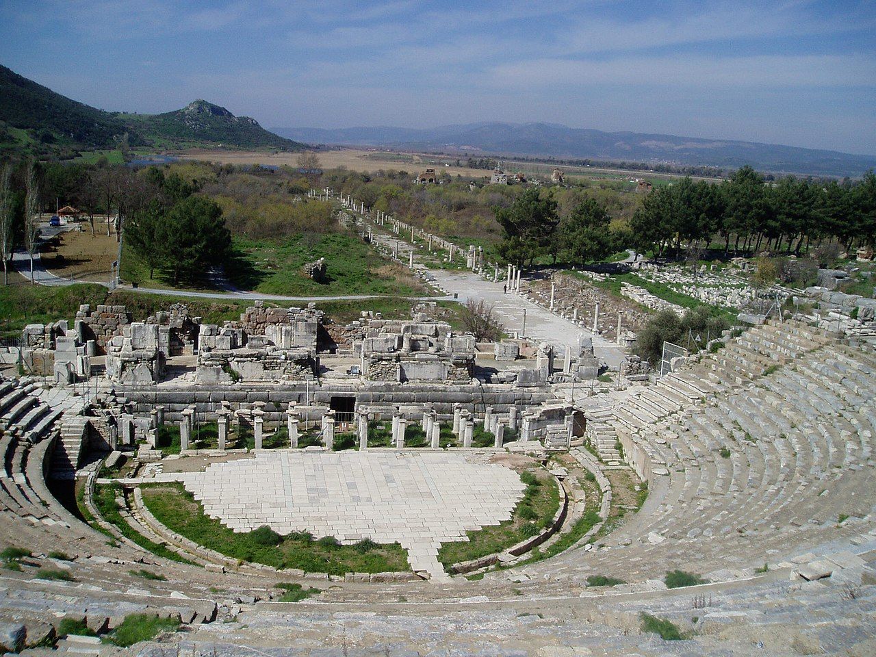
The ancient city of Ephesus is well known to Christians from the New Testament. Paul preached there during his ministry (Acts 19), and saw miracles and revival. This was followed by rioting, led by adherents of the goddess Artemis, who were concerned about loss of revenue from the trade in idols. During this time there was a harbour at Ephesus, and the city was the Roman capital in Asia Minor in the time of Augustus (figure 2). But the harbour was slowly silting up. In fact, the harbour and estuary of the Kaystros river had been silting up for many centuries prior to this, and this continued through the Roman and Christian eras. Today the harbour and city that Paul knew are several kilometres inland from the coast (figure 3).

It is evident that coastal margins have changed markedly since the end of the Ice Age, and within the timeframe of human history. Much of this is recorded in written sources, understood through archaeology and examination of the geomorphology. This discussion will highlight ongoing secular research, and show that deposition has occurred within recorded history over centuries, and can be fitted within a biblical timeframe. This points to relatively recent adjustments to the landscape following the Flood and Ice Age epochs.
At the peak of the post-Flood Ice Age, with millions of cubic kilometres of water locked up in ice, sea levels were an estimated 50 m below current levels,1 and then rose to near current levels as the ice melted. Once the sea level had risen and flooded valleys at the end of the Ice Age, the process of sedimentation began in newly formed rias, or marine gulfs. Delta formation in this valley may be classified as a freshwater tidal delta, where the river water meets the sea and dendritic-shaped sub-estuaries are formed.2 Fresh water washes material downstream and deposits it where the tidal ebb-and-flow meets the river flow. The twice-daily tidal hiatus of the river flow causes deposition of suspended material within the estuary, as do periodic river floods. The natural process of deposition of sediment in the flood plain is often accelerated by human activity: e.g. forest clearance for agriculture by a growing population increased the rate of land erosion, and sediment load in the river. This increase in population occurred after the post-Babel communities had spread out and settled in the virgin land.
Historical sketch of settlement at Ephesus

The first human settlers in this area are described as Neolithic and believed to have arrived in the valley around 5000 to 3000 BC by secular science. The Neolithic people are said to have developed settled farming practices through animal rearing and crop plantations, but had not yet developed the skills of metallurgy, which is identified as the later Bronze Age, Iron Age, etc. However, the division of history in this way is really built on the secular myth of an evolutionary progression and departs from biblical history.
During the second millennium bc the Arzawa kingdom had located its capital at Apasa (Ephesus), later settled by Mycenaean expansion around 1300 BC.3 The Archaic Greek or Ionic period can be traced from about the 10th to the 6th century bc. The first temple of Artemis (Artemision) was attributed to the semi-mythical Amazons by the Greek poet Callimachus in the Hymn of Artemis, although a site of worship probably existed here prior to Greek arrival. This temple, built near the water’s edge, was destroyed by a flood in the 7th century BC, and rebuilt by Croesus, the Lydian king around 550 BC following conquest of the city. The location of the temple was to the north-east of Mount Pion (figures 1 and 2). It was later destroyed by fire in 356 BC, and rebuilt again from 323 BC. The Classical Greek period continued from 500 to 350 BC, the Hellenistic period from 350 BC, and the Roman period from around 129 BC. The Byzantine period ran from 395 to AD 1308, followed by the Ottoman era. Archaeological work in the 20th century found the Artemision and access roads covered by 5 or 6 m of alluvial and colluvial material (figure 4).
During the Hellenistic period, the city and harbour were sequentially moved downstream, for example by Lysimachus around 290 BC, with progradation of the estuary. But even the new harbour became difficult to navigate. The Roman historian Titus Livius (63 BC to AD 17) recorded that the harbour entrance at Ephesus in 190 BC was “like a river: long and narrow and full of shoals”.4 Attempts to stop this process of sediment accumulation may have had adverse consequences. Strabo (64 BC to AD 23) noted the further narrowing of the entrance with the establishment of a mōlēs, an estuary embankment that separated the river from the harbour, and hindered the “ebb and flow of the tides”.5
Geomorphology of the Kaystros estuary
The geomorphology, particularly the sedimentary features of the Kaystros valley, has been changing over several millennia, and examined over recent decades through the utilization of core samples, archaeology, and ancient texts, and described in several papers.6-8 The valley, in which ancient Ephesus resides, is a graben, known today as the Küçük Menderes graben. The implication is that the valley has been displaced vertically downwards along faults that run parallel with the valley. This region suffers from damaging earthquakes as a result of numerous faults in the region. Such local isostatic changes to the sea level may be several metres over the past few thousand years, with eustatic changes around 1–2 m at the most. Kraft et al. suggest a lowering of sea levels of up to 2 m between 1000 and 1500 BC, followed by a steady rise to today’s level.6,8 The surrounding hills are horsts, having been displaced vertically upwards.
The Menderes mountain range in this area is formed of hard crystalline metamorphic rocks—identified as Palaeozoic and Lower Mesozoic by secular science—typically gneiss and granite-mica schist, and phyllite, quartzite, and marble. Along with this are Miocene–Neogene softer deposits of marly limestone, sandstone, and clays.6,8 With uplift and erosion during the late Neogene/Quaternary, re-interpreted here as the recessional period of the Flood, and with excessive rainfall in the immediate post-Flood and Ice Age period, massive denudation and modification to the landform occurred. At the peak of the Ice Age the lower valley floor was some 30 m deeper than today’s level, with the seashore extended westwards and some 50 m below current levels.
At the end of the Ice Age, following associated rises in sea level, the sea encroached some 18–20 km inland along the newly formed ria.7 The Kaystros valley narrows above Ephesus, and then opens out into a wider plain, part of which was then Lake Belevi—now it is a smaller, shallower marshy lake (figure 1). During the Ice Age this was a freshwater lake, then became brackish as sea water flooded the valley at the end of the Ice Age. As delta progradation began in the Kaystros valley, the lake became cutoff from the ocean and reverted to a freshwater lake once more, but continued to accumulate sediment. Stock et al. trace the start of lake sedimentation back to 8,000 years before present, with descriptions of two core samples from near the lake shore.9
Kraft et al. highlighted delta progradation along approximately 14 km of the valley, through an estimated period of about 5,000–7,000 years (figure 1).6,8 This is proposed from the Neolithic period, with substantial amounts of alluvial and colluvial deposits subsequently causing the estuary to silt up. Alluvial deposits have been brought down the valley along the river, and colluvial material by the action of gravity, earthquakes, rainfall, and other factors acting on the eroding of the hill sides. Human activity, involving forest clearances and tilling of the soil, may have increased the rate of erosion and deposition as the population grew. Rates of sedimentation are also dependent upon the hardness and consolidation of the bedrock.
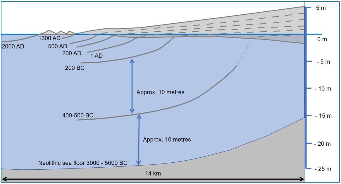
Kraft et al. estimated that sedimentation was accelerated in the Classical period (400–200 BC) as erosional use of the land increased, followed by a more gradual accumulation through the Roman and Byzantine period, and into the modern period. Their estimation is that an approximate 10 m depth of sediment accumulated between 3000 BC and 400 BC, and 10 m between 400 BC and 200 BC: an approximate ten-fold increase in the rate of deposition (a cross-section is shown in figure 5). However, estimates of population size and growth rates in ancient Greece are varied, with some studies suggesting that the population in this region grew more than ten-fold between 800 and 400 BC, along with colonization of the coastal regions of Asia Minor. But other estimates of growth rates are lower.10 This does however suggest the feasibility of faster rates of sedimentation prior to 400 BC, if population growth were faster. Through the several-thousand-year period of human settlement, the estuary, over 10 km in length, several km in width, and 30 m in depth, became completely filled in with sediment.6,8
The shape of the delta was evidently changeable through the period of progradation, which can itself affect rates of deposition.11 During the Hellenistic and early Roman period the Kaystros river deltaic sequences displayed typical ‘bird’s feet’ or dendritic distributaries, composed of sand and silt. Rates of sedimentation tend to be faster adjacent to the river channels. As delta progradation neared the open sea, sandy coastal barriers formed by the late Byzantine period. By this time, the harbour at Ephesus was no longer accessible.12 The river valley now displays typical meanders in the silted-up estuary, with cut-off, oxbow sections. The river was diverted into a canal towards the north of the flood plain in the 1930s, which, from satellite imagery, has evidently altered the shape of the beach with several hundred metres of new beach-front in about 90 years. Current rates of deposition have reduced because of water extraction, and coastal erosion has become a concern.12
With focus upon changes to the later Greek and Roman harbour at Ephesus, it can be seen that during the Roman period of Augustus there is evidence that the harbour went through a more rapid period of silting, and a period of anoxic conditions. The cause of this is not clear, but may be related to the construction of the harbour embankment. The rate is estimated at 20 cm/y, or 7 m over several decades, followed by a slower process until becoming dry in the early Middle Ages. The city of Ephesus was fed by a system of aqueducts that washed waste water into the harbour, but various earthquakes may have disrupted this water supply. This may have encouraged the build-up of sediment along with the formation of the embankment.7
Radiocarbon dating
Carbon radiometric dating has been correlated with archaeological and written sources by researchers at this location, where available. This helps with validation, as the presence of carbon-14 may be affected by contamination from a number of physical sources.13 More widely, a comparative correction is normally made to the raw data of samples or artefacts to account for changes in atmospheric carbon dioxide.14 This is based upon dendrochronology back to 9,000 years before present (BP), although dendrochronology is not without problems: for example, some tree species are known to show multiple growth rings per year,15,16 or the chronologies are artificially extended through weakly attached crossmatching ‘bridges’.17 At the longer time frame to 25,000 BP correlation utilizes sequences of corals, along with calibration with U/Th dating.18
Errors in marine dating are also not easy to iron out. The uptake of carbon in marine organisms, in terms of calcium carbonate to form shells, requires different corrections. It is known for example that some living marine organisms have an apparent age of approximately 400 years.19 This is denoted as the marine reservoir effect: as R(t) = c. 400 radiocarbon years (14C y), which is a global average. But there are regional variations: referred to as ΔR. There are several methodologies used to determine ΔR—e.g. correlation with known age samples that utilize museum specimens, tephra isochrones, or the pairing of marine and terrestrial samples near to archaeological locations.18
Variation in ΔR may arise for a number of reasons. Ocean water takes longer to mix and reach equilibrium with the atmosphere. Water mixing is dependent upon the water temperature and the salinity, and slower mixing at depth requires thousands of years to reach equilibrium in the ocean. Cold ocean water gives excessive radiocarbon dates, with examples in polar regions (R(t) + ΔR) of around 800–1,200 14C y (where ΔR = c. 400 to 800 14C y). The Mediterranean Sea has generally lower values of ΔR, but highly variable, estimated ΔR of 40 to 253 14C y. This is dependent upon natural variations in ocean concentrations, with perhaps some influence from different methodological approaches. No further correction is normally applied for the tropics and equator (ΔR ≈ 0 14C y).18
It is also recognized that marine reservoir corrections may be time dependent, and related to climatic changes over millennia,18 but with uncertainty regarding detail. For example, Ascough et al. suggest that during the Younger Dryas (~12,000 years BP) ΔR may have been about 800–1,100 14C y for a location near Iceland, compared with 380 14C y today. Within the timeframe of a more recent Ice Age, it is feasible that ocean water upwelled to the surface as melting ice established cold deep ocean currents, thus leading to near-surface water with an excessive apparent carbon-14 age. The structure of the water column in the Mediterranean Sea at the end of the Ice Age is uncertain, with various possible scenarios. The surface water in the Mediterranean Sea may have been colder and less saline than today, and a stratified structure may have developed, similar to the current Black Sea. At the end of the Ice Age, this may have overturned as sea levels rose, or water with an excessive apparent carbon-14 age may have entered from the Atlantic. Such speculation highlights possible sources of error with carbon dating. There is also a sense that prior assumptions that are put into a model determine the outcome, whether biblical or secular.
Further errors in radiocarbon dating may arise in tidal zones, where fresh water and salt water meet, but not in a predictable manner. Fresh water entering a tidal estuary may be contaminated by limestone rock layers through which a river may flow, known as the hard water effect, and may give dates older than is warranted. Limestone is present in the Kaystros river catchment area. A study in Scandinavia found that where there has been a high diet of fish in hard water areas, then carbon-14 analysis of clay pots may be 2,000 years too old, thus significantly misplacing certain artefacts; in this example previously assigned to the Stone Age.20 Material may also be moved laterally in a tidal estuary, or be reworked in sediment, and so specimens used in dating may not be truly representative. The calcium carbonate that forms shells may also interact with water as it is soluble, and so give false readings.21 Further changes to the relative concentration of carbon-14 occur through the long-term solar cycle, a steady rise in atmospheric carbon dioxide from the Ice Age minimum, and decadal changes to geomagnetic fields.
Dating the Kaystros estuary
The necessity for such considerations widens the margin of error at great depth, and calls into question the reliability of carbon dating at earlier times where external corroborating evidence is lacking.22 Archaeological and written records, from the Roman and Classical Greek periods, help to date the history of the Kaystros estuary back to at least 400 BC, and this can be correlated with carbon dating to gain a reasonably accurate estimate, once corrected. A marine reservoir effect correction of 406 years was applied to marine calcium carbonate material from the Ephesus estuary by Kraft et al., based upon measurements from nearby Lake Bafa near Miletus in the Maeander river estuary where a similar process of sedimentation has taken place. This correction brought the dating into alignment with those of terrestrial sources, and so is reasonably well correlated with archaeology and literature. But even so, there remains a margin of error. Kraft et al. offer an error margin for a Cerastoderma edule shell specimen from sediment taken from the Feigengarten excavation near the bottom of Mount Pion (from a depth of 3 m). This is dated to 89 BC, with a range of 166 BC to 9 BC based upon 67% confidence (1-Sigma). But at 2-Sigma confidence level (95%), this widens to 233 BC to AD 63.6,8
Core samples taken from the now shallow Lake Belevi are believed by secular research to extend back to 8000 BP, through a depth of up to 12 m, somewhat shallower than core samples in the harbour. With two core samples, a marine reservoir effect R(t) of 390 ± 85 14C y, with ΔR = 35 ± 70 14C y was applied; this corrected for the mollusc shell Cerastoderma glaucum.9 The bottom of this core sample they suggest correlates with an Ice Age freshwater lake. From the perspective of the biblical model here it is likely that a great deal of sediment accumulated in the inland plain of the Kaystros valley during the recessional Flood period and Ice Age. This was as a result of excessive hydrological activity from rainfall and floods, and ongoing earthquake activity.
Also identified in the peat column from Lake Belevi is a layer of tephra from the Santorini eruption, dated to 1610 ± 15 BC, which offers a reasonable validation of the chronology of the higher core sample. Written records and archaeology increase confidence in dating in the Classical Greek period, but more fragmentary records and widening possible sources of error in carbon dating reduce confidence in the earliest timeframe of core samples.
Discussion and summary
The question here is how this evidence fits into the biblical timeframe, especially at the earliest times where there is secular departure from the biblical account. As noted above, the division of pre-history to Mesolithic, Neolithic, and Bronze Age is built upon the secular myth of an evolutionary progression, with the earliest biblical accounts of Genesis 1–11 rejected. The Table of Nations informs us who the first settlers were in Greece and Anatolia (Genesis 10:2–5). They were mostly the sons of Japheth:
“Gomer, Magog, Madai, Javan, Tubal, Meshek and Tiras. The sons of Gomer: Ashkenaz, Riphath and Togarmah. The sons of Javan: Elishah, Tarshish, the Kittites and the Rodanites. (From these the maritime peoples spread out into their territories by their clans within their nations, each with its own language.)” (Genesis 10:2–5).
These migrating, extended families were likely contemporaneous with Abraham, travelling westwards, sometime between 2400 and 1900 BC, after the dispersion from Babel. The account of Abraham, Isaac, and Jacob in Genesis reveals an extended family of semi-nomadic shepherds, but not one that ought to be dishonoured by the evolutionary progress myth. The early chapters of Genesis reveal a highly cultured people. Of course, the travelling people, with their animals, probably had to make do with tools and weapons of stone or bone, which is what archaeologists predominantly find in the earliest times. Metal worked implements may have been scarce. But with later settlement, as the needs of the more settled communities increased, metal working was re-started as sources of metal ore were identified and utilized. Scriptures tells us that knowledge of metal working had been present from the earliest times (Genesis 4:22).
The secular timeframe of earliest settlement in the Kaystros valley may then be contested from the biblical record, to around the late third century bc, with the end of the Flood occurring around 2400 BC according to the Masoretic Text. Carbon dating is reasonably accurate when it can be verified against known archaeological and written records, or known volcanic eruptions, but it becomes increasingly unreliable further back in time where there is little or no supporting evidence. Possible sources of error have been noted above, such as lack of equilibrium in radiocarbon presence between the atmosphere and ocean in the post-Flood and post-Ice Age period. By taking note of the biblical accounts of Genesis 10 and 11 there is potential for useful additional and independent information that may help to increase the accuracy of radiocarbon dating back to the third millennium bc, and so provide a revised methodology for determining ΔR.23 The marine reservoir effect may have been significantly greater at the Ice Age/post-Ice Age transition period. More work needs to be conducted to piece together a model which is harmonious with the biblical account.
Bringing forward the time of first settlement to nearer 2000 BC in the Kaystros valley, with subsequent population growth, also helps to smooth out the sharp rate discontinuity in sedimentation identified by Kraft et al., i.e. between the 10 m of sediment accumulated between 200 and 400 BC, and the 10 m over 2,600 years back to around 3000 BC. Overall, the Kaystros estuary provides a useful example of how flood plains have developed over time from the Ice Age to the present day, and this provides clues as to how other estuaries have changed through recent history.
References and notes
- The 50-m fall is based on estimates by Michael Oard, who suggests a lower thickness of ice sheets during the Ice Age. Oard, M.J., Evidence strongly suggests the Laurentide Ice Sheet was thin, J. Creation 30(1):97–104, 2016; Oard, M.J., Non-glacial landforms indicate thin Scandinavian and British-Irish Ice Sheets, J. Creation 31(2):119–127, 2017; Oard, M.J., Long-age puzzle of thin ice at the edge of the Laurentide Ice Sheet, J. Creation 18(2):5–6, 2004. Return to text.
- Pasternack, G.B., Physical dynamics of tidal freshwater delta evolution, Ph.D. dissertation, The Johns Hopkins University, 1998. Return to text.
- Hawkins, J.D., The Arzawa letters in recent perspective, BMSAES 14:73–83, 2009. Return to text.
- Livy, T., History of Rome, Loeb Classical Library, Cambridge Books, 37.14–15, 1997. Return to text.
- Strabo, Geography, Loeb Classical Library, Cambridge Books, 14.1, 24, 1924. Return to text.
- Kraft, J.C., Rapp, G., Bruckner, H., and Kayan, I., Results of the struggle at ancient Ephesus: natural processes 1, human intervention 0, Geol. Soc. Lond. Spec. Publ. 352:27–36, 2011. Return to text.
- Delile, H. et al., Demise of a harbor: a geochemical chronicle from Ephesus, J. Archaeol. Sci. 53:202–213, 2015. Return to text.
- Kraft, J.C., Kayan, I., Bruckner, H., and Rapp Jr, G., A geologic analysis of Ancient Landscapes and the Harbors of Ephesus and the Artemision in Anatolia, Publ. Austrian Ac. Sci. 69:175–234, 2000. Return to text.
- Stock, F. et al., Human-environment interaction in the hinterland of Ephesos—as deduced from an in-depth study of Lake Belevi, west Anatolia, Quaternary Sci. Rev. 244:106418, 2020. Return to text.
- Scheidel, W., The Greek demographic expansion: models and comparisons, J. Hellenic Stud. 123:120–140, 2003. Return to text.
- See for example the Guapo river delta. Geneletti, D., Monitoring a recent delta formation in a tropical coastal wetland using remote sensing and GIS, Case study: Guapo River Delta, Laguna de Tacarigua, Venezuela, Env. Dev. Sustain. 4(2):201–219, 2002. Return to text.
- Brückner, H., Rapid delta growth in historical times at Ephesus and Miletus—the examples of the Küçük and the Büyük Menderes Rivers; in: Kuzucuoğlu, C., Çiner, A., and Kazancı, N. (Eds.), Landscapes and Landforms of Turkey, Springer, Cham, Switzerland, chap. 13, 2019. Return to text.
- Woodmorappe, J., Much-inflated carbon-14 dates from subfossil trees: a new mechanism, J. Creation 15(3):43–44, 2001; Also, Oard, M.J., The Deep Time Deception, Creation Book Publishers, Powder Springs, GA, chap. 8, 2019. Return to text.
- Stuiver, M., Reimer, P.L., and Braziunas, T.F., High-precision radiocarbon age calibration for terrestrial and marine samples, Radiocarbon 40(3):1127–1154, 1998. Return to text.
- Edward, R., Cook, E.R., and Pederson, N., Uncertainty, emergence, and statistics in dendrochronology, Dendrochronology, chap. 4, pp. 77–112, 2010. Return to text.
- Matthews, M., Evidence for multiple ring growth per year in Bristlecone Pines, J. Creation 20(3):95–103, 2006; See also Woodmorappe, ref. 13. Return to text.
- Woodmorappe, J., Tree ring disturbance clustering for the collapse of long tree-ring chronologies; in: Whitmore, J.H. (Ed.), Proceedings of the Eighth International Conference on Creationism, Pittsburgh, PA, pp. 652–672, 2018. Return to text.
- Ascough, P.L., Cook, G.T., and Dugmore, A., Methodological approaches to determining the marine radiocarbon reservoir effect, Prog. Phys. Geog. 29(4):532–547, 2005. Return to text.
- Bowman, S., Radiocarbon Dating, British Museum Press, London, pp. 24–27, 1995. Return to text.
- Ebdrup, N., Fish corrupt Carbon-14 dating, sciencenordic.com, 14 March 2013. Return to text.
- Beta Analytic Testing Laboratory, Marine Radiocarbon Reservoir Effect, radiocarbon.com/marine-reservoir-effect.htm, accessed 1 December 2020. Return to text.
- See e.g. Woodmorappe, ref. 13 and Matthews, ref. 16. Return to text.
- Unfortunately, even evangelical theologians fail to address the weakness of secular science, and too readily rely upon untestable, or circular, assumptions in dating methods. Seely, P.H., The date of the Tower of Babel and some theological implications, Westminster Theol. J. 63:15–38, 2001. Return to text.

Readers’ comments
Comments are automatically closed 14 days after publication.