
The Canadian Oil Sands: a different story
Introduction
The Canadian oil sands (COS) a.k.a. “tar sands” represent the world’s largest heavy oil reserves, and combined with its conventional oil resources, Canada is second only to Venezuela worldwide. Only 12% of these reserves are recoverable with today’s technologies, which, at present production of 1.2 million barrels a day, is enough for 600 years.1
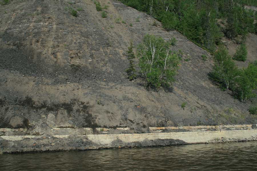
The embankment of Athabasca River near Fort McMurray reveals the dark grey oil sands of the McMurray Formation (classified as Lower Cretaceous) sitting on the white limestone of the Waterways Formation (classified as Middle Devonian). This implies a massive time gap yet the strata in the formations are parallel.
Heavy oil is what is left of crude oil (a natural mixture made mostly of hydrocarbons of various molecular weights) when the lighter components are naturally removed. It appears as semi-solid bitumen (a Latin word possibly of Celtic origin; the Greek equivalent is asphaltos) and is found tightly adhering to the surface of quartz grains in sands, hence the name “oil sands”. The natural removal of lighter components is believed to happen through bacterial activity, water, air, or a combination of them.2
The COS are found in northern Alberta in several areas, of which the Athabasca oil sands belt is the largest. The oil sands are mined/quarried on the surface, transported by huge trucks to plants where they are heated (by steam) until the oil is separated from the sand grains. The process requires the burning of natural gas (to produce the steam) and about 6 barrels of water for each barrel of processed oil. The water is contaminated with oily residue and has to spend a long time in large tailings ponds for the residue to settle. The ponds represent a threat to water fowl so that gas cannons are automatically fired at intervals to keep the birds from landing in the hazardous water. Reclaiming the land after oil sands have been removed is an ongoing process with its ups and downs.
When, how, why?
The sands have yielded plesiosaur fossils, which is why the oil sands of the McMurray Formation (MMF) have been placed in the Aptian (Lower Cretaceous period). Since the 1970s the McMurray Formation has been interpreted as being deposited in an estuary,3 with a gradual upward transition from fresh water deposits, through brackish-water to shallow marine. One argument for this model is based on the inferred valley-shaped surface upon which the sands lie. This is known as the “Sub-Cretaceous unconformity” as the sediments immediately underneath the sands have been assigned a Devonian age, so that a massive time gap exists between the two according to evolutionary geology. A second argument for the model is the presence of small tubular features in the sediments. These are interpreted to be burrows left in the sediments by some unknown creatures that are believed to have lived in a brackish-water environment. Finally, rhythmic tidal deposits are interpreted as shallow marine. Although the standard working hypothesis, the estuarine model is seldom if ever confirmed by data in the field, a prediction of a given type of rock at a future location being almost always anybody’s guess.
Recent isotopic studies attribute the oil formation to the same Cretaceous age as the sands.4 There are a number of different interpretations regarding the formation of the heavy oil sands, many placing the source rock (where the oil originally formed) deep in the sediments at the foot of the Rockies whence the oil later migrated eastward during the Laramide orogeny along the Sub-Cretaceous unconformity.5 During the migration, the lighter fractions were slowly biodegraded.6 Conventional oil is also found below the sands in Devonian limestones, and some geologists believe that a part of that oil was somehow squeezed upwards into the overlaying Cretaceous sands, rather than having laterally migrated simultaneously into the limestones and overlaying sands.
In the Fort McMurray area the sands rest unconformably on top of the carbonaceous Waterways Formation (WF) of Middle Devonian “age”.7 The scientific literature labels this as an “angular unconformity truncating Devonian strata”, i.e. cutting older layers that dip at a different angle. During a jet boat trip on the Athabasca River, the image I saw and documented was rather different. The sands lie on top of horizontal layers of limestone and marls, which contain fossils that may be attributed to a Devonian age, according to the standard geologic timetable. There is no sign of erosion on the uppermost Devonian layers, not even on a small scale. Since there is a time gap of 260 million evolutionary years between the two formations, the boundary between the oil sands and the Waterways Formation (i.e. the Sub-Cretaceous unconformity—SCU henceforth) is in fact a “paraconformity”.8 According to some estimates, based on data from many exploration wells, the SCU covers over 1,000,000 km2.9
Some problems with the evolutionary model
The paraconformity
Most of the existing scientific literature speaks of a paleorelief (ancient landscape) on top of the WF, based on interpretations of data coming from drill cores in exploration wells. However, frustrated with the inconsistencies in the field, some experienced geologists started doubting the validity of the estuary model and made rather abrupt statements about drill core data: “the facies distribution within the McMurray Formation is too complex to be understood in cored datasets.” What happens here is that when proceeding to interpret data from drill cores, geologists first need to have a model of the ancient environment in which the cored sediments were deposited. With this in their mind they then interpret the data from the cores consciously or subconsciously to fit the model and no alternative interpretation is even considered. On the other hand, when geologists can see the SCU in the embankments along the Athabasca River, they interpret the horizontal character of the boundary as a “local oddity”—a happenstance. They “know” it is actually an unconformity; i.e. there is an ancient, buried landscape there, and the strata below it are usually dipping—not horizontal like at that particular location they can see. It’s not much different from the way documented fast-growing stalagmites in show caves are considered as “exceptional” and the calculated long radiometric ages as the standard—a case I have often encountered.
There is another issue with the standard interpretation: according to evolutionary geology, from the Middle Devonian to the Aptian there have been 3 orogenies (mountain-building periods) that affected the Rockies (whence the sands of the MMF are believed to have originated). These are:10
| Orogeny | Evolutionary age (Ma ago) | |
| 1 | Sonoma | 270–240 |
| 2 | Nevadan | 180–50 |
| 3 | Sevier | 140–50 |
According to standard geology, such major tectonic events were always associated with massive erosion in the newly-built mountains and consequently sediment transport and deposition in the adjacent areas (“foreland” in geological parlance). Well, the MMF is supposed to be exactly that, the foreland of the Rockies. Why then was no sediment laid on top of the WF for 260 million years? And if there were sediments deposited, what removed them, since there is no physical evidence of extensive erosion? Maybe there is no 260-million-year gap after all!
The paleoenvironment
We have already mentioned that some geologists doubt the estuary model for the depositional environment of the MMF. And there is more to question than the drill core interpretation. Trace fossils (impressions made by living animals), also called ichnofossils or “ichnites”, are one of the most classical cases of vested bias in interpretation of facts in geology. In fact “ichnology” has gotten to the point of giving Latin names to traces without knowing which creature produced them!11 So how can someone positively deduce that certain tubular features like Gyrolithes, Cylindrichnus, Skolithos, Arenicolites, and Planolites found in the MMF are indeed ichnites of unknown creatures that are brackish-water dwellers? They could have been produced in any watery environment.
Oil migration
Whatever rocks the oil formed in, they must be older than the Cretaceous rocks because, according to the only accepted oil-formation theory—the “biogenic theory”—huge amounts of small dead creatures and plants had to accumulate, be covered by thick sediments and sink to depths where the temperature and pressure was high-enough to turn them into oil. Yet, as we have seen, there are no sediments in the area between the Cretaceous and the Devonian! And one has to twist existing geological information a lot to somehow infer the existence of such rocks, somewhere between the Rockies and Fort McMurray. However, if the oil has actually ascended from much a greater depth, as the competing (but utterly rejected) “abiogenic theory”12 of the origins of oil postulates, the aforementioned conundrum ceases to exist. Oil has simply ascended from below the WF, accumulated in its cavities and continued to move upwards, into the MMF.
A creationist alternative
If the abiogenic theory is correct—and there are many reasons why that may be the case—the source of oil can be placed deep inside the earth, in areas that have never been directly affected by the Genesis Flood waters. As the sediments of the Flood accumulated and because plate tectonics was now in place, oil started its migration along deep fault lines in the crust. From there it seeped up into the newly-laid sediments above and accumulated wherever conditions were right (stratigraphic and structural traps). As oil is still produced today inside the earth, it continues to seep so that even some oil reservoirs once considered “empty”13 can actually recharge, and have done so. Of course, the pathway that the oil follows may change—the crust is a rather dynamic environment—so some of today’s known oil reservoirs may no longer be connected to the deep source.

The contact between the oil sands and the subjacent Devonian limestone of Waterways Formation. The tar (bitumen) slowly and constantly oozes out the banks, sometimes rolling down the slope in little tar balls. Note the ‘Sub-Cretaceous Unconformity’ which assumes the Devonian layers are dipping at a different angle from the sands. In fact they are both horizontal. This is a paraconformity, where the strata above and below the gap are parallel and there is no evidence of erosion.
In this view, the COS are the result of oil infiltrating into the sediments (most probably vertically) along a continuous fault line separating the Rockies from the eastern foreland. The Devonian limestones have retained as much of this oil as their porosity has allowed but the “overflow” kept ascending. If the sands in the MMF were capped by some impervious sediment, nothing should have stopped the oil seeping into the whole basin throughout 112 million evolutionary years. However, COS are in fact only in several areas of a much vaster sedimentary basin.
There was however one significant seal during the Quaternary: the ice cap. Reaching its maximum extent about 500 years after the Flood,14 the ice cap acted not only as a solid cap but because of the cooler temperatures at its base it increased the viscosity of the oil so that seepage slowed down. Furthermore, in the later stages of the Ice Age as the ice cap was retreating, meltwater accumulated at the bottom of the ice cap to be released eventually in sudden catastrophic bursts. These outbursts would have created a vacuum/suction behind them,15 which could have facilitated increased oil migration from the subjacent COS. Over the years, as the ice cap further receded, some of the under-ice meltwater channels became the rivers of today that have cut through the soft sands all the way down to the subjacent Devonian limestone, a situation that is now clearly visible. Such a setting and the much shorter time available for seepage can easily account for the patchy, rather than continuous extent of the COS.
Such a complex geologic feature, one that has major economic value, once again proves to be consistent with a young planet. While it is possible for geologists to find oil today using either the evolutionary or the creationary model, the latter offers simple solutions to many inconsistencies with the former.
Acknowledgements
A would like to thank my friends at Fort McMurray, Mark Nystrom, Chris Reitz and Glen Forsberg for changing the status of a boat trip up on the Athabasca River from a dream to reality.
References
- Eyles, N. and Miall, A., Canada Rocks, the Geological Journey, Fitzhenry & Whiteside LTD, Markham, Ontario, 2007. Return to text.
- Heavy crude oil, Wikipedia, accessed 1 September 2010. Return to text.
- Gingras, M. and Rokosh, D., A brief overview of the geology of heavy oil, bitumen and oil sand deposits, 2004 CSEG National convention, accessed 1 September 2010. Return to text.
- Researchers first in the world to discover the age of oil, PhysOrg.com, accessed 1 September 2010. Return to text.
- Laramide orogeny, Wikipedia, accessed 1 September 2010. Return to text.
- Job, M., Geology and geological uncertainty of Alberta oil sands, 2007, www.see.ualberta.ca/pdfs/Uncertainty of Alberta Oil Sands - Job.pdf, accessed 1 September 2010. Return to text.
- Buschkuehle, B.E., Sedimentology and stratigraphy of Middle and Upper Devonian carbonates in northern Alberta, Alberta Geological Survey and Alberta Energy and Utilities Board, July 2003, accessed 1 September 2010. Return to text.
- Sarfati, J., ‘Millions of years’ are missing: Jonathan Sarfati interviews biologist and geologist Arial Roth, Creation 31(2)46–49, 2009. Return to text.
- Lickie, D.A., Anatomy of the Basinwide Sub-Cretaceous Unconformity, Western Canada Foreland Basin, AAPG Annual Convention and Exhibition, Denver, Colorado, June 7-10, 2009; accessed 1 September 2010. Return to text.
- List of orogenies, Wikipedia, accessed 1 September 2010. Return to text.
- Silvestru, E., Human and dinosaur fossil footprints in the Upper Cretaceous of North America? Journal of Creation 18(2):114–120, 2004. Return to text.
- Focus: Gushing oil surprise, Creation 27(3):6, 2005. Return to text.
- One has to remember though that no recovery methods—even when combined—can retrieve more than up to 65% of the oil in a natural reservoir Return to text.
- Batten, D. (ed.), Creation Answers Book, What about the Ice Age?, Creation Book Publishers, Powder Springs, GA, pp. 201–212, 2007. Return to text.
- Silvestru, E., Wild, wild floods!, 5 September 2007. Return to text.


Readers’ comments
Comments are automatically closed 14 days after publication.