

Do rivers erode through mountains?
Water gaps are strong evidence for the Genesis Flood


Many rivers, after travelling along a valley, suddenly turn and flow through a narrow gorge that cuts through a mountain range, a ridge, or a plateau. Such gorges are called water gaps. It looks like the river cut the gorge, but how could it? Surely, if the river had carved the landscape slowly over long ages, it would have flowed around the barrier instead of flowing through it. So was the gorge eroded first by something we don’t see happening today?
Water gaps worldwide
Numerous water gaps occur in Europe.1 They also occur in South America, Australia, Africa, New Zealand, China, and many other areas. In other words, they are worldwide, occurring in most mountain ranges:
‘Since these early studies [done in the late 19th century] transverse drainage have been identified from most major mountain belt regions around the world … ’.2
Eurasia
The deepest water gaps in the world are in the Himalaya Mountains. Eleven major rivers start on the southern Tibetan Plateau and pass through the mountains in very deep gorges.3,4 The Arun River flows south past Mount Everest in a water gap that is over 6 km (4 miles) deep.
The Zagros Mountains can rise as high as 3,350 m (11,000 ft) to 4,575 m (15,000 ft) above sea level in western Iran. These mountains are 1,600 km (1,000 miles) long and about 250 km (150 miles) wide. The Zagros Mountains are unique in being geologically ‘young’ and little modified by erosion. Three hundred water gaps split these mountains in gorges up to 2,440 m (8,000 ft) deep.5 The lower walls of some water gaps are near vertical, sometimes overhanging. The most impressive aspect of the Zagros drainage is that the streams and rivers appear to shun valleys, and prefer to transect mountains—numerous times:
‘The Zagros drainage pattern is distinctive by virtue of its disregard of major geological obstructions, both on a general scale and in detail. … Certain streams ignore structure completely; some appear to “seek” obstacles to transect; others are deflected by barriers only to breach them at some point near their termini. Many streams cut in and out of anticlines [ridges] without transecting them completely, and a few cross the same barrier more than once in reverse direction.’6
United States
There are myriad water gaps, small and large in the western United States:
‘In numerous places, especially in the Southern and Middle Rockies, rivers cut across uplifts cored by resistant rocks in preference to what appear to be more logical courses on softer rocks around the uplifts.’7
For instance, Hells Canyon cuts through the Wallowa Mountains in northeast Oregon and the Seven Devils Mountains in Idaho.8 This water gap is the deepest in North America. Measured from the Idaho side, one segment of the canyon is 2,440 m (8,000 ft) deep. The Snake River flows westward in southern Idaho and then takes a right turn and flows 145 km (90 miles) through the gorge.
The Shoshone water gap through the Rattlesnake Mountains west of Cody, Wyoming, is 760 m (2,500 ft) deep (figure 1). The Shoshone River starts in Yellowstone Park and flows east without deviation straight through the Rattlesnake Mountains. We would have expected the river to have taken the easiest route, south around the Rattlesnake Mountains and through a low spot (figure 2).9
Water gaps are numerous through the Appalachian Mountains.10 This area is outstanding for the study of water gaps: ‘The Appalachian Valley and Ridge Province is the classic area for the problem of rivers cutting through the narrow ridges of fold-thrust belts.’11 One of the most famous series of water gaps is the Susquehanna River cutting through the eroded Appalachian Mountains north of Harrisburg, Pennsylvania (figure 3). The Susquehanna River passes right through multiple ridges with little deviation from its course.
Australia
Many water gaps are found in Australia. Just west of Sydney, the Nepean River flows through one. In Central Australia, the Finke River flows across at least three ranges, the rims of which have been ‘dated’ at some 400 million years old. How such erosive processes could have continued for so long defies credibility, but rather than questioning the dates, evolutionist geologists now tout the Finke River as being the oldest river in the world.
Origin of water gaps a major mystery
There are many hypotheses for the origin of water gaps based on slow processes of erosion over millions of years. However, these ideas are rarely based on evidence. Thomas Oberlander has many sobering thoughts about research on water gaps:


‘ … the question of the origin of geological discordant drainage [water gaps] has almost always been attacked deductively, leading toward conclusions that remain largely within the realm of conjecture’ (Emphasis added).12
Water gaps explained by the retreating floodwater
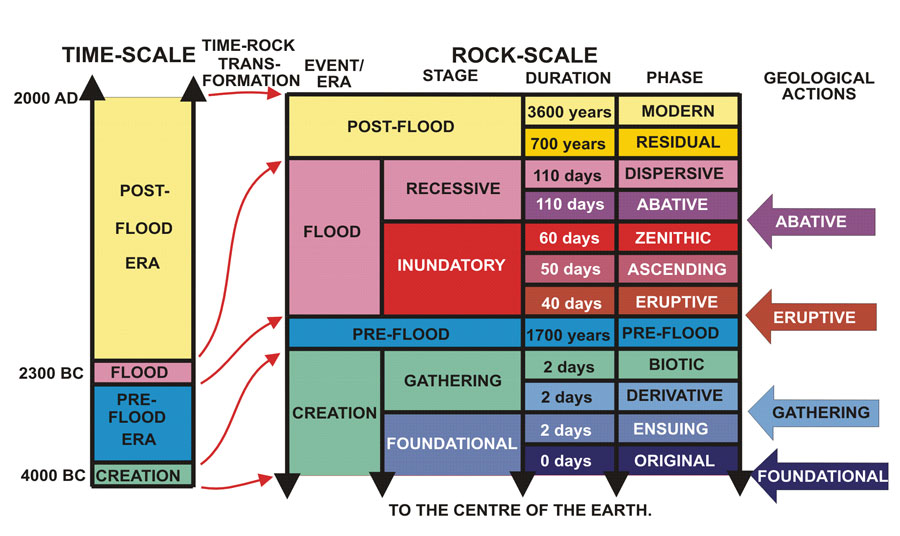
The biblical Flood provides a simple solution. After the whole globe was covered,13 the mountains rose and the valleys sank, so the water ran into the current oceans (cf. Psalm 104:8, NASB).14 At first, the water would have flowed in enormous sheets, and this explains the many planation surfaces that look like someone took a giant plane to the terrain and shaved it flat.15 This is sometimes called the Abative, or Sheet phase of the Flood (figure 4).16
As the water flow reduced, flow concentrated into huge channels, which had the potential to erode valleys and gorges. This was the Dispersive or Channelized phase.16
Since water gaps are located on the surface of the Earth, and formed after much erosion of the land had already taken place, they were cut during the Dispersive phase. They would form rapidly whenever channelized floodwaters flowed perpendicular to a barrier (figure 5).
Example from the Lake Missoula flood
Is there any evidence that water gaps were cut during the Channelized phase of the Genesis Flood? One example is a water gap formed in the gigantic Lake Missoula flood in Washington State.17 At the peak of the Ice Age, an ice dam in northern Idaho formed glacial Lake Missoula. The lake was 610 m (2,000 ft) deep when the dam broke. It emptied in a few days. Water over 100 m (300 ft) deep rushed through eastern Washington, carving canyons up to 300 m (almost 1,000 ft) deep.
The Palouse River, rising in the mountains of northern Idaho, used to flow westward through Washtucna Canyon and eventually into the Columbia River (figure 6). The Snake River flows parallel to Washtucna Canyon about 16 km (10 miles) south separated by a basalt lava ridge. The Lake Missoula flood rushed into Washtucna Canyon and overtopped the ridge in two places. The eastern breach eventually eroded into a narrow, vertically walled canyon 150 m (500 ft) deep.
After the flood, the Palouse River, instead of continuing to flow westward down Washtucna Canyon, as before, now takes a 90° left hand turn. It flows through the ridge in a gorge called Palouse Canyon and into Snake River. Palouse Canyon, occupied by Palouse Falls (figure 7), is now a water gap formed during the Lake Missoula flood.
The post-Flood Palouse River and Canyon show how water gaps would have eroded rapidly in the monstrously larger Genesis Flood. Since these water gaps are worldwide and occurred at about the same time geologically, they show that the Genesis Flood was global, not local.
Some landscape terms
Anticline: An upward fold of sedimentary strata that usually forms a long ridge (the opposite of syncline).
Discordant drainage: Where rivers and streams flow across the direction of the mountains and ridges, rather than in the same direction.
Planation surface: A level land surface that has been planed flat by flowing water, often on underlying geological strata that dip at an angle to the surface.
Plateau: An area of high, flat ground, a tableland.
Transverse drainage: Same as discordant drainage.
Water gap: A deep pass through a mountain or ridge that is occupied by a river or stream.
Re-posted on homepage: 18 April 2018
References and notes
- Embleton, C. (Ed.), Geomorphology of Europe, John Wiley & Sons, New York, 1984. Return to text.
- Stokes, M. and Mather, A. E., Tectonic origin and evolution of a transverse drainage: The Río Almanzora, Betic Cordillera, Southeast Spain, Geomorphology 50:61, 2003. Return to text.
- Oberlander, T. M., Origin of drainage transverse to structures in orogens; in: Morisawa, M. and Hack, J. T. (eds.), Tectonic Geomorphology, Allen and Unwin, Massachusetts, USA, p. 156, 1985. Return to text.
- Fielding, E. J., Morphotectonic evolution of the Himalayas and Tibetan Plateau; in: Summerfield, M. A. (ed.), Geomorphology and Global Tectonics, John Wiley & Sons, New York, p. 205, 2000. Return to text.
- Oberlander, T., The Zagros Streams: A New Interpretation of Transverse Drainage in an Orogenic Zone, Syracuse Geographical Series No. 1, Syracuse, New York, 1965. Return to text.
- Ref. 5, pp. 1, 89. Return to text.
- Madole, R. F., Bradley, W. C., Loewenherz, D. S., Ritter, D. F., Rutter, N. W. and Thorn C. E.; in: Graf, W. L. (Ed.), Geomorphic Systems of North America, Geological Society of America, Centennial Special Volume 2, Colorado, USA, p. 213, 1987. Return to text.
- Vallier, T., Islands & Rapids: A Geological Story of Hells Canyon, Confluence Press, Idaho, USA, p. 7, 1998. Return to text.
- Figure 2 is a view to the south across Buffalo Bill Reservoir, 100 m (330 ft) high, just west of the Shoshone Water Gap. The low spot to the south is so low that engineers had to build a dam to keep the water of the reservoir from spilling south. There is an irrigation canal that starts at this southerly dam and flows into the Bighorn Basin. Return to text.
- Ahnert, F., Introduction to Geomorphology, Arnold, London, p. 202, 1998. Return to text.
- Alvarez, W., Drainage on evolving fold-thrust belts: A study of transverse canyons in the Apennines, Basin Research 11:267–268, 1999. Return to text.
- Ref. 5, p. 1. Return to text.
- Batten, D., (ed.), et al., The Creation Answers Book, ch. 10, Creation Ministries International, Queensland, Australia, 2006. Return to text.
- Ref. 13, ch. 12. Return to text.
- Oard, M.J., It’s plain to see: flat land surfaces are strong evidence for the Genesis Flood, Creation 28(2):34–37, 2006; creation.com/plain. Return to text.
- Walker, T., A biblical geologic model; in: Walsh, R.E. (ed.), Proceedings of the Third International Conference on Creationism, Creation Science Fellowship, Pittsburgh, Pennsylvania, pp. 581–592, 1994; biblicalgeology.net/. Return to text.
- Oard, M.J., The Missoula Flood Controversy and the Genesis Flood, Creation Research Society Monograph Series No. 13, Arizona, USA, pp. 110–111, 2004. Return to text.


Readers’ comments
Comments are automatically closed 14 days after publication.