
Karst mountains, Guangxi, China, and Noah’s Flood

Joseph A. from the United States writes:
My question that I would like to ask is: how do you believe the Jasper Forest in South-western China was formed? As a Christian I believe fully in the Bible because it is God’s written word and is thus all true. I just can’t wrap my head around how the Jasper Forest was formed in such a way by the flood. The hill/mountains are very round and tightly together. I’ve read “The Miracle Planet” by Bruce Brown and Lane Morgan and it says that “Four hundred million years ago a warm ocean covered the Guangxi region of China” (Brown, p. 104). I know that the ocean was probably the flood covering the land. It’s the next part that I can’t wrap my head around. Apparently the movement of plate tectonics caused cracks in the ground which then acid rain filled and dissolved the limestone. This created the water caverns and caves. From there erosion sharpened the appearance of the hills. Sorry for the inconvenience if my question was already answered in other documents. I would be ecstatic if the members of CMI answered.
CMI geologist Dr Tas Walker writes:
Hi Joseph,
I’ve not done detailed research on the Jasper Forest in South-western China. However, to reply to your email I found some information on the Guangxi region (Guizhou, Guangxi, Guilin), which shows some of the stunning scenery in the area, including the rounded hills you mention. The area sounds interesting, and one day I would like to research more of its features.
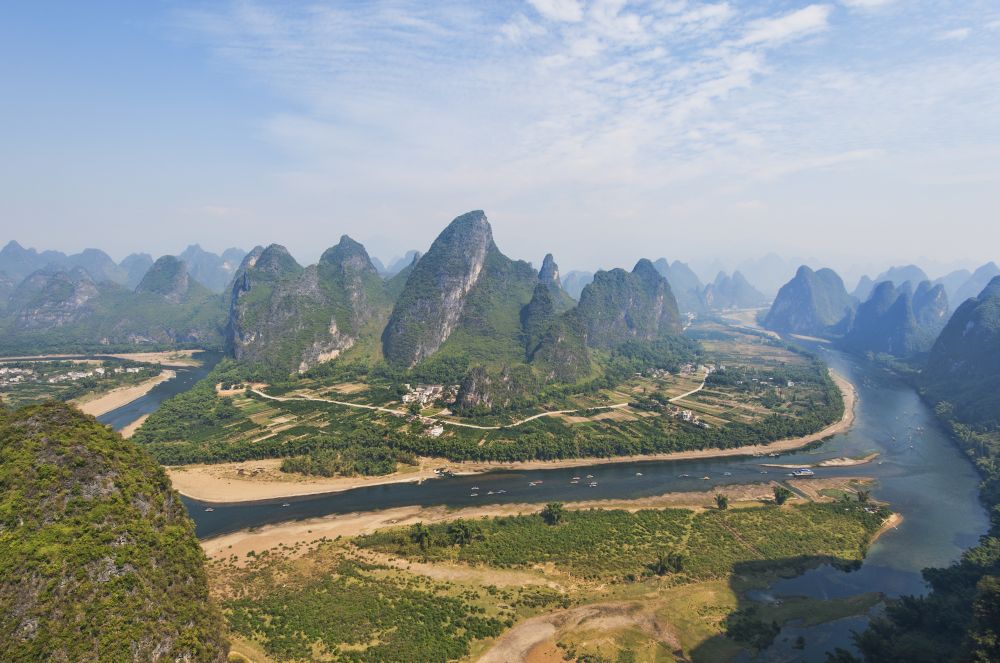
The rounded hills and caves you mention are typical of limestone country. (You mention limestone in your email.) The Guangxi Province is famous for these rounded hills, with 70,000 of them clustered along the Li River in Southern China. Limestone which has been eroded in this manner is referred to as karst.
When you are trying to understand an area from a Flood perspective it is important to understand the Flood sequence, and this is set out in the biblical geological model (see figure). Look at the charts (see pdf summary), and picture in your mind what happened in the area during the Flood.
When the book says 400 million years ago that translates into the first ‘half’ of the Flood. It would be after the initial break-up and initial catastrophic cataclysm, but well before the waters reached their peak. They may have decided this ‘age’ based on the fossils, or they could have decided it by its relationship with other rocks in China, or both. See the articles The geological column is a general Flood order with many exceptions and The geological history of the Brisbane area, Australia, for how the geologic column related to biblical geology.

When they say “ocean”, they are actually referring to evidence for the Flood, but the Flood was not an ocean as we experience oceans today. The Flood involved a cataclysm, with deep water moving over the surface of the earth from place to place quite rapidly, eroding rocks, transporting the eroded material, and depositing the sediment in other areas.
When they say “warm” it may be because of the limestone that was being deposited. They typically imagine the limestone came from the breakup of coral reefs which grow in warm oceans today. However, the connection with coral reefs is not likely to be the whole story during the Flood. It is more likely that the limestone was mostly chemically deposited at that time. Or, they may have said “warm” because of the types of fossils they found.
If the water at the time was indeed warm, that may have been because of the volcanic eruptions that occurred at the beginning of the Flood. However, it is possible that it may not have been warm but the environment has been misinterpreted. You would have to do more research to work out why they are making these interpretations.
There would have been more sediment deposited on top of these rocks as the Flood continued to rise (including sediments in central China where they are finding dinosaur fossils). Eventually the Floodwaters would have peaked, after which they would have started to recede from the continents into the newly-forming ocean basins. This receding water during the second ‘half’ of Noah’s Flood would have eroded the sediment from the top of the continents, likely kilometres of sediment as is evident in other parts of the world. (See this article, which discusses one aspect of the Receding stage of the Flood in China.)
The remarkable landscape with its rounded hills was carved by these receding floodwaters. The hills were likely eroded in an area where there was a change in the elevation of the land surface. Imagine the water flowing toward the ocean over the interior plateau and then dropping to a lower elevation. A hydraulic jump forms in the area where it drops, generating a region of aggressive erosion. The water flow across the continent would also have been affected by the geological structure of the area. You can explore some of these features using Google Maps and Google Earth.
As the water level dropped, corrosive fluids moved through the limestone and dissolved out the caves. Thus, the main cavern spaces most likely formed late in the Flood, and the interior decoration (stalactites and stalagmites) formed after the Flood due to groundwater seepage in the post-Flood period.
So that is a brief explanation in a broad sweep. It provides a starting point for further investigation, when you can confirm or modify the details. You can find more information in articles on creation.com by searching with relevant key words, by looking at the area on Google Maps and Google Earth, and by searching for material on the web.
All the best,
Tas Walker

Readers’ comments
Comments are automatically closed 14 days after publication.