

Rock language: is there such a thing?
Have you heard the saying ‘The rocks speak out’? But can you understand what they say?
Let’s see.
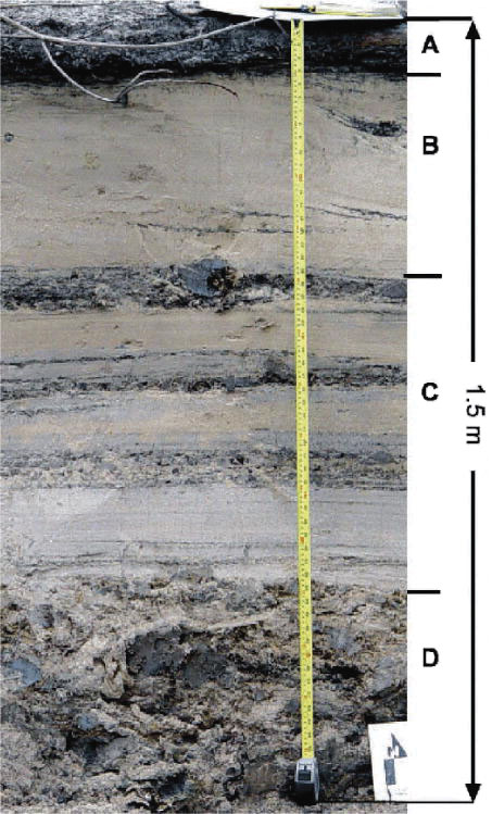
Look for a moment at the sedimentary deposit shown in the photograph (figure 1). It is 1.5m thick.
You can see the bottom portion of the deposit, marked D, is dark, massive and without any clear structure. The next section, marked C, has a few horizontal layers, some that are light coloured and others dark. Above that, the section marked B is made of mostly light sand, which looks like there are a few waves or dunes in it. The whole sequence is capped by a dark layer at the top, marked A.
Geologists interpret past environments from such exposures of rock. The idea is that the rocks tell us what happened in the past. But it is people who do the talking; the rocks are silent. That is, the interpretation is determined by perspective.
Let’s try to interpret these sedimentary layers shown in the section. This is what we could say:
‘The bottom sediments were deposited in shallow mudflats along an ancient coastline. Worms and other organisms, as they grazed for food in the mud, disturbed the sediment and left it without any clear structure.
‘As more sediment accumulated in the area, the shoreline gradually advanced seaward, and the mudflats were covered with beach sand. The flat strata were deposited in the zone on the beach that was affected by the tides. The dark and light strata represent periods of time when the ocean levels sometimes increased and other times decreased: a time of rapid small scale sea transgressions and regressions.

‘More sediment accumulated and the coast line continued to build seaward. Eventually the area was covered by small sandy dunes at the top of the beach. Gentle winds helped move the sand up the beach. Just beyond the sand dunes, in a perched lake environment, leaves and twigs from the vegetation in the area accumulated in a shallow marsh.’
You can see all this clearly in an illustration of the environment in figure 2.
Geologists routinely interpret past geological environments from the rock layers in this way. It’s part of their job. Here is an example of what they say about the so-called Carboniferous period, which they put at 300 million years ago:
‘Along the margins of the seas, quantities of detritus [accumulated fragments] from eroding mountain chains were carried down by rivers to form wide deltas and delta swamps.’1
We often read such interpretations in the media, in tourist brochures, and in school books. The descriptions can be vivid and almost give the impression that the geologists were there to see what was going on.
So, how do we rate our interpretation of the sand deposit in figure 1?
Not too well. Even though the interpretation was plausible and convincing, it is wrong.
In this case, we know how the sediments in figure 1 were deposited. People saw it happen. This sand was deposited in a New Orleans neighbourhood on 29 August 2005 as a result of Hurricane Katrina.2
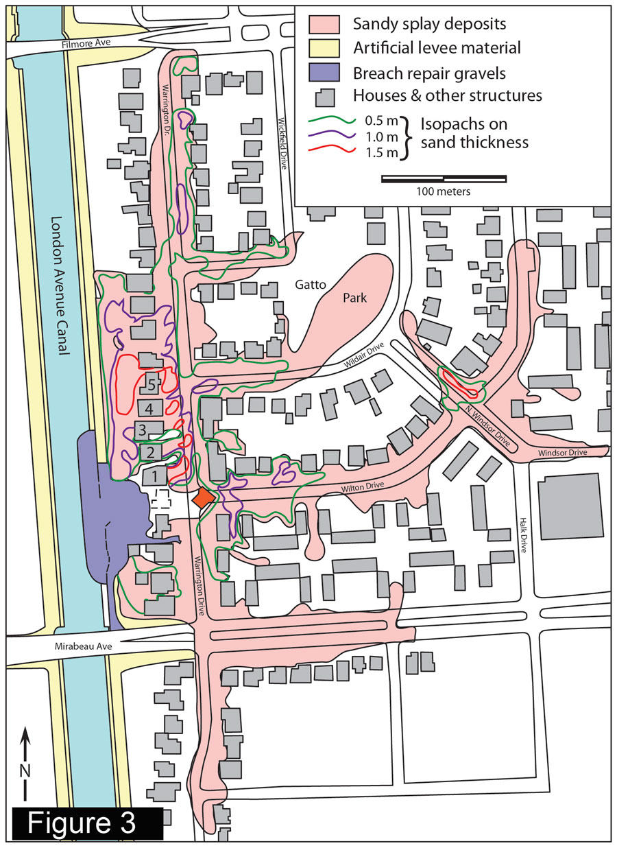
The hurricane produced a storm surge which burst the levee on the London Avenue Canal, flooding the area and depositing sediment as shown in figure3. The section we interpreted was photographed in front of house number 2 (labelled on figure) as workmen cleared the debris away.
The levee burst between 7 and 8 am, and the torrent of water was so powerful that it lifted one house from its foundation, moved it 35m (115 ft) into a tree, and turned it around (red house in figure 3). Repairs to the breach began after two days.
The whole 1.5m (5 ft) of sand was deposited quickly as water flooded into the neighbourhood. Rather than representing different environments over long periods of time, the sediments represent rapidly changing flow conditions.
The bottom section represents the first sediments carried into the area by the initial turbulent torrent. The flat layers above were deposited from a continuous flow of high-velocity water as the water level in the neighbourhood rose. The next section, with the sand dunes, was deposited when the water slowed down. And the organic twigs and leaves were left in a layer on the top.
The whole deposit was laid down quickly during one catastrophe in about a day.
Clare Bond from the University of Glasgow, and other researchers from the UK investigated human bias in geological interpretation. Consulting with over 200 professional geoscientists they found that a person’s previous experience affects how they interpret geological evidence.3 Industry needs to know what risks they face when making major decisions based on the interpretations of geological data.
Clearly, the way we interpret rocks depends on what we think happened in the past. Those who start with wrong ideas about the past will be wrong in their interpretation of the data—even if they have a detailed, plausible and consistent story.
The big risk is in not recognizing catastrophic deposits.
That is the situation with modern geology. Most geologists have decided from the outset that the huge catastrophe of Noah’s Flood did not happen.4 So they interpret the rocks in terms of stable environments over millions of years.
These explanations are often logical, detailed and plausible (although there are always things that don’t add up, but these are generally overlooked). However, we know that these explanations are wrong because of the eyewitness report in the Bible about the global Flood. And when we do take the Flood into account, we find that it makes good sense of the evidence.5
We must change the way we interpret the rocks, starting from the true history of the world as recorded in the Bible. Not only do we need better geological understanding, but more importantly we will see that the Bible is reliable and heed its life changing message.
References and notes
- Hallam, A., Planet Earth: An Encyclopaedia of Geology, Elsevier International, Oxford, UK, p. 206, 1977. Return to text.
- Nelson, S.A. and Leclair, S.F., Katrina’s unique splay deposits in a New Orleans neighborhood, GSA Today 16(9):4–10, September 2006. Return to text.
- Bond, C.E. et al., Human bias in geological interpretation—how much uncertainty does it introduce? AAPG International Conference and Exhibition, Technical Program, 5–8 November 2006, <aapg.confex.com/aapg/2006int/techprogram/A107418.htm>. Return to text.
- James Hutton (1726–97) was the first to assert, ‘The past history of our globe must be explained by what can be seen to be happening now’—the philosophy of uniformitarianism which excludes Noah’s Flood from the outset (quoted in Holmes, A. Principles of Physical Geology., Nelson, London, p. 43, 1965). Return to text.
- See for example Geology Questions and Answers, <creation.com/geology>. Return to text.
Readers’ comments
Comments are automatically closed 14 days after publication.