

Journal of Creation 22(1):12–14, April 2008
Browse our latest digital issue Subscribe
Wild, wild floods!
North Sea Megaflood
Recently the Brits have found out what really separated them from mainland Europe: catastrophic flooding! And not once but twice! Detailed studies of the bottom of the English Channel have revealed an ancient river valley that once collected the waters of the Thames, Somme, Rhine-Meuse and the Scheldt—rivers that all discharge today into the North Sea.1,2
High resolution imagery of the seafloor has not only revealed an ancient river but also clear signs of large-scale flooding (megafloods)—signs like flat-topped, elongated and streamlined islands up to 10 km long and 4 km wide, plus grooves nearly 200 m wide, 2–3 m deep and 10–15 km long.1
The flooding discharged an estimated 1×10⁶ m3 s–1 of meltwater from a pro-glacial lake located where the North Sea is today. Within the evolutionary (long-age) timeframe, the first flooding event is believed to have occurred about 425,000 years ago during the Ice Age. In my view, however, the first erosional event was the receding water of Noah’s Flood3 (~4,500 years ago, Genesis 8) cutting a deep canyon through the landbridge that then connected Europe and the British Isles, a structural ridge known as the Weald-Artois anticline made almost entirely of chalk.
Then, at the end of the last episode of intense freezing (believed by evolutionary scientists to have taken place 20,000 years ago) an even larger meltwater lake formed north of the canyon which is believed to have been dammed by moraines or some other obstacle. At some point the dam breached and a flood which they claim was even greater than the previous one4 scoured away all that remained of the structural ridge, creating the English Channel as we know it today.1,2
History repeated
This newly accepted megaflood is the last one in a series that began to make its way into the scientific establishment over 80 years ago; when J Harlen Bretz proposed that the Channelled Scablands in Washington State were caused by a gigantic flood.5 Bretz was derided and his idea utterly rejected for nearly 50 years. Now the Lake Missoula flood is a widely accepted explanation and even believed by some to have been a cyclical event!6
Then came the Lake Agassiz flood: a gigantic meltwater lake that formed at the southern edge of the Laurentide Ice Sheet in Canada and suddenly drained catastrophically eastward, cutting the Niagara Gorge and the St Lawrence River in a geological instant.7,8 Further studies in Canada have shown that gigantic floods had also repeatedly occurred underneath the ice sheet.9,10
My research along the Niagara Escarpment has revealed that such subglacial sheetfloods were most likely responsible for the formation of this famous landmark. West of Lake Agassiz, at the foot of the Rockies in Alberta, another massive subglacial flood seems to have shaped most of the foothills and possibly the Rockies themselves.9,11,12
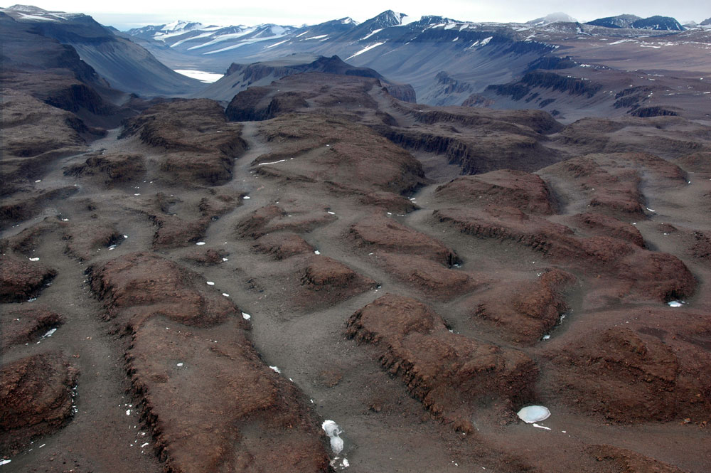
As this iconoclastic idea was gaining momentum, traces of similar floods have been found in places like Antarctica. Weird landscapes like the Labyrinth in Antarctica’s Western Dry Valleys are now attributed to ‘extensive subglacial floods’ (please notice the plural!) in the middle Miocene (long before humans were around according to evolutionists).13
All of these floods have had estimated discharges of the same order of magnitude as the one that created the English Channel. Such a huge input of fresh water into the oceans would have certainly affected the thermohaline circulation system7,14 and through that the global climate.
What next?
It is interesting to notice that the North Sea flood (I will tentatively use this appellative here) is a latecomer in the geosciences, although it is physically located in the cradle of modern geology! The fact that the data is located under the sea should not be an excuse. This is not any sea but the English Channel, arguably the most investigated seafloor in the world!
I believe it has more to do with Lyell’s lingering ghost of which the late Derek Ager—an enemy of creationism!—said in the preface of his last book (seen by many as his scientific testament):
“Just as politicians rewrite human history, so geologists rewrite earth history. For a century and a half the geological world has been dominated, one might even say brain-washed, by the gradualistic uniformitarianism of Charles Lyell. Any suggestion of ‘catastrophic’ events has been rejected as old-fashioned, unscientific and even laughable.”15
There may be another reason for the late recognition of European glacial and subglacial floods: the mountains. In North America (where most of the glacial and subglacial floods have been documented) the mountain ranges run north-south or north-east–south-west and are located at the edges of the continent. Thus there was no mountainous barrier for either the ice sheet growing southward from the Arctic, or the meltwater it produced when the Ice Age ended.
In Europe (where the ice sheet also advanced from the north) on the other hand, the Pyrenées, Alps, Tatras and Carpathians created a massive east-west barrier from the Atlantic to the Black Sea (continued beyond by the Caucasus, Karakorum and Himalayas). This barrier effectively stopped the advance of ice and when meltwater accumulated behind it, may have directed most of it towards the western and eastern ends of the obstacle. It is therefore possible that the North Sea flood was fed by more than just local meltwater.
There is another interesting possibility: the Black Sea flood being caused not by invading Mediterranean Sea waters (as believed by the advocates of this catastrophic event16) but by meltwater running east and then south across the Ukrainian steppe and into the Black Sea. This could have caused the Black Sea to overflow eastward, cutting or deepening the Bosporus. Maybe the Caspian and Aral seas were also formed this way. Nobody has yet searched for traces of such a glacial or subglacial flood in Eastern Europe, but given the incredible momentum of this neo-catastrophic approach, it may happen anytime now!
Conclusion
Clearly, there is an increased willingness for the evolutionary geology establishment to accept catastrophes within geological history (‘the rare event’ as Ager calls it). However, the establishment is adamant that these catastrophes were isolated and widely spaced in time. So, whenever catastrophes are recognized, they have to fit the long-age geologic timetable (‘reinforcement syndrome’).
All these floods were a consequence of the Quaternary Ice Age, for which creationists have the only plausible explanation. The Ice Age occurred after the Genesis Flood and was a result of it. Furthermore, the post-Flood Ice Age was unique (in spite of the fact that some evolutionists have postulated up to 40 glacial events during what we call the Ice Age17).
Within the biblical timeframe, all these catastrophic floods occurred close to each other and their cumulative effect on global climate must have been dramatic. Semi-closed seas like the Mediterranean, the Black Sea and the Red Sea could have been ‘flooded’ and/or overflowed repeatedly.
According to existing climate models,13 such an input of freshwater would have caused significant global cooling, and that is exactly what the Younger Dryas episode13,18 at the end of the Ice Age was, seemingly on a global scale.19 Another consequence was the rapid rise in ocean level which would have rapidly isolated lands that were previously connected. Humans and animals would have been suddenly isolated, allowing for the development of the present-day demography and biogeography.
Studying the multiple effects of these post-diluvial floods can provide valuable data pertaining to many aspects of Earth history, from the dynamics and effects of Noah’s Flood to dispersal of humans after the Tower of Babel episode. The facts are out there for all to study and use to further the Kingdom! Willingness and funding is all that’s needed!
Re-posted on homepage: 12 February 2016
References and notes
- Gibbard, P., Europe cut adrift, Nature 448(7151):259–260, July 2007 | doi:10.1038/448259a. Return to text.
- Gupta, S., Collier, J.S., Palmer-Felgate, A. and Potter, G., Catastrophic flooding origin of self valley systems in the English Channel, Nature 448(7151):342–346, July 2007 | doi:10.1038/nature06018. Return to text.
- Batten, D. et al., The Creation Answers Book, CMI, Brisbane, ch. 16 (What about the Ice Age?), 2006. Return to text.
- Noah’s Flood was of course the greatest Flood in Earth history, but it is possible that some post-Flood catastrophic flows exceeded the last vestiges of the receding flows of Noah’s Flood. Return to text.
- Bretz, J.H., The Spokane Flood beyond the Channelled Scablands, J. Geology 33(2):97–115, 236–259, 1925. Return to text.
- Oard, M.J., Only one Lake Missoula flood, J. Creation 14(2):14–17, 2000. Return to text.
- Broecker, W.S., Kennett, J.P., Flower, B.P., Teller, J.T., Trumbore, S., Bonani, G. and Wolfli, W., Routing of meltwater from Laurentide Ice Sheet during the Younger Dryas cold episode, Nature 341(6240):318–321, September 1989 | doi:10.1038/341318a0. Return to text.
- Silvestru, E., Climate change, Niagara and catastrophe, April 2006; creation.com/niagara-climate. Return to text.
- Shaw, J., A meltwater model for Laurentide subglacial landscapes; in: Geomorphology sans Frontière, McCann, S.B. and Ford, D.C., (Eds.), Wiley, Chichester, pp. 182–226, 1969. Return to text.
- Shaw, J., The meltwater hypothesis for subglacial bedforms, Quaternary International 90:5–22, 2002. Return to text.
- Shaw, J. and Kvill, D., A glaciofluvial origin for drumlins of the Livingstone Lake Area, Saskatchewan, Canadian Journal of Earth Sciences 21:1442–1459, 1984. Return to text
- Shaw, J., Faragini, D., Kvill, D.R. and Rains, R.B., The Athabasca fluting field, Alberta, Canada: Implications for the formation of large-scale fluting (erosional lineations), Quaternary Science Reviews 19:959–980, 2000. Return to text
- Lewis, A.R., Marchant, D.R., Kowalewski, D.E., Baldwin, S.L. and Webb, L.E., The age and origin of the Labyrinth, western Dry Valleys, Antarctica: Evidence for extensive middle Miocene subglacial floods and freshwater discharge to the Southern Ocean, Geology 34(7):513–516, 2006; su-thermochronology.syr.edu. Return to text
- Mechanisms that can cause abrupt climate change, ncdc.noaa.gov. Return to text
- Ager, D., The New Catastrophism: The importance of the rare event in geological history, Cambridge University Press, Cambridge, p. xi, 1993. Return to text
- Walker, T., The Black Sea flood: Definitely not the Flood of Noah, J. Creation 14(1):40–44, 2000. Return to text.
- Billard, A., Analyse Critique de Stratotyope Quaternaire, Edit, CNRS, Paris, 1987. Return to text.
- The Younger Dryas, American Geophysical Union, 1995, agu.org. Return to text.
- Rutter, N.W., Is the Younger Dryas global in extent? 2003 Seattle Annual Meeting, Paper 132-1, 2003. gsa.confex.com. Return to text.


Readers’ comments
Comments are automatically closed 14 days after publication.