

Coal: memorial to the Flood

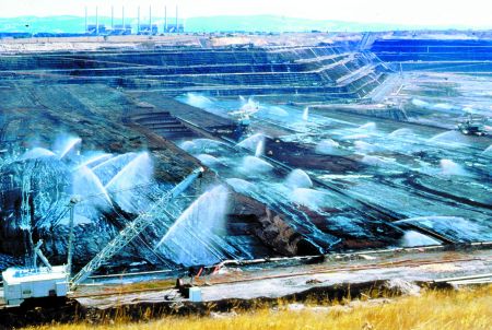
South-East Australia’s Latrobe Valley has some extremely thick deposits of brown coal which are mined to fuel several huge power stations. One bucket-wheel excavator removes the relatively thin overburden and exposes the coal seam. Another excavator digs the coal and drops it onto a moving conveyor belt for the power-station boilers.1
The machines are immense, towering over the people who work on them. Indeed, a person could easily disappear inside one of the many buckets. Each excavator can dig up to 60,000 tonnes of coal each day.1 Yet the coal seams are so thick that they dwarf these massive excavators, which must traverse the seam several times before the coal is completely removed.
Huge coal basin
The coal seams occur within thick layers of clay, sand and basaltic lava, which together form a 700-metre (2,300-foot) sequence of rocks, known as the Latrobe Valley Coal Measures.2 These lie in a large, deep depression, called a ‘basin’, shaped like a triangle 300 km (190 miles) long and 300 km (190 miles) wide (see diagram below). Most of the basin lies under the ocean off the southern coast of Australia. Offshore the coal measures are estimated to be almost 5 km (3 miles) thick.
Latrobe Valley coal consists of a mass of very fine plant debris containing partly-decomposed plant remains.1 It is clear that a great quantity of plant material accumulated in the past to produce such huge deposits of coal.
 |
 |
How did the coal get there?
How would such a great amount of vegetation collect together in one place? No-one alive today has ever observed such a process. All scientists can do is to invent plausible explanations based on what they think may have happened.
For those who believe the Bible, the presence of such great quantities of buried vegetation is easily explained. It is consistent with the devastation of Noah’s Flood, which would have uprooted the entire pre-Flood biosphere and buried it with huge quantities of sand and mud.
However, geologists who do not believe the Bible base their explanations on a different philosophy. They are committed, from the outset, to explaining the evidence using what we see happening today. There has only ever been one global Flood, and according to the Bible it occurred some 4,300 years ago. Since it can’t be observed today, these geologists will not accept that it happened in the past. Thus, they try to explain everything by slow and gradual processes over millions of years.
For these brown coal deposits, they say that the vegetation accumulated as peat in a swamp during ideal climatic and geologic conditions.1 They say the swamps formed on floodplains near the coast,2 which were slowly sinking and eventually inundated by the ocean.3
Evidence against the swamp theory
But the evidence indicates that these brown coal deposits did not accumulate in a peat bog or a swamp.
First, there is no sign of soil under the coal, as there would be if the vegetation grew and accumulated in a swamp. Instead, the coal rests on a thick layer of clay and there is a ‘knife edge’ contact between the clay and the coal.2 This kaolin clay is so pure that it could be used for high-class pottery. Furthermore, there are no roots penetrating the clay.
Then there are a number of distinct ash layers that run horizontally through the coal. If the vegetation had grown in a swamp, these distinct ash layers would not be there. After each volcanic eruption, the volcanic texture of the ash would have been obliterated when the swamp plants recolonized the ash, turning it into soil. Not only is there no soil, but the vegetation found in the coal is not the kind that grows in swamps today. Instead, it is mostly the kind that is found in mountain rainforests. The best match for the mix of vegetation in the coal occurs in the mountains of the western half of the island of New Guinea some 1,200–2,200 metres (4,000–7,000 feet) above sea level.4 Similar vegetation is also found in the mountains in Australia, Malaysia, New Caledonia and New Zealand. The kinds of plants that make up the coal did not grow in a swamp on a floodplain.
Large broken tree trunks are found randomly distributed through the coal in many different orientations. Even swamp advocates wonder how such large trees could have obtained an adequate root-hold in the ‘very soft, organic medium’, and how the roots could have breathed under water.5 These large trunks are not consistent with slow accumulation over thousands and thousands of years in a swamp, but indicate fierce and rapid transportation by water. See Sinking the swamp theory below.
Within the coal seams are pollen-rich layers up to half a metre (20 inches) thick. It makes sense that the pollen was washed there by water, because flowing water would sort vegetation into its different components. The idea that such huge pollen-rich layers could gradually accumulate in a coastal swamp over long periods of time does not make sense. There would have been some very bad seasons for hay fever!
When the brown coal burns, it leaves hardly any ash behind. The ash produced from most of these coals ranges from 1.5–5%,6 which is less than the 3–18% ash in typical peat.7 The low ash is consistent with the vegetation being transported and washed by water, not with lying in a swamp for tens of thousands of years.

An unbelievable story
When the evidence points so convincingly to large-scale water transport, why would some geologists think that the coal formed in a swamp? Simply because we do not see water transporting and accumulating vegetation in these quantities anywhere on the Earth today. It would obviously take a lot of water, and everything would have to be quickly buried before the vegetation decomposed. The amount of water needed speaks of continental-scale catastrophe, and this goes against the geologists’ prior commitment to slow and gradual processes.
 |
 |
So, philosophically, the uniformitarian geologist rejects catastrophic water transport and thereby creates problems for himself. Obviously an environment conducive to prolific growth is needed, but growth alone is not enough. He must find a mechanism to conserve the vegetation for tens (or even hundreds) of thousands of years, until enough material has accumulated. Oxygen must be kept out to prevent decomposition, hence the need for stagnant water—a swamp. These are the only places where vegetation accumulates today. In all other environments vegetation decomposes as quickly as it is produced.
But how would such great thicknesses of peat accumulate in a swamp? Very precise geologic conditions would have been called for; namely that the swamp must have subsided slowly, at exactly the same rate as the vegetation was accumulating. If it had sunk too fast, the water would have drowned the plants, and growth would have been stopped. If it had sunk too slowly, the organic debris would have emerged above the water and decomposed. And these precise geologic conditions would be needed for tens, or hundreds of thousands of years!8 Geologically, the idea that thick seams of brown coal accumulated in a swamp is ridiculous in the extreme.
Not only does the swamp model have problems explaining the seam thickness, but it is also difficult to envisage how vegetation could have accumulated over such a large geographical area. As well as covering a huge area of land, the Latrobe Valley Coal Measures extend hundreds of kilometres under the ocean to the continental shelf. Indeed, the crude oil under Bass Strait was derived from these coal deposits after they were heated in the Earth. Even today the oil continues to form under the sea.9 How could the precise environmental and geological conditions have been preserved over such a large area for such a long time? Understandably we do not see peat swamps covering such extensive geographic areas today. Rather, peat only accumulates in relatively small, isolated swamps.10
Contrary to what some people believe, it does not take millions of years to produce coal and oil. Once we understand the conditions needed (see aside below), it is clear that the 4,300 years since Noah’s Flood is ample time for all the buried vegetation to have transformed into brown coal.
Deposited during Noah’s Flood
The location of the Gippsland Basin suggests that it was filled with sediment early in the second part of Noah’s Flood (the Recessive stage: see aside on Biblical geology, below).11 As they flowed off the land, the receding floodwaters would have deposited sediment around the edges of the continent. After the coal measures were deposited, they were compressed horizontally by earth movements to form broad, gentle folds. Interestingly, while the sediments were folding, the tops of the folds were sliced off, consistent with erosion by broad sheets of receding floodwaters.
Continued erosion by fast-flowing water eroded the uplands to the north of the Gippsland Basin and covered the coal measures with sands and gravels. Finally, local erosion by the present rivers brought some of the thick coal seams close to the present land surface where they are now mined. After the land was dry, new plants sprouted from the scattered clumps of vegetation left on the surface by the receding floodwaters. Thus, the kinds of plants in Australia today are similar to the plants in the coal buried during the final stage of the Flood.
If ever there was a geological phenomenon that should remind us of Noah’s Flood, it is coal. Coal points to a global catastrophe, because huge quantities of vegetation have been uprooted, transported, and buried by water under great volumes of sediment all over the world. Coal is a stark memorial to the Flood of Noah, and bears witness to the reliability of the Bible.
 |
 |
Sinking the swamp theory
Most of the types of plants in the Latrobe Coal Measures still grow today. Though the slow-and-gradual theory insists they were fossilized in a swamp environment, the overwhelming majority are not swamp-tolerant.Most of the plant material in Latrobe brown coal came from conifers,1 a group including pines, spruces, and cedars. The following conifers have been identified in the coal:


- Araucaria. The Norfolk Island Pine (Araucaria heterophylla) is a well-known member of this genus, and is widely planted in coastal regions. It grows in sandy soils and tolerates sea spray. Araucaria are adaptable to a range of different soils but not waterlogged conditions.2
- Agathis. The Kauri Pine (Agathis robusta) is a well-known example. They grow up to 50 metres (160 feet) tall and are valued for their wood.3 Kauri Pines do not grow in swamps but prefer well-drained, deep, moist soils.4 In Queensland, Australia, they inhabit the drier margins of rainforests.
- Lagarostrobos. The Huon Pine (Lagarostrobos [previously Dacrydium] franklinii) is a native of Tasmania, Australia. Although it grows in moist soils near rivers, it needs good drainage. The slow-growing Huon Pine can exceed 40 metres (130 feet) in height.
- Phyllocladus. For example, the Celery-top Pine (Phyllocladus aspleniifolius) in Tasmania, Australia. This tree reaches up to 30 metres (100 feet), prefers cool, moist, well-composted soil, and a protected semi-shaded position. It does not grow in waterlogged conditions.2
- Podocarpus. The Brown Pine (Podocarpus elatus) is a member of this group that grows in coastal rain- and scrub-forests of eastern Australia.3 It is a large tree that grows up to 45 metres (150 feet) high. Members of this genus prefer well-drained soils, not swamp conditions.
Non-conifer plants have also been identified in the coal, including:
- Casuarina. Only two of the 30 or so species of Casuarina tolerate poor drainage. Only one, the Swamp She-oak (Casuarina paludosa), actually prefers swampy conditions. Most prefer light, well-drained soils.2
- Banksia. Only two of the 47 species of Banksia tolerate swampy conditions. Most species prefer well-drained conditions.3
- Nothofagus. The native New Zealand Red Beech (Nothofagus fusca, which grows to 30 metres) and the Silver Beech (Nothofagus menziesii) are cool-temperate rainforest trees which like moist soils in a protected, sunny position.5 They are found at high altitudes—1,000–3,000 metres (3,000–10,000 feet); they do not grow in swamps.2
It is clear that, overall, the plants identified in the brown coal are not the sorts that grow in wet, swampy conditions. Rather, most are drought tolerant, and grow at high altitudes, consistent with a huge watery catastrophe that swept vegetation together from a large geographical area. It was from the cones, seeds and plant debris of this catastrophe that the vegetation recolonized the islands and continents of the Southern hemisphere after the Flood.
References and notes
- Duigan, S.L., The nature and relationships of the Tertiary brown coal flora of the Yallourn area in Victoria, Australia, The Palaeobotanist 14:191–201, 1966.
- Bodkin, F., Encyclopaedia Botanica, Angus and Robertson, Sydney, 1986.
- Cronin, L., Key Guide to Australian Trees, Envirobooks, NSW, p. 30, 2000.
- New Zealand is known for wood products crafted from Swamp Kauri, a timber recovered from swampy ground, hmu.auckland.ac.nz:8001/gilchrist/matakohe/timber.html, 27 November 2000. However, the trees did not grow in the swamp, but were carried there by a (post-Flood) catastrophe at the end of the Ice Age.
- www.insights.co.nz, posted on 4 August 2000.
Biblical geology

To be properly understood, geology (like every area of science and learning) needs to be interpreted from a Biblical perspective.
The key is to tie our area of study to the true history of the world in the Bible. We need to ask, ‘What would we expect to find?’ Geologically, we would expect that most rocks formed quickly during two very short periods of time. First, during the six-day Creation event, the entire planet was produced. Later, this was reshaped during the one-year Flood. By comparison, not much happened geologically in the 1,700-year period between Creation and the Flood, or in the 4,300-year period since. Modern geology is built on a philosophy that strenuously denies both the Creation and the Flood (cf. the scoffers predicted in 2 Peter 3:3–8).
The Biblical geological model illustrated starts with the Biblical timescale vertically on the left. The earliest time is at the bottom, and the scale is divided into the four significant parts: the Creation event, pre-Flood era, the Flood event and the post-Flood era. The term ‘event’ signifies a short period of time but an ‘era’ is much longer. This reinforces the idea that past geologic processes varied in intensity.
A second scale, a rock-scale, is shown to the right, with the most recent rocks at the top and the earliest ones at the bottom—the same way they occur on the Earth. The lengths on the rock-scale correspond to the volume of rocks on the Earth today, and contrast with the lengths on the timescale. Arrows illustrate the relationship. For example, arrows point from the Flood event (small time) on the timescale to the Flood rocks (large volume) on the rock-scale.
To be useful scientifically, this broad framework must be expanded to provide specific details of the events and processes, and their time relationships. This is not difficult. The Flood event, for example, can be divided into two stages: an Inundatory stage with floodwaters rising upon the land, and a Recessive stage with floodwaters flowing off.
The model can be divided further by splitting the stages into phases. The aim is for each part (e.g. each event, era, stage and phase) to relate to a geologically significant process with identifiable starting and finishing criteria as described in the Bible. We can then evaluate the rocks in the field and link them to Biblical history.1
Note
- For a practical application of this geological model, see Walker, T.B., The Great Artesian Basin, Australia, Journal of Creation 10(3):379–390, 1996. See a laymanized version on my Biblical Geology page.
Coal needs only weeks, not millions of years, to form

It has been known for many years that the most important factor for coalification is temperature.1 The higher the temperature the higher the degree of coalification, or rank of coal.2 The length of time is not particularly important. Pressure actually retards the chemical reactions slightly.
Surprisingly, relatively mild temperatures, from 100–150°C, are enough to drive off oil and gas and produce a low-rank coal. This has been demonstrated in the laboratory. For example, Argonne National Laboratories have reported that lignin (the major component of wood), water and acidic clay heated in a sealed container to only 150°C produced brown coal in just two to eight months.3
Higher temperatures, up to 400°C, produce a material with the infrared spectra (thus chemical bonding) of the most altered, black coal (anthracite) with a very high carbon content. The brown coals of the Latrobe Valley are much less coalified and still contain lots of their original moisture. They have not been heated to the same extent as higher-grade coals.
References
- Stach, E. et al., Textbook of Coal Petrology, Gebrüder Borntraeger, Berlin, pp. 55–59, 1982.
- ‘Rank’ refers to how much the organic material has been coalified.
- Hayatsu, R., McBeth, R.L., Scott, R.G., Botto, R.E. and Winans, R.E., Artificial coalification study: Preparation and characterization of synthetic macerals, Organic Geochemistry 6:463–471, 1984.
Re-posted on homepage: 19 May 2021
References and notes
- Cochrane, G.W., Quick, G.W. and Spencer-Jones, D. (eds.), Introducing Victorian Geology, Geological Society of Australia, Melbourne, pp. 194–197, 1991. Return to text.
- Hocking, J.B., Gippsland Basin; in: Douglas, J.G. and Ferguson, J.A. (eds.), Geology of Victoria, Geological Society of Australia, Melbourne, pp. 322–347, 1988. Return to text.
- Gloe, C.S., Barton, C.M., Holdgate, G.R., Bloger, P.F., King, R.L. and George, A.M., Brown coal; in: Douglas and Ferguson, Ref. 2, p. 498, 1988. Return to text.
- Duigan, S.L., The nature and relationships of the Tertiary brown coal flora of the Yallourn area in Victoria, Australia, The Palaeobotanist 14:191–201, 1966. Return to text.
- Patton, R.T., Fossil wood from Victorian brown coal, Proceedings of the Royal Society of Victoria 70:129–143, 1958. Return to text.
- Ref. 3, p. 506. Return to text.
- Diessel, C.F.K., Coal-bearing Depositional Systems, Springer-Verlag, Berlin, pp. 7–8, 1992. The ash contents have been adjusted to 60% moisture content of the brown coal. Return to text.
- McCabe, P.J., Depositional environments of coal and coal-bearing strata; in: Rahmani, R.A. and Flores, R.M. (eds.), Sedimentology of Coal and Coal-bearing Sequences, Special Publication 7, International Association of Sedimentologists, Blackwell Scientific, Oxford, pp. 22–23, 1984. Return to text.
- Snelling, A.A., The recent origin of Bass Strait oil and gas, Ex Nihilo 5(2):43–46, 1982. Return to text.
- See for example, The peatlands of Ireland, www.peatsociety.fi/natcoms/irl/irshpl.htm 13 July 2000. Return to text.
- During the Recessive stage of the Flood, the floodwaters receded steadily off the Earth (Genesis 8:3) into the newly forming ocean basins. At first the water would have flowed over the continents in wide, continuous sheets that eroded flat surfaces. Later, the water would have divided into broad channels that eroded many of the wide valleys we see today. Our rivers still flow through these valleys, but are only a trickle compared with the flow during the last phase of the Flood. Return to text.


Readers’ comments
Comments are automatically closed 14 days after publication.