
Analysis of Walt Brown’s Flood model
Over the years, CMI has received a lot of mail from supporters of creationist engineer Dr Walter Brown and/or his ‘hydroplate’ model of the Flood. Most of this mail is from people puzzled and/or angry that CMI fails to support this model or stock his well-presented book, In the Beginning, that heavily promotes this model. CMI is more than happy when creationists embark on research in an attempt to help the creationist cause. Our Journal of Creation seeks to act as a service to the creation community where new ideas can be aired and critiqued and even refined by fellow creation researchers. It is often even implied by hydroplate supporters that we are part of some sort of ‘spiritually motivated’ resistance to what many see as a kind of ‘magic bullet’ answer to the problems of Flood geology; some see us as a part of a ‘conspiracy’ of sorts in favour of the much more popular creationist geology model of Catastrophic Plate Tectonics (CPT). In reality, all Flood models have problems that require resolution. We are not hopelessly biased in favour of CPT, but following a forum in our peer-reviewed Journal of Creation, we think that CPT is somewhat ahead on points. We would love to have seen Dr Brown accede to our repeated invitations to submit his model or aspects of it to the Journal in order to have it pass through the refining fire of robust criticism in the normal scientific fashion. Even to be part of a forum on the subject, as happened with CPT (See Dr Jonathan Sarfati’s paper Flood models and biblical realism.) It is always our preference to not actively engage in critiquing other creationists. However, since there are no signs over the years that such peer review or participation will take place, and the mail on the subject shows no signs of abating, we do not want to give the impression that the matter has been ignored or that perceived silence means there are no answers. We have therefore asked respected creation researcher Michael Oard to do a definitive analysis for our website that we can refer people to. Mike seems the right person for the job of trying to take the heat out of the issue, as he is well known for the following:
At 13,000 words, the article is considerably longer than most of our web articles, and well over the Journal of Creation length maximum. For those to whom this will be daunting, the article commences with an abstract summarizing the conclusions of the main text. Please note that as we do with evolutionists, too, it is the content, not the person that we seek to review and critique or commend as appropriate.—the Editors. |
Abstract
Of the variety of Flood models in existence, all need extensive work, which is actually a healthy state according to the principle of multiple working hypotheses when there are many unknowns. All of us must guard against holding Flood models too tightly. Dr Walter Brown’s Flood model is first summarized from chapter one of Part II of the eighth edition of his book: In the Beginning: Compelling Evidence for Creation and the Flood. Then the next 7 chapters of Part II, which amplify major aspects of his model, are summarized. In my general comments, I point out his questionable initial conditions, lack of in-depth analysis, the arbitrary fitting of data to his model, questionable references and analogies, the dubious significance of his predictions, and problematic comparison tables.
After adding brief comments on his model, I provide more specific comments in the areas that I know best: (1) the origin of Grand Canyon and (2) the life and death of the woolly mammoths in Siberia, Alaska, and the Yukon Territory. In regard to the origin of Grand Canyon, I emphasize the lack of block faulting of the Grand Staircase and the Roan and Book Cliffs of the Colorado Plateau; the lack of enough water to erode 300 m (1,000 ft) of strata over the whole Grand Canyon area and then carve Grand Canyon; that the lakes did not breach at the low points across the Kaibab Plateau; the lack of evidence for the existence of the lakes because there are no shorelines, raised deltas, or bottom sediments; and the inability of the dam-breach hypothesis to explain long, deep, narrow tributary canyons. Two of the numerous problems with the woolly mammoth data in high northern latitudes are the evidence the mammoths died at the end of the post-Flood Ice Age and not at the beginning of the Flood, and evidence against the quick freeze hypothesis. Since Brown compares my model for the woolly mammoth data with his, it gives me a chance to show how artificial these comparison tables are.
Introduction
Models attempt to be a representation of reality. Historical science is filled with models dealing with some aspect of the past. These models can include past climate models attempting to estimate future global warming, groundwater flow models, plate tectonics models, solar system formation models, etc. Models vary in sophistication from numerical computer models to simple deductions based on a set of observations.
In this web article, I will analyze Dr. Walt Brown’s hydroplate model. I will first summarize the model from Part II of his book, and focus on the areas of study most familiar to me: the origin of Grand Canyon and the life and death of the woolly mammoths in Siberia, Alaska, and the Yukon. I will give only brief comments on other aspects of his model with which I am less familiar.
Creationist flood models
Creationists have several Flood models, which vary in their degree of sophistication, and how much they explain of the pre-Flood, Flood, and post-Flood periods of biblical earth history. These models vary considerably in their mechanisms for the Flood and the locations for the Flood/post-Flood boundary and the pre-Flood/Flood boundary. The most sophisticated model is the Catastrophic Plate Tectonics (CPT) model, which uses a comprehensive computer program that attempts to simulate runaway subduction and rapid horizontal plate movements over thousands of kilometres.1 Probably the most comprehensive Flood model is Walt Brown’s Hydroplate Theory (HPT) because it purports to explain numerous events and observations of the earth and solar system.2
Flood modelers need to know which rocks and fossils are from the Flood. Therefore the location of the pre-Flood/Flood and Flood/post-Flood boundary is important to any model, as these locations determine geological activity before, during, and after the Flood. So, models that place the Flood/post-Flood boundary in the Precambrian or Palaeozoic attempt to place most of the sedimentary rocks and fossils after the Flood.3 An excellent resource for examining the state of Flood models is the recently completed ebook on models, called the Flood Science Review.4 The general conclusion of this review is that all extant models need much work.
By way of aside and declaring my own bias in this, I would have loved to work on and support one of the existing models, like CPT or HPT, and work exclusively on Ice Age and Flood challenges. However, in examining Flood models, I have come across numerous problems with those models, which need addressing and research by advocates of those models. So, as a result of my frustration with these other models, I have begun working on a comprehensive Flood model that is in the building stage, called the impact/vertical tectonics (IVT) model, which I believe has great potential.5
Principle of multiple working hypotheses
Many Christians are confused on why there are different Flood models. There are also different creationist cosmological models. The reason is that there are so many unknowns and we all see through a glass dimly (1 Corinthians 13:12a) when it comes to interpreting the past. Actually it is a healthy tendency when there are varying models as long as they pass peer review (unlike Dr Brown’s model). All the unknowns within earth science in general can be shown just by the huge volume of research published every year attempting to fill in the many blanks. Reading some of these research papers, one easily discovers how much remains to be discovered. Science is very specialized, so that any one specialist knows little about other specialties. And even in one particular specialty within a subfield of a field of earth science, no one researcher knows all or even a majority of the available data. The problem is extreme in the historical aspects of earth science, as these depend upon one’s worldview with no observations of the events that laid down the rocks and fossils.
The geologist T.C. Chamberlin wrote a provocative but sobering essay in 1897 in The Journal of Geology, which was reprinted as an historical essay in 1995.6 In it, he suggests that having multiple working hypotheses in the face of many unknowns is healthy for science. Ideally with time, hypotheses are revised or rejected. It is especially dangerous for there to be a ‘ruling hypothesis’, which stifles research and causes researchers to attempt to pigeon-hole observations within the one model or paradigm. It retards science and causes the original researcher to be too attached to the model. Chamberlin colorfully discusses this problem:
“The moment one has offered an original explanation for a phenomenon, which seems satisfactory, that moment affection for his intellectual child springs into existence, and as the explanation grows into a definite theory his parental affections cluster about his offspring and it grows more and more dear to him. … There springs up also unwittingly a pressing of the theory to make it fit the facts and a pressing of the facts to make them fit the theory. … The theory then rapidly rises to a position of control in the processes of the mind, [sic] and observation, induction and interpretation are guided by it. From an unduly favored child it readily grows to be a master and leads its author whithersoever it will.”7
We must guard against this tendency to hold our models dear to us. Models are supposed to be held lightly, since they are difficult to validate or verify.8 One unaccounted-for variable in a model (especially with historical models) can result in a completely different solution.
Brown’s model
With that background, I will summarize Brown’s model and all the phenomena it is supposed to explain. Brown has been developing his model in stages for over 30 years. He has published the model in eight editions of In the Beginning: Compelling Evidence for Creation and the Flood. This analysis will use the eighth edition, his latest at the time of writing (November 2012). Updates can be found on his website.9 This edition is well illustrated and in color, so it is easier to understand the model. Brown divides his book up into three parts.
The first part is on the scientific case for creation and is very good. The third part dealing with frequently asked questions is mixed; there are very good answers to some questions while other answers depend on the validity of his Flood model. I will focus on the second part, titled Fountains of the Great Deep, which presents his model of the Flood.
In the first chapter of Part II, Brown presents an overview of his Flood mechanism. He then applies his mechanism to the solution of seven major areas of science in the next seven chapters, mainly the origin of deep-sea trenches and the Pacific ring of fire, strata and their fossil order, the Grand Canyon, limestone, frozen mammoths, comets, asteroids, and meteoroids. Brown has an online chapter 9 on “The Origin of Earth’s Radioactivity” that will be published with the ninth edition of his book.
In these chapters, he also provides an explanation of many other features and events in Earth history, such as the Ice Age, mid-ocean ridges, continental shelves and slopes, earthquakes, magnetic anomalies on the ocean floor, submarine canyons, coal and oil, methane hydrates in the ocean bottom sediments, major mountain ranges, overthrusts, volcanoes and lava, geothermal heat, metamorphic rocks, plateaus, the depth of the Moho,10 salt domes, the jigsaw puzzle fit of the continents, and a great shift of the earth surface by 35 to 45 degrees. He has convenient summaries at the beginning of each chapter and extensive references and notes.
Brown’s model is very controversial among creationists with some passionately believing it to be the true model of the Flood, while others think it is totally wrong. Most creationists seem to be uncertain or believe certain aspects of the model and disbelieve other aspects.

The HPT mechanism
His model starts with a pre-Flood Earth with a solid or mostly solid core, followed upward by the mantle and crust. The earth’s pre-Flood crust is composed upward of basalt, about 1 km (2/3 mi) of trapped water in an enclosed subterranean chamber, and 16 km (10 mi) of granite (figure 1). There is no oceanic or continental crust; the crust is the same all across the Earth. Half of the water is on the surface while the other half is within the subterranean chamber supported by thousands of ‘pillars’ of granite resting on basalt.
Brown says he has only one assumption from which the laws of physics take over. This assumption is that the subterranean reservoir increases in pressure and temperature with time caused by dissipation of friction during tidal pumping. Then suddenly within two hours, the water bursts through the granite and shoots high into the atmosphere and outer space from what is now the entire mid-ocean ridge (MOR). This is the rupture phase.
The water jetted into the atmosphere fragmented and came down as 40 days and nights of rain. The water just above the atmosphere froze and fell on various regions of the Earth as huge masses of bitterly cold, muddy ‘hail’ that were responsible for freezing the woolly mammoths in Siberia, Alaska, and the Yukon Territory very early in the Flood. The muddy water and rock that escaped Earth’s gravity became all the comets, asteroids, and meteoroids in the solar system. The magnetic anomalies in the ocean bottom rocks started developing during this phase.
The next phase is the flood phase in which the vibrating water jets crushed the rock in the bottom 8 km (5 mi) of the granite upper crust, causing the collapse of the upper 8 km (5 mi), and creating an opening 1,280 km (800 mi) wide along the 73,600 km (46,000 mile) length of the MORs. This excavated rock became the sediment for the Flood. The basalt lower crust of the chamber was also eroded by strong horizontal currents in the subterranean chamber, adding 35% of the particles for the Flood sediments. The other 65% of the particles came from the crushed granite.
Salt precipitated out of the subterranean chamber before the Flood with some being eroded during the jetting of water. The salt left on the chamber floor and not covered by granite after the roof eroded near the MORs was subsequently covered by sediments. Two of these regions are now the Gulf of Mexico and the Mediterranean Sea. Salt domes were created from the unstable relationship of sediments on top of the salt. Limestone also precipitated on the chamber floor but was swept out during the jetting of water and deposited as thick beds of limestone. Buried vegetation formed coal and oil. Liquefaction, such as what happens with quicksand, sorted the sediments, plants, and animals in layers and produced the fossil order. In fact, this is how the carbonates are gathered together into widespread, thick layers.

The third phase of the HPT mechanism is the continental drift phase in which the basalt floor within the large gap in the granite upper crust around the MORs gradually rises up. The mid Atlantic Ridge (MAR) rises up less than 16 km (10 mi). This caused rapid gravitational sliding of the granite ‘hydroplates’ away from the MAR, which came to an abrupt stop when the friction from the water lubricant within the chambers became too great and/or the plate ran into something. The leading edge of the plates buckled, crushed, and thickened the granite upper crust to form very high mountains, for instance the Rocky Mountains were around twice as high as today. This is called the compression event. Water ran off these high mountains and into the ocean basins. At the same time, frictional heating of rock caused magma for volcanism and large igneous provinces, such as the Columbia River Basalts (figure 2). Regional metamorphic rock and diamonds were formed from the heat and pressure of the crushing hydroplates. The rise of the Atlantic Ocean caused the Pacific floor to buckle downward, forming trenches and the ring of fire around the Pacific Ocean. The trailing edge of the plate sank down into the volume left by the chamber water and became the continental shelf and slope.
The fourth phase is the recovery phase, which occurred for hundreds of years after the Flood. Sea levels remained several miles lower than today up to at least a few centuries after the Flood. This allowed the migration of people and animals all over the Earth, while rivers created deep submarine canyons, perpendicular to the coast through the continental shelf and slope. Bacteria in the sediments created methane hydrates in the cold, deep ocean. The thickened leading edge of hydroplates sank slowly causing adjacent plateaus and the sea level to rise, the Moho to sink farther below continents than the initial sinking during the compression event, and the Moho of the ocean basins to rise. For instance, as the Rocky Mountains sank, the Colorado Plateau uplifted. The rising mountains also caused the earth to roll 35° to 45° with respect to its spin axis, explaining why coal, dinosaur fossils, woolly mammoths, and other warm-climate fossils are found at high latitudes. Brown finds support for the great roll in ancient mythology. Lakes also filled basins on the continents, such as the Great Basin and Colorado Plateau of the southwest United States. Some of these lakes breached in the centuries after the Flood forming canyons, such as Grand Canyon. Such differential vertical tectonics after the Flood caused earthquakes, which continue to this day. Basalt carpeted the ocean floors, especially the Pacific, causing a warm ocean. The warm oceans; cold, high elevated continents; volcanic debris in the atmosphere; and thick clouds after the Flood produced the post-Flood Ice Age. The heat left in the crust and mantle resulted in the geothermal heat flow we observe today.
HPT model amplified
The above summary comes from an overview of his model in the first chapter of Part II. The next seven chapters amplify seven major features of his model. With the second chapter, he begins his comparison tables between his model and other models. Although his model always ends up portrayed as vastly superior to other models, he does admit:
“My subjective judgments, coded in green, yellow, and red (reminiscent of a traffic light’s go, caution, and stop) simply provide a starting point for your own evaluations.”11
In the second chapter on ocean trenches and the ring of fire, Brown explains in more detail how the Pacific and Indian Oceans buckled downward because the Atlantic Ocean isostatically rose from the loss of material during the rupture phase and the sliding of the hydroplates west and east of the mid-Atlantic Ridge. During the sinking of the Pacific, trenches were formed with earthquakes. The core of the earth was also transformed, with the solid inner core differentiating from the liquid outer core. Magnetite sank within the solid inner core and became aligned forming the earth’s magnetic field. The change in the distribution of mass caused the length of the year to increase from 360 days to 365.25 days.
In the third chapter on liquefaction, he develops his hypothesis that the sedimentary rocks and their fossils were sorted in layers by multiple large waves of the Flood surface. Liquefaction is the process by which saturated, unconsolidated sediments are changed into a substance that acts like a liquid. Quicksand is an example of liquefaction. This is how Brown explains the many layers of different sedimentary rocks with their sometimes sharp boundaries. Dead organisms and plants were also sorted at the same time within all the sediments. Brown mentions but does not develop the ideas that liquefaction can create coal seams, sometimes over 256,000 km2 (100,000 mi2) in area; cross-beds in sandstone, which he says are often at a greater angle than the angle of repose at 32°; mounds; plumes; fossilized footprints; the unique St Peter Sandstone covering 1,280,000 km2 (500,000 mi2); varves; and thick, widespread sheets of limestone. He also adds that sliding blocks can create angular unconformities.
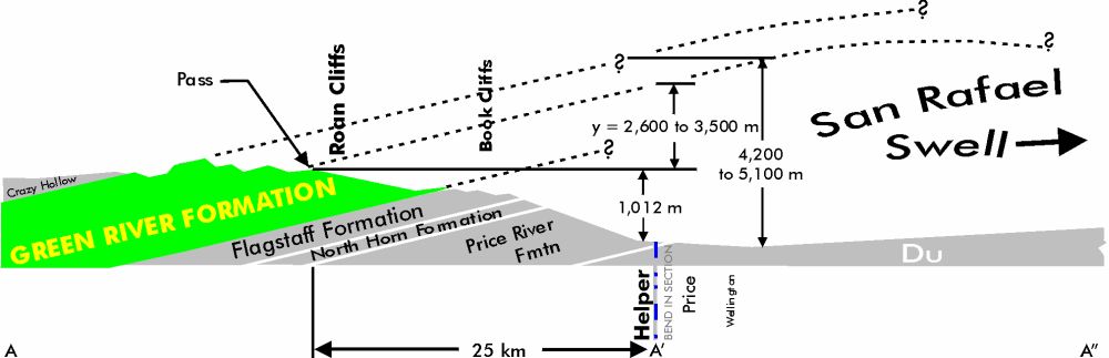
In chapter 4 of Part II, Brown greatly amplifies his model on the origin of Grand Canyon. Brown starts with two ponded lakes left over from the Genesis Flood: one northeast and one southeast of Grand Canyon, called Grand Lake and Hopi Lake, respectively.12 In Brown’s model, the lakes start near sea level right after the Flood and rise about 1,800 m (6,000 ft) along with the Colorado Plateau, as the very high Rocky Mountains sank a considerable distance. This great differential vertical tectonics also caused huge east-west block faults, for instance at the Roan and Book Cliffs in the northern Colorado Plateau (figure 3) and the Grand Staircase just north of Grand Canyon (figure 4). Then after several hundred years, Grand Lake burst also causing Hopi Lake to break. The combined volume of both lakes first erodes a 300 m (1,000 ft) thick layer of soft sediments capped by hard rocks over an area of 26,000 km2 (10,000 mi2) all around Grand Canyon, leaving behind a generally flat planation surface (figure 5) with several 300 m (1,000 ft) high erosional remnants, such as Red Butte (figure 6). Then the water channelized and carved Grand Canyon, excavating 3,280 km3 (800 mi3) of rock. Side canyons were carved by a huge amount of ground water released toward the canyon. In the former lake bed of Grand Lake, upward pressure of ground water released after the lake burst and caused vertical walled buttes and spires. Also in the bed of Grand Lake, thick sediments were deposited in the area of the Goosenecks and then over many years of subsurface water leakage, the huge ancient San Juan River carved the Goosenecks (figure 7). The rushing water of Lake Hopi caused a large number of floating logs to ground creating the petrified logs of Petrified Forest National Park. Brown ends this chapter with a typical comparison table in which his model is rated vastly superior to the many uniformitarian ideas put forth by Powell, Gilbert, Emmons, Blackwelder, McKee, Hunt, Lucchitta, and Meek/Douglas.


The fifth chapter is on the origin of limestone and dolomite, a challenge for any Flood model, and includes very brief sections on limestone and silica cement that bind sediments into sedimentary rocks. He believes limestone was dissolved in the underground chambers before the Flood and came rushing out with sediments during the rupture phase. The limestone separated into thick widespread deposits during liquefaction. Limestone and dolomite are inorganic precipitates. The organisms in the limestone are from post-Flood time during limestone precipitation, which also added the CO2 for rapid forest growth on the post-Flood Earth. His model also explains the origin of caves and their deposits. He also claims that the chalk in England and France is inorganic, referencing an article by the geologist Tarr in 1925. A high amount of dissolved limestone in the oceans after the Flood enhanced coral growth. He briefly mentions silica cement and suggests that petrified trees (from silica) formed by floating in post-Flood lakes high in silica. He ends the chapter stating that limestone should be found in meteorites because they came from the earth, and that most traces of the limestone disappeared due to mishandling in the laboratory.


In chapter 6, Brown summarizes his hypothesis on the extinction of the woolly mammoths in Siberia and Alaska, emphasizing the frozen carcasses. There are many mysteries to be explained. He has an excellent map with an accompanying table showing the locations of the 58 frozen carcasses that have been discovered up until 1999. In his model, water that jets above the atmosphere in the first hours of the Flood freezes and falls back to earth as muddy hail with a temperature below –90°C (–150°F). The mammoths are frozen almost instantly. It is unclear whether this muddy hailstorm occurred everywhere or was scattered across the Earth. Brown believes the mammoths actually lived in a temperate climate before the Flood at low to mid latitudes, and as the mountains uplifted during the great hydroplate crunch, the earth rolled 35 to 45° placing the frozen mammoths northward into Arctic latitudes, where they remained frozen to this day in the permafrost. The mammoths are found in hills called yedomas composed of muck, which Brown considers a mysterious sediment, that contains a large amount of ‘rock ice’, organic matter, and plant material in disarray.
Chapter 7 presents a unique hypothesis on the origin of comets. Comets result from the coagulation of mud and water that was launched into space from the jetting water at the beginning of the Flood. He offers as evidence organic molecules, water, deuterium (hydrogen with an extra neutron), olivine, and other molecules in comets that would imply that the material of comets came from the Earth. Also comets from Earth explain the frozen water on the Moon, in the craters of Mercury, and the floods of Mars.
The origin of asteroids and meteoroids is the subject of Brown’s last chapter, chapter 8, of Part II. As with comets, he says all asteroids and meteoroids were formed during the jetting phase as rocks, particles, and water were ejected into the solar system during the rupture phase. His main reason for postulating this unique hypothesis is because asteroids have Earth-like features, and so Brown concludes that they must have originated from the earth. The rocks injected into space came mostly from the pillars that held up the granite crust within the underground chamber of water before the Flood (figure 1). These pillars underwent special mineral transformations that explain the composition of meteoroids, such as the iron/nickel meteorites. Smaller rocks jetted into space coagulated and were stuck together by ice to form the larger asteroids. Drag forces caused by water vapor and thrust forces produced a radiometer effect13 that concentrated asteroids in the asteroid belt. Some asteroids became the small moons of some of the planets. Oxygen contained in the water vapor also explains the reddish dust on Mars, while asteroids and comets caused the floods on Mars.
A future chapter 9 of Part II, The Origin of Earth’s Radioactivity, can be assessed online at his website. Brown states that as the Flood began, stresses in the massive fluttering crust generated huge voltages via the piezoelectric effect. Fluttering is caused when a fluid flows over a relatively thin, solid surface, such as wind passing a stationary flag. As the water surged out of Brown’s underground chamber, the granite crust fluttered up and down, forming waves. The downward portion of the granite crustal wave would have thumped the basalt lower crust creating ‘water hammers’ and enormous pressure. Equally powerful magnetic forces squeezed atomic nuclei together into highly unstable, superheavy elements that quickly split and decayed into subatomic particles and various isotopes, some of which became radioactive. That is how radioactive elements developed in the Earth. Moreover, accelerating radioactive decay also occurred. The vast amount of energy produced was used to launch meteoroids and the material that eventually became asteroids and comets.
General comments
Brown’s hydroplate model purports to explain an enormous number of observations and past events. It seems fantastic that one model with one assumption and the laws of physics can explain so much. But there is an old saying that “if it’s too good to be true, it probably is.” I find much of Brown’s model and many of his explanations of phenomena lacking detailed evidence. Sometimes aspects of his model are unclear or incomplete, leading to difficulty understanding some of it. For instance, I was unsure of whether the muddy hail that fell from space froze only the woolly mammoths and other animals that are now found at high latitudes.
The initial condition
One of the first problems is his initial configuration of the pre-Flood Earth and the condition of his subterranean chamber increasing in temperature and pressure with time due to tidal pumping. This is a very special, arbitrary initial condition that has no evidence, as far as I know. It also raises the question of whether God would have created a world that He called ‘very good’ which already had a ‘ticking time bomb’ which, in time, will explode. It also seems to me that he does not have only one assumption in his model, as claimed, but seems to make further assumptions continually in order to make his model fit the observations of rocks, fossils, and the solar system.
Lack of in-depth analysis
Brown’s book has much good information and brings up many conundrums of earth science. These include the fact that the fit of the continents across the Atlantic Ocean is not as good as most people believe. In the famous Bullard fit, Africa had to be shrunk 35%; Central America, southern Mexico, and the Caribbean Islands had to be removed; the Mediterranean Sea was reduced in size; Europe was rotated counterclockwise; Africa rotated clockwise; and North America and South America were rotated relative to each other.14
Although he has seven chapters amplifying aspects of his Flood model, Brown does not analyze many phenomena in depth. Instead he gives a broad brush analysis without connecting details of his mechanism with the phenomena to be explained. Examples will be given in the section on specific comments. He also does not subject the steps in his model to peer review and publication in the creationist technical literature, although he did publish a broad brush of his model at the International Conference on Creationism15 and in the Creation Research Society Quarterly.16 Each step in his model should have been justified by peer review and publication.
For instance, he points out that some atolls in the central Pacific, such as Eniwetok Atoll, have a thick carbonate cap, but because of insufficient analysis does not realize that many of the surrounding guyots, which he calls tablemounts, in the region of atolls also have a thick carbonate cap: “The depths of tablemounts below sea level increased rapidly; otherwise most would have coral growths rising near sea level.”17 He also thinks that the carbonate cap on Eniwetok (and presumably other atolls) is a reef, composed of corals almost a mile deep: “Eniwetok Atoll, composed of corals, lies in the tablemount region and rests on a tablemount.”16 There is much evidence that the carbonate on Eniwetok and other atolls is not from a reef,18 showing Brown’s incomplete analysis of reefs.
Fitting his model to the data
He often seems to make his model fit the data. For instance, he says that the basaltic, pre-Flood lower crust was eroded by strong horizontal currents in the subterranean chamber, adding 35% of the particles to the Flood sediments with the other 65% of the particles coming from the crushed granite. This just happens to match estimates made of the particles in sedimentary rocks by Mead in 1914 and Twenhofel in 1961.
Questionable references
Brown seems to rely on legends and myths too much, for instance a Hopi Indian legend claiming that the mid-ocean ridge in the Pacific was once above sea level,19 which supports his idea that sea level was at least 4.6 km (2.9 mi) lower than today after the Flood. To support his idea of an Earth roll, he sometimes uses questionable sources, such as Charles Berlitz, who wrote on tribal mythology, psychic studies, ancient astronauts, and archeology, but is most well known for perpetrating the massive Roswell aliens hoax in his coauthored book, The Roswell Incident.20
Questionable analogies
I find that he uses analogies a lot, but some give the wrong impression because they do not compare well with the phenomenon to be explained, for instance in the following:
As the continental plates met resistance, they crashed (or quickly decelerated), crushed, and thickened, similar to a thick sheet of snow sliding down a mountainside in an avalanche.”16
Thickening snow as an avalanche comes to a stop is an easily understood phenomenon, but the analogy makes one think that granite can easily pile up upon deceleration of hydroplates. So, the analogy does not apply except in a superficial sense. The question really is, “What should we expect if granite hydroplates came to an abrupt halt?” and “Is there evidence for this?” which should be abundant. Finding isolated chevron folds in the Rocky Mountains21 or dikes in Black Canyon and the inner gorge of Grand Canyon22 are not significant evidence for the halting of granite hydroplates.
Brown also uses the analogy of a buckling upward spring as an analogy of the Mid-Atlantic Ridge buckling up nearly 16 km (10 mi).23 But the analogy only applies in the most superficial sense. The analogy is misleading in that one gets the impression that the buckling upward of the MAR is quite easy.
Predictions
Brown makes a number of predictions for his model, which are summarized in Part III in Frequently Asked Questions.24 Some are bold, like a prediction should be, such as prediction 6: “A 10-mile-thick granite layer (a hydroplate) will be found a few miles under the Pacific floor and inside the ring of fire and others.”25 Other predictions seem insignificant, such as prediction 10:
“Corings taken anywhere in the bottom of any large lake will not show laminations as thin, parallel, and extensive as the varves of the 42,000-square-mile Green River Formation, perhaps the world’s best known varve region.”26
The Green River ‘varves’ are especially thin and widespread, very likely formed during the Flood12, while post-Flood lake rhythmites (not necessarily varves that are defined as rhythmites with couplets of one-year duration) are not expected to be the same because of the different mechanism and environments of formation.
He claims to have confirmed four out of 39 predictions: (1) pooled water under mountains, (2) hidden canyon under the Bosporus, (3) salt on Mars, and (4) carbon-14 in ‘old’ bones. I am uncertain how significant these ‘hits’ are, but from a creationist point of view we would predict carbon-14 in a lot of ‘old’ material.
Questionable comparison tables
I found his comparison tables artificial in that he compares his model to poor or old uniformitarian and catastrophic hypotheses. Since my ideas on the life and death of the woolly mammoths in Siberia, Alaska, and the Yukon Territory of Canada were compared in his chapter on woolly mammoths, I will have more to say about comparison tables in the section on the woolly mammoths.
Specific comments
I will give only a few specific comments on Brown’s model outlined above, and delve deeper into the subjects I know best, which are: (1) the origin of Grand Canyon, and (2) the life and death of the woolly mammoth. His two chapters on this subject are examples of what can be said about his other chapters after an in-depth analysis of other aspects of Brown’s model and the phenomena that he purports to explain.
The HPT mechanism
Probably a whole book could be written on every aspect of the HPT mechanism. Much more details are needed to fill in the many gaps. For instance, would a quantitative analysis of pre-Flood tidal pumping heat the subterranean water chamber enough to cause it to burst? And why would it burst in a linear fashion along the MORs and not through one or several openings through the upper granite crust, as one would expect: It seems that if one heats a bottle full of water, the bottle will burst at one locality.
I especially question that there would have been sufficient force for the jets of water to do what they are claimed to have done. Namely, to break through the MOR, jet through the atmosphere, and shoot water and rocks into outer space to form meteoroids, asteroids, and comets, plus put these solar system bodies into precise orbits. The mechanisms of ‘fluttering’ and ‘water hammers’ seem much too weak to overcome the Earth’s gravity. A lot of quantitative calculations are required to show the sufficiency of the ‘rupture phase’.
Creationist astronomer Danny Faulkner has done several back-of-the-envelope calculations in examining Brown’s ideas on comets and asteroids. He finds numerous problems. For instance, passing enough water and solids up through the atmosphere at Mach 150 is not possible.27 Furthermore, he shows that long-period comets do not have enough time since the Flood to return close to the Earth in order to be detected, so we should not have seen any long-period comets yet. Faulkner also questions Brown’s claim that the composition of comets means they had to have come from the Earth. He finds errors in many other of Brown’s assertions in regard to astronomical data, and concludes that the hydroplate model cannot explain the origin of comets and asteroids.
The mechanism to produce the Flood sediments starts with the crushing of the rock around the MORs and the erosion of the basaltic lower crust below the water chamber. Then the sediments in just the right proportions of 35% basalt and 65% granite are spread over the hydroplates by water. But the hydroplates are shallow compared to the Pacific Ocean that is buckling downward. One wonders whether the sediments would end up in the Pacific Ocean, especially considering the relative high velocity of the hydroplates. More details of sedimentation would be nice.
His mechanisms for the formation of salt and carbonates are similarly too good to be true. Why should carbonates and salt act differently, as he describes? How does gypsum, a major precipitate often found with salt layers, fit into his model? The thick and widespread salt deposits in the Gulf of Mexico and adjacent coastal areas are much more than 640 km (400 mi) from the Mid-Atlantic Ridge. So, the salt in the subterranean water chamber would not be exposed for sediments to pile on top of, unless the deposits formed after the continental drift phase. Chalk has been demonstrated to be organic, made up of coccoliths, a marine microfossil.
The whole idea of liquefaction to sort sediments and fossils must be demonstrated to be workable on any scale other than very local. How could such liquefaction sort on a worldwide scale? It seems that liquefaction would tend to mix sediments instead of separating different types of sediments such as carbonates, muds, sand, silt, clay, etc., as well as the types of fossils seen in the geological column. There are also no details of how liquefaction can produce the phenomena that it purports to explain.
The continental drift phase needs much filling in of detail. Is the removal of 10 miles (16 km) of granite at the MORs sufficient to cause the basalt lower crust to rise up almost that distance? And given the tremendous horizontal distances, would the granite upper crust slide away from the Mid-Atlantic Ridge to where we see the continents today? Then there is the issue of what happened at other MORs; it seems that the same rise should have happened on the East Pacific Rise, the ridges in the Indian Ocean, and others, which would mess with the formation of trenches that are mostly around the Pacific Ocean. Then how could such buckling upward of the Mid-Atlantic Ridge cause a sucking in of the Pacific plate forming trenches and the ring of fire on the edges? Much more evidence is demanded on how the Earth’s outer core could liquefy, and that magnetite could sink and align in the solid inner core to form the magnetic field and change the length of the day. (The Earth’s magnetic field and its decay are understood quite well as the result of a circulating current in the liquid outer core).
The evidence for the compression event is minuscule in the form of isolated chevron folds and dikes in the Rocky Mountains, while such features should be widespread. The rise of the mountains to perhaps twice their current height needs to be demonstrated, and most especially that such a rise can cause a roll of the planet of up to 45°. Quantitative details are absent. He attempts to explain warm climate fossils in high northern latitudes, but what about the warm climate vegetation, coal, and dinosaur fossils on Antarctica?
His ideas on the formation of radioactive elements equally suffer from a lack of quantitative evidence. Furthermore, Brown’s mechanism of fluttering or waving of upper granite crust and water hammers seems orders of magnitude insufficient to cause radioactive elements.
Is Brown’s version of the dam-breach hypothesis for Grand Canyon viable?
Brown’s motivation for postulating his dam-breach hypothesis is mainly because he sees the Flood as inadequate for the job of carving Grand Canyon. He believes that if the Flood drained from all over the earth, there should be hundreds of other Grand Canyons,28 and the Flood water could not rise 1,830 m (6,000 ft) to flood the Colorado Plateau.29 I am sure he feels that the Flood is inadequate to explain many other geological features. It is dangerous to conclude that the Flood could not produce a particular feature carved by water in the past, especially since we have extremely few facts in geology and paleontology to work with and we are not nearly smart enough to put the known facts together. It takes great long-term, in-depth analysis to produce a hypothesis for the Flood origin of any feature, and even then we are rarely privy to all the information in order to make an informed decision.
I do not think Brown has thought through his Flood objections very well. The depth of an erosional canyon during channelized Flood runoff will depend upon many variables, including the amount of water being channelized, the velocity of flow, the type of rock eroded, the intensity of the uplift of the land, and the amount of sinking of the continental margin. In the case of Grand Canyon in a model of Flood runoff, flow converged at the location of eastern Grand Canyon from drainage of the entire Colorado Plateau.30 With the strong rise of the Colorado Plateau and the sinking of the continental margin off California, a deep canyon would be expected. Brown should have worked out the details of his assertion and published it in the creationist technical literature. Besides, there are many other deep canyons across the earth, such as Copper Canyon in the Sierra Madre Occidental Mountains of northwest Mexico, which is deeper than Grand Canyon and only 965 km (600 mi) south.31,32
As far as the impossibility of the Flood water covering the Colorado Plateau, Psalm 104:6–9 indicates that the land rose up out of the Flood water.33 This is similar to the canard that the Flood water could not cover Mount Everest. However, the Himalayas and all the mountains of the world rose up out of the Flood water.34 In fact after deposition, of the thick sediments on the Colorado Plateau, an average of 2,500 to 5,000 m (8,500 to 16,500 ft) of sediments and sedimentary rocks was eroded, based on eroded anticlines.12,35 How would this happen after the Flood?
Brown’s dam-breach hypothesis has numerous problems, as do all dam-breach hypotheses.36 One major problem is he needs to erode around 3,000 m (10,000 ft) of strata from the whole Grand Canyon area because that is the approximate amount that once lay over the area based on the dipping strata of the Grand Staircase (figure 4). Such erosion occurred in the late Cenozoic because of the Marysvale Volcanics on top of the fifth stair that once extended far south and dated as late as early Miocene.37
In regard to the Grand Staircase, as well as the Roan and Book Cliffs, Brown states that these are east-west faulted escarpments and so he does not need to erode 3,000 m (10,000 ft) of strata but only 300 m (1,000 ft) over an area of 25,500 km2 (10,000 mi2). Brown stated:
“Large blocks, when lifted, became cliffs and block-faulted mountains. North of the Grand Canyon are many examples: Utah’s Book Cliffs, Roan Cliffs, the Grand Staircase (Vermillion Cliffs, White Cliffs, Grey Cliffs, Pink cliffs), and many others.”38
However, these cliffs are obviously erosional escarpments, especially seen at contacts between strata in north-south valleys that penetrate the ‘stairs.’ They are not fault scarps. The major faults in the region are orientated north-south.
Not enough water for erosion
Let us for sake of discussion assume that he needs to erode only 300 m (1,000 ft) of soft strata. One problem is that this soft strata had a hard cap of rock on top, as shown by three erosional remnants in the Grand Canyon area: Red Butte (figure 6), Cedar Mountain, and Shinumo Altar. Regardless, the total volume of rock eroded by sheet flow would be 8,500 km3 (2,000 mi3). The volume of Brown’s two lakes east of Grand Canyon was only about 12,000 km3 (2,930 mi3). That is a little more than a cubic km of water to erode a cubic km of sediment, which seems like too little water, just to erode the 300 m (1,000 ft) of sediments before Grand Canyon was even carved!
Furthermore, all the water would have to be available all at once. When a lake breaks through hard rock, it slowly lowers the outlet, such as happened during the Bonneville flood, when pluvial Lake Bonneville overtopped Red Rock Pass in extreme southeast Idaho. It is estimated that about 100 m (330 ft) of rock was eroded in about 8 weeks before the flood ended. Although a uniformitarian estimate, I believe it because the flood landforms in the Snake River Valley of southern Idaho are quite small, especially compared to huge flood landforms in eastern Washington caused by the Lake Missoula flood. In the latter flood, a large percentage of the 2,200 km3 (540 mi3) of water in glacial Lake Missoula was available all at once because of the breaking of the ice dam. In fact, that much water only eroded about 200 km3 (50 mi3) of soft silt and hard basalt along the flood path. That is about a 10 to 1 ratio of water to erosion with water velocities locally around 96 km/h (60 mph), which again shows that the volumes of Brown’s Grand and Hope Lakes are much too low to erode so much rock over northern Arizona, before about 3,500 km3 (800 mi3) of rock was eroded to form Grand Canyon. If Brown is hoping to add a substantial amount of released ground water, see the discussion below on ground water supposedly carving tributary canyons and other features of the southwest Colorado Plateau.
The lakes did not breach at the low points
Lakes breach at low points along their edge, such as what happened during the Bonneville flood. In all the versions of the dam-breach hypothesis, the breaching that carved Grand Canyon breached the south-sloping Kaibab Plateau at about 2,500 m (8,000 ft) on the North Rim and 2,200 m (7,000 ft) on the South Rim. However, the lowest points of the Kaibab Plateau are about 1,750 m (5,750 ft) on the northern end and 1,920 m (6,300 ft) on the south end of the Kaibab Plateau. Why didn’t the lake breach occur at these low points?

Austin has suggested that piping, water flow through cracks or tunnels in the rock, caused the initial breach through solid rock.38 However, the Redwall Limestone, which has a few caves, would have been many hundreds of meters below the bottom or edges of the lakes and the piping would have to extend over 160 km (100 mi) to the west.
Fatal problem no. 1: no evidence for the lakes
There are numerous other problems with any dam-breach hypothesis, but two really stand out and seem fatal to the hypothesis.35 The first is the lack of evidence for the two lakes. There are no lake bottom sediments, no shorelines, and no raised deltas where streams would have entered the lakes, while pluvial lakes of the nearby Great Basin and the ephemeral glacial Lake Missoula have abundant bottom sediments, shorelines, and raised deltas.
Sedimentation of lakes occurs along stream or river deltas and along the bottom by the sinking of fine particles, as well as downslope flow of turbidity currents and debris flows. The sediments are relatively soft around the putative lakes east of Grand Canyon, so there should have been thick sediments on the bottom of the lakes, but there are none. The Bidahochi Formation has been considered by a few creationists to be bottom sediments of ‘Lake Hopi’,39 but these sediments and sedimentary rocks are practically all volcanic or laid down by moving water.40,41 Besides, the Bidahochi Formation is currently near the top of, and even above, the lake surface of ‘Lake Hopi’. Any thick bottom sediments could not have been scoured out during the dam breach because the outlet of ‘Lake Hopi’ is a narrow slot canyon (figure 8) and so could not pass enough water fast enough to cause significant bottom-eroding currents in the greater part of the large ‘Lake Hopi’ (figure 9).
Brown has suggested reasons why there should be no shorelines,42 but these do not stand up to scrutiny.35 He first stated that after the Flood, the Colorado Plateau rose more than 1.6 km (1 mi), while the Rocky Mountains sank. Such uplift of the Colorado Plateau altered the shapes of the basins and caused the shorelines to shift. This shifting caused the water level also to shift so that it would not be at any one location long enough to etch a shoreline. Pluvial Lake Bonneville was just west of the proposed lakes and has abundant large shorelines. So, why wouldn’t Lake Bonneville also be affected by such great vertical uplift? Besides being a very unlikely scenario, such tectonic instability would not have been conducive to lake formation nor for long-term maintenance—the lakes should have lost their water much earlier than the dam-breach hypothesis predicts.

Brown suggested that oscillations in the lake waters would further erode any shoreline features, but these same movements would have caused the lakes to overflow their natural rock barriers, or render them mechanically unstable. Also, there is no field evidence of such dramatic crustal motions or of such lake oscillations at nearby pluvial Lake Bonneville to the west, which should have been affected by such tectonic instability, being so close to the lakes on the Colorado Plateau. Furthermore, Brown admits that the volume of Grand and Hopi Lakes would have increased rapidly after the Flood, which means that the lakes would have been even more unstable and very likely to have sloshed over their lowest rim and breached too early.
Brown secondly suggested that Lakes Bonneville and Missoula probably breached centuries after Grand and Hopi Lakes. Therefore, thunderstorms would have more time to erode the shorelines of the latter lakes. However, this deduction suffers from incomplete analysis. Grand and Hopi Lakes likely lasted 200 to 500 years. On the other hand, glacial Lake Missoula probably broke about 500 years after the Flood, after filling for about 80 years with each year’s stillstand forming a shoreline.43 It must have taken less than a year to etch each shoreline of glacial Lake Missoula, all the lower shorelines were then protected under the water and were able to be preserved.
Pluvial Lake Bonneville rose throughout this time and broke through Red Rock Pass a little before the Lake Missoula flood44, since the deposits of the Bonneville flood are below those of the Lake Missoula flood around Lewiston, Idaho. Lake Bonneville dropped over 100 m (330 ft) during the Bonneville flood. The highest and second highest shorelines are very distinct. So, the highest shoreline of Lake Bonneville must have been made within 500 years of the Genesis Flood, and since the lake was rising to that level in that time, the shoreline was made in much less time. It does not take long to make a shoreline, which means that shorelines should be abundant at many levels of the former basins of ‘Grand and Hopi Lakes’.
Although Brown cited erosion of shorelines by frequent summer thunderstorms, he cannot explain why that erosion is not observed affecting other preserved features across the Western United States, such as the abundant shorelines associated with the pluvial lakes. Moreover, shorelines cut into slopes would be more protected from the worst erosion, which comes from water accumulating in lower areas and flooding down gradient. Moreover, climatic conditions in Montana are just as, if not more, conducive to erosion by heavy snow runoff and summer thunderstorms, yet the remnants of glacial Lake Missoula are still plainly there.
Brown also appealed to elevated groundwater flow after the lakes emptied to destroy the shorelines. He believes that powerful springs would be so pressurized that shorelines would not only be destroyed, but cliffs formed from groundwater shooting high into the air. Such a scenario seems impossible, or at the least impossible to substantiate. But the shorelines of Grand and Hopi Lakes, if they existed, would often be found at high altitudes once the lake emptied. The shorelines probably would also be well above the water table. This would make it tough for groundwater discharge, as proposed by Brown, to reach such altitudes. Therefore, shorelines at higher altitudes should be preserved.
Brown did not utilize this argument, but it is possible to claim that shorelines would more easily erode on the Colorado Plateau because the sedimentary rocks are less consolidated. The problem with this is that glacial Lake Missoula’s shorelines are preserved on both hard and soft rock.45 Furthermore, many of the rocks beneath the proposed lakes on the Colorado Plateau are consolidated; certainly hard enough to preserve shorelines from minimal erosion over 4,000 years.
Fatal problem no. 2: long tributary canyons

There are three long tributary canyons that start far from Grand Canyon and descend down to the level of Grand Canyon (figure 10). These are Kanab canyon, about 80 km (50 mi) long, Havasu Canyon, about 97 km (60 mi) long, and Peach Springs Canyon, about 32 km (20 mi) long. The canyon of the Little Colorado River does not count in this analysis since it is proposed to have been carved by the breaching of ‘Lake Hopi’. The first two enter the Grand Canyon in 1.6 km (1 mi) deep slot canyons.
These canyons, not fault related, had to form at the same time as Grand Canyon so water from the dam-breach had to start in the headwaters of those canyons, suggesting that the waters of the dam-breach were at least 180 km (110 mi) wide. Brown’s version of the dam-breach hypotheses possibly could account for Kanab Canyon after the supposed sheet erosion of the 300 meters (1,000 ft) of strata over northwest Arizona. However, it would have been extremely difficult to erode Havasu and Peach Springs Canyon which enter Grand Canyon from the south.
Brown attempts to explain the erosion of these tributary canyons, plus add more water to erode Grand Canyon, by the catastrophic flow of a huge amount of ground water trapped within the sediments after the Flood. The problem with this ad hoc idea is that ground water cannot rush out of the sediments fast enough to cause significant surface flow and erosion. Furthermore, the sediments were consolidated and so water would move slowly through the pores of mainly the sandstones and possibly through caves in the limestone. The evidence for consolidation of the sediments at the time of the dam breach is the sides of Grand Canyon and side canyons, which would have slumped or bowed into the canyon if unconsolidated. The vertical walls of all the canyons provide direct evidence that the rocks were consolidated when Grand Canyon and its tributaries formed.
Discussion
There are numerous problems with the dam-breach hypotheses for the origin of Grand Canyon, as listed in Table 1. Two of these problems, the lack of evidence for lakes and the existence of long, deep tributary canyons, seem fatal to the hypothesis. There are many more specific problems that can be brought forth against Brown’s version of the dam-breach hypothesis, but the above are enough to show that his hypothesis won’t work.
A much better hypothesis for the origin of Grand Canyon is late Flood channelized erosion. The Grand Canyon is essentially a long water gap and so must be explained within the field of geomorphology in regard to the origin of water gaps.31 There are thousands of water gaps across the earth, 1,700 in the Appalachian Mountains of the eastern United States alone. These water gaps can easily be explained by channelized runoff of the Flood water flowing perpendicular to a barrier and channelizing.32 The 3,000 m thick layers of sedimentary rock removed from the Grand Canyon area, called the Great Denudation by uniformitarian geologists, can be explained by wide currents flowing from west to east early in the Recessive Stage of the Flood (the direction of flow shown by paleocurrent directional indicates in the lag Rim Gravel).46 Then the southern Rocky Mountains uplifted and the Flood current turned 180° toward the west and channelized in what uniformitarian geologists call the Great Erosion. This is when Grand Canyon formed.29
| No evidence for the lakes (no shorelines, raised deltas, or bottom sediments) |
| Long, deep, narrow tributary canyons (Kanab and Havasu Canyons) |
| Rapid rise of lake water after the Flood would have caused a dam breach at the low points |
| Piping unlikely |
| A simultaneous release of most of the water required |
| Not enough water for sheet erosion or channelized erosion |
| Large crustal uplift and block faulting not supported by field evidence |
| Lack of flood features, such as bars and slackwater rhythmites, as seen with Lake Missoula flood |
| Lack of a massive gravel bar at the mouth of Grand Canyon |
Table 1. Summary of evidences against the dam-breach hypothesis for the origin of Grand Canyon, the first two of which are judged to be fatal to the hypothesis.
Were woolly mammoths quick frozen early in the Flood?
I find numerous problems with Brown’s hypotheses for the woolly mammoths in Siberia, Alaska, and the Yukon Territory. I only have space to deal with the major issues. The first one is the timing of the mammoth material: did they die very early in the Flood or at the end of the post-Flood Ice Age?
Evidence the woolly mammoths died during the ice age
Undoubtedly many different elephant types existed before the Flood, likely including various mammoths and mastodons, and so I would expect to find elephant fossils buried by the Flood. However, the bones and tusks of woolly mammoths under consideration are found in the surficial sediments all across the mid and high latitudes of the Northern Hemisphere, not just in the far north. In many of these areas, they are found in post-Flood contexts, such as tar pits, river terraces, glacial till, and local flood sediments. In the higher latitudes the woolly mammoths, as well as other mammals, are found in the permafrost, permanently frozen sediments. So, why should Brown separate the two groups, the ones in the far north very early in the Flood and those in the mid latitudes from the Ice Age? Furthermore, they are also found in caves on St Paul Island of Alaska47 and on top of glacial till in northwest Siberia48, which are all clear post-Flood contexts at high latitudes.
If buried early in the Flood, they should be buried near the bottom of the sedimentary layers. But, a huge number of woolly mammoth remains lie in the surficial permafrost of the New Siberian Islands on top of thick sedimentary rocks that include carbonates, marine fossils, and coal.49 In Brown’s prediction No 20, he states: “One should not find marine fossils, layered strata, oil, coal seams, or limestone directly beneath undisturbed rock ice or frozen mammoth carcasses.”50 Although this seems like a good prediction, Brown really means that woolly mammoth carcasses will not be directly above marine fossils, layered strata, oil, coal seams, or limestone. The prediction likely fails in the New Siberian Islands, but it would be difficult to prove since one would have to drill below the few carcasses found (the vast majority of woolly mammoths are bones and tusks) on the islands. Given the widespread, thick sedimentary rocks below the surface of the New Siberian Islands, the few carcasses would have to be on top of igneous or metamorphic rocks to fulfill the prediction.

Further evidence that the mammoths were associated with the post-Flood Ice Age is that they are rarely found in the central and northern portions of areas covered by the continental ice sheets during the Ice Age (the exceptions can be explained within the post-Flood Ice Age model). Figure 11 shows the distribution of woolly mammoths in the Northern Hemisphere. This suggests that the ice prevented woolly mammoths from colonizing those areas because of the existence of ice sheets. Otherwise, if the woolly mammoths were buried early in the Flood, there should also be an abundance of woolly mammoth remains in post-Flood glaciated areas as well.
Further problems with the quick freeze idea
Although the quick freeze idea in which mild temperatures suddenly fall to below –90°C (–150°F) is a reasonable idea that was suggested almost 200 years ago by George Cuvier, it has a few problems. Brown postulates that the woolly mammoths lived before the Flood in a temperate climate at mid latitudes and were quick-frozen in extremely cold muddy hail very early in the Flood. Then later in the Flood, when the mountains uplifted in his great plate crunch, the earth rolled 35 to 45°, sending the frozen woolly mammoths northward to high latitudes where we find them today. Besides grave doubts on the possibility of such an Earth roll, the details of which have not been worked out, one would expect to see a huge number of woolly mammoth and other animal carcasses in the far north. However, the number of carcasses, defined by any scrap of flesh, is less than 100. Brown even has an excellent map of their locations, and as of 1999, there are only 58 of them.51 The tens of thousands of woolly mammoths discovered so far are practically all bones and tusks, indicating a time for decay of the flesh.
A second piece of evidence against the quick freeze is that the carcasses have been partially decayed.52
Third, fly pupae are associated with the bones and carcasses, showing that flies were able to lay eggs and maggots to be hatched, which would take some time.51
Fourth, signs of scavenging occur on some carcasses, such as Blue Babe which Dale Guthrie of the University of Alaska at Fairbanks has analyzed.53
Fifth, when the vegetation of their stomachs is analyzed, it indicates different seasons of death.54,55 In a quick freeze, death is instant and the stomach contents should record one season of death.
And lastly, since half-digested stomach contents is said to be evidence for a quick freeze, partially decayed vegetation is found in the stomach and intestines of mastodons found in unfrozen peat, the remains of old bogs, in the northeast and north-central United States.56 Thus, the state of preservation of the vegetation could be caused by the low amount of bacteria in a cold environment and the fact that elephants digest their food after the stomach, which serves as a large storage pouch in which the vegetation is partially broken down by acids and enzymes.57,58 Table 2 summarizes the evidence against a quick freeze of the woolly mammoths early in the Flood.
| Part of a Northern Hemisphere Ice Age steppe (grassland) community |
| Found in surficial sediments, not at the bottom of thick sedimentary rocks |
| Found in a cave on St Paul Island in the Bering Sea (cave wall is of Flood origin) |
| Found on top of glacial till northwest Siberia |
| Rarely found within central and northern areas that were glaciated during the Ice Age |
| Carcasses rare, while they should be abundant if quick frozen and buried by muddy hail (bones and tusks abundant) |
| Carcasses partially decayed with fly pupae in both carcasses and the bones |
| Some carcasses scavenged |
| Stomach vegetation indicates different seasons of death |
| Half-decayed vegetation also found in US mastodons of the Ice Age |
Table 2. Summary of the evidences against Brown’s hypothesis that the woolly mammoths in the high latitudes of the Northern Hemisphere died early in the Flood by a quick freeze.
An ice age model for the life and death of the woolly mammoth
After adding up as many facts as available, I have determined the evidence shows the woolly mammoths lived and died during the Ice Age.59 To make a long story short, the woolly mammoth population increased rapidly to millions in the first few hundred years after the Flood. Early in the Ice Age, Siberia had very mild winters and cool summers with heavy precipitation caused by warm onshore flow of mild, moist air from the Arctic and North Pacific Oceans. Forests must have grown in the unglaciated lowlands of Siberia early in the Ice Age. By the middle of the Ice Age, the area had dried enough for a grassland to be widespread, as part of the great Northern Hemisphere Mammoth Steppe.60 Millions of woolly mammoths and many other mammals spread into Siberia, Alaska, and the Yukon. But at the end of the Ice Age, winters became much colder than today as summers warmed. The ice sheets and mountain ice caps melted, the Arctic Ocean froze over with sea ice developing far south in the North Pacific and Atlantic Oceans. Dry, cold, windy storms were typical, causing monstrous dust storms. The woolly mammoths were buried in loess (wind-blown silt), commonly found up to 60 m (200 ft) thick in the lowlands of Siberia and Alaska. The slumping of this loess in hilly or mountain terrain mixed trees, vegetation, and animals remains, which has been called muck by gold miners and is not a mysterious substance. When the permafrost formed, abundant ice lenses and wedges formed, which is also not mysterious. The wind-blown silt is able to explain many of the mysteries associated with the woolly mammoths, such as the well-preserved nature of bones, tusks, and carcasses, how they were entombed in permafrost, why some are in a general standing position, why some suffocated, and why some animals have broken bones.
Artificial comparison table
Since Brown compared my hypothesis with his, along with the poor uniformitarian and non-creationist catastrophist ideas in his Table 12,61 it gives me a chance to evaluate his comparison table, which should be indicative of other comparison tables that always portray Brown’s model as vastly superior, although he does admit the subjective nature of these tables. I will only compare a few of the categories. Taking number one, the abundance of food, Brown scores himself high and me low. But Brown explains the abundant food as originating at mid latitudes where the woolly mammoths were living at the time in a warm climate. Then the earth rolled 35 to 45° north to place the frozen carcasses at high latitude. This is massive conjecture, or one could say special pleading, especially when there is no physical evidence to support such a claim. So, without demonstrating the feasibility of such a poleward shift, which seems impossible by his mountain uplift mechanism, he scores high because of the greater abundance of food in the mid latitudes. I would conclude that this high score is artificial and actually depends upon him first demonstrating the feasibility of such a roll. I would explain the abundance of food from the mid Ice Age drying of Siberia caused by cooler sea surface temperatures, less evaporation, and downslope foehn winds off the ice sheet to the west. So, the area would be a grassland, part of Guthrie’s Northern Hemisphere Mammoth Steppe,52 a grassland like Midwest North America today.
In the second category, a warm climate, he gets the same high rating and I get the same low rating. His warm climate is because the animals were living at lower latitudes. So, it is the same issue as the first category—he needs to prove his roll idea first. In my model, the winter temperatures were not warm but mild compared to Siberian winters today and were caused by a lack of sea ice, warm ocean water, and copious latent heat given off during atmospheric condensation.
In the fourth category, yedomas and loess, he gives himself the highest score and me the lowest. He explains loess as from the mud in the hail, while I would explain it as true wind-blown silt late in the Ice Age (see above). The yedomas are essentially hills in the permafrost, caused by the partial thawing of the permafrost around the hills during the warming right after the Ice Age. The mammoths are mostly left frozen in the loess hills, while many of the bones and carcasses likely decayed in the thawing part of the permafrost. Yedomas are no mystery.
Besides being artificial, his comparison table sometimes has categories of questionable significance, such as the fifth one, elevated burial. This is because the animals are found in yedomas or loess hills, which is not all that significant for any hypothesis since it is a feature of partially thawed out permafrost.
He scores high in some categories because the categories are deductions of his model, such as the ad hoc idea of the great Earth-roll in categories one and two. He compares his model to models that are of poor quality, such as the Lake Drowning Hypothesis for the extinction of the woolly mammoths. And based on my scores, I can conclude that he does not understand my model well enough to evaluate it, although in some cases he has some valid criticisms. He has set up a straw man and hacked it down.
Summary evaluation
As a result of my analysis of Brown’s HPT model for the Flood, I do not consider his model a viable Flood model for the general and specific reasons summarized above. It seems to rely on the deductive method of science in which an idea is first considered and then a whole host of data is fitted into the model. Great errors can occur with this approach as geologist Chamberlin warned. A better method is the inductive method of science in which one lets the observations speak for themselves and sees if the model can survive critical analysis. Contrary data should lead to the rejection or modification of the model. We can safely say the big picture points to the Flood as the origin of sedimentary rocks, fossils, and surface features, but as for a Flood mechanism and an explanation of diverse phenomena, Brown’s model falls far short.
References
- Wise, K.P., Austin, S., Baumgardner, J., Humphreys, D.R., Snelling, A., and Vardiman, L., Catastrophic plate tectonics: a global Flood model of earth history; in: Walsh, R.E. (Ed.), Proceedings of the Third International Conference on Creationism, technical symposium sessions, Creation Science Fellowship, Pittsburgh, PA, pp. 609–621, 1994. Return to text.
- Brown, W., In the Beginning: Compelling Evidence for Creation and the Flood, eighth edition, Center for Scientific Creation, Phoenix, AZ, 2008. Return to text.
- Tyler, D.J., Recolonization and the Mabbul; in: Reed, J.K. and Oard, M.J. (Eds.), The Geological Column: Perspectives within Diluvial Geology, Creation Research Society Books, Chino Valley, AZ, pp. 73–88, 2006. Return to text.
- Bardwell, J., The Flood Science Review, injesusnameproductions.org/pages/page.asp?page_id=50291. Return to text.
- Oard, M.J., An impact Flood submodel—dealing with issues, J. Creation 26(2):73–81, 2012. Return to text.
- Chamberlin, T.C., The method of multiple working hypotheses, The Journal of Geology 103:349–354, 1995. Return to text.
- Chamberlin, Ref. 6 , p. 351. Return to text.
- Oreskes, N., Shrader-Frechette, K., and Belitz, K., Verification, validation, and confirmation of numerical models in the earth sciences, Science 263:641–646, 1994. Return to text.
- creationscience.com. Return to text.
- Moho is shorthand for the Mohorovičić discontinuity, which is the boundary between the Earth’s crust and the mantle. Return to text.
- Brown, Ref. 2, p. 150. Return to text.
- Here I think Brown’s model is superior to Austin’s model of Grand Canyon, since Austin’s third Lake, ‘Vernal Lake’ in northeast Utah, was not a post-Flood Lake, as the evidence is overwhelming that the sediments of the putative lake, the Green River Formation were deposited during the Flood—see Oard, M. J. and Klevberg, The Green River Formation very likely did not form in a postdiluvial lake. Answers Research Journal 1:99–108, 2008. Return to text.
- The effect of the temperature of a surface resulting from solar radiation on one side and a lack of solar radiation on the other side on the pressure exerted on it in a near vacuum, caused by the effect on the momentum transferred to gas molecules colliding with the surface. Return to text.
- Brown, Ref. 2, p. 114. Return to text.
- Brown, W.T., The fountains of the great deep; in: The Proceedings of the First International Conference on Creationism, Basic and Educational Sessions, Creation Science Fellowship, Pittsburgh, PA, pp. 23–38, 1986. Return to text.
- Brown, W., What triggered the Flood? Creation Research Society Quarterly 40(2):65–71, 2003. Return to text.
- Brown, Ref. 2, p. 153. Return to text.
- Whitmore, J.J., Modern and ancient Reefs; in: Oard, M.J. and Reed, JK. (Eds.), Rock Solid Answers: The biblical Truth Behind 14 Geological Questions, Master Books, Green Forest, AR, pp. 149–166, 2009. Return to text.
- Brown, Ref. 2, pp. 153, 359. Return to text.
- Brown, Ref. 2, p. 129. Return to text.
- Brown, Ref. 2, p. 112. Return to text.
- Brown, Ref. 2, pp. 126–127. Return to text.
- Brown, Ref. 2, p. 123. Return to text.
- Brown, Ref. 2, p. 332. Return to text.
- Brown, Ref. 2, p. 155. Return to text.
- Brown, Ref. 2, p. 174. Return to text.
- Faulkner, D.R., An analysis of astronomical aspects of the hydroplate theory, Creation Research Society Quarterly 49(3):197–210, 2013; http://www.creationresearch.org/crsq/articles/49/49_3/CRSQ%20Winter%202013%20Faulkner.pdf. Return to text.
- Brown, Ref. 2, p. 199. Return to text.
- Brown, Ref. 2, p. 200. Return to text.
- Oard, M.J., The origin of Grand Canyon Part V: Carved by late Flood channelized erosion, Creation Research Society Quarterly 47(4):271–282, 2011. Return to text.
- Fisher, R.D., The Best of Mexico’s Copper Canyon, Sunracer Publications, Tucson, AZ, 2001. Return to text.
- Oard, M.J., The origin of Grand Canyon Part III: a geomorphological problem, Creation Research Society Quarterly 47(1):45–57, 2010. Return to text.
- Oard, M.J., Flood by Design: Receding Water Shapes the Earth’s Surface, Master Books, Green Forest, AR, 2008. Return to text.
- Oard, M.J., Mt. Everest and the Flood; in: Oard, M.J. and Reed, J.K. (Eds.), Rock Solid Answers: The Biblical Truth behind 14 Geological Questions, Master Books, Green Forest, Ar., pp. 19–27, 2009. Return to text.
- Schmidt, K.-H., The significance of scarp retreat for Cenozoic landform evolution on the Colorado Plateau, U.S.A., Earth Surface Processes and Landforms 14:93–105, 1989. Return to text.
- Oard, M.J., The origin of Grand Canyon Part II: fatal problems with the dam-breach hypothesis, Creation Research Society Quarterly 46(4):290–307, 2010. Return to text.
- Rowley, P.D., Mehnert, H.H., Naeser, C.W., Snee, L.W., Cunningham, C.G., Stevens, T.A., Anderson, J.J., Sable, E.G., and Anderson, R.E., Isotopic ages and stratigraphy of Cenozoic rocks of the Maryvale Volcanic Field and adjacent areas, west-central Utah, U.S. Geological Survey Bulletin 2071, U.S. Government Printing Office, Washington, D.C., 1994. Return to text.
- Brown, Ref. 2, p. 191. Return to text.
- Austin, S.A., How was Grand Canyon eroded? In: Austin, S.A. (Ed.), Grand Canyon Monument to Catastrophism, Institute for Creation Research, Dallas, TX, pp. 83–110, 1994. Return to text.
- White, J.D.L. Depositional architecture of a maar-pitted playa: sedimentation in the Hopi Buttes volcanic field, northeastern Arizona, U.S.A., Sedimentary Geology 67:55–84, 1990. Return to text.
- Dallegge, T.A., Ort, M.H., McIntosh, W.C., and Perkins, M.E. Age and depositional basin morphology of the Bidahochi Formation and implications for the ancestral upper Colorado River; in:Young, R.A. and Spamer E.E. (Eds.), Colorado River Origin and Evolution: Proceedings of a Symposium Held at Grand Canyon National Park in June, 2000, Grand Canyon Association, Grand Canyon, AZ, pp. 47–51, 2001. Return to text.
- Brown, Ref. 2, pp. 201–202. Return to text.
- Oard, M.J., The Missoula Flood Controversy and the Genesis Flood, Creation Research Society Monograph No. 13, Chino Valley, AZ, 2004. Return to text.
- O’Conner, J.E., Hydrology, Hydraulics, and Geomorphology of the Bonneville Flood, Geological Society of America Special Paper 274, Geological Society of America, Boulder, CO, 1993. Return to text.
- Alt, D., Glacial Lake Missoula and Its Humongous Floods, Mountain Press Publishing, Missoula, MT, 2001. Return to text.
- Oard, M.J., The origin of Grand Canyon Part IV: the Great Denudation, Creation Research Society Quarterly 47(2):146–157, 2010. Return to text.
- Oard, M.J., New woolly mammoth dated 5,725 BP on St Paul Island, Alaska, J. Creation 24(2):6–7, 2010. Return to text.
- Sher, A.V., Late-Quaternary extinction of large mammals in northern Eurasia: A new look at the Siberian contribution; in: Huntley, B., Cramer, W., Morgan, A.V., Prentice, H.C., and Allen, J.R.M. (Eds), Past and Future Rapid Environmental Changes: The Spatial and Evolutionary Responses of Terrestrial Biota, Springer, New York, p. 323, 1997. Return to text.
- Fujita, K. and Cook, D.B., The Arctic continental margin of eastern Siberia; in: Grantz, A., Johnson, L., and Sweeney, J.F. (Eds.), The Geology of North America: Volume L-The Arctic Ocean Region, Geological Society of America, Boulder, CO, pp. 289–304, 1990. Return to text.
- Brown, Ref. 2, p. 246. Return to text.
- Brown, Ref. 2, p. 230–231. Return to text.
- Sutcliffe, A.J., On the Tracks of Ice Age Mammals, Harvard University Press, Cambridge, MA, p. 113, 1985. Return to text.
- Guthrie, R.D., Frozen Fauna of the Mammoth Steppe—The Story of Blue Babe, University of Chicago Press, Chicago, IL, 1990. Return to text.
- Guthrie, Ref. 53, pp. 1–44. Return to text.
- Ukraintseva, V.V., Vegetation cover and environment of the “Mammoth Epoch” in Siberia, Mammoth Site of Hot Springs Inc., Hot Springs, South Dakota, 1993. Return to text.
- Lepper, B.T., Frolking, T.A., Fisher, D.C., Goldstein, G., Sanger, J.E., Wymer, D.A., Ogden III, J.G., and Hooge, P.E., Intestinal contents of a Late Pleistocene mastodont from midcontinental North America, Quaternary Research 36:120–125, 1991. Return to text.
- van Hoven, W., Prins, R.A., and Lankhorst, A., Fermentation digestion in the African elephant, South African Journal of Wildlife Research 11(3):78–86, 1981. Return to text.
- Haynes, G., Mammoths, Mastodonts, and Elephants, Cambridge University Press, Cambridge, MA, 1991. Return to text.
- Oard, M.J., Frozen in Time: The Woolly Mammoths, the Ice Age, and the Biblical Key to Their Secrets, Master Books, Green Forest, AR, 2004. Return to text.
- Guthrie, Ref. 53, pp. 1–323. Return to text.
- Brown, Ref. 2, p. 12. Return to text.
- Khalke, R.D., The History of the Origin, Evolution, and Dispersal of the Late Pleistocene Mammuthus-Coelodonta faunal complex in Eurasia (Large Mammals), Mammoth Site of Hot Springs South Dakota, Inc., Hot Springs, SD, 1999. Return to text.


Readers’ comments
Comments are automatically closed 14 days after publication.