
Horse Shoe Bend, Arizona
Carved by the receding waters of Noah’s Flood

Earlier this year, a well-known geologist stood with a group of people at the rim of Horse Shoe Bend, Arizona, (figure 1) and declared that Noah’s Flood could not have formed this feature. During an energetic event such as Noah’s Flood, he said, the water would flow in a large gush in one direction. According to this professor of geology at a university in California, the winding course of the Colorado River indicates that the river had low energy and would have been flowing just above sea level at that time.
This professor, who has authored well-known books on geology, was absolutely sure that Noah’s Flood could not explain the meandering loop. In his view, Noah’s global Flood, as described in the Bible, never happened.
However, when we look a bit more carefully at the landscapes in the area, the evidence is very clear. The canyon was indeed carved by Noah’s Flood. But to recognize that, you have to think big.
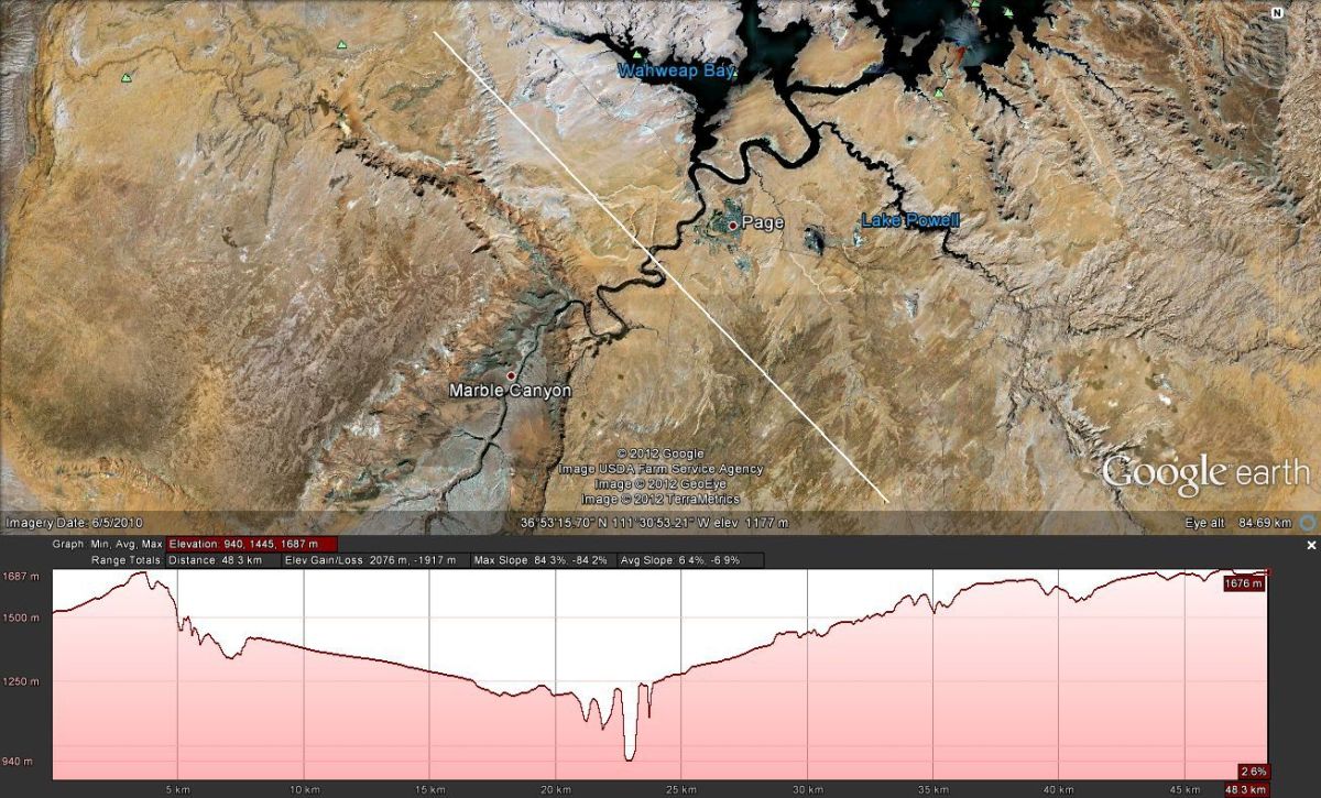
Google Maps is an excellent tool for examining the area (figure 2). Horse Shoe Bend sits near the town of Page and is about 8 km (5 miles) downstream of Glen Canyon Dam. In this section the Colorado River takes a winding course for 25 km (16 miles) from Lake Powell (dark water to the top right of image) to Marble Canyon (bottom left), which is upstream of Grand Canyon. So deeply has the river cut into the plateau that sightseers need to be careful at the rim of the bend, where there is a drop of 300 metres (1000 feet) to the bottom (figure 1).

It is a simple matter to picture the receding waters of Noah’s Flood and see how well that explains the landscape:
- In the ‘second half’ of Noah’s Flood, as the waters began to recede from the continents into the ocean, they initially flowed in wide sheets. In this area they would have flowed in a south-west direction, cutting the large, flat plateau on which the town of Page sits (figure 2). This erosion is obvious to geologists and they have called it The Great Denudation. Kilometres of sediment have been eroded from a vast expanse above the plateau by this sheet-flow phase of Noah’s Flood.
- With time the water flow reduced but still flowed in enormous channels. The erosion that this caused can be seen in the cross section shown in figure 3 (generated using Google Earth). Here the flow channel is more than 30 km (20 miles) wide. The present course of the Colorado River sits in a deep slot that runs along the middle of this channel. This dual-shaped cross section is a typical signature of the recessive stage of Noah’s Flood. For more information see A receding Flood scenario for the origin of the Grand Canyon (at Feature 5 of the article).1
- This enormous channel is the evidence that the geologist above expected, when he said the water from the Flood would flow in a large gush in one direction. However, he did not make the connection because he was not thinking of a large enough gush.
- As the North American continent continued to rise and the ocean level fell, the surface of the plateau around Page emerged. Note that the plateau would have been undulating rather than flat, similar to the uneven surface on the beach when the tide goes out. The water that continued to flow, draining the ponded areas upstream (such as Lake Powell and beyond), would have flowed along the lowest parts of the landscape, following the winding, meandering route that we now see.
- The geologist above was likely correct when he said the river was flowing just above sea level when Horse Shoe Bend was being eroded. Marble Canyon was likely full of water and eroding in an upstream direction. The water flowing down the Colorado River from Lake Powell flowed into Marble Canyon, probably forming a hydraulic jump at the escarpment (e.g. Example on YouTube).2
- At present, The Colorado River is much smaller than Horse Shoe Bend (figure 1), suggesting that a much larger volume of water flowed through the bend as it was being carved. This area of the US is relatively dry with the average rainfall for Page3 being less than 18 cm (7 inches) per year. Such meagre rainfall is unlikely to produce the flow of water needed to erode such a deep gorge.
- As the water continued to drain during the Flood, and the water level in Marble Canyon dropped (technically described as a lowering of ‘base level’) the flow cut the canyon deeper, but continued to follow the pre-existing meandering shape.
- The flow of water was not slow and gentle as the term ‘meander’ suggests. The shape of the river was determined by the undulating surface of the plateau. The entire discharge of the enormous ponded area upstream on the plateau would have been through this section of river.
- Geologist Steve Austin in his book Grand Canyon: Monument to Catastrophe explained how the conditions that carved these deep canyons have been studied in a large flume in the laboratory.4 It was found that the canyon needed a high discharge rate and lowering of base level in order for the meanders to be incised vertically. In other words, the deep canyon points to high energy flow. When the flow rate is low the alluvium in the channel would not be swept away and the channel would be cut horizontally, not vertically.
- Note that upstream of Page the canyon (as delineated by the dark waters of Lake Powell, figure 2) is shaped like a fern frond (a fractal shape). This indicates that, as the river was cutting deeper into the plateau, water was ponded in large areas upstream. The fractal shape is produced when the ponded water drains sideways into the long canyon now filled by Lake Powell. For further discussion on this process see A receding Flood scenario for the origin of the Grand Canyon (at Feature 2 of the article).
- Since the section of river between the Glen Canyon Dam and Marble Canyon was draining a large ponded area upstream, it is actually a water gap, which is another tell-tale feature of Noah’s Flood. The Colorado Plateau in this area displays many water gaps. For more information on water gaps see Do rivers erode through mountains?5
So, contrary to what the Californian geology professor claimed, Horse Shoe Bend and the landscape surrounding it are elegantly explained by the receding waters of Noah’s Flood. Actually, it is difficult to see how these features could be explained by slow-and-gradual processes.
References
- Scheele, P., A receding Flood scenario for the origin of the Grand Canyon, Journal of Creation 24(3):106–116, 2010. Return to text.
- Hydraulic jump, http://en.wikipedia.org/wiki/Hydraulic_jump. Example on Youtube: http://www.youtube.com/watch?v=kEHHf5gJE5A. Return to text.
- Glen Canyon: Weather and Global Warming, National Park Service, August 2007, http://www.nps.gov/glca/naturescience/weather.htm. Return to text.
- Austin, S.A. (Ed.), Grand Canyon: Monument to Catastrophe, Institute for Creation Research, pp. 98–99, 1994. Return to text.
- Oard, M.J., Do rivers erode through mountains? Water gaps are strong evidence for the Genesis Flood, Creation 29(3):18–23, 2007. Return to text.

Readers’ comments
Comments are automatically closed 14 days after publication.