

Coastal great escarpments caused by Flood runoff
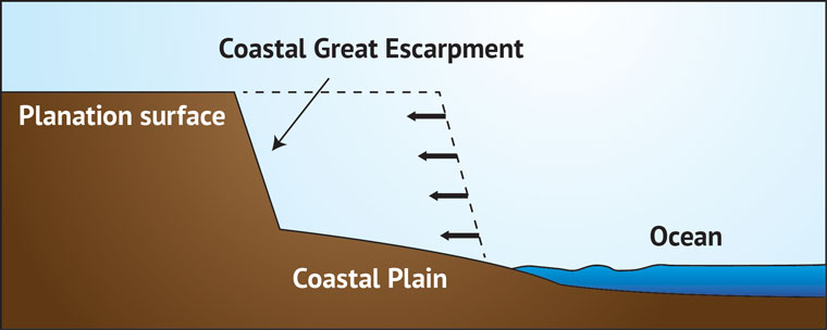
Coastal great escarpments are steep slopes or cliffs found along some continental coastal areas. They are usually very long—several thousand kilometres—and often over 1,000 metres (3,300 feet) high.1 They run parallel to the coast, typically 100 to 200 kilometres (60 to 120 miles) inland, and are not the result of faults that caused the land to uplift, but are formed by erosion. Coastal great escarpments separate a high plateau (an erosion or planation surface2) from a coastal plain (Figure 1).
They are one of the most significant topographical features found on earth.3 Remarkable examples of coastal great escarpments encircle southern Africa, and run along eastern Australia, eastern Brazil, and western India.
Southern Africa
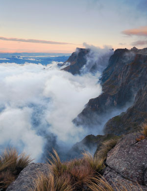
The most impressive escarpment runs nearly continuously parallel to the southern African coast. It starts in the west in Namibia, swings around the southern tip of Africa, and ends towards southern Mozambique. It is 3,500 kilometres (2,200 miles) long but with several large gaps. In Namibia it is more than 100 kilometres (60 miles) inland from the coast but in southeast Africa it is about 200 kilometres (120 miles) inland. The steep scarp is formed on generally horizontal sedimentary rocks, except in Namibia.4 One portion of this escarpment, the Drakensberg great escarpment, inland from the southeast African coast, is 3,000 metres (10,000 feet) high (Figure 2). It is a major erosional feature that separates a high planation surface from a more eroded coastal plain.5 The high planation surface is part of the African Surface that covers much of Africa.6,7
Eastern Australia
The Australian great escarpment runs north-south just inland from the coast of eastern Australia.8 It is over 2,400 kilometres (1,500 miles) long and varies in height from 200 to 1,000 metres (650 to 3,300 feet).
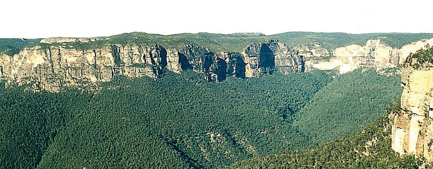
Figure 3 shows the vertical cliffs of the escarpment west of Sydney, Australia. There are several gaps where the scarp cannot be continuously traced with confidence. The escarpment separates a high plateau or tableland from an eroded coastal strip, similar to southeast Africa. The plateau is an erosion surface which has shaved flat the underlying rocks, some of which are sharply inclined to the horizontal. In these areas isolated erosional remnants have been left behind near the escarpment (Figure 4).
Western India
Most of Peninsular India is ringed with an escarpment, similar to southern Africa. It is best developed in western India, where it has a total length of over 1,500 kilometres (900 miles). The height of the escarpment varies, with its highest point being in the southern region at about 2,200 metres (7,200 feet).9 Its distance from the coast varies from 30 to 100 kilometres (20 to 60 miles).
Eastern Brazil
In eastern Brazil a well defined escarpment separates a high area, called the Brazilian Plateau, from a coastal plain,10 similar to other coastal Great Escarpments. The highest section is called the Serra do Mar and extends 800 km (500 miles) parallel to the coast with a maximum height of 2,245 metres (7,300 feet).11

Blue Ridge Mountains Escarpment, USA
The Blue Ridge Escarpment of the southern Appalachian Mountains is also considered a great escarpment, although low in comparison to others. It is about 500 kilometres (300 miles) long and averages 300 to 500 metres (1,000 to 1,600 feet) high.12 It is steepest in western North Carolina, where it rises vertically about 600 metres (2,000 feet) (Figure 5).
Secular geological difficulties

Coastal great escarpments were not caused by faults that uplifted the plateaus, but appear to have been formed by erosion, which removed the land near the coast, leaving a coastal strip, at or near sea level, up to 200 kilometres (125 miles) wide (Figure 1). This, as well as other unexpected geologic features, presents a puzzle for secular scientists, who believe erosion occurred slowly over many millions of years.
These uniformitarian geologists would expect the amount of erosion to be affected by the hardness of the underlying rocks. Softer rocks should erode faster than harder ones, which is what we observe today. But, although these escarpments formed on different rocks with variable hardness they display only minor modification due to the different rock types.4,5 The general erosional process paid little or no attention to the hardness of the rocks.
Geologists who believe in long ages also try to explain the erosion in terms of changing local climates. However, the escarpment in southern Africa crosses areas that have a great variety of climates, ranging from warm-humid to desert.7 Yet, the escarpment itself maintains a similar shape regardless of the climate. This provides another inconsistency for the uniformitarian principle upon which secular geology is built.
The most perplexing aspect of coastal great escarpments is that the actual rate of erosion is too fast for the secular geologists’ timescale. If the Great Escarpment in southern Africa began at the coast, as is widely believed, some geologists think it eroded inland 160 kilometres (100 miles) in ‘only’ 30 million years (within their time frame).6 However, other geologists believe such erosion should have taken much more time.
To overcome these problems, some secular geologists have suggested the entire area could have eroded downward with the steep escarpment remaining in place for millions of years. This alternative is not favorable to their philosophy, mainly because once the planation surface formed it does not appear to have eroded downward by much.13 Moreover, escarpments should become more rounded with time, since steep slopes and vertical faces erode much faster than horizontal surfaces.14,15
Great escarpments formed during floodwater retreat
Those who have studied coastal great escarpments admit they were formed by continental uplift, when the ocean basins sank thousands of metres.16 This is exactly what we would expect in the second part of Noah’s Flood, when the continents rose, the ocean basins sank, and the floodwaters receded into the ocean. The enormous continental erosion would have taken place during the early part of the Recessive stage of the Flood.17 Initially, during the Abative or Sheet-Flow Phase, the water would have covered huge areas of the continents, and flowed as very wide currents, likely hundreds to thousands of kilometres across.18 A characteristic of Flood erosion is it would have no relationship to the present climate and little correlation to the hardness or softness of the underlying rocks, which would have been carved equally by the fast-flowing water.5 The erosion was rapid since erosion over millions of years would have rounded the escarpments.

Figure 6 illustrates schematically what Flood erosion in southeast Africa would do as the continent uplifted and the ocean basins sank.6 Vertical uplift of the continents relative to the ocean basins, along with the action of the receding floodwater, would have formed the African Planation Surface (Figures 6a and b). Continuing erosion would have cut the coastal great escarpment, which began at the coast and moved inland as erosion continued (Figures 6b and c). Erosional debris from the Flood would have been swept into the ocean and deposited on the continental margins, which have a gentle slope on the continental shelf, that steepens at the slope (not shown) far from shore.
These gigantic coastal great escarpments, globally distributed and of enormous scale, provide more powerful worldwide evidence of the Genesis Flood. They are precisely what we would expect to form during the second part of that event, as the continents were rising, the oceans were sinking, and the floodwaters were receding into the sea.
References and notes
- Ollier, C.D., Morphotectonics of passive continental margins: Introduction, Zeitschrift für Geomorphologie 54:1–9, 1985. Return to text.
- Oard, M., It’s plain to see: flat land surfaces are strong evidences for the Genesis Flood, Creation 28(2):34–37, 2006. Return to text.
- Van der Wateren, F.M., and Dunai, T.J., Late Neogene passive margin denudation history—cosmogenic isotope measurements from the central Namib Desert, Global and Planetary Change 30:271–307(37), 2001. Return to text.
- Moon, B.P., and Selby, M.J., Rock mass strength and scarp forms in southern Africa, Geografiska Annaler 65A:135–145, 1983. Return to text.
- Ollier, C.D., and Marker, M.E., The Great Escarpment of southern Africa, Zeitschrift für Geomorphologie 54:37–56, 1985. Return to text.
- Burke, K., and Gunnell, Y., The African Erosion Surface: A Continental-Scale Synthesis of Geomorphology, Tectonics, and Environmental Change over the Past 180 Million Years, GSA Memoir 201, Geological Society of America, Boulder, CO, 2008. Return to text.
- Oard, M.J., The remarkable African Planation Surface, J. Creation 25(1):111–122, 2011. Return to text.
- Ollier, C.D., The Great Escarpment of eastern Australia: tectonic and geomorphic significance, Journal of the Geological Society of Australia 29:13–23, 1982. Return to text.
- Ollier, C.D., and Powar, K.P., The Western Ghats and the morphotectonics of Peninsular India, Zeitschrift für Geomorphologie 54:57–69, 1985. Return to text.
- Ollier, C.D., Morphotectonics of passive continental margins with great escarpments; in: Morisawa, M., and Hack J.T. (Eds.), Tectonic Geomorphology, Allen & Unwin, Boston, MA, p. 11, 1985. Return to text.
- Ollier, C., and Pain, C., The Origin of Mountains, Routledge, London, U.K., pp. 210–211, 2000. Return to text.
- Oard, M.J., Origin of Appalachian geomorphology Part I: erosion by retreating Floodwater and the formation of the continental margin, Creation Research Society Quarterly 48(1):33–48, 2011. Return to text.
- King, L.C., The Natal Monocline, second revised edition, University of Natal Press, Pietermaritzburg, South Africa, 1982. Return to text.
- Oard, M.J., Earth’s Surface Shaped by Genesis Flood Runoff, michael.oards.net/GenesisFloodRunoff.htm, 2013, chapter 11. Return to text.
- Twidale, C.R., Geomorphology, Thomas Nelson, Melbourne, Australia, pp. 164–165, 1968. Return to text.
- Pazzaglia, F.J., Landscape evolution models; in: Gillespie, A.R., Porter, S.C., and Atwater B.F. (Eds.), The Quaternary Period in the United States, Elsevier, New York, NY, p. 249, 2004. Return to text.
- Oard, M.J., Massive erosion of continents demonstrates Flood runoff, Creation 35(3):44–47, 2013. Return to text.
- Walker, T., A biblical geologic model; in: Walsh, R.E. (Ed.), Proceedings of the Third International Conference on Creationism, technical symposium sessions, Creation Science Fellowship, Pittsburgh, Pennsylvania, pp. 581–592, 1994. Return to text.


Readers’ comments
Comments are automatically closed 14 days after publication.