

Stone Mountain, Georgia (USA)
An underground ocean of molten magma

Some 25 km (15 miles) east of Atlanta, Georgia, an impressive mountain rises 250 m (800 ft) above the surrounding countryside. Stone Mountain stands alone like the domed shell of an enormous turtle.1 Boasting many popular attractions, such as camping, fishing, a cablecar, and a scenic railroad, the associated park draws several million visitors a year.

Stone Mountain, which is about 8 km (5 miles) around its base, is part of a huge pluton—a gigantic granite body. When you stand on top, it is hard to imagine that the mountain was once many kilometres beneath the earth’s surface. Also, it is hard to imagine that the mountain was a subterranean ‘ocean’ of red-hot molten rock more than 600°C (1100°F) in temperature. The magma originated when movements in the earth’s crust partly melted rocks much deeper down. Movements bent and folded the whole countryside, pushing up the Appalachian Mountains, and squeezing the magma up through the crust, to pool near the surface.
Geologists once imagined that granite plutons formed very slowly, taking millions of years to accumulate and cool. Even the tourist signs at Stone Mountain tell that story. However, research over the past 30 years has changed that view. Rather than slowly creeping into place, geologists now describe granite formation as catastrophic in its suddenness.2
As you walk across the mountain you can occasionally see pieces of broken rock trapped in the granite surface. These are called xenoliths (foreign rocks). As the molten magma rushed up catastrophically through long, narrow cracks in the ground, it ripped out pieces of the surrounding rock and carried them up into the ocean of magma.
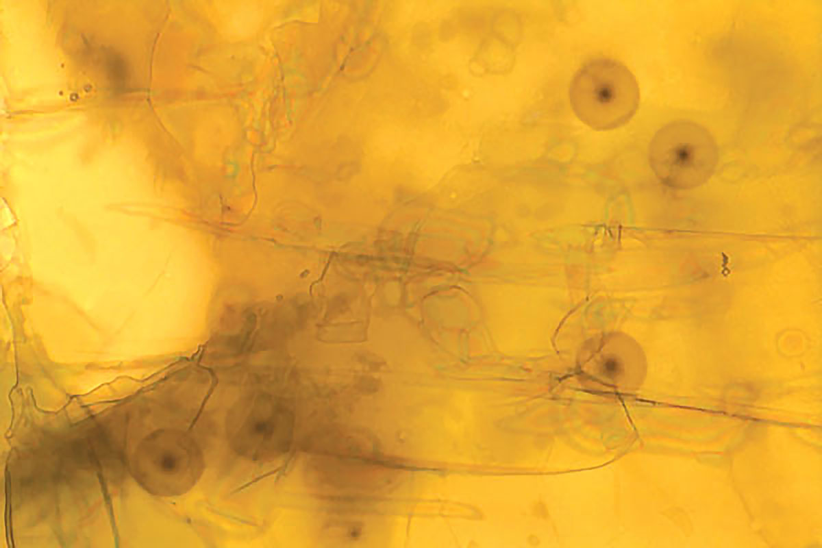
The edges of foreign rocks show a sharp transition between the xenolith and the surrounding granite, indicating the transport and cooling of the magma was rapid. If the xenoliths had been floating in the red-hot magma for a long time, the edges would have started to melt and dissolve and be rounded and fuzzy.3
Another indication that the magma accumulated and cooled super fast is the presence of tiny spheres of discolouration in one of the minerals comprising the granite—the biotite crystals. These spheres were formed by the radioactive decay of polonium-210, an element that disintegrates quickly. This means that the granite had to form very rapidly or else the element would have decayed before the biotite mineral could form.4,5
Such a catastrophic formation of Stone Mountain is exactly what we would expect from the global cataclysm of Noah’s Flood. The first rocks in the area were formed early as the floodwaters were rising. Ongoing movements and collisions within the earth’s crust folded the surrounding rock, melted the magma, and squeezed it up through cracks, into vast underground pools. When the floodwaters peaked and began to flow back into the oceans, they eroded rock kilometres thick from the earth’s surface, exposing Stone Mountain and leaving it standing tall in the surrounding countryside.
Reinterpreting the tourist interpretive sign at Stone Mountain |
||
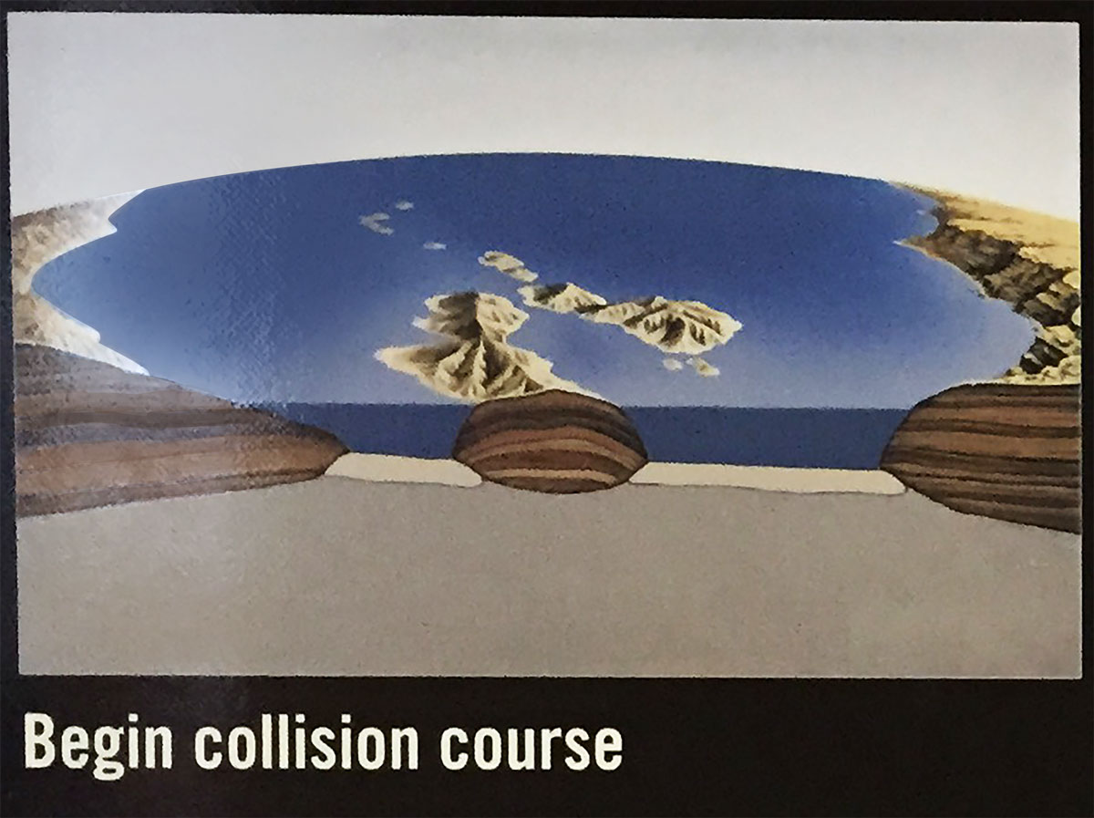 |
What the sign says The energy and force from the Earth’s interior slowly put the pre-continents of Africa and North America on a collision course. |
What really happened In the first stages of Noah’s Flood, 4,500 years ago, vast quantities of sediment and volcanic lava were deposited in thick layers on different parts of the earth. The crust fractured and began to move. |
 |
What the sign says As they continue to come together, ocean islands smashed into the North American continent. |
What really happened The mammoth forces generated by the global catastrophe pushed different parts of the crust together. |
 |
What the sign says The continents converged and eventually collided about 300 million years ago. The steady but unimaginable force of the two colliding masses buckled and fractured the Earth, creating the Appalachian Mountain chain to the west. |
What really happened Crustal collisions buckled, fractured, and metamorphosed the rock previously deposited, forming the Appalachian Mountain chain to the west. |
 |
What the sign says The extreme pressure and heat unleashed from the collision created melted rock or pooling magma below the Earth’s surface. Among the hundreds of magma pools along the Appalachians, one magma pool had the distinction of becoming the future Stone Mountain. |
What really happened The enormous pressure and heat unleashed by the collisions melted rock deep within the earth. Crustal movements squeezed the magma up fractures, causing it to collect in enormous pools, miles below the surface. Among the hundreds of magma pools along the Appalachians, one magma pool had the distinction of becoming the future Stone Mountain. |
 |
What the sign says After a few million years of cooling, Stone Mountain solidified eight to ten miles below the Earth’s surface. |
What really happened Magma crystallized. Escaping water, steam and other fluids rapidly cooled and crystallized Stone Mountain some eight to ten miles below the earth’s surface. |
 |
What the sign says Stone Mountain granite is more resistant to erosion than the surrounding countryside. For 285 million years, the eight to ten miles of land above the mountains wore away, leaving Stone Mountain standing almost 800 ft [250 m] high. |
What really happened After about 5 months, the floodwaters reached their peak and the ocean basins began to sink. For about 7 months floodwaters flowed off the continents, eroding miles of thickness of rock from the surface onto the continental shelves. Resistant Stone Mountain granite remained as an erosional remnant some 800 ft [250 m] high. |
Re-posted on homepage: 4 November 2020
References and notes
- An isolated rock hill like this is also known as an inselberg (island mountain) or monadnock. Return to text.
- Clemens, J.D., Granites and granitic magmas: strange phenomena and new perspectives on some old problems, Proceedings of the Geologists’ Association 116(1): 9–16, 2005. Return to text.
- Froede Jr., C.R., Xenoliths in Stone Mountain granite: evidence for rapid emplacement and cooling of the granitic magma, Creation Research Society Quarterly 34(1):36–38, 1997. Return to text.
- Walker, T., New radiohalo find challenges primordial granite claim, J. Creation 15(1):14–16, 2001; creation.com/radiohalo-flood. Note that Polonium-210 is an isotope (or variety) of the element polonium. Return to text.
- Armitage, M., New record of polonium radiohalos, Stone Mountain granite, Georgia (USA), J. Creation 15(1):86–88, 2001; creation.com/stone-mountain-granite. Return to text.


Readers’ comments
Comments are automatically closed 14 days after publication.