

Journal of Creation 36(1):61–66, April 2022
Browse our latest digital issue Subscribe
Pre-Tejas volcanism in North America: challenge to Hydroplate Theory
The extensive geologic history of volcanism is a centrepiece of nearly all secular and diluvial global tectonic models except Hydroplate Theory (HPT). Proposed in 1972 as a comprehensive explanation of the Genesis Flood, HPT purports to explain 25 major features of Earth. However, despite ubiquitous volcanic deposits throughout the stratigraphic record, HPT has largely ignored volcanism in favour of supercritical water. It relegates continental volcanism to the latter stages of the Genesis Flood, following the formation of most major mountain belts. This diminishes HPT’s explanatory value for the vast pre-Cenozoic volcanic deposits of North America.
Ever since geologists determined basalts were congealed lavas, volcanism has been a focus of global tectonic and geodynamic models. Its extensive record has been interpreted as evidence for gradual processes through deep time, yet research has demonstrated its cataclysmic nature.1 This emphasis on volcanism has been extended to most diluvial models, with the exception of Hydroplate Theory.
Proposed by Dr Walt Brown in 1972, Hydroplate Theory (HPT) claims to explain 25 features of Earth,2 including the distribution and nature of modern volcanoes such as those that form the Ring of Fire.3 Rather than postulating volcanism fuelled by a viscoelastic mantle, HPT sets forth a unique set of initial conditions, including an interconnected shell of supercritical water separating an upper granitic crust from solid basalt basement. This supercritical water would become the driving mechanism of the Flood, leading HPT to predict little volcanic activity prior to its Continental Drift Phase late in the Flood.4 Initiated by up-buckling of the Mid- Atlantic Ridge, this phase’s rapid lateral relocation of the continents drove the continents into their present positions. Their rapid deceleration produced major mountain belts such as the Rocky Mountains and initiated continental volcanism like the Columbia River Basalts of the Pacific Northwest.5 However, HPT’s focus on late-Flood volcanism ignores the volume of volcanic deposits preceding the Cenozoic Tejas megasequence rocks in North America produced during and following the Continental Drift Phase. Understanding these pre-Tejas volcanic rocks is imperative to any global tectonic model.
Hydroplate Theory: a tectonic synopsis
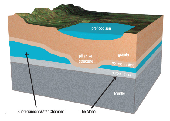
HPT proposes Earth was created with an interconnected shell of water 1.6 km thick, dividing a 100-km-thick granite crust from a basalt basement and solid mantle (figure 1). Continuous lunar tidal pumping 6 caused the subterranean water to reach supercriticality,7 which helped maintain the pre-Flood rainless hydrology for approximately 1,600 years until the Genesis Flood.8

At the onset of the Flood, crustal failure produced linear cracks in the granite through which the supercritical water erupted as the ‘fountains of the great deep’ of Genesis 7:11 (figure 2a). The purported fountains fuelled the 40 days of intense rain, the inundation of the continents, and further expansion of the linear cracks. After the first 40 days, the rising floodwater covered the fountains (figure 2b),9 although subterranean water continued to flow onto the surface of the granite crustal fragments (hydroplates).
Erosion of hydroplate edges continued until portions of the basalt basement up-buckled from the lack of overlying pressure, creating the Mid-Atlantic Ridge. This lowered mantle pressure beneath the Mid-Atlantic Ridge, shifting the subsurface from the Pacific Basin towards the uplifting Mid-Atlantic Ridge. Lubricated by the remaining supercritical water, the hydroplates slid laterally off the rising Mid- Atlantic Ridge towards the deepening Pacific Basin until the supercritical water dissipated and friction halted the hydroplates (figure 2c). Termed the ‘Compression Event’ (CE), this rapid deceleration produced mountain belts such as the Rocky Mountains in North America, while the friction generated by the hydroplates generated magma, fuelling volcanic eruptions such as the Columbia River Basalts. As Brown states:
“Friction at the base of skidding hydroplates and below sinking mountains generated immense heat, enough to melt rock. Crushing produced similar effects, as broken and extremely compressed blocks and particles slid past each other. The deeper the sliding, the greater the pressure pushing the sliding surfaces together, so the greater the frictional heat generated. Where heat was most intense, large volumes of rock melted. High-pressure magma squirted up through cracks between broken blocks. Sometimes magma escaped to the Earth’s surface, producing volcanic activity and ‘floods’ of lava outpourings, called flood basalts, as seen on the Pacific floor and the Columbia and Deccan Plateaus.”4
The liquefaction submodel
Stratigraphy has historically been inextricably linked to tectonic paradigms. The plate tectonics renaissance of the 1960s brought a revolutionary perspective on how sedimentary environments respond to tectonics.10,11 HPT also provides a unique stratigraphic paradigm in its liquefaction submodel. It proposes that diluvial strata were produced by repeated wave-induced continental-scale liquefaction that sorted grains into graded successions.
As the fountains inundated the continents, pre-Flood regolith and eroded granitic crust were deposited atop the hydroplates, which were ‘fluttering’ in response to water hammers being generated in the subterranean chamber. This caused tsunami-like waves to travel across the hydroplates. The increased pressure beneath crests and decreased pressure beneath the troughs gradually sorted sediments into roughly homogenous units, which would have continued until the hydroplates grounded on the basalt basement during the CE. This rapid deceleration also caused the sediment on the hydroplates to decelerate and compress, releasing massive amounts of water that further stratified the sediment. Brown explains:
“Likewise, each decelerating granite hydroplate acted on the bottom sedimentary layer riding on the hydroplate. Sedimentary layers, from bottom to top, acted in turn to decelerate the topmost layers. As each water-saturated layer decelerated, it was severely compressed—similar to suddenly squeezing a wet sponge. Sediments, forced into a denser packing arrangement, released water. Sedimentary particles were crushed or broken, so their fragments filled the spaces between particles, releasing even more water. The freed water, then forced up through the sediments, caused massive liquefaction. As the sedimentary layers decelerated and compressed, they became more and more fluid. Eventually, some layers were so fluid that slippage occurred above them, as in our [example] deck of cards. Below that level, extreme compression and liquefaction caused fossils to float up and collect at this watery level where sliding was taking place.”12
This reorganization of the sedimentary fabric produced vast sedimentary sheets across the current continents, but beneath the primary slippage zone the strata were compressed and tipped diagonally:
“As slippage began during the compression event, layers below the slippage plane continued to compress to the point where they tipped. The sliding sedimentary block above the slippage plane beveled off the still soft tops of the tipped layers.”13
Brown illustrates this instance at the Grand Canyon (figure 3), suggesting that the Great Unconformity represents such a slippage plane, dividing the horizontal Paleozoic strata from the underlying tipped and bevelled Grand Canyon Supergroup.13

A comprehensive stratigraphy?
While traditional stratigraphy sees strata forming by a host of processes in various environments,14 HPT focuses on liquefaction to explain most of Earth’s sedimentary deposits, making few predictions for rigorous field studies. Creation educator J.D. Mitchell applied HPT to John Day Fossil Beds,15 but most of his interpretations were similar to traditional stratigraphy or were general answers offering little more insight. As such, HPT has yet to demonstrate a practical field stratigraphy.
Nonetheless, HPT does allow some predictions. First, sediments should be found near the stratigraphic level at which they were initially deposited. Brown said the fossil succession found within the stratigraphic record was produced by the relative buoyancy of animal carcasses, but sediment grains would have densities closer to each other than to carcasses. Therefore, grains would not rise to the surface during liquefaction but instead would be concentrated near the level where they were deposited, creating graded deposits and cyclothems as proposed by Brown.16 Thus, the presence or absence of a substance (e.g. lithic or mineral) in the stratigraphic record should reflect the processes active at the time a cyclothem or sequence was being deposited and initially sorted.

Second, volcanics should be overrepresented in the most recent rocks. After all, HPT proposes that volcanism began only during the waning phases of the Genesis Flood after most strata had already been produced. Brown states that the first major volcanic outpourings on North America were the Columbia River Basalts following the formation of the Rocky Mountains during the CE at the close of the Continental Drift Phase.9 This implies volcanism initiated in North America in the Tejas megasequence (Paleogene and Neogene), the highest of seven primary unconformity-bounded series of strata (figure 4). Therefore, pre-Tejas volcanism should be small to non-existent in North America.
Third, volcanic deposits should rarely, if ever, contain interbedded or overlying sedimentary strata. After massive liquefaction in the CE, the grounded hydroplates would have lost the flutter that produced wave-induced liquefaction and thus the requisite process for stratification. Instead, the subsequent outpourings of flood basalt would be surficial in nature or overlain by ungraded deposits. This would be far different than the stratified deposits formed earlier in the Flood.
These predictions allow us to test the expectations of HPT against the stratigraphic record. Because sediment grains would be concentrated in cyclothems near the stratigraphic level where they were initially deposited, HPT would expect little to no evidence for volcanism before the CE and subsequent outpourings of flood basalts, which would not be interbedded with or overlain by stratified sediments. Therefore, volcanics should be most commonly present as surficial rocks above the basement of orogens such as the Rocky Mountains, which had formed during the CE. Conversely, extensive volcanics older than the Rocky Mountains (and thus the Tejas megasequence) would conflict with HPT predictions.
Pre-Tejas volcanism in North America
Based on geological and geophysical data collected from boreholes, site investigations, and published fieldwork, Clarey and his colleagues have catalogued the nature and extent of much of the stratigraphic record into seven continental-scale unconformity-bounded sequences of strata, termed megasequences.17 While some have argued that megasequences are based on the Geologic Column,18 considered by some HPT advocates as a ‘mental abstraction’,19 these megasequences can test HPT on a continental scale because they provide a broad generalization of the actual rock record. Furthermore, they generate a frame of reference anchored to events like the uplift of the Rocky Mountains (Tejas megasequence), which in turn can be correlated to HPT’s Compression Event (table 1).20 Thus, ‘pre-Tejas’ rocks, correlating with rocks predating HPT’s Compression Event, can test HPT’s predictions and the rock record.
The seven megasequences cumulatively comprise the bulk of strata on most continents. In North America, the lowest megasequence is a diminutive ‘pre-Sauk’ comprised primarily of clastics and volcanics, followed by the Sauk, Tippecanoe, Kaskaskia, Absaroka, Zuni, and Tejas megasequences, respectively, which also increase in volume and amount of volcanic contribution. Volcanic rocks comprise 18% of the Tejas megasequence (17,800,000 km3 21), the last and most extensive of the seven megasequences. Only a small portion of the 3,200,000 km3 of volcanic rocks is represented by the Columbia River Basalts, which occupy merely 210,000 km3.22
The pre-Tejas megasequences, correlating to HPT’s Flood Phase in North America, each contain 1–7% volcanics. This totals approximately 1,750,000 km3 of volcanogenic strata, over half the volume of volcanics in the Tejas megasequence. As can be seen along the North American Midcontinent Rift System23 or the Cordilleran Margin,24 these can be both lava flows and volcaniclastics.
Too much volcanism before the Compression Event
Extensive pre-Tejas volcanism in North America challenges HPT because it predates the CE (see table 1). Many pre-Tejas volcanic rocks have been deformed and/or folded in mountain belts such as the Appalachians or Rocky Mountains, supposedly produced during the CE, such as the Cardenas Basalt.25 A member of the Grand Canyon Supergroup, the pre-Sauk Cardenas Basalt must have been tilted and bevelled along with the Shinumo Sandstone and other beds allegedly inclined during the CE.26 Similarly, volcaniclastics are often stratified and can contain fossils associated with their stratigraphic position, thereby requiring liquefaction. For instance, the rich fossiliferous Two Medicine Formation in central Montana contains interbeds of residual ash despite being folded into the Willow Creek Anticline during the Laurentide Orogeny or Compression Event of HPT.27 This pales in comparison with the immense Ordovician ash-fall tephra folded in the Appalachians,28 yet such residual ash deposits are found throughout the North American stratigraphic record, requiring extensive volcanism before HPT’s Compression Event.

HPT cannot explain this extensive pre-Tejas volcanism. After all, HPT requires both flows and volcaniclastics to occur near the stratigraphic level they were produced at, providing a datum on the initiation of volcanism within the stratigraphic record. Because HPT’s solid mantle cannot provide a source of magma to the hydroplates, it must assume that magma came from frictional heating of the hydroplates during the CE when the hydroplates collided with obstacles or ground upon the basaltic basement. At no other time is enough friction generated. Prior to this, the hydroplate could only make contact with the basalt basement as a pillar at rest or as a fluttering edge, which would only have pulverized the hydroplate edge as it was lubricated by the near-frictionless supercritical fluid. Thus, with no mechanism to produce magma, HPT has no explanation for the vast volcanic outpourings predating its CE.
Conclusions
Though volcanism is central to most modern tectonic and geodynamic models, HPT stands alone, relying on supercritical water as the driving force of the Genesis Flood. This forces HPT to focus on recent volcanism. Despite the distribution of modern volcanic activity being one of its claimed strengths, HPT fails to explain the extensive volcanic record of the pre-Cenozoic.
While HPT’s liquefaction submodel does not provide a comprehensive stratigraphy, several primary assumptions can be identified to test HPT. Because sediments should be found at the stratigraphic horizon at which they were formed, volcanism should be found only in late Flood rocks and be overlain by, or interbedded with, little to no strata. HPT claims the Columbia River Basalts mark the initiation of North American volcanism during deposition of the Tejas megasequence following the CE. However, the volume of North American pre-Tejas volcanic rocks challenges this assumption. Stratification by alleged liquefaction, deformation by mountain building, and deformation by the CE indicate that these pre-Tejas volcanic rocks cumulatively preceded the CE. Without a connection to a viscoelastic mantle or a means to generate magma through friction, HPT cannot account for the presence of so much early Flood volcanism prior to the CE.
HPT’s inability to explain the volcanic record questions not only its liquefaction submodel but the entire paradigm. To be considered a working model for the Genesis Flood, revision of HPT is necessary to defend its tenets and accurately portray geohistory.
References and notes
- Reed, J.K., Three early arguments for deep time—part 2: Volcanism, J. Creation 26(1):61–70, 2012. Return to text.
- Brown, W., In the Beginning: Compelling evidence for creation and the Flood, 9th edn, PDF, Mission Imperative Inc., Lebanon PA, 2019. These 25 features are introduced on p. 111–122. Return to text.
- Brown devotes an entire chapter to the Pacific trenches and the Ring of Fire in Brown, ref. 2, pp. 152–193. Return to text.
- Brown, ref. 2, pp. 134–135. Return to text.
- HPT proposes that the up-buckling of the Mid-Atlantic Ridge furthermore produced the Pacific Basin trenches, which has been challenged using morphologic and spatial characteristics; in: Isaacs, E., Hydroplate Theory—problems for trench formation in the Pacific Basin, J. Creation 32(3):58–63, 2018, and Isaacs, E., Edward Isaacs responds: Hydroplate Theory—problems for trench formation in the Pacific Basin, J. Creation 33(2):61–64, 2018. Return to text.
- Brown, ref. 2, p. 474. Return to text.
- The supercritical phase is when a fluid is “at a temperature and pressure above its critical point, where distinct liquid and gas phases do not exist”. Supercritical fluid, en.wikipedia.org/wiki/Supercritical_fluid, accessed 1 January 2018. Return to text.
- For details, see “Did It Rain before the Flood? What Generated the Preflood Mist?”; in Brown, ref. 2, p. 477. Return to text.
- “After 40 days and 40 nights, the avalanche of rain (geshem4 rain) stopped, because the layer of water rising on the earth reached a tipping point and suddenly poured into and suppressed the high jetting of the fountains of the great deep. [See “The Water Prevailed” on page 493.] However, high-pressure, subterranean waters continued to gush out and add to the rising floodwater. On the 150th day, floodwaters covered all preflood mountains. Then, the floodgates were closed by the hydroplates slowly settling onto the chamber floor, pinching shut the outward flowing water.” Brown, ref. 2, p. 491. Return to text.
- “The underlying control on the formation of sedimentary basins is plate tectonics and hence basins are normally classified in terms of their position in relation to plate tectonic setting and tectonic processes. Each basin type has distinctive features, and the characteristics of sedimentation and the stratigraphic succession that develops in a rift valley can be seen to be distinctly different from those of an ocean trench. A stratigraphic succession can therefore be interpreted in terms of plate tectonics and places the study of sedimentary rocks into a larger context [emphasis added].” Nichols, G., Sedimentology and Stratigraphy, 2nd edn, Blackwell Publishing, Oxford, UK, p. 381, 2013. Return to text.
- “[A] steady drumbeat of progress in understanding sedimentary rocks has taken place, punctuated at intervals by significant new developments in tools and techniques for studying sedimentary rocks and emergence of new concepts and ideas about their origin. Especially noteworthy among these seminal events were … development of one of the most far-reaching concepts in geologic philosophy—seafloor spreading and global plate tectonics—in the early 1960s.” Boggs, S., Jr., Principles of Sedimentology and Stratigraphy, 4th edn, Pearson Education, Upper Saddle River, NJ, p. xviii, 2006. Return to text.
- Brown, ref. 2, p. 203. Return to text.
- Brown, ref. 2, p. 203 and 207. Return to text.
- Reed has proposed methods of applying this to local areas, as seen in Reed, J.K., Strategic stratigraphy: reclaiming the rock record! J. Creation 19(2):119–127, 2005. Return to text.
- Mitchell, J.D., The Hydroplate Model applied to central Oregon; in: Mitchell, J.D., Discovering the Animals of Ancient Oregon, Leafcutter Press Publisher, Southworth, WA, pp. 75–91, 2013. Return to text.
- See Brown, ref. 2, p. 199. Return to text.
- For an overview, see Clarey, T., Carved in Stone: Geological evidence of the worldwide Flood, Institute for Creation Research, Dallas, TX, 2020. Return to text.
- Froede, C.R., Jr., Akridge, A.J., and Reed, J.K., Can ‘megasequences’ help define biblical geologic history? J. Creation 29(2):16–25, 2015. Return to text.
- For instance, see Mitchell, ref. 15, pp. 92–104. Return to text.
- See table contrasting biblical chronology to that proposed by Hydroplate Theory in Brown, ref. 2, p. 490. At the climax of the Flood at day 150, Brown states: “Hours later [after Mid-Atlantic Ridge uplifted], the massive hydroplates decelerated and crashed; they were crushed, thickened, buckled, and heated in a powerful compression event [emphasis in original; brackets mine].” Return to text.
- Clarey, ref. 17, table 20.1, p. 473, and associated data charts throughout. Return to text.
- Reidel, S.P., Camp, V.E., Tolan, T.L., and Martin, B.S., The Columbia River flood basalt province: Stratigraphy, areal extent, volume, and physical volcanology; in: Reidel, S.P., Camp, V.E., Ross, M.E., Wolff, J.A., Martin, B.S., Tolan, T.L, and Wells, R.E. (Eds.), The Columbia River Flood Basalt Province: Geological Society of America Special Paper 497, p. 1–43, 2013 ǀ doi.org/10.1130/2013.2497(01). Return to text.
- Reed, J.K., The North American Midcontinent Rift System: An interpretation within the biblical worldview, Creation Research Society Books, Chino Valley, AZ, 2000. Return to text.
- Dickinson, W.R., Sedimentary basins developed during evolution of Mesozoic-Cenozoic arc-trench system in North America, Canadian J. Earth Sciences 13(9):1268–1287, 1976. Return to text.
- Timmons, J.M., Bloch, J., Fletcher, K., Karlstrom, K.E., Heizler, M., and Crossey, L.J., The Grand Canyon Unkar Group: Mesoproterozoic basin formation in the continental interior during supercontinent assembly; in: Timmons, J.M. and Karlstrom, K.E., (Eds.), Grand Canyon Geology: Two billion years of Earth’s history, Geological Society of America Special Paper 489, p. 25–47, 2012 ǀ doi.org/10.1130/2012.2489(02). Return to text.
- Brown describes how the quartzite Shinumo Sandstone must have been bevelled and metamorphosed during the Compression Event yet ignores the presence of the Cardenas Basalt, as can be seen in figure caption 36 I, Brown, ref. 2, p. 203. Return to text.
- Shelton, J.A., Application of Sequence Stratigraphy to The Nonmarine Upper Cretaceous Two Medicine Formation, Willow Creek Anticline, Northwestern, Montana, Master of Science Thesis, Montana State University, Bozeman, MT, 2007. Return to text.
- Huff, W.D., Bergström, S.M., and Kolata, D.R., Gigantic Ordovician volcanic ash fall in North America and Europe: Biological, tectonomagmatic, and event-stratigraphic significance, Geology 20(10):875–878, 1992. Return to text.
- Isaacs, E., Hydroplate Theory—problems for trench formation in the Pacific Basin, J. Creation 32(3):58–63, 2018. Return to text.
- Gootee, B.F., Geologic timeframe of the Grand Canyon, Arizona Geological Survey Open-File Report OFR-18-02, 2019. Return to text.


Readers’ comments
Comments are automatically closed 14 days after publication.