

Journal of Creation 30(3):123–127, December 2016
Browse our latest digital issue Subscribe
Where was Eden? part 2: geological considerations—examining pre-Flood geographical details in the biblical record
Creation in-depth: Where was Eden?
Part 1 of this article discussed the textual and geographic evidence that one must use to attempt to locate Eden, the garden, and the associated rivers described in Genesis 2. We concluded that there is no textual reason to assume it can be located on any modern landscape and that no geographical candidates exist that fit the given data. In the second part of this article we will analyze several critical geological features of heavily eroded surfaces that further confirm the idea that Eden cannot be placed on the contemporary surface of the earth.
Munday, while attempting to build a case against the biblical, global Flood, correctly argues that young-earth creationists who claim that Noah’s Flood wiped out the antediluvian landscape attribute much more destructive force to the Flood than other interpreters (like Calvin) throughout church history.1 However, geology was not a science during Calvin’s time, and since then we have found that there are multiple kilometres of sedimentary strata beneath the most commonly proposed location of Eden. Carol Hill expresses the problem well:
But modern geological study has shown (by oil drilling) that the landscape of southern Iraq is underlain by six miles [10 km] of sedimentary rock. Thus the question can be asked: How could the Garden of Eden, which existed on a pre-flood landscape existing before the flood, have been located over six miles of sedimentary rock created during the flood?2
This is a serious consideration, and anyone who attempts to search for Eden on a modern map must take this into account. Would the topographic features described in Genesis 2 be visible after potential scouring at the onset of the Flood, massive deposition of sediments in the early stages of the Flood, and further massive erosion of sediments during the recessional stage of the Flood? When thinking about what would be required to find Eden after all this potential geological change, the Princess and the Pea fairy tale comes into mind: each layer of geological change creates one more barrier to the detection of the original land surface. Add to this the creationist model of Catastrophic Plate Tectonics3 and we cannot know how much Eden moved during the Flood or even if the location still exists, as it may have been subducted.
Secular plate tectonic theory claims the Persian Gulf is a former rift zone that reversed at some point in the past. According to this theory, the Arabian Plate is currently colliding with the Eurasian Plate, creating the Iranian mountains.4 The tectonic setting of this region is complex, but if we accept the relative order of the events given to us by secular geologists, we might be forced to conclude that the Persian Gulf did not exist prior to the Flood. This would cause us to further question the Mesopotamian Eden hypothesis. Where did the antediluvian Tigris and Euphrates flow to if there was no Persian Gulf?
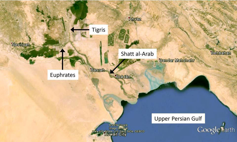
Clearly there are major geological considerations that impinge upon the search for Eden. But there are historical changes to the landscape that must also be taken into consideration. Pliny claimed the two main rivers in the area (the Tigris and Euphrates) emptied into a common lake during the time of Alexander the Great (who died in 323 BC),5 and they may have had separate mouths on the Persian Gulf shore earlier in the historical period (figure 1). Cooke also points out that a town Alexander founded 2.4 km from the shore (c. 320 BC) was approximately 193 km inland by the time of Pliny (c. AD 70).6 This town, Charax, was located near the confluence of the Tigris and Karun rivers, yet the shoreline penetrated further inland at that time (see figure 5 in Cooke6), eclipsing nearly all the region designated by Beitzel7 as the possible southern location for Eden (Beitzel’s map is presented in part 1 of this paper). There are multiple references in ancient history to Ur being on the shore,8,9 which would put the most ancient references to the extent of the Persian Gulf several hundred kilometres inland of the current shoreline and well above the modern confluence of the two rivers. Cooke argues that the early civilizations at Sumer and Susa, both located well inland of the modern shore, were separated by water, because the shoreline at that time was far inland. All this reveals a topological trap for modern people, one into which many professional and amateur historians and theologians have fallen: one cannot simply put their finger on the modern shoreline and then extrapolate history into the ancient past, for the shoreline in many places in the world will move considerably over the historical period.

Because of its low-lying topography, most of Mesopotamia would have been underwater right after the Flood. Initially, ocean levels would have been perhaps 60 m higher than present.10 Sea level was approximately 120 m below present during the height of the Ice Age,11 then rebounded to current levels early in the historical period. Deposition of sediment would have occurred the whole time, meaning the ingressive and regressive shoreline would have happened over different underwater topography and the changes could have been rapid. There currently exists a deep wedge of erosional sediments trending out into the Gulf and sitting on top of Pleistocene-age sedimentary rocks (figure 2). Even for those creationists who hold a ‘high’ Flood/post-Flood boundary, placing it in the ‘late Cenozoic’,12 all parties should agree that this material is post-Flood. Clearly, sediments have continually been deposited throughout the historical period and have made significant changes to the shoreline. Archaeologists are currently using satellite and sediment core data to better understand the complex shoreline history of this region. If the rivers were not connected when Genesis 2 was written, one of the major assumptions behind the majority of work on this subject (that Eden was in lower Mesopotamia) is nullified.
Erosion vs creation

First and foremost, the antediluvian world was not shaped by erosion. True, the land emerged from the ocean on the third day of creation (Gen 1:9–10), but then God immediately created plants (Gen 1:11–13), thus stabilizing the ground and preventing the massive wasting erosion that would have ensued along any significant soil slopes upon exposure to water (subterranean or otherwise). When Genesis describes the land, we should not forget that the original creation is expected to be different from the modern world. The primary shaping force on the post-Flood world, however, is erosion (figure 3). Thus, due to the physical constraints placed upon us by biblical history it might be a fool’s errand to attempt to match the geographic references to the Garden of Eden and its environs with modern topography.
The implications of the modern erosional surface are profound. The most direct implication is that the modern and antediluvian landforms are simply not comparable. For example, in today’s world there are no examples of even two major rivers originating at the same lake or spring, but Genesis 2 has four major rivers originating from the same source. Multiple identical river sources is a physical requirement from the text, but is also impossible to generate from erosional surfaces. Even if it were possible to set up such a system, the lowermost or fastest eroding outlet of any drainage area will always dominate and eventually take over.
Tigris and Euphrates not connected at either end
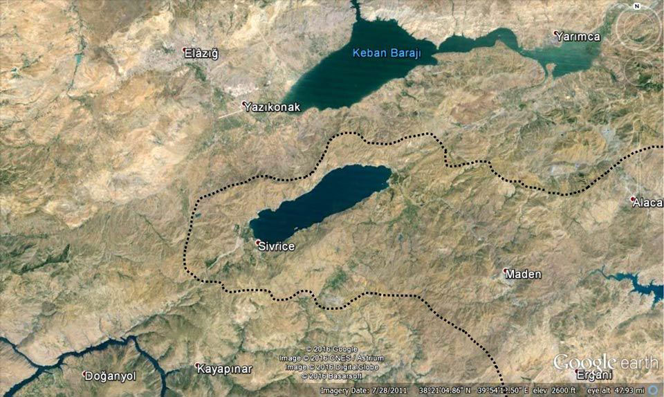
When people attempt to correlate the modern Tigris and Euphrates to the situation in Genesis 2, they generally make one of two possible errors. It is true that the source of the Tigris (Lake Hazar in south-east Turkey) is separated from the Euphrates only by a low saddle of land (figure 4). From a mapping perspective, with a view high above the earth, it appears that the two are quite close to one another. Yet, the source of the Tigris and the source of the Euphrates are not at all close. In fact, the two river basins represent a simple fact of topography: water does not flow uphill and any two river basins will have close contact with other river basins all along their respective edges.
Not only do the Tigris and Euphrates not connect at the source, no other major rivers do either. The source of the Araxes river lies between the two main arms of the upper Euphrates, and other rivers in the area form and flow downhill into the Black Sea or Caspian Sea, but they all follow the same general rules for erosional surfaces described above. Thus, and despite much speculation on the subject by multiple authors, an Armenian location for Eden is precluded by the geography of the area.
Note that Genesis also says that the four rivers start in the same place, whereas the Tigris and Euphrates merge just before they reach the Persian Gulf. But, as we explained above, in ancient times they each had their own mouth, meaning they merged after people started living in the land and the appearance of connectivity is modern. The two rivers were historically not connected at either end.
Rhine and Danube drainage basins are an almost-exact match

The situation with the source of the Tigris and Euphrates is not unusual, for every major river drainage basin is separated from others by a simple change in slope. For example, even though they are connected underground through the porous limestone basement rocks (and later via a canal), the source of the Danube in Germany’s Black Forest and the Rhine present an amazingly similar picture to that of the Tigris and Euphrates (figure 5). The headwaters of the Danube are basically surrounded by the Rhine drainage basin. Yet, nobody would ever claim they have the same source. The only reason people muddle these claims for the Tigris and Euphrates is that they are desperately searching for a correlation between ancient writing and modern topography, and this correlation does not exist.
Extra-biblical evidence
While of course the biblical evidence has primacy, there are a few extra-biblical references one can examine. Specifically, references to a mountain in or near the Garden of Eden can also be found outside the Bible. For example, several scholars have made the case that the most ancient form of Chinese writing contains pictographs that hearken back to the biblical accounts of the Creation and the Fall,13 Noah’s Ark and the Flood,14 and the “lamb of God”.15 Consider the series of symbols from Nelson and Broadberry’s Genesis and the Mystery Confucius Couldn’t Solve and see how they combine to produce the symbol for ‘garden’ (figure 6).16 Note the ‘God’ figure standing on a ‘mountain’ overlooking two people within a bordered enclosure, and note that the mountain stands out prominently.

We must also consider the ubiquitous shape of early religious buildings, from Mesopotamian ziggurats to Egyptian and Mesoamerican pyramids. The idea that a ‘god’ was associated with a high mountain is almost ubiquitous among ancient peoples, to the point where they built artificial mountains far from any heights as places of worship. Real mountains are also traditional ‘holy’ places. This is quite conjectural, but still worth discussing. Why did so many early cultures associate mountain heights with the presence of their god(s)?
Biblical evidence
Since the single river coming out of Eden breaks up into four rivers, we know that Eden must be higher than the surrounding region, perhaps much higher. There is etymological evidence for this. As we demonstrated in part 1 of this paper, the name of the river Pishon (פִּישׁ֑וֹן) means ‘bubbling’ and Gihon (גִּיח֑וֹן) means ‘bursting forth, gushing’.17 Thus the river names themselves may reveal that some significant drop in elevation occurs from the source to the outlet of the rivers. They are certainly not ‘lazy’ rivers.
Interestingly, a mountain is associated with Eden in several biblical references. These are not definitive, but they are worth studying. In the middle of a lament over the king of Tyre, which is also full of references to Eden and allusions to Satan, Ezekiel 28:14–16 says:
You were an anointed guardian cherub. I placed you; you were on the holy mountain of God; in the midst of the stones of fire you walked … I cast you as a profane thing from the mountain of God, and I destroyed [or banished] you, O guardian cherub, from the midst of the stones of fire.
Putting aside a discussion of the ‘stones of fire’, the Edenic imagery that surrounds this passage is clear, and so is the mention of the mountain.
Revelation also talks about a mountain in an Edenic context. Right before the Genesis themes of the “curse” (22:3) and “the tree of life” (22:2, 19) appear, John says:
And he carried me away in the Spirit to a great, high mountain, and showed me the holy city Jerusalem coming down out of heaven from God (21:10).
Like the extra-biblical references to a mountain in Eden, this biblical reference is speculative, one might even say weak; however we decided to include it for the sake of completeness. Here again is a mountain associated with Eden-like themes with the New Jerusalem coming down next to that mountain.
Does all this mean there actually was a mountain in the Garden of Eden? No, and it is admittedly speculative, but it does support the idea that a mountain was in Eden, within or near the garden. Either way, combining the references to rushing or bubbling water in two of the four rivers, the fact that rivers must flow downhill, and the tangential references to a mountain in an Edenic context indicates that the garden was at some elevation. Why do we reference all of this circumstantial material? Because it almost certainly precludes a Mesopotamian location for the garden. Lower Mesopotamia, especially, is nothing more than a flat, alluvial plain.
A model of Eden
There are many possible layouts that include the necessary elements of 1) a garden in a larger area called ‘Eden’; 2) a relative elevation for the source of the river, which flows through Eden before splitting into four rivers; and 3) an eastward progression of features (which is an assumption based on the overall implications from Genesis 2–4).
What is clear, however, is that no modern-day candidate for the location of Eden possesses characteristics resembling this rough schematic. Thus any proponents of modern locations of Eden have to ignore elements of the text which describe elements not present on the modern globe. Not only that, but such proponents are forced to downplay the plain meaning of the Genesis text, to the point where the geographic data given in the text become nearly meaningless. Focusing on just a few of the terms used is insufficient when one must jettison the remaining terms. This is especially important after one realizes that most of the geographic terms are either very common words (and are thus so generic as to be irrelevant in the search for Eden) or are named after post-Flood people (and thus cannot legitimately be used in the search for Eden).17
Conclusions
Part 1 of this paper established that there are no textual or geographical reasons to expect Eden can be located on a modern-day map. Here we establish multiple geological reasons to also conclude that Eden should not be able to be located in the modern world. The modern landscape is shaped by Flood erosion and post-Flood geological activity, which would have obliterated Eden if it were on or near the surface. Also the majority of the continental surfaces have kilometres of sedimentary rock deposited by the Flood. If the sediments can be attributed to Flood deposition, the original Eden is buried deep. One must also examine the fact that sediments are always deposited in slack-flow areas, and that these are almost always in basins (as opposed to topographical high points). Thus, the majority of the modern continental surfaces were either low points prior to the Flood, were dropped below the ocean crust during the Flood, or the oceanic crust was almost totally resurfaced late in the Flood to remove the Flood-deposited sediments. Why would anyone expect Eden to be near the surface in any of these scenarios?
References and notes
- Munday, J.C., Eden’s geography erodes flood geology, WTJ 58:123–54, 1996. See refutation: Hughes, J.R., An examination of ‘Eden’s geography erodes flood geology’, CRSQ 34(3):154–161, 1997. Return to text.
- Hill, C.A., The Garden of Eden: A modern landscape, Perspectives on Science and Christian Faith 52:31–46, 2000. Return to text.
- Baumgardner, J.R., Catastrophic plate tectonics: The physics behind the Genesis Flood; in: Ivey, Jr., R.L. (Ed.), Proceedings of the Fifth International Conference on Creationism, Creation Science Fellowship, Pittsburgh, PA, pp. 113–126, 2003. Return to text.
- See science.nationalgeographic.com/wallpaper/science/photos/plate-tectonics-gallery/persian-gulf-plates/ Return to text.
- Pliny, Natural History VI:XXVI. Return to text.
- Cooke, G.A., Reconstruction of the Holocene coastland of Mesopotamia, Geoarchaeology 2(1):15–28, 1987. Return to text.
- Beitzel, B.J., The New Moody Atlas of the Bible, Moody Publishers, Chicago, IL, p. 89, 2008. Return to text.
- Larsen, C.E., The Mesopotamian delta region: a reconsideration of Lees and Falcon, J. American Oriental Society 95:43–57, 1975. Return to text.
- Jacobsen, T., The waters of Ur, Iraq 22:174–185, 1960. Return to text.
- This is an estimate based solely on the amount of continental ice locked up in glaciers. The potential for isostatic changes readjustments in crustal plate elevation, sea level changes due to post-Flood oceanic cooling, water height adjustment for cooling oceanic crust, etc., complicate this figure. Return to text.
- Fairbanks, R.G., A 17,000-year glacio-eustatic sea level record: influence of glacial melting rates on the Younger Dryas event and deep-ocean circulation, Nature 342:637–642, 1989; note: the present authors assume the data in this paper represent the single Ice Age caused by the Flood and thus do not accept the uniformitarian ages therein. Return to text.
- Oard, M., Geology indicates the terrestrial Flood/post-Flood boundary is mostly in the late Cenozoic, J. Creation 27(1):119–127, 2013. Return to text.
- Nelson, E.R., Broadberry, R.E. and Chock T.C., God’s Promise to the Chinese, Read Books, Berrien Springs, MI, 2014; see also creation.com/chinese-characters-and-genesis. Return to text.
- Voo, K.S., Sheeley, R. and Hovee, L., Noah’s Ark hidden in the ancient Chinese characters, J. Creation 19(2):96–108. Return to text.
- Voo, K.S. and Hovee, L., The lamb of God hidden in the ancient Chinese characters, J. Creation 13(1):81–91. Return to text.
- Nelson, E.R. and Broadberry, R.E., Genesis and the Mystery Confucius Couldn’t Solve, Concordia Publishing House, 1994. See also the review by Grigg, R. J. Creation 9(1):26–28, 1995. Return to text.
- Cosner, L. and Carter, R., Where was Eden? Part 1: examining pre-Flood geographical details in the biblical record, J. Creation 30(3):97–103, 2016. Return to text.


Readers’ comments
Comments are automatically closed 14 days after publication.