

Journal of Creation 32(3):74–81, December 2018
Browse our latest digital issue Subscribe
The Flood/post-Flood boundary along the Arctic coast of North America
It is important to find the correct location of the Flood/post-Flood boundary. The Arctic coastal area is a difficult place to determine this boundary because its unique environment complicates the research. The Pliocene epoch appears to have been much warmer in the Arctic. This supports creationist predictions, while the uniformitarian model fails to predict the warmth. Most geological features indicate the strata in the Arctic coastal region are Flood sediments, with the Flood/post-Flood boundary above the Pliocene. Along the northern slope of Alaska, the Sagavanirktok Formation is also indicative of Flood sedimentary rock, but the overlying Pliocene Gubik Formation along the coast is most likely post-Flood. Thus, the boundary here is likely between the Miocene and Pliocene. This research has implications for uniformitarian dating methods, the biblical history of the Arctic, and the post-Flood Bering Land Bridge.

Since the Flood/post-Flood boundary remains controversial, I have developed 32 criteria for determining its position in the geological column.1 These criteria span most subfields of geology. They include seven factors within sedimentary rocks,2 seven from organic remains,3 five tectonic factors,4 eight evidences from geomorphology,5 and others. I concluded the boundary is primarily in the late Cenozoic, defined as the Miocene, Pliocene, Pleistocene, and Holocene (the latter two comprising the Quaternary) using the geological column as a reference point. Figure 1 displays the geological column from the Archean to the present with the Cenozoic period subdivided into epochs. Uniformitarian dating problems keep us from assigning a precise location on the geological column or definitively stating the Pliocene/Pleistocene is the Flood/post-Flood boundary (see below). Each geographic location must be evaluated on its own merits. For instance, Pliocene and early Pleistocene mammal fossils entombed on the High Plains of the United States would be from the Flood,6,7 while marsupial fossils from Australia, mostly dated to as old as Miocene,8 could easily be post-Flood.
The Flood/post-Flood boundary along the Arctic coast
We now turn to the Arctic coast of North America, because of its unique location in respect to its inaccessibility. Arctic geology is confounded by stratigraphic problems, different names of formations in different areas, changing ages for strata, changing dates for epoch boundaries, claims of reworking, and occasional unique fossil finds. Moreover, the observations are isolated and uniformitarian and evolutionary assumptions and interpretations bias their conclusions. All of this makes it challenging for the biblical geologist to determine precisely the Flood/post-Flood boundary along the Arctic coast, so any current results remain tentative.

Biblical geology predicts finding fossil evidence for a warm pre-Flood climate buried in the Flood. At high latitudes near the pole, during the Flood nearby ‘warm-climate’ pre-Flood vegetation could have been buried or low-latitude vegetation transported to higher latitudes. A warm climate at high latitudes early in the post-Flood Ice Age is also predicted because the Arctic Ocean was warm after the Flood. During the Flood the ocean water was warmed by extensive volcanism, possible impacts, and other possible processes that operated during the Flood. The warmer ocean also caused the atmospheric temperatures to be warmer at high latitudes, greatly increasing the precipitation in the region. In fact, these conditions set the stage for the Ice Age.9 The likelihood that the climate was warm during and immediately after the Flood makes the Flood/post-Flood boundary more challenging to decide, especially if we base the determination on the character of the fossils.
General geology
For determining the Flood/post-Flood boundary, I will only consider options from the Cretaceous/Paleogene (K/Pg) boundary and above. Lower boundaries make little sense in a Flood model,10 and are rejected by most creation scientists.
It appears the rocks in the Arctic represent all geological periods,11 but the Cenozoic mainly outcrops near the Arctic Ocean. It is in this area that the location of the Flood/post-Flood boundary is the most difficult to determine.
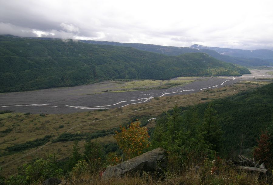
The top sediments and sedimentary rocks along the north slope of Alaska (figure 2) are mostly dated as Cenozoic. They consist mainly of the Sagavanirktok Formation, named after the Sagavanirktok River which flows into the Arctic Ocean, and the Gubik Formation along the Arctic coast that immediately overlies the Sagavanirktok Formation.
Along the north-west coastal plain of the Queen Elizabeth Islands between 72 and 80°N, the Beaufort Formation is the main exposed formation. It stretches 1,200 km long and is about 50 km wide from Banks Island north-east to Meighen Island (figure 3). Some geologists extend the Beaufort Formation eastward to include isolated strata on Axel Heiberg and Ellesmere Islands. Below these Cenozoic strata are the upper Mesozoic and lower Cenozoic Eureka Sound Group.

Pliocene warmth—a major uniformitarian problem
The Pliocene epoch, conventionally dated as 5.33–2.58 Ma (figure 1), just before the uniformitarian Ice Age period, is interpreted to have been warmer and wetter than today,12 though not nearly as warm as the early Tertiary (see below). In fact, some scientists use the Pliocene as a proxy for future global warming. Global temperatures are said to have been 2–4°C warmer in the Late Pliocene just before the ice ages.13 Temperatures were even warmer in the Arctic. Ellesmere Island was 11–16°C warmer,14 and the Canadian High Arctic was 19°C warmer.15 Precipitation is thought to have been three times that of today, at least in north-east Siberia.16 New proxy estimates continue to raise the temperature difference between the Pliocene and today.17 Sea level is believed to have been 35 m higher than it is today18 and sea surface temperatures in the Arctic 6–10°C warmer,19 essentially eliminating sea ice. Moreover, permafrost was thought to be patchy16,20 and forests extended northward to the Arctic Ocean, including northern Greenland21 and northern Siberia.22
Uniformitarian simulations do not explain Pliocene climate
Uniformitarian scientists have modelled Pliocene climates but have run into great difficulties. Problems arose primarily because they assumed external factors, such as geography and atmospheric carbon dioxide, were about the same as today.12,23 To try and make the simulation work, they force fitted warm temperatures by prescribing initial and boundary conditions. For instance, they prescribed constantly warm sea surface temperatures at high latitudes, and stronger north-south winds transporting warm air north. However, these initial conditions were quite artificial.
Interestingly, though, the constantly warm sea surface temperatures allay the uniformitarian difficulties only a little.24 One problem with warm air being transported to high latitudes is that the amount transported is directly proportional to the north-south temperature gradient. Tropical temperatures are believed to be about the same as today or a few degrees warmer.25,26 With much warmer polar temperatures, the gradient was greatly reduced in the Pliocene. So, northward transport of warmer air should have been reduced, not enhanced.
The boundary is above the Eureka Sound Group, Queen Elizabeth Islands
The Eureka Sound Group in north-west Canada is dated as Cretaceous and early Tertiary, and is up to 4,000 m thick.27 It forms the top strata of the 13-km-thick sequence in the Sverdrup Basin that covers most of the Queen Elizabeth Islands.28 Coal is abundant in the group and the Eureka Sound Group shows strong evidence for uniformity over a vast area:
“Everywhere that the Eureka Sound Formation or its direct correlatives are present, there is a predominance of clastic sedimentary rocks with locally abundant coal. This is strong evidence for virtual uniformity of depositional conditions over roughly 2,000,000 square kilometres encompassing a broadly triangular area from north-eastern Ellesmere Island to Banks Island to northern Baffin Island.”29
Fossils found in the Eureka Sound Group—e.g. lemurs, alligators, turtles, and swamp cypress—indicate the paleoclimate ranged from tropical to warm temperate with little seasonal contrast (equable).30,31 The average temperature is claimed to have been 35°C warmer (going from today’s average of –20°C to 15°C) in the Eocene Arctic than it is today.14 This is probably an underestimate, since subtropical to tropical fossils imply an even warmer climate than 15°C. Temperatures with little seasonal contrast and a lack of sunlight for months seem impossible after the Flood.
The isolated outcrops of the ‘Beaufort Formation’ were claimed to be solidly dated by fossils,31 but some of these outcrops are now considered to be part of the Eureka Sound Group.32 The assignment to the Beaufort Formation was “in keeping with the general use of Beaufort Formation for Neogene sediments in the Canadian Arctic Archipelago”.33 In other words, the date and formation simply filled a time slot based on fossils and the inferred climate.
There has been a large amount of literature about the vertical trees found in multiple coal seams in the Geodetic Hills of eastern Axel Heiberg Island.34 Several features of this site, such as unfossilized trees and leaf litters, would suggest a post-Flood climate around a warm ocean early in the Ice Age. But, an analysis of the extensive data indicates that the Axel Heiberg site, as well as other locations on Ellesmere Island, are deposits from the Flood.35,36 The leaf litter was no more decayed at its base than at its top, making deposition after the Flood unlikely.37 A previously formed in situ soil profile would contain much decayed plant matter with depth, which is not apparent here. So, the leaf litters are not associated with soils for the trees. The huge extent, uniformity, depth in kilometres, warm-climate fossils, and the existence of coal all strongly point to the Eureka Sound Group being Flood strata.1 The vertical trees and coal with the transport of warm climate plants and animals can be explained by the creation log mat model.38 This would place the Flood/post-Flood boundary in the upper Cenozoic in this location.
The Flood/post-Flood boundary is probably on top of the Beaufort Formation

This places the Flood/post-Flood boundary in Arctic Canada at the base, within, or at the top of the Beaufort Formation, which outcrops along the coastal plain of the Queen Elizabeth Islands (figure 3). Since this determination is difficult, I will first examine the ‘type site’ for the formation on Prince Patrick Island. The island has the advantage of never having been glaciated, since no glacial till has been found there. It was unglaciated, like other islands and parts of islands in northern Canada, because of the warm Arctic Ocean in the biblical Ice Age model.
Prince Patrick Island type site
The Beaufort Formation on Prince Patrick Island is an unconsolidated wedge of mostly sand that thickens seaward toward the north-west. It is similar to the Beaufort Formation on other islands, where it is capped by glacial debris.39,40 Although outcrops are rather isolated in the central part of the Prince Patrick Island, on the large scale of the Queen Elizabeth Islands the formation is generally uniform. The formation lies on a variety of rocks identified as Paleozoic to early Cenozoic. It is generally horizontal and thickens north-west to possibly 600 m on the north-west coast, and presumably continues to thicken offshore. The Beaufort Formation is covered near the coast, so the thicknesses are an estimate.
There are rapid changes in sediment type (facies changes) on a scale of 5–50 m between all kinds of different sediment from clay to gravel, suggesting a ‘braided river’ uniformitarian depositional model. There is an abundant amount of fresh-looking, water-worn, unfossilized wood lacking bark from mostly coniferous forests. The gravel is mostly rounded to subrounded, resistant lithologies, and paleocurrent directions are toward the west to north-west, i.e. toward the Arctic Ocean. Coal, amber, and pollen are believed to have been reworked from underlying formations. The top of the formation has been planed flat, leaving behind a 1–2-m lag of boulders.
Some of the unusual features of the Beaufort Formation at its type location are about 100 species of vascular plants, 50 bryophyte (non-vascular) species, and 80 species of arthropods, mostly beetles. This is an amazing variety for such a high latitude. However, there are no tree stumps, soils, root zones, or other evidence for plant growth. Some of the plants include types that grow in the boreal forests well south, such as spruce, larch, pine, alder, and birch, but it also includes other types atypical of boreal forest, such as hemlock, fir, cypress, rose, water lily, dogwood, honeysuckle, mint, and hickory. Many of the beetles live in the warmer latitudes to the south today. The fossils indicate a warmer, wetter climate prevailed during deposition.
Moss is found in minor layers of ‘peat’, which is mainly composed of fine woody debris. The peat layers and lenses are up to 30 cm thick. The moss species do not grow together.39 So, the peat and moss had to have been transported. Today, most moss species in the Arctic live further south.
The Beaufort Formation has generally been dated Miocene, Pliocene, and Quaternary, but has been refined recently to the Pliocene of the late Cenozoic, based on fossil correlations with Meighen Island to the north-east.
Other islands
The Beaufort Formation is generally similar on the other islands of the north-west Queen Elizabeth Islands. On Meighen Island it is 220 m thick. The same indicators of a warm climate have been found, including fossils of the eastern cedar that is now found much farther south. One mysterious feature is the occurrence of cross-bedded woody lenses, which have never been found in environments today or in sedimentary rocks.41 It is believed that the wood must have been waterlogged to form cross-beds, but as the wood remains burnable it is more likely not to have been waterlogged, or it has dried out since deposition.
The Beaufort Formation on north-west Banks Island is a strange case. Researchers thought north-west Banks Island was all Beaufort Formation until they ‘discovered’ many fossils that were ‘too warm’ in the lower part of the formation. They therefore ‘redated’ it to the Mid Miocene, based on inferred climate.42,43 The lower strata were renamed the Ballast Brook Formation. Some of the very warm climate fossils they found are the swamp cypress, tulip tree, and the Azolla fern. Matthews even found a plant restricted today to the tropics and subtropics that he believed must have had a “cool-climate variety”.44 There does not appear to be much of a gap at the contact, which represents about 10 million years of missing time, except for a layer of peat with vertical stumps just below the top of the Ballast Brook Formation. This is but one more example of uniformitarian scientists changing their dates to match new research and is one of the reasons why we cannot use a precise date in the geological column for locating the Flood/post-Flood boundary.
The ‘Beaver Pond’ site
There are many possible remnants of the Beaufort Formation on Ellesmere Island, generally in high terraces along valleys and fjords.45 Probably the most perplexing is the ‘Beaver Pond’ site on southern Ellesmere Island at the head of Strathcona Fjord (figure 3). However, it is 2,000 km south-east of the rest of the Beaufort Formation, and may not be related to it at all. It is assumed to be the Beaufort Formation, since it has similar paleoflora.
The site is within 10–40 m of sand and gravel that caps the eroded top of the Eureka Sound Formation.46 The formation is capped by glacial deposits. The site is also in peat that is assumed to have been a beaver pond, because of the existence of an extinct type of beaver and beaver cut sticks.47,48 The peat is located in a terrace 300 m above sea level on the side of a valley that exits into Strathcona Fjord. The peat has mostly extant species of moss and beetles. There are also rooted larch trunks up to 3 m tall.
Unlike the Beaufort Formation, it has many vertebrate fossils, such as the beaver, rabbit, dog, shrew, rodent, badger, horse, deer, camel, and bear.20,47,49 They are dated as Pliocene and placed in the Beaufort Formation. A fish fossil, similar to a walleye or sauger, admittedly is from Pleistocene strata farther south. All these fossils imply a climate about 18°C warmer than today, but they claim discontinuous permafrost and ice wedge casts.20
The Beaufort Formation and the Flood/post-Flood boundary
From criteria that I have developed for the location of the Flood/post-Flood boundary,1 several aspects of the Beaufort Formation would imply a post-Flood environment. The formation is not well-cemented, the wood looks fresh, many of the fossils are from living forms, and there are rapid facies changes, beaver-cut sticks, and moss. However, the Beaufort Formation seems slightly more likely to be a Flood deposit because of its broad extent over the 60,000 km2 area. It is most likely a result of sheet flow coming from the south-east and moving into the deepening Arctic Ocean. The area was subsequently dissected into islands, separated by channels and straits, that can be as deep as 500 m.39,50 The channels between the Queen Elizabeth Islands are believed by uniformitarian scientists to have been formed by rivers in the Oligocene to Pliocene.51 Sheet deposition, followed by deep channelized dissection, fits nicely within the Recessive Stage of the Flood.
Today, braided streams are nearly always less than a few kilometres wide (figure 4). It is extremely unlikely a braided stream formed a deposit over 1,200 km wide. A planation surface caps the formation. The Beaver Pond site was probably made before the channels were cut.46 It seems unlikely the Beaufort Formation is post-Flood. It would take too much time for the forests to grow, and a ‘catastrophe’ to lay down sheet deposits over a huge area, and deep channelized erosion to take place after the Flood and before the Ice Age.
I would place the Beaufort Formation in the Abative Phase of the Flood during sheet deposition in coastal locations and on the continental margin. Late in the Flood, during the Dispersive Phase, the area was dissected by channelized flow that separated the area into islands. Planation surfaces are unique features of the Flood.52,53
The Flood boundary is below the Gubik Formation in northern Alaska
Along the north slope of Alaska, from the Brooks Range to the continental shelf, the Cenozoic strata consists mainly of the Sagavanirktok and the Gubik formations.54,55 The Sagavanirktok Formation is dated as mostly Paleogene with possibly some Upper Cretaceous in the west.56 It is composed of 2,600 m of sandstone, bentonitic shale, conglomerate, and coal that covers the top of the Colville Basin that is greater than 10 km deep. As with the Eureka Sound Formation in relation to the Sverdrup Basin, all but possibly the top of this formation would likely be from the Flood, especially because of the coal.
The Gubik Formation mantles the coastal plain up to 60 m above sea level.55 It is up to 60 m thick onshore and perhaps a few hundred metres thick on the continental shelf. It is mostly marine, unconsolidated, and divided into at least six ‘transgressions’.57 It overlies an erosional surface that cuts across Cretaceous and Tertiary sedimentary rocks. The formation is said to be similar all along the eastern and western shores of the Bering Sea, the Bering Strait, and Chukchi Sea.58 It is ‘correlated’ with the Beaufort Formation on the north-west coastal plain of the Queen Elizabeth Islands, but this is probably just because the Beaufort Formation is also dated Pliocene.
The uniformitarian age of the Gubik Formation has been controversial. It was once dated late Pleistocene and fit within the last two ‘ice ages’ defined from the US Midwest.59 Based mainly on amino-acid geochemistry, fossils, strontium isotopes, and paleomagnetic dating, the Gubik Formation is now dated Pliocene to late Pleistocene. There are three ‘transgressions’ dated to the Pliocene or possibly up into the very early Pleistocene based on isolated outcrops. These transgressions are indistinguishable and rarely superimposed vertically. They are separated in time mainly by various dates, especially amino-acid geochemistry,55 which means that the Gubik Formation could simply be one instance of high sea level giving different dates in different places. There seem to be numerous problems with the dating methods, including tenuous fossil correlations, problematic amino-acid dates, thermoluminescence dates that are too variable, C-14 dates that had to be tossed, failed paleomagnetic analysis, and Sr isotope dating that failed at one location.55,58,60 Again, we cannot use uniformitarian dates to locate the Flood/post-Flood boundary.
The character of the vegetation and the fossils, including sea otter fossils, indicate the climate was very warm.61,62 The sea otter fossils were once dated as 2.4–3 Ma61 but were changed to 1.7–2.6 Ma based on its ‘stage of evolution’. Forests of spruce and birch indicate the climate was too warm for permafrost and Arctic sea ice.57 However, there are ice-rafted rocks from the Ice Age in the Pleistocene section of the Gubik Formation. There also could be glacial rocks in the Pliocene layers. Some fossils indicate colder conditions, such as a harp seal fossil and lemming fossils.
Although the Gubik Formation is widespread, it is thin and lies on a planation surface, which was likely formed by Flood runoff. It could easily have been deposited when the global sea level was about 67 m above the current sea level at the start of the Ice Age because there were no ice sheets on Antarctica and Greenland. Other aspects would point to the Ice Age, especially since the top of the formation has Ice Age indicators.
Implications
At least three implications for creationists result from this study, including uniformitarian dating problems, biblical history, and timing of the Bering Land Bridge.
Cannot depend on uniformitarian dates
From an analysis of the formations in northern North America, I place the Flood/post-Flood boundary above the Pliocene Beaufort Formation, north-west Queen Elizabeth Islands, and between the Sagavanirktok and the Pliocene Gubik Formation in northern Alaska. The analysis demonstrates why we cannot use the uniformitarian geological names or epochs to define the boundary, and why we must evaluate each location on its own merits.
Dating and taxonomic problems are two areas where we cannot use the uniformitarian system, except in a crude sense. McNeil states: “Biostratigraphic resolution is a fundamental problem in the Arctic because of the general absence of standard indices such as planktonic foraminifers and nannoplankton.”63 For instance, a horse jaw with several teeth was found at the Beaver pond site and claimed to be from hipparion,49 probably because that is one of the horses that supposedly lived during the Pliocene. Another example is Bustin’s dating of what is now considered the upper Eocene Eureka Sound Group as the Pliocene Beaufort Formation. He based the date on what was considered an index fossil.31
Circular reasoning conjured these two ‘dates’. Climatic circular reasoning pigeon-holed the lower Beaufort Formation on north-west Banks Island 10 Ma earlier into the mid-Miocene because the fossils were considered too warm. Brigham-Grette and Carter admit that ‘climate history’ is an input into the resultant dates.57
Even epoch boundaries have changed. The upper Miocene was once considered the lower Pliocene, and more recently the upper Pliocene was changed to the lower Pleistocene when the Pliocene/Pleistocene boundary was pushed back from 1.8 Ma to 2.6 Ma.64
Biblical history
Once the Flood/post-Flood boundary is determined at one place it provides insight into the pre-Flood, Flood, and post-Flood history. The large amounts of fresh-looking wood found in the Cenozoic include species from the boreal forests farther south. The large quantities of moss transported along with ground-up plant material (peat) and deposited in the Beaufort Formation indicate the pre-Flood forests were moss-laden at high latitude. This suffices to conclude that the north polar area may have had a relatively cool climate before the Flood, and the forests were transported and buried in the Beaufort Formation sometime during the Flood. The Beaufort Formation is unique in many ways and demonstrates that sheet deposition along the continental margin can also have rapid changes in facies.
During the Flood, the very warm climate trees and plants, such as found on Axel Heiberg Island, could have been deposited by log mats that floated north, occasionally mixing with the local cool climate plants and trees.
After the Flood, there would be no mystery as to why the early Ice Age Arctic was much warmer than it is today, and why Prince Patrick Island, as well as other islands or parts of the other islands of the north-west Queen Elizabeth Islands, were never glaciated. Immediately after the Flood the Arctic Ocean was very warm, which would have resulted in warmer atmospheric temperatures near the ocean than today. It is interesting that there is very little indication of permafrost or sea ice in the Gubik Formation, as predicted by the post-Flood Ice Age model.9 Warm onshore flow would prevent the ice and permafrost from forming near the Arctic coast.
According to the uniformitarian model, glacial temperatures would be much colder than today, while interglacial temperatures would be similar to today. Under these conditions, secular scientists would expect glaciation close to the Arctic Ocean, as well as in the lowlands of Alaska, Siberia, and the Yukon Territory of Canada. They would also expect permafrost and sea ice to have existed in the Arctic for millions of years.
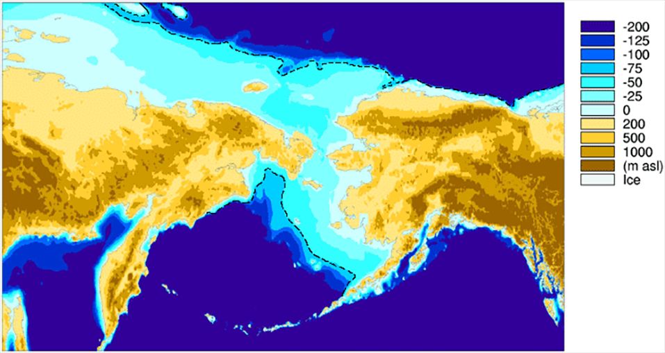
The Bering Land Bridge
The timing of the Bering Land Bridge between Asia and North America has implications for the migration of mammals and man that left the Ark and crossed to North America. The shallow Bering Strait is only about 50–55 m deep and the continental shelf off Siberia is very wide. Figure 5 shows the area that would be exposed if sea level were 75 m lower than today, or the area tectonically raised 75 m. The Bering Land Bridge would have been exposed at the peak of the Ice Age due to low sea level, but by that time winters would be turning bitterly cold with permafrost and bogs developing.
We assume that the animals spread around the world before man, who spent over 100 years in the Tigris/Euphrates region before spreading. Did the animals spread across the land bridge early in the Ice Age? They would have then continued to migrate down the ice-free corridor through Alberta, Canada, and Montana into the United States or along the coast from south-east Alaska to Washington state and then into Central and South America. There would have been little or no permafrost or bogs, and winter temperatures would have been much warmer in Siberia than today early in the Ice Age. Nothing would have impeded their progress.
It is likely the animals arrived early in the Ice Age and well before people, since abundant animal fossils are found in Pleistocene sediments in the Americas. Even some animals that could not tolerate much cold found their way to the Americas and may have passed through the Bering Land Bridge early in the Ice Age. An alternative method of migrating to the Americas would have been rafting on log mats.38 Was the Bering Land Bridge tectonically uplifted early in the Ice Age?
It is interesting that uniformitarian scientists believe the Bering Land Bridge was dry before about 4.5 Ma in the Early Pliocene.65,66 If the Flood/post-Flood boundary was just below the Pliocene Gubik Formation in Alaska, this would support the idea that this area was tectonically uplifted and exposed early in the Ice Age, despite high global sea levels. There are Pacific fossils in the lower Gubik Formation, which implies the Bering Strait was open for part of the deposition of this formation, which is mostly marine. However, some uniformitarians believe the Bering Land Bridge existed since the mid Cretaceous ,67 with the closing date of the land bridge, at about 3 Ma, likely determined by the need to account for the similar fossils on Eurasia and North America.49 Evidence is currently lacking for the early Ice Age exposure of the Bering Land Bridge and more research is needed.
Summary
The Arctic coastal plain sediments of North America are difficult to classify as to whether they are Flood, post-Flood, or both. Based on criteria developed for locating the Flood/post-Flood boundary, and despite some contrary evidence, the most significant evidence points to the boundary being above the Beaufort Formation of Canada and below the Gubik Formation of Alaska. These boundary designations remain tentative. This is one example where the boundary locations are equivocal, assuming the geological column for sake of reference.
References and notes
- Oard, M.J., The Flood/Post-Flood Boundary is in the Late Cenozoic with Little Post-Flood Catastrophism, michael.oards.net/PostFloodBoundary.htm, 2014. Return to text.
- Oard, M.J., Flood processes into the late Cenozoic: part 2—sedimentary rock evidence, J. Creation 30(2):67–75, 2016. Return to text.
- Oard, M.J., Flood processes into the late Cenozoic: part 3—organic evidences, J. Creation 31(1):51–57, 2017. Return to text.
- Oard, M.J., Flood processes into the late Cenozoic: part 4—tectonic evidence, J. Creation 31(1):58–65, 2017. Return to text.
- Oard, M.J., Flood processes into the late Cenozoic: part 5—geomorphological evidence, J. Creation 32(2):70–78, 2018. Return to text.
- Oard, M.J., Were the Wind River terraces caused by multiple glaciations? CRSQ 50(3):154–171, 2014. Return to text.
- Oard, M.J., Relating the Lava Creek ash to the post-Flood boundary, J. Creation 28(1):104–113, 2014. Return to text.
- Archer, M., Hand, S.J., and Godthelp, H., Riversleigh: The story of animals in ancient rainforests of inland Australia, Reed Books, New South Wales, Australia, 1991. Return to text.
- Oard, M.J., Frozen in Time: Woolly mammoths, the Ice Age, and the biblical key to their secrets, Master Books, Green Forest, AR, 2004. Return to text.
- Reed, J. K., Kulikovsky, A.S., and Oard, M.J., Can recolonization explain the rock record? CRSQ 46(1):27–39, 2009. Return to text.
- Granz, A., Johnson, L., and Sweeney, J.F. (Eds.), The Arctic Ocean Region: The geology of North America, Volume L, Geological Society of America, Boulder, CO, 1990. Return to text.
- Salzmann, U., Williams, M., Haywood, A.M., Johnson, A.L.A., Kender, S., and Zalasiewicz, J., Climate and environment of the Pliocene warm world, Palaeogeography, Palaeoclimatology, Palaeoecology 309:1–8, 2011. Return to text.
- Salzmann et al., ref. 12, p. 5. Return to text.
- Csank, A.Z., Tripati, A.K., Patterson, W.P., Eagle, R.A., Rybczynski, N., Ballantyne, A.P., and Eiler, J.M., Estimates of Arctic land surface temperatures during the Early Pliocene from two novel proxies, Earth and Planetary Science Letters 304:291–299, 2011. Return to text.
- Salzmann et al., ref. 12, p. 4. Return to text.
- Brigham-Grette, J., et al., Pliocene warmth, polar amplification, and stepped Pleistocene cooling recorded in NE Arctic Russia, Science 340:1421–1427, 2013. Return to text.
- Ballantyne, A.P., Greenwood, D.R., Sinninghe Damsté. J.S., Csank, A.Z., Eberle, J.J., and Rybczynski, N., Significantly warmer Arctic surface temperatures during the Pliocene indicated by multiple independent proxies, Geology 38(7):603–606, 2010. Return to text.
- Ballantyne, A.P., Rybczynski, N., Baker, P.A., Harington, C.R., and White, D., Pliocene Arctic temperature constraints from the growth rings and isotopic composition of fossil larch, Palaeogeography, Palaeoclimatology, Palaeoecology 242:188–200, 2006. Return to text.
- Pagani, M., Liu, Z., LaRiviere, J., and Ravelo, A.C., High Earth-system climate sensitivity determined from Pliocene carbon dioxide concentrations, Nature Geoscience 3:27–30, 2010. Return to text.
- Rybczynski, N., Gosse, J.C., Harington, C.R., Wogelius, R.A., Hidy, A.J., and Buckley, M., Mid-Pliocene warm-period deposits in the High Arctic yield insight into camel evolution, Nature Communications 4:1–9, 2013. Return to text.
- Salzmann et al., ref. 12, p. 2. Return to text.
- Wayman, E., Forests once covered Arctic, Science News 183(12):13, 2013. Return to text.
- Fedorov, A.V., Dekens, P.S., McCarthy, M., Ravelo, A.C., deMonocal, P.B., Barreiro, M., Pacanowski, R.C., and Philander, S.G., The Pliocene paradox (mechanisms for a permanent El Niño), Science 312:1485–1489, 2006. Return to text.
- Fedorov, A.V., Brierley, C.M., Lawrence, K.T., Liu, Z., Dekens, P.S., and Ravelo, A.C., Patterns and mechanisms of Early Pliocene warmth, Nature 496:43–49, 2013. Return to text.
- Pagani, M., Broken tropical thermostats, Nature Geoscience 7:555–556, 2014. Return to text.
- O’Brien, C.L., Foster, G.L., Martinez-Boti, M.A., Abell, R., Rae, J.W.B., and Pancost, R.D., High sea surface temperatures in tropical warm pools during the Pliocene, Nature Geoscience 7:606–611, 2014. Return to text.
- Marincovich, Jr., L., Brouwers, E.M., Hopkins, D.M., and McKenna, M.C., Late Mesozoic and Cenozoic paleogeographic and paleoclimatic history of the Arctic Ocean Basin, based on shallow-water marine faunas and terrestrial vertebrates; in: Granz, A., Johnson, L., and Sweeney, J.F. (Eds.), The Arctic Ocean Region: The geology of North America, vol. L, Geological Society of America, Boulder, CO, p. 414, 1990. Return to text.
- Riediger, C.L., Bustin, R.M., and Rouse, G.E., New evidence for the chronology of the Eurekan Orogeny from south-central Ellesmere Island, Canadian J. Earth Science 21:1286–1295, 1984. Return to text.
- West, R.M., Dawson, M.R., Hickey, L.J., and Miall, A.D., Upper Cretaceous and Paleogene sedimentary rocks, eastern Canadian Arctic and related North Atlantic areas; in: Kerr, J.W. and Fergusson, A.J. (Eds.), Geology of the North Atlantic Borderlands, Canadian Society of Petroleum Geologists, Memoir 7, p. 295, 1981. Return to text.
- Riediger, C.L. and Bustin, R.M., The Eureka Sound Formation, southern Ellesmere Island, Bulletin of Canadian Petroleum Geology 35(2):123–142, 1987. Return to text.
- Bustin, R.M., Beaufort Formation, eastern Axel Heiberg Island, Canadian Arctic Archipelago, Bulletin of Canadian Petroleum Geology 30(2):140–149, 1982. Return to text.
- Ricketts, B.D., Sedimentation, Eurekan tectonism and the fossil forest succession on eastern Axel Heiberg Island, Canadian Arctic Archipelago; in: Christie, R.L. and McMillan, N.J. (Eds.), Tertiary fossil forests of the Geodetic Hills, Axel Heiberg Island, Arctic Archipelago, Geological Survey of Canada, bulletin 403, pp. 1–27, 1991. Return to text.
- Riediger et al., ref. 28, p. 1288. Return to text.
- Christie, R.L. and McMillan, N.J. (Eds.), Tertiary fossil forests of the Geodetic Hills, Axel Heiberg Island, Arctic Archipelago, Geological Survey of Canada, bulletin 403, 1991. Return to text.
- Oard, M.J., Mid and high latitude flora deposited in the Genesis Flood—Part II: a creationist hypothesis, Creation Research Society Quarterly 32(3):138–142, 1995. Return to text.
- Oard, M.J., Cold oxygen isotope values add to the mystery of warm climate wood in NE Canada, J. Creation 17(1):3–5, 2003. Return to text.
- Obst, J.R. et al., Characterization of Canadian Arctic fossil woods; in: Christie, R.L. and McMillan, N.J. (Eds.), Tertiary fossil forests of the Geodetic Hills, Axel Heiberg Island, Arctic Archipelago, Geological Survey of Canada, bulletin 403, pp. 123–146, 1991. Return to text.
- Oard, M.J., The Genesis Flood and Floating Log Mats: Solving geological riddles, Creation Book Publishers, Powder Springs, GA. 2014. Return to text.
- Fyles, J.G., Beaufort Formation (late Tertiary) as seen from Prince Patrick Island, Arctic Canada, Arctic 43(4):393–403, 1990. Return to text.
- Devaney, J.R., Clastic sedimentology of the Beaufort Formation, Prince Patrick Island, Canadian Arctic islands: Late Tertiary sandy braided river deposits with woody detritus beds, Arctic 44(3):206–216, 1991. Return to text.
- Davies, N.S., Gosse, J.C., and Rybczynski, N., Cross-bedded woody debris from a Pliocene forested river system in the High Arctic: Beaufort Formation, Meighen Island, Canada, J. Sedimentary Research 84:19–25, 2014. Return to text.
- Fyles, J.G., Matthews, Jr., J.V., Barendregt, R., Baker, J., Irving, E., and Jetté, H., Ballast Brook and Beaufort Formations (late Tertiary) on northern Banks Island, Arctic Canada, Quaternary International 22/23:141–171, 1994. Return to text.
- Williams, C.J., Mendell, E.K., Murphy, J., Court, W.M., Johnson, A.H., and Richter, S.L., Paleoenvironmental reconstruction of a Middle Miocene forest from the western Canadian Arctic, Palaeogeography, Palaeoclimatology, Palaeoecology 261:160–176, 2008. Return to text.
- Matthews, Jr., J.V., Plant macrofossils from the Neogene Beaufort Formation on Banks and Meighen islands, District of Franklin, Geological Survey of Canada, paper 87–1A, pp. 73–87, 1987. Return to text.
- Matthews, R., J.V. and Fyles, J.G., Late Tertiary plant and arthropod fossils from the high-terrace sediments on Fosheim Peninsula, Ellesmere Island, Nunavut, Geological Survey of Canada, bulletin 529, 2000. Return to text.
- Tedford, R.H. and Harington, C.R., An Arctic mammal fauna from the Early Pliocene of North America, Nature 425:388–390, 2003. Return to text.
- Murray, A.M., Cumbaa, S.L., Harington, C.R., Smith, G.R., and Rybczynski, N., Early Pliocene fish remains from Arctic Canada support a pre-Pleistocene dispersal of percids (Teleostei: Perciformes), Canadian J. Earth Sciences 46:557–570, 2009. Return to text.
- Rybczynski, N., Woodcutting behavior in beavers (Castoridae, Rodentia): estimating ecological performance in a modern and a fossil taxon, Paleobiology 34(3):389–402, 2008. Return to text.
- Hulbert, R.C. and Harington, C.R., An Early Pliocene hipparionine horse from the Canadian Arctic, Palaeontology 42(6):1017–1025, 1999. Return to text.
- Dixon, J. and Dietrich, J.R., Canadian Beaufort Sea and adjacent land areas; in: Granz, A., Johnson, L., and Sweeney, J.F. (Eds.), The Arctic Ocean Region: The geology of North America, Volume L, Geological Society of America, Boulder, CO, p. 240, 1990. Return to text.
- Trettin, H.P., The Arctic Islands; in: Balley, A.W. and Palmer, A.R. (Eds.), The Geology of North America—An overview, Geological Society of America, Boulder, CO, pp. 349–369, 1989. Return to text.
- Oard, M.J., Flood by Design: Receding water shapes the earth’s surface, Master Books, Green Forest, AR, 2008. Return to text.
- Oard, M.J., Earth’s Surface Shaped by Genesis Flood Runoff, (ebook), Michael. oards.net/GenesisFloodRunoff.htm, 2013. Return to text.
- Granz, A., May, S.D., and Hart, P.E., Geology of the Arctic continental margin of Alaska; in: Granz, A., Johnson, L., and Sweeney, J.F. (Eds.), The Arctic Ocean Region: The geology of North America, vol. L, Geological Society of America, Boulder, CO, p. 264, 1990. Return to text.
- Dinter, D.A., Carter, L.D., and Bringham-Grette, J., Late Cenozoic geological evolution of the Alaskan North Slope and adjacent continental shelves; in: Granz, A., Johnson, L., and Sweeney, J.F. (Eds.), The Arctic Ocean Region: The geology of North America, vol. L, Geological Society of America, Boulder, CO, pp. 450–490, 1990. Return to text.
- Moore, T.E., Wallace, W.K., Bird, K.J., Karl, S.M., Mull, C.G., and Dillon, J.T., The geology of northern Alaska; in: Plafker, G. and Berg, H.C. (Eds.), The Geology of Alaska: The geology of North America, vol. G-1, Geological Society of America, Boulder, CO, pp. 49–140, 1994. Return to text.
- Bringham-Grette, J. and Carter, L.D., Pliocene marine transgressions of northern Alaska: circumarctic correlations and paleoclimatic interpretations, Arctic 45(1):74–89, 1992. Return to text.
- Bringham-Grette, J. and Hopkins, D.M., Emergent marine record and paleoclimate of the last interglaciation along the northwest Alaskan coast, Quaternary Research 43:159–173, 1995. Return to text.
- Dinter et al., ref. 55, p. 460. Return to text.
- Brouwers, E.M., Late Pliocene paleoecologic reconstructions based on ostracode assemblages from the Sagavanirktok and Gubik Formations, Alaskan North Slope, Arctic 47(1):16–33, 1994. Return to text.
- Carter, L.D., Brigham-Grette, J., Marincovich, Jr., L., Pease, V.L., and Hillhouse, J.W., Late Cenozoic Arctic Ocean sea ice and terrestrial paleoclimate, Geology 14:675–678, 1986. Return to text.
- Repenning, C.A., New evidence for the age of the Gubik Formation Alaskan North Slope, Quaternary Research 19:356–372, 1983. Return to text.
- McNeil, D.H., Tertiary marine events of the Beaufort-Mackenzie Basin and correlation of Oligocene to Pliocene marine outcrops in Arctic North America, Arctic 43(4):302, 1990. Return to text.
- Pillans, B. and Gibbard, P., The Quaternary period; in: Gradstein, F.M., Ogg, J.G., Schmitz, M.D., and Ogg, G.M. (Eds.), The Geologic Time Scale 2012, vol. 2, pp. 979–1010, 2012. Return to text.
- Marincovich Jr, L. and Gladenkov, A.Y., Evidence for an early opening of the Bering Strait, Nature 397:149–151, 1999. Return to text.
- De Schepper, S., Schreck, M., Beck, K.M., Matthiessen, J., Fahl, K., and Mangerud, G., Early Pliocene onset of modern Nordic Seas circulation related to ocean gateway changes, Nature Communications 6(8659):1–8, 2015. Return to text.
- Repenning, C.A. and Brouwers, E.M., Late Pliocene-early Pleistocene ecologic changes in the Arctic Ocean borderland, U.S. Geological Survey, bulletin 2036, Washington, D.C., 1992. Return to text.


Readers’ comments
Comments are automatically closed 14 days after publication.