

Journal of Creation 23(3):76–83, December 2009
Browse our latest digital issue Subscribe
Young evidences in an ancient landscape: part 1—the Eastern Structural Front of the Appalachian Mountains

The Appalachian Mountains of North America are traditionally considered to be the eroded roots of their original “Himalaya” size. The original heights are thought to have been erased by hundreds of millions of years of erosion resulting in the current rounded mountaintops, sediment filled valleys and rolling hills. Observations made along the Eastern Structural Front reveal categories of evidence that contradicts the idea of great age. The Appalachians are better explained as young formations created by recent catastrophic processes.
The Appalachian Mountains near the East coast of North America trend from Maine to Alabama along a northeast/ southwest axis for over a thousand kilometers (shown partially in figure 1). They are traditionally considered to be the remnant roots of their original “Himalaya” size heaped up by island arcs and tectonic plates, at different times.1 Richard Fortey writes: “Hundreds of millions of years of erosion had brought them down, exposing their innards to the snows and rains of the twenty-first century …. Geological time is enough to wear down the mightiest peaks, and lay low former Everests.”2
There is a distinct edge of these mountains roughly paralleling the North Atlantic coast of the United States which we will call the “Eastern Structural Front” (also known in Pennsylvania as the “Blue Mountain Structural Front”).3 The Eastern Structural Front traces the southeast edge of the Appalachians. This paper focuses on observations made along the 440-km-long northern section of the Eastern Structural Front located in Pennsylvania, northern New Jersey and southern New York State.

The Appalachians are made up of thick sequences of sedimentary deposits, often uplifted and deformed. This contrasts sharply with the terrain east of the Structural Front which contains large amounts of igneous and metamorphic material in addition to lesser amounts of sedimentary deposits.
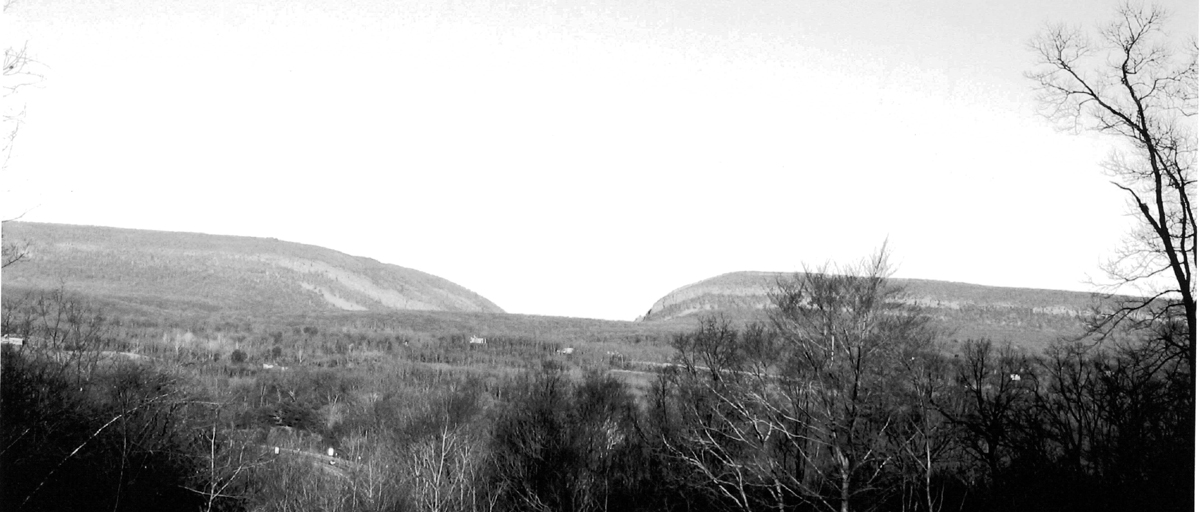
Less than 100 km to the east, the major cities of New York and Philadelphia lie mostly on igneous rock. The Eastern Structural Front of the Appalachians is marked by a distinct and prominent raised ridge. The continuity of this impressive feature—just an hour’s drive from New York City near its north end—is concealed to many by the local names applied to the ridge as it passes through different political boundaries. From northeast to southwest these names include the Shawangunks, Kittatiny and Blue Mountain.4
It maintains considerable uniformity in height and slender width compared to its extreme length. It extends 1,000 km from New York State to Alabama in sharp relief. Close to 400 m above sea level (ASL), the steepest grades on the southeast face average 50% (table 1). We will see later that this horizontal strip represents the eroded face of a rock sequence that, although highly tilted, maintains a horizontal deviation of less than one tenth of one percent over the 400 km length studied.5
Talus slopes
The Eastern Structural Front is penetrated by four prominent water gaps in our study area. One of these, the Delaware Water Gap, has large, non-vegetated, talus slopes flanking either side (figure 2). Interstate Highway 80 squeezes through the Delaware Water Gap. The rock fences constructed along the highway provide evidence that this talus slope resides at its maximum angle of repose and is being refreshed with new material dropping from above.

Debris fields of stone fragments can be found in many locations along the southeast side of the Eastern Structural Front, not just at the Delaware Water Gap. The scree tends to hang up around the 320–340-m elevation (figures 2 and 4) having eroded from the exposed rock face above. The talus accumulates at the transition from the steepest grades to the lesser slopes below. It is thought that this upper rock face forms the erosion resistant capstone that preserves the high ridge elevation while the surrounding soft materials have eroded away over long time periods. However, if a long time period has passed, a dilemma is created by the following observations:
- The talus slopes reside at their maximum angle of repose in many places.
- The accumulated scree is devoid of vegetation in locations distributed along the entire structural front.
The maximum angle of repose suggests continual renewal from eroding capstone and, although talus slopes are commonly devoid of vegetation, pockets of bare scree are not expected in the northeastern United States where the climate promotes lush growth. Vegetation rapidly colonizes any surface with even the slightest accumulation of soil. The maximum angle of repose and the lack of vegetation are evidences that the talus slopes are young.
If we assume that freeze-thaw cycling and natural weathering is causing the fresh scree deposits, we run in to a time problem at both the top of the ridge and in the valley. The erosion of the cliff face would quickly decrease the ridge elevation because the rock layers are uplifted at an approximate 40° angle (figure 3). As the cliff face erodes back from the enlarging scree pile, the distinct profile of each would gradually merge into a long easy slope—yet the Front has a steep profile up to a fairly uniform crest that persists for hundreds of kilometers to the northeast and southwest (table 1). The remnant roots of a former Himalayan sized mountain range should not have fresh cliff faces and steep talus slopes.
To demonstrate this concept, assume a vertical cliff 500 m high formed by 45° strata with the strata eroding back into itself at the rate of only 1 cm per year. Assume all the eroded material is removed from the bottom by some undefined process. This would result in the loss of one meter of elevation every 142 years, and the complete erosion of the cliff in 71,000 years.
If we let the scree accumulate, the profile would convert into a sloped hillside in half that time. The erosion of the rock face over any appreciable length of time will drastically reduce the ridge height. However, we observe a very uniform ridge height with a very uniform exposed and eroding rock face (figure 2). Even over relatively short periods, we would expect to see a jagged ridgeline or no ridge at all. If this weathering has been of long duration, the talus slopes would fill themselves in and flatten. Further, if this weathering has been of long duration we would expect soils to form and the slopes to be fully vegetated.
Water gaps
In addition to the Delaware Water Gap, the Eastern Structural Front is interrupted by three other significant water gaps and several smaller ones. These water gaps are striking in their V-shaped profile—having high angle sides that interrupt the monotonous horizontal profile of the Eastern Structural Front.

The widest water gap is formed by the Susquehanna River. Because of this water gap, the Susquehanna is considered among the oldest rivers in the world, pre-dating the opening of the Atlantic Ocean.6 The spectacular profile of the worldclass Susquehanna River Water Gap exemplifies the difficulty in applying the superposition river theory which requires downward erosion over long periods of time exactly matching the uplifting of the ridge and the eroding away of the softer surrounding materials.7
The Susquehanna not only formed the largest water gap through the Eastern Structural Front, but four additional gaps are found in quick succession just upstream and within 37 km of each other (the final two gaps can be seen in figure 8).
This is truly spectacular, especially when you consider that the second and third gaps are only 12 km from a clear and level path around the end of the obstructing ridges. Yet 50 km further upstream it faithfully follows along the side of a lesser anticline, indicating that “Regional superposition is further invalidated by the fact that Appalachian drainage is by no means completely independent of structural or lithologic control.”8
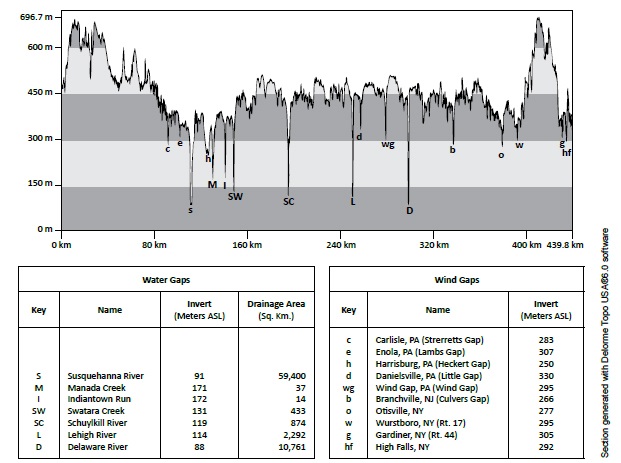
Figure 5 shows the relative positions and heights of all of the water and wind gaps in our study area. The two largest water gaps (Susquehanna and Delaware) share bottom elevations (inverts) and side slopes that are remarkably similar even though the drainage areas are quite different.
The two smaller water gaps (Lehigh and Schuylkill) drain relatively small areas. The Lehigh and Schuylkill have virtually identical water gaps, both in shape, grade and absolute bottom elevation (figure 6). All four gaps have similar steep-wall profiles. These observations require explanation when the following correlations are considered:
- The Schuylkill and Lehigh drainage basins upstream of the gaps vary in size by a factor of three.
- The Schuylkill and Lehigh drainage basin areas upstream of the gaps are less than 4% of the size of the Susquehanna River basin and are approximately a fifth of the size of the Delaware River drainage basin.
- The Schuylkill and Lehigh drainage basin areas are insignificant compared to the Delaware and Susquehanna basins, yet exhibit the same steep-walled profiles on their respective water gaps.
The superposition river theory supposes these rivers flowed along the top of a hypothetical surface above the folded Appalachians, cutting down and removing the softer material while cutting only small gaps through the erosion resistant ridges which still remain. This explains how the river ignored what looks today like an impenetrable wall by slowly eroding all of the surrounding sediments until the present low river valleys easily flow through the gap that was formed over millions of years. The stark relief of the ridge was supposedly maintained over the same millions of year’s time event by erosion resistant rock at the cap.

There are problems with this explanation including:
- The gap profiles have steep sides. The long process that carved out all the valleys, removing vast quantities of abrasive sediments, did not flatten or polish down the steep sides of the gap, even though the energy of the flow was concentrated at this point.
- The rivers do not completely ignore the ridges, but faithfully run parallel with ridges in other locations.
Let us consider a simple variation of the superposition river theory: that the ancient river did not start by running along the top of an erosion surface, but as a current in a fully inundated landscape. This current would be slightly influenced by the appearance of the first “islands” of sediment that would appear as either the water level lowered, or the sedimentary deposits raised through deformation or rebound. The first appearance of land would cause the currents to run between the widely spaced islands. As the land became higher and/or the water elevation lowered, the resulting “islands” would channelize the currents into directional flows. As the hydraulic gradients increased between the upland waters that were becoming restrained and the lowering oceanic sea level, the vast potential energy of the upland water would quickly erode gaps at the limited discharge points. This process of sheet flow becoming channelized flow has been put forth as a deduced observation in many locations.9
Wind gaps
There are higher gaps along the Eastern Structural Front, commonly called “wind gaps” because there is no active watercourse running through them (figure 5). Wind gaps are thought to be remnant water gaps from abandoned stream courses.10 These previous water gaps were left high and dry when the paleoriver changed its direction to one of the present drainage basins.

Image generated by Google Earth™ on 17 March 2006

There are many wind gaps throughout the Appalachians with indications of abandoned river channels, but there is no topography at any of these notches in the Eastern Structural Front to suggest the possible course of an abandoned stream of any size or length.
If we use the hypothesis that the Eastern Structural Front acted as a large dam during a catastrophic inundation, the idea of an ancient river coursing along the top of a plain of sediment is replaced by an ancient current running along the top of an inland sea. If this hypothesis is correct, then the lowest elevations at each wind gap represent a level at which the hydraulic differential across the gap reduced enough to stop further down cutting.
The receding water behind the gap would eventually drain through one of the other, still deepening, gaps. The wind gaps exhibit a preference of bottoming near the 265–305-m elevation, while all the major water gaps extend 150– 200 m deeper. Are these random preferences or do they evidence a creating force that worked within horizontal boundaries?
Figure 7 traces the 320-m elevation and clearly depicts the Eastern Structural Front acting as a dam or barrier island. This contour represents an elevation just above where the gap on the lower right of figure 7 (Wind Gap, PA) closed.
It is interesting to note that this elevation roughly correlates in many locations with the bottom of the steepest slopes (table 1) on the southeast face of the Eastern Structural Front (highlighted by the scree accumulation line visible in figure 4). It is also near this elevation that the remnant valleys seen in figure 9 bottom out.
These correlations are consistent with the possibility that a shoreline once paused near this elevation. A temporarily perched shoreline would allow the water elevations on either side of the Front to equalize, temporarily halting the deepening of the gaps and allowing the slope on the “ocean” side of the Front to become less severe. The line of talus seen in figure 4 is highlighting the slope change.

Incised meanders and rapids
Whitcomb and Morris pointed out that incised river meanders are evidence of rapid high energy down cutting.11 Low discharge rates cut horizontally, not vertically,12 resulting in a river profile of gently sloping flood plains, not canyons. The Lehigh River, which has a pronounced water gap (figure 6), is also characterized by a deeply incised channel despite its relatively small drainage basin. Its deep valley contains rapids suitable for white water rafting during times of high flow.13 This river has not been able to erase its rapids just 25 km upstream of its major water gap through the Eastern Structural Front, which is evidence of recent formation.
The drainage divides between the four major water gap rivers (Susquehanna, Schuylkill, Lehigh and Delaware) are found at the relatively low elevation of 240 m. Therefore, total inundation would allow all four water gaps to form simultaneously from the same water source all the way down to 240 m above sea level. Their gap profiles and bottom elevations would have to be in close alignment if they were cut simultaneously with the same energy source until the final stage of run-off. The underfit Lehigh River and Schuylkill River have gorges and gaps not well explained by their small drainage basins. The Delaware and Susquehanna gaps also share similar, but lower, inverts fed by much larger modern drainage basins. An inundation scenario provides the same (very large) water supply to all four water gaps until their final stage of down cutting.

Figure 8 shows lines of minor rapids in the Susquehanna River. The bottom profile of the Susquehanna River is wide, flat and shallow—not sediment filled, U- or V- shaped. Erosion of the river bottom is restrained by horizontal lines of upturned rock across the river in perfect alignment with the angle of the upturned strata forming the adjoining high ridges to the right and left. This river is supposed to have been down cutting for 300,000,000 years in perfect balance with the uplifting of the topography and/or the erosion of the valleys. Yet we find sharp, horizontal and linear rock extending fully across every one of the five steep walled water gaps the Susquehanna runs through at the Eastern Structural Front. This most ancient of rivers still has rapids.
Remnant valleys
The steep walled canyons of the Lehigh River suggest rapid down cutting. Rapid down cutting could be caused by a differential in surface elevation between the impounded water on the uphill (northwest) side discharging into the valley that runs continuously behind the Eastern Structural Front. Along the northwest face of this valley we observe additional canyonlike valleys just northeast of the Lehigh River discharge point. These valleys have some similarities to the sidewall canyons observed along the Colorado River at the Grand Canyon.14 Running along the bottom of figure 9 fairly sizable “canyons” are visible that formed on the northwest wall of the larger valley that runs along the back of the Eastern Structural Front. These “canyons” have no present external source of water to explain their formation. However, this is the location where the source of water for the still forming Lehigh River would have overflowed if the Lehigh River Valley did not yet exist. Figure 10 maps the extent of the contributory drainage area to the valleys as they exist today. It is evident that each of these drainage basins consists mostly of the valley itself and could not have formed by the small quantity of present run-off.
If we examine these valleys under the scenario of a rapid runoff from complete inundation, a mechanism exists to explain their formation. Figure 11 traces the contours at the approximate elevations, based on present conditions, where the sheet runoff from a receding inundation would be forced in to channelized run-off.
There is a limited time when the water elevation reduces from overtopping the area around these valleys, and channelizes into the present Lehigh River Gorge several kilometers to the west. The impounded water that drained over this last obstacle would quickly cut these valleys and then be cut-off, leaving these valleys dry. Hydraulic sapping could have further enlarged these valleys as the ground water in supersaturated sediment seeped.15


Therefore, these “remnant” valleys provide strong evidence of catastrophic landscape formation. Their depth may demonstrate the hydraulic gradient that briefly existed between the uphill reservoir to the northwest and the relief point to the southeast. The overtopping sheet flow that carved these valleys would not cut down much below the downstream water elevation. These valleys bottom at about the 320-m elevation. This elevation, as noted earlier, reveals itself again as a possible temporary sea level during the recessional stage of the inundation. The erosion energy needed to form these remnant valleys would have only been available for the relatively brief time period between the 480–490-m elevation upper water level and the 460-m elevation level when flow would have been cut off. Sea level would have needed to simultaneously drop to an elevation near 320 m to allow the valleys to cut down to their present depth.
Tracing the present 480-m elevation contour line— which marks the elevation at which sheet flow would be forced into channelized flow as more and more land emerged—reveals an escarpment through the Pocono Plateau. The still intact vertical sedimentary face of the escarpment should have eroded away if the landscape has great age (figure 12).16 Tracing the 320-m elevation contour line reveals a possible second escarpment, with a face heavily dendritically eroded.
Conclusion
Any mature landscape can contain fresh gullies, landslides and localized scars, but the eroding cliff faces, unvegetated talus and steep slopes examined by this paper extend over hundreds of kilometers. The Eastern Structural Front, a natural dam, maintains steep slopes, linear uniformity, “world class” water gaps that drain vastly different areas while displaying similar profiles and inverts, and wind gaps at uniform elevations. The uniformity of these features argues against them being random remnants of millions of years of erosion.
The horizontal alignment of ridges, slopes, inverts, and talus point to formation by a force that respects horizontality, such as water. Remnant valleys and high wind gaps with no apparent feeder streams suggest a lot of water at high elevations. Incised meanders and V-shaped gaps imply rapid formation. Unvegetated slopes, still eroding cliff faces, sliding talus and remnant valleys point to recent formation. The “ancient” landscape of the Appalachians contains categories of evidence suggesting youth.
Acknowledgments
The Google™ Earth aerial photography collection available on line allowed the rapid study of landforms from many angles at many scales. Many of the observations presented in this paper would not have been apparent without this technology.
References and notes
- For example in The Great Courses, Great Courses Taught by Great Professors, Spring 2008 Sale Issue Catalogue, “The Nature of Earth: An Introduction to Geology” by Professor John J. Renton, Ph.D., West Virginia University, p.13. Quote from the catalogue: “… have you ever driven in the rolling hills of the Piedmont region that extends from New Jersey to Alabama? Then you have crossed the core of an ancient mountain range that once rivaled the Himalayas. Now almost completely eroded away, these peaks were created 300 million years ago in the collision of tectonic plates that formed the supercontinent of Pangea.” Return to text.
- Fortey, R., Earth: An Intimate History, Vintage Books, New York, p. 179, 2004. Return to text.
- Faill, R.T. and Nickelsen, R.P., Structural geology and tectonics—Appalachian Mountain section of the Ridge and Valley Province; in: The Geology of Pennsylvania, Shultz, C.H. (Ed.), The Pennsylvania Geology Survey, Harrisburg, PA, and The Pittsburgh Geological Society, Pittsburgh, PA, p. 271, 2002; Figure 19–3. Return to text.
- Many of the mountain and river names in this region derive from the Native American languages present during the first European settlement of the East Coast of America in the sixteenth and seventeenth centuries. Return to text.
- Using the difference in the maximum top and minimum bottom elevation from table 1 divided by length or (640 m minus 260 m)/404 km (1000m/km) = 0.00094. If the formation’s thickness was subtracted and the average height used, the deviation would be less than half of this value. Return to text.
- Susquehanna River, en.wikipedia.org, accessed June 2009. Return to text.
- Oard, M., Flood by Design, Master Books, Green Forest, AR, p. 97, 2008. Return to text.
- Kaktins, U. and Delano, H.L., Drainage basins; in: The Geology of Pennsylvania, Shultz, C.H. (Ed.), The Pennsylvania Geology Survey, Harrisburg, PA, and the Pittsburgh Geological Society, Pittsburgh, PA, p. 382, 2002. Return to text.
- Oard, ref. 7, pp. 79–81. Return to text.
- Way, J.H., Physiography—Appalachian Mountain Section of the Ridge and Valley Province; in: The Geology of Pennsylvania, Shultz, C.H. (Ed.), The Pennsylvania Geology Survey, Harrisburg, PA, and the Pittsburgh Geological Society, Pittsburgh, PA., p. 360, 2002. Return to text.
- Whitcomb, J. and Morris, H., The Genesis Flood: The Biblical Record and its Scientific implications, Presbyterian and Reformed Publishing Company, Phillipsburg, NJ, pp. 154–155, 1961. Return to text.
- Austin, S., Grand Canyon: Monument to Catastrophe, Institute for Creation Research, Santee, CA, pp. 98–99, 1994. Return to text.
- For example, see whitewaterchallengers.com or poconowhitewater.com for tour information. Return to text.
- Austin, ref. 12, pp. 99–100. Return to text.
- Austin, ref. 12, figures 5.18 and 5.19, p. 100. Return to text.
- Oard, ref. 7, p. 54. Return to text.


Readers’ comments
Comments are automatically closed 14 days after publication.