

Submarine canyons bigger than Grand Canyon
Carved as Noah’s Floodwaters receded

Many have stood at the rim of Grand Canyon awed by its great depth and enormous size. Surprisingly, our Earth has other even larger canyons, but they are unseen since they lie underwater (fig. 1). These are submarine canyons that run away from the coast, sometimes starting close to shore. Submarine canyons are incredible landforms that point to the catastrophic impact of Noah’s Flood.
Submarine canyons differ from deep-sea trenches, like the Mariana Trench, the deepest place in the oceans. Trenches generally run parallel to the shoreline in deep water. Submarine canyons, in contrast, start in shallow water, generally on the continental shelf, and run perpendicular to the continental margin down into deep water. They were eroded by the channelized flow of the receding floodwaters.1
Submarine canyons differ from slope canyons, which are common.2 Slope canyons have an average spacing of 33 km (20 miles),3 and there are around 6,000 deeper than 100 m (330 ft). Nearly all slope canyons sit along the steep continental slope and are relatively small. Slope canyons formed in the 4,500-year post-Flood era as loose sediment built up at the edge of the continental shelf and periodically avalanched down the slope.
By way of contrast, hundreds of larger submarine canyons are carved into the flat continental shelf. These are often but not always found seaward of rivers. And these are the canyons that were eroded late in Noah’s Flood as the floodwaters were receding in narrow channels.
Submarine canyons are enormous
Submarine canyons on the continental shelf begin at ocean depths ranging from about a metre to more than 300 m (1,000 ft). The average is 100 m (330 ft) near the edge of the continental shelf. The large Capbreton Canyon, perpendicular to the French coast but running roughly parallel to the northern coast of Spain, begins only 250 m (800 ft) from the shore at a water depth of only 30 m (100 ft)!4 The Scripps Canyon off La Jolla, California, USA (which joins the La Jolla Canyon further off-shore) also starts close to the beach, so close in fact that if it continued to grow toward the shore, the Scripps Institute of Oceanography’s pier would collapse into the canyon.
The average length of a submarine canyon is over 50 km (30 miles). Sometimes the submarine canyon continues out over its deposits and forms a canyon on its submarine fan. If these fan valleys were included, submarine canyons would be much longer. For instance, Africa’s Congo Canyon would be 800 km (500 miles) long rather than 190 km (120 miles). The longest submarine canyon is the Bering Canyon (near the Aleutian Islands) with a total length of about 500 km (310 miles, which is longer than Grand Canyon), including a fan valley 95 km (60 miles) long.5
The depths of submarine canyons have attracted much attention. Some are deeper and wider than Grand Canyon. The wall height varies down a canyon, and the sides are rarely at the same depth. On average, the maximum height of the walls is about 900 m (3,000 ft)—greater than the average height of land canyons. The highest submarine canyon walls are in the Capbreton Canyon with a maximum height of 3,000 m (10,000 feet).6
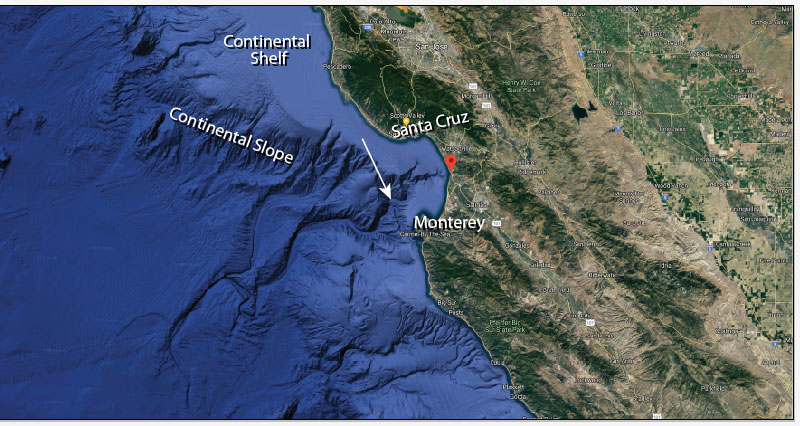
Monterey Canyon, California, is probably the most studied submarine canyon in the world (fig. 2). It starts in water 18 m (60 feet) deep near the pier at Moss Landing in Monterey Bay, and is 96 km (60 miles) long. Like so many other such canyons it continues onto its submarine fan fig. 3).
Including its fan valley, the total length of the canyon is about 470 km (300 miles). Its maximum wall height is 1,700 m (5,600 feet), and its maximum rim-to-rim width is 12 km (7.5 miles), similar to Grand Canyon.
Submarine canyons and coastal rivers

Interestingly, many continental shelf submarine canyons are found seaward of rivers, and many features of submarine canyons are similar to river valleys. Submarine canyons have tributaries, meanders, meander loops, and horseshoe-shaped meander cut-offs.7 So what caused these unique river-like features? Although the relationship between submarine canyons and rivers on land is significant, it does not support the idea that the canyons were formed directly by erosion by these rivers. There is no direct connection between the rivers and their nearby submarine canyons, either on the surface of the continental shelf or below the surface. The rivers end abruptly at the shoreline and the canyons start well offshore. And further, these features are usually found in deep water. In other words, the water level is too deep for the sea to have caused them. Whatever caused these features was the same process that carved the submarine canyons.
Long-age geologists have difficulties
Uniformitarian geologists generally say that the large submarine canyons were formed by repeated sliding of sediment down the continental slope, until it eventually reached up onto the continental shelf. But why would the sliding focus on one location, over and over again, greatly deepening one canyon instead of creating multiple mini-canyons? Lastras and others write:
“In spite of this large effort, a general world-wide accepted valid theoretical context of the location, evolution and activity of submarine canyons is not yet available.”8
Explained by Late Flood channelized erosion
The problem for uniformitarians/long-agers is they lack a process that would focus eroded sediment from the continents at one location on the continental shelf. The process would need to continually feed sediment to slide down into the deep ocean and progressively carve and enlarge a submarine canyon.
However, channelized erosion in the late Flood easily provides the large erosional energy required to form these underwater canyons. As the floodwater drained from the continents it channelized through the coastal areas forming valleys. The speed and erosion were so great that the sediment, rather than being dispersed along the coast, was deposited on the continental shelf seaward of the river valley. As the sediment accumulated here, it continually slid down the continental slope forming the submarine canyon. As sediment slides downslope it will accelerate to high speeds causing deep erosion.9
Figure 4 illustrates how this process formed submarine canyons on the continental shelf. It is important to appreciate that it is not the present-day river that is related to the submarine canyon, but the onshore valley. Today, the river flows through the valley only because it is convenient. Submarine canyons are one more example of the widespread body of evidence10,11that supports the reality of the biblical Flood.

References and notes
- Walker, T., A biblical geologic model; in: Walsh, R.E. (Ed.), Proceedings of the Third International Conference on Creationism, technical symposium sessions, Creation Science Fellowship, Pittsburgh, PA, pp. 581–592, 1994; biblicalgeology.net. Return to text.
- Pickering, K.T. et al., Deep-Marine Environments, Unwin Hyman, London, U.K., pp. 133–159, 1989. Return to text.
- Harris, P.T. and Whiteway, T., Global distribution of large submarine canyons: geomorphic differences between active and passive continental margins, Marine Geology 285:69–86, 2011. Return to text.
- Mulder, T. et al., Understanding continent-ocean sediment transfer, EOS, Transactions, American Geophysical Union 85 (27):257, 261–262, 2004. Return to text.
- Karl, H.A. et al., Aleutian basin of the Bering Sea: styles of sedimentation and canyon development; in: Gardner, J.V. et al., (Eds), Geology of the United States’ Seafloor—The View from GLORIA, Cambridge University Press, New York, NY, p. 305–332, 1996. Return to text.
- Green, H.G. et al., Physiography of the Monterey Bay National Marine Sanctuary and implications about continental margin development, Marine Geology 181:55–82, 2002. Return to text.
- Perkins, S., Hidden canyons: vast seabed chasms carved by riverlike processes, Science News 167:9–11, 2005. Return to text.
- Lastras, G. et al., Geomorphology and sedimentary features in the Central Portuguese submarine canyons, Western Iberian margin, Geomorphology 103 (3):310–329, 1 February 2009; quote on p. 311. Return to text.
- Mulder, T. and Alexander, J., The physical character of subaqueous sedimentary density flows and their deposits, Sedimentology 48:269–299, 2001. Return to text.
- Oard, M.J., Geomorphology provides multiple evidences for the global Flood, Creation 37(1):47–49, 2015. Return to text.
- Further information and references related to the series of articles on landforms presented in Creation magazine can be accessed at creation.com/landform-links. Return to text.
Readers’ comments
Comments are automatically closed 14 days after publication.