

Geomorphology provides multiple evidences for the global flood

Geomorphology is a subfield of geology which specializes in studying and explaining the shape of the earth’s surface—its mountain ranges, plateaus, and plains. It includes study of small-scale features such as hills, valleys, slopes, and canyons. The individual features of the landscape within the field of geomorphology are called landforms. Geomorphology is a ‘gold mine’ of evidence for the Genesis Flood.
Geomorphology—a major mystery for secular geology
Although we all see and enjoy the beauty of the mountains, rivers, and valleys of the earth, it is amazing how difficult it is for secular science to explain their origin.1 Their difficulty arises because they begin with an incorrect assumption about what happened in the past. They reject the biblical Flood and assume uniformitarianism, which insists the earth’s rocks, fossils, and surface features may only be explained using present slow-and-gradual processes over millions of years.
Elevated flat-topped landforms such as plateaus and mesas are no less difficult for the uniformitarian to explain. Secular scientists once thought it would be easy to understand the origin of landforms after they rejected the Genesis Flood. In 1909, William Morris Davis, who developed a popular idea for shaping landforms, confidently said:
“an essentially explanatory treatment must in the next century [20th century] be generally adopted in all branches of geographical study …”2
But, time did not help them. By 1974, C.H. Crickmay, a Canadian geomorphologist, was amazed that after all these years landforms still remained unexplained:
“The difficulty that now confronts the student [anyone who studies landforms] is that, though there are plenty of hypotheses of geomorphic evolution, there is not one that would not be rejected by any majority vote for all competent minds. This situation is in itself remarkable in a respectable department of science in the latter half of the 20th Century.”3
Crickmay is not alone in stating the dismal results of secular geomorphology: “… it became increasingly evident after 1960 that no satisfactory understanding of geomorphological processes existed …”4 (emphasis mine). From the standpoint of the history of science, this is an amazing admission, and the situation is much the same today.
Landforms that need explaining
1. Mountains
Despite being perhaps the most prominent landform on every continent, the origin of mountains is still unknown. Evolutionary geomorphologists Cliff Ollier and Colin Pain wrote a provocative book in 2000, The Origin of Mountains, listing 20 different mechanisms proposed for the uplift of mountains, none of which can be demonstrated.5
2. Planation surfaces
Elevated flat-topped landforms such as plateaus and mesas are no less difficult for the uniformitarian to explain. Many are erosional remnants shaped out of horizontal layers of sedimentary rocks. Others were carved into tilted sedimentary strata (figure 2). Evolutionary geomorphologists find it difficult to explain how flat-topped landforms with tilted strata are cut smoothly across alternating hard and soft sedimentary layers. The flat, table-like surface of the raised mesa or plateau does not vary with the hardness of the underlying rock. It should, if uniformitarianism were true. Usually, erosion is faster and more extensive on soft rocks than on hard ones. According to orthodox geomorphology, plateaus and mesas on tilted rocks should have a hilly, undulating top, with the harder rocks forming ridges and the softer rocks forming valleys.
These relatively flat, smooth surfaces are called planation or erosion surfaces.6 Planation surfaces are not forming today. Instead what we observe is their gradual destruction by erosion. So, the fact that they cover large areas of the earth defies uniformitarianism and suggests another mechanism.
3. Inselbergs
Inselbergs, another type of erosional remnant, are tall, steep-sided hills or mountains that sometimes stand alone in open plains, in appearance much like small islands rising from the sea. They can also be found in valleys or on the sides of mountains, or dotted over planation surfaces and pediments (see below).7 They can range from an isolated rock or spire to a small mountain. They are sometimes rounded or dome-shaped on top, not having the flat planation surfaces of mesas. These erosional remnants have been given a number of names, most commonly ‘inselberg’. Uluru/Ayers Rock in central Australia is probably the most famous inselberg (figure 4). They are usually said to be millions of years old, but if that were true they should have eroded down to nothing since vertical faces erode faster than horizontal surfaces.8

4. Pediments
Smooth, flat planation surfaces also commonly occur alongside mountains, ridges, or plateaus (figure 3). These are called pediments. They are gently sloping, nearly-flat surfaces of solid bedrock that have been carved by erosion and extend out from the base of the higher landforms, such as mountains or plateaus. They should not be confused with slopes of loose rocky debris (‘scree’ or alluvial fans), but are solid-rock surfaces. Like other landforms, pediments are not seen forming today; thus, the axiom of uniformitarianism again does not apply. What we observe is the opposite: pediments are being destroyed by erosion. For uniformitarian geologists, pediments are another mystery of geomorphology: “The curious and ubiquitous nature of this landform suite … has baffled geologists for over a century.”9
5. Hard, rounded rocks transported long distances
Another curious feature of pediments and planation surfaces is that they are often covered by a layer of hard, rounded rocks. These rock layers can also be found on plateaus and mountain tops (figure 5) as well as piled up thousands of metres thick in deep cracks on the earth’s surface. These rocks were clearly rounded and deposited by water.10 Some of the rounded rocks were transported long distances, more than 1,000 km from their sources, which is impossible to explain by the relatively weak size and power of today’s streams and rivers—even by local floods.
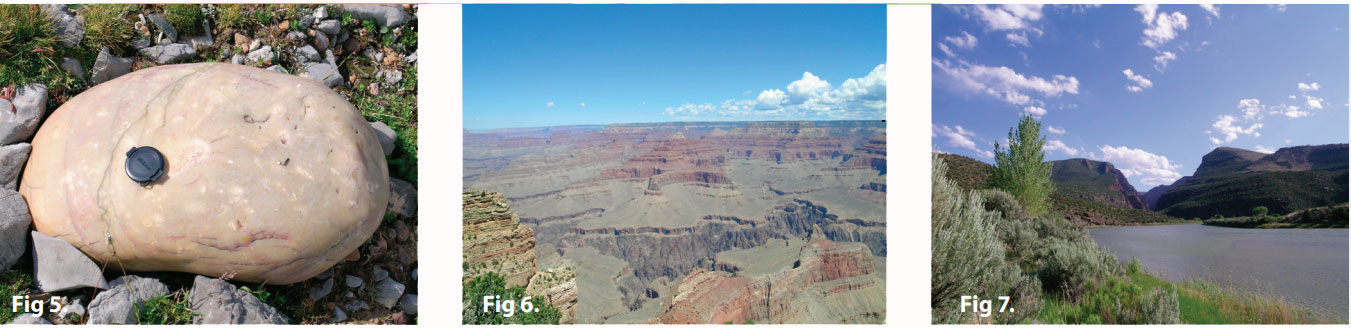
6. Gorges and water gaps
Another mystery for uniformitarian geology is that rivers and streams often flow in gorges—i.e. in narrow valleys with steep walls. These gorges can also be called canyons. The Grand Canyon is probably the most famous of these, and one of the deepest at 1,500 m (figure 6).11 When a river passes though mountains or plateaus in deep gorges, it is called a water gap (figure 7).12 A big problem for uniformitarian geomorphologists is that for a river to cut the Grand Canyon it would have had to flow uphill! To make the mystery more curious, many of these rivers appear to have chosen to flow through mountain barriers, when nearby there was an easy downhill path around the barrier. Geomorphologists have developed several hypotheses, but none is a good fit for the physical evidence as observed in the field.
7. Submarine geomorphology
The mysteries of geomorphology also continue under the ocean. The first concerns the very thick border of sedimentary rocks called the continental margin that surrounds every continent and even large islands. The margin consists of the flat, wide continental shelf and the continental slope that suddenly plunges down into the deep ocean basins. Geomorphologists are not sure how these aprons of sedimentary rock formed.
In some places, erosional canyons have cut through the continental margin. The deepest submarine canyons usually originate on the continental shelf, and run at right angles away from the continents (figure 1, p. 47). They can be thousands of metres deep and hundreds of kilometres long. Some are deeper than Grand Canyon. As with the other features of the continental margins, secular geomorphologists have difficulty explaining them.
Flood runoff can explain landforms
The Genesis Flood clears up these apparent mysteries. The majority of the erosion and deposition of the earth’s surface took place during the runoff of the Flood water, when the mountains and continents rose and the ocean basins sank. The water first flowed as wide currents during the Abative Phase.13 Then as more mountains and plateaus were exposed above the Flood water, the water was forced to channelize around these obstacles. This later phase is called the Dispersive Phase.
Erosion beyond anything we can imagine today scoured the earth during the Flood runoff.14 Landforms were first carved by the wide flows of the Abative Phase and then by the channelized flows of the Dispersive Phase. Rapidly-flowing, wide currents planed the surface flat and deposited hard, rounded rocks that were transported hundreds of kilometres from their source. Plateaus and mesas were created in two stages: first, the top sediments were planed flat by sheet flow. Then lower, channelized flow cut away surrounding sediments as the continents rose relative to sea level, and the ocean basins sank, causing the water level to drop. These landform remnants were thus isolated, and left with steep sides. Occasionally, tall inselbergs were spared from destruction, leaving them dotted over some planation surfaces. The eroded debris was swept off the continents and deposited where the currents slowed—in deep water at the continent margin, forming the continental shelf and slope.
As the water became more channelized in the Dispersive Phase, valleys and vertically-walled canyons were rapidly carved. Some of these gorges cut down through rock that was soon to form mountain ranges, ridges, and plateaus. This explains how water gaps are often found today cutting through mountains and other high areas—in ways that make no sense to uniformitarian geomorphologists. Of course, in normal rivers and streams today, water always takes the easiest course—it never flows into mountains, but flows around them.
Rapid, channelized currents flowed down valleys forming wide, flat pediments, capping them with rounded rocks. The channelized currents did not stop as they exited the continents, but were strong enough to cut deep submarine canyons into the newly deposited sediments on the continental margin.
The Genesis Flood explains the ‘mysteries’ of geomorphology as we have discussed above. And these ‘mysterious’ landforms are found worldwide, providing powerful confirmation that the Flood was global, as the Bible records.
Re-posted on homepage: 23 April 2024
References and notes
- Oard, M.J., Earth’s Surface Shaped by Genesis Flood Runoff, michael.oards.net, 2013; Oard, M.J., Flood by Design: Receding Water Shapes the Earth’s Surface, Master Books, Green Forest, AR, 2008; Oard, M.J., How the Earth Was Shaped, Creation Ministries International DVD, 2013. Return to text.
- Davis, W.M., Geographical Essays (Johnson, D.W., editor), Dover Publications, Mineola, NY, p. 272, 1954. This is a republished version of the original (1909) book. Return to text.
- Crickmay, C.H., The Work of the River: A Critical Study of the Central Aspects of Geomorphology, American Elsevier Publishing Co., New York, NY, p. 192, 1974. Return to text.
- Green, C.P., The shape of the future; in: Jones, D.K.C., editor, The Shaping of Southern England, Institute of British Geographers Special Publication No. 11, Academic Press, New York, NY, p. 252, 1980. Return to text.
- Ollier, C. and Pain, C., The Origin of Mountains, Routledge, London, UK, pp. 307–310, 2000. Return to text.
- Oard, M.J., It’s plain to see: Flat land surfaces are strong evidence for the Genesis Flood, Creation 28(2):34–37, 2006; creation.com/its-plain-to-see. Return to text.
- Oard, M.J., The Lake Missoula flood—clues for the Genesis Flood, Creation 36(2):43–46, 2014. Return to text.
- Pazzaglia, F.J., Landscape evolution models: in: Gillespie, Porter, A. R., S. C., and Atwater, B. F., (editors), The Quaternary Period in the United States, Elsevier, New York, NY, p. 249, 2004. Return to text.
- Strudley, M.W., Murray, A.B., and Haff, P.K., Emergence of pediments, tors, and piedmont junctions from a bedrock weathering—regolith thickness feedback, Geology 34(10):805–808, 2006. Return to text.
- Hergenrather, J., Noah’s long distance travelers: quartzite boulders speak powerfully of the Genesis Flood, Creation 28(3):30–32, 2006; creation.com/noah-distant-travels. Return to text.
- Oard, M.J. (ebook), A Grand Origin for Grand Canyon, Creation Research Society, Chino Valley, AZ, 2014 at Creationresearch.org. Return to text.
- Oard, M.J., Do rivers erode through mountains? Water gaps are strong evidence for the Genesis Flood, Creation 29(3):18–23, 2007; creation.com/rivers-erode-mountains. Return to text.
- Walker, T., A biblical geologic model; in: Walsh, R.E. (Ed.), Proceedings of the Third International Conference on Creationism, Technical Symposium Sessions, Creation Science Fellowship, Pittsburgh, PA, pp. 581–592, 1994. Return to text.
- Oard, M.J., Massive erosion of continents demonstrates flood runoff, Creation 35(3):44–47, 2013; creation.com/continental-erosion. Return to text.


Readers’ comments
Comments are automatically closed 14 days after publication.