

The Lake Missoula flood—clues for the Genesis Flood
It is difficult to comprehend fully the immense, almost unimaginable power of the Genesis Flood—because of its sheer size. Its vast volume of water would affect the rates of erosion and sediment deposition in ways not comparable to anything happening today. Its retreat would form unique patterns over the entire earth. However, although present-day floods cannot compare, there was a flood large enough to give us a tiny glimpse as to what a gigantic global-scale flood could accomplish in a short time. It is the Lake Missoula flood,1 which happened at the peak of the Ice Age, about 4000 years ago.2,3

Glacial Lake Missoula
In the deep valleys of western Montana, USA, one of the largest temporary lakes in the world developed during the Ice Age—glacial Lake Missoula. It was formed by meltwater ponding behind a finger of the Cordilleran Ice Sheet, which extended south into northern Idaho. The lake was about 610 m (2,000 ft) deep near this ice dam, and 305 m (1,000 ft) deep over the current city of Missoula, Montana, after which the lake and flood have been named. It had a volume of about 2,200 cubic kilometres (540 cubic miles), nearly five times the volume of Lake Erie, one of the Great Lakes that straddle the border of the US and Canada. About forty generally evenly-spaced shorelines from this lake can be seen along the nearby foothills (fig. 1). These probably formed when the winter water level remained stationary after each summer of filling.
The Lake Missoula flood
After the Ice Age passed its peak, and the glacial ice continued to melt, the ice dam gave way, catastrophically emptying glacial Lake Missoula within a few days, and spilling water across eastern Washington and northern Oregon for about a week. The water moved at speeds greater than 100 km/h (60 mph) in places. It was about 180 m (600 ft) deep when it passed over the current location of Spokane, Washington, and 120 m (400 ft) deep by the time it reached Portland, Oregon. The water eroded 200 km3 (50 mi3) of soft silt and hard basalt. This amazingly rapid erosion of rock and sediment gives us an idea of the amount and speed of erosion that took place during the Genesis Flood, which was thousands of times larger. When considering this, note that as flood size increases, the effects don’t just go up in a simple one-to-one proportion, but become much greater.4
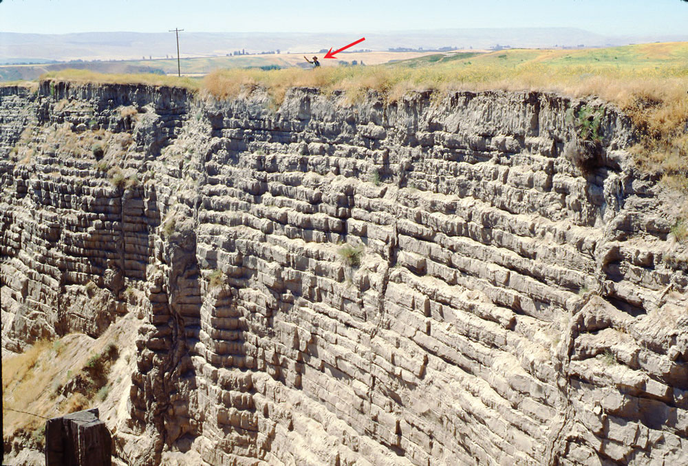
Not all of the Missoula floodwater was able to pass through a narrow gap in south-central Washington, so it backed up and formed an instant lake around 245 m (800 ft) deep in central Washington. This spread sediments up tributary valleys creating well-layered sedimentary deposits up to 30 m (100 ft) thick (fig. 2). This is a good example of how quickly thick layers can form in a flood. It is not difficult to believe the Genesis Flood could lay down thousands of metres of layers over large areas.
Just one flood
For forty years, secular geologists denied the Lake Missoula flood happened, despite hundreds of pieces of evidence. They thought it was too ‘biblical’ in scale. Although it is now accepted, most secular geologists believe forty or more separate floods have occurred.
In truth, the data overwhelmingly indicate there was only one large Lake Missoula flood, but possibly followed by a few smaller floods.5,6 Eight secular geologists from Canada re-evaluated the evidence and also concluded there was only one Lake Missoula flood.7 So all the erosion and deposition was from just one large flood. This provides a tiny example of how the Flood could have deposited some layers and eroded others during the global Flood of Genesis 6–8 (fig. 3).8

Wide erosion followed by narrow erosion
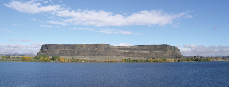
In some areas during the Lake Missoula flood, it appears erosion from wide currents planed the basalt to a nearly flat surface, called a planation surface. Then the flow became channelized, and the resulting erosion dissected the surface, cutting it into smaller areas. One of the erosional channels is the Grand Coulee, which is 80 km (50 miles) long, up to 9 km (6 miles) wide, and 275 m (900 ft) deep. The pattern of eroding the land surface flat over a large area, and then dissecting it into smaller pieces, is similar to what we would expect to take place during the Recessive Stage of the Genesis Flood (fig. 3). This same pattern is readily observed all over the world.9

The formation of tall erosional remnants
The Lake Missoula flood left behind a few tall, erosional remnants, like Steamboat Rock (fig. 4), which is found in the middle of the upper Grand Coulee. It is composed of basalt bedrock and is 275 m (900 ft) high. Thousands of similar remnants are found around the world, such as Devils Tower in northeast Wyoming, USA, (fig. 5) and the spectacular Vingerklip in Namibia’s Etosha Park (fig. 6). If the continents had been eroding for hundreds of thousands to millions of years all of these tall monuments would have been destroyed because erosion is much faster on vertical faces than on horizontal or sloping surfaces.10 The Lake Missoula flood demonstrates how tall erosional remnants form quickly during the runoff of a gigantic flood.

The creation of water gaps
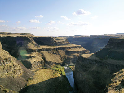
A third feature comparable to the Genesis Flood runoff is water gaps, narrow gorges containing a stream or river that runs through mountains and ridges.11 The most spectacular water gap from the Lake Missoula Flood is the Palouse Canyon. As the floodwaters spilled southward across southeast Washington they flowed over the top of a 150 m (500 ft) ridge, and carved a narrow canyon 150 m (500 ft) deep. The water of the Palouse River once drained west, but after the Lake Missoula flood, it drained south through the narrow Palouse Canyon (fig. 7) and into the Snake River.
This gives us insight into how the Genesis Flood carved the many thousands of water gaps that are seen to cut through mountains and ridges all over the earth. For example, the Shoshone water gap near Cody, Wyoming, (fig. 8) is a 760 m (2,500 ft) deep cut through the Rattlesnake Mountains. Today, the Shoshone River passes through it, but that river could not have carved the gap. The river would have easily been able to pass around the end of the mountains through a low area instead. Water flowing over the top of Rattlesnake Mountains and then draining away during the Genesis Flood runoff easily explains the Shoshone water gap.
The Lake Missoula flood—scale model of the Genesis Flood
The Lake Missoula flood gives us a greater understanding of the erosion and deposition that took place during the Inundatory Stage of the Genesis Flood. It also aids in our understanding of the effects of the Flood water draining from the continents (the Recessive Stage). This would be characterized first by currents flowing in wide sheets, then later by narrower currents flowing in channels. The wide currents would rapidly erode large sheets of sedimentary rock, forming flat plateaus and tall erosional remnants. The later narrower water flows running perpendicular to the mountain barriers would rapidly dissect the surface, forming water gaps.
 |
 |
References and notes
- A.k.a. the Spokane Flood. Return to text.
- Wieland, C., Tackling the big freeze: interview with weather scientist Michael Oard, Creation 19(1):42–43, 1996; creation.com/oard. Return to text.
- Oard, M.J., The Missoula Flood Controversy and the Genesis Flood, Creation Research Society Books, Chino Valley, AZ, 2004. Return to text.
- I.e. a flood thousands of times bigger will not just be a thousand times more destructive, but multiples of that, likely millions of times more so. Return to text.
- Oard, M.J., Only one Lake Missoula flood, J. Creation 14(2):14–17, 2000; creation.com/one-missoula. Return to text.
- Oard, M.J., Further evidence of only one large Lake Missoula flood, J. Creation 26(3):3–4, 2012. Return to text.
- Shaw, J., Munro-Stasiuk, M., Sawyer, B., Beaney, C., Lesemann, J.-E., Musacchio, A., Rains, B., and Young, R.R., The Channeled Scabland: back to Bretz? Geology 27(7):605–608, 1999. Return to text.
- Walker, T., A biblical geologic model; in: Walsh, R.E. (Ed.), Proceedings of the Third International Conference on Creationism, technical symposium sessions, Creation Science Fellowship, Pittsburgh, PA, pp. 581–592, 1994. Return to text.
- Oard, M.J., Flood by Design: Receding Water Shapes the Earth’s Surface, Master Books, Green Forest, AR, 2008. Return to text.
- Twidale, C.R., Geomorphology, Thomas Nelson, Melbourne, Australia, pp. 164–165, 1968. Return to text.
- Oard, M.J., Do rivers erode through mountains?, Creation 29(3):18–23, 2007; creation.com/watergaps. Return to text.

Readers’ comments
Comments are automatically closed 14 days after publication.