

Journal of Creation 27(2):62–70, August 2013
Browse our latest digital issue Subscribe
Surficial continental erosion places the Flood/post-Flood boundary in the late Cenozoic
Major, surficial continental erosion provides substantial physical evidence for the Genesis Flood. Four direct methods of measuring surficial continental erosion are used to determine the vast amount of erosion over select regions of the continents, such as the Colorado Plateau, the Appalachian Mountains, and the Rocky Mountains. Significant erosion of the top of valley-and basin-fill sedimentary rocks in the Rocky Mountains—up to 850 m in Wyoming, 1,520 m in Colorado, and 1,000 m in New Mexico—can be demonstrated. Eroded debris from the continents formed thick continental margin sedimentary rocks. The character of resulting landforms is unique and indicates large-scale processes. More significantly, this erosion occurred in the mid to late Cenozoic, assuming the geological column for sake of discussion, strongly suggesting a Flood/post-Flood boundary in the late Cenozoic, often in the very late Cenozoic.

The Flood/post-Flood boundary is a topic of some interest for Flood models. It controls the extent and timing of Flood and post-Flood events as represented in the rock record. I will assume the general order of the geological column for the sake of discussion in this article, since many creationists believe the geological column, minus the old ages, represents the order of biblical earth history.1 I have come to accept that the geological column represents a general order with lots of exceptions.
Fourteen previously published criteria indicate a late Cenozoic boundary for the Flood’s end.2 A follow-up article has emphasized some of these criteria with nine examples from the sedimentary rocks and geomorphology.3 There are many more criteria that show a late Cenozoic boundary. The late Cenozoic is the location in the geological column that is broken down into Miocene, Pliocene, and Quaternary, the latter consisting predominantly of the Pleistocene. I believe every stratigraphic site needs to be evaluated on its own merits. As a result I have often concluded that the Flood/post-Flood boundary is in the early to mid Pleistocene at various locations. However, in other areas, I have found evidence it could be in the Miocene or Pliocene. We cannot trust the radiometric and biostratigraphic dates of the late Cenozoic as being accurate in a relative sense.
One of the strongest lines of evidence for Flood runoff, and a Flood/post-Flood boundary near the top of the geological column, is the amount and nature of observed erosion on the surface of the continents. The nature of this erosion must be interpreted from field data on a case-by-case basis. However, the amount, which is also determined from individual locales, can be extrapolated across wider areas.
Methods of estimating surficial continental erosion
There are several methods for estimating the amount of erosion in a region. Some of them are indirect, such as chemical and cosmogenic isotopic methods, which rely on radiometric dating. Since these methods are based on uniformitarian assumptions, other more scientific methods will be used.
Minimum erosional values can be determined from the height of tall erosional remnants, called inselbergs (they are also called monadnocks, bornhardts, or tower karst in limestone terrain).4 Examples include Devils Tower in northeast Wyoming, USA, and Ayers Rock in central Australia. There are thousands of these erosional remnants across the earth. Tall erosional remnants with cliffs, like Steamboat Rock (figure 1) in the Upper Grand Coulee of central Washington State, USA, were formed rapidly in the massive Lake Missoula flood at the peak of the Ice Age.5 Thus, it appears that catastrophic floods will create these remnants by eroding all the rock around them. Since erosional remnants are often sedimentary rocks and the rock is well indurated at the top, it is not unreasonable to add another 300 m or more to represent the overburden necessary for compaction and lithification. Because this amount is so uncertain, only the top of the erosional remnant will be used and, therefore, estimates presented here will remain minimum erosional values.

An anticline is a fold, generally convex upward, the core of which contains older rocks.6 When the centre axis of an anticline is eroded, the amount of missing section can be calculated from the dip of the strata on the limbs, assuming that they were the same thickness over the eroded top of the anticline. Figure 2 illustrates the hypothetical uplift of an anticline and subsequent erosion of its top during the Flood. Calculating the missing section at the centre of the anticline is relatively easy with trigonometry. Essentially, it calls for projecting dipping beds on the limb up to the axis, and then subtracting the elevation of the existing rock. If the beds thinned over the axis, the calculation is still a good estimate. And the estimate is probably low, given the likelihood of additional strata overlying the anticline prior to uplift and erosion.
A third method is that of using coal rank at or near the surface. The formation of coal is supposed to be related to temperature, with rank increasing with higher temperature from lignite, to bituminous, to anthracite coal. Since temperature is usually a function of depth of burial, higher-rank coals suggest deeper burial and, thus, greater erosion. Other factors can complicate the calculation, and one must assume a certain geothermal gradient in the past (usually the same as in the present), but coal rank does provide an educated guess. In any case, the presence of bituminous or anthracite coal at or near the surface typically suggests prior burial under several thousand metres of rock.
A fourth and final method of determining erosion on a continental scale is to measure the volume of sediments at the continental margins, which includes the continental shelf and slope, and, along ‘passive continental margins’, the continental rise. If the drainage area for these sediments can be estimated, a rough estimate of total erosion can be made.
Broad-scale erosion of the continents
There have been two main periods of continental erosion with minor periods between. The first is a great scouring of the mostly granite upper crust forming the Great Unconformity as seen in the Grand Canyon. This unconformity is observed in many other locations of western North America and probably the world. After thick sediments were laid on the unconformity, the sediments were sometimes eroded off (e.g. in mountain building), exposing the flat-to-nearly-flat surface as an exhumed planation surface.
The second major period of erosion occurred after practically all the sedimentary rocks were laid on the continent and then an extremely large amount of the total rock volume was subsequently eroded. Landforms suggest that the surficial erosion occurred in one of two manners: first by widespread sheet erosion, and second by channelized erosion afterwards superimposed on the sheet erosion landforms. Examples of sheet erosion in several locations can help us gain an appreciation for the total amount of surficial erosion that has taken place on the continents.
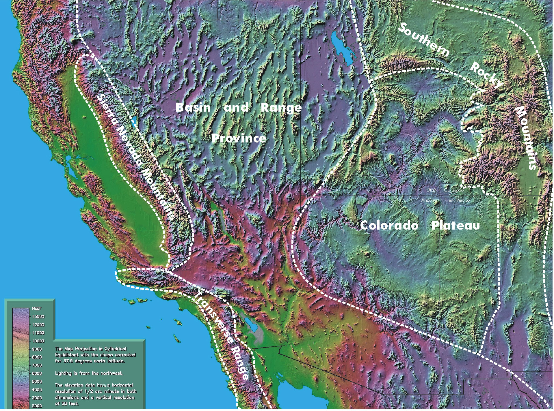
Colorado Plateau
The thick sedimentary rocks of the Colorado Plateau (figure 3) are generally mildly deformed into domes and basins (anticlines and synclines). The domes have been heavily eroded. Using direct measurement of thicknesses and angles, an estimate of this erosion can be made.
The Grand Staircase (figure 4) is part of the western Colorado Plateau, and is shown by the north–south line in figure 3. It represents the eroded north limb of a huge east–west anticline that was once centered near Grand Canyon. The sedimentary rocks that form cliffs in the Grand Staircase are about 3,000 m thick. They are erosional remnants of strata that once extended far south. Since the assumption of constant thickness might be overly generous, we will assume that the missing sedimentary layers thinned by about 40% to the south. Based on this estimate, the minimum amount of erosion creating the Grand Staircase would have been 1,830 m. Furthermore, if the 600-m-thick, widespread Marysvale Volcanic Field, which overlies the Grand Staircase back to the north (figure 5), was present to the south, it would add that thickness, bringing the minimum thickness up to 2,430 m. Therefore, estimates of erosion range from 2,430 m up to 3,600 m over the Grand Canyon area before the canyon formed!

The top layer of the Grand Staircase, the Claron Formation (often wrongly ascribed to the Wasatch Formation) is dated as early Cenozoic. The Marysvale Volcanic Field is dated from the mid Cenozoic to the early late Cenozoic.7 Since all of these rocks had to be emplaced before erosion, the sheet erosion of this rock, from northern Arizona and southern Utah, must have occurred in the late Cenozoic, arguing for a post-Flood boundary in that area during the very late Cenozoic.
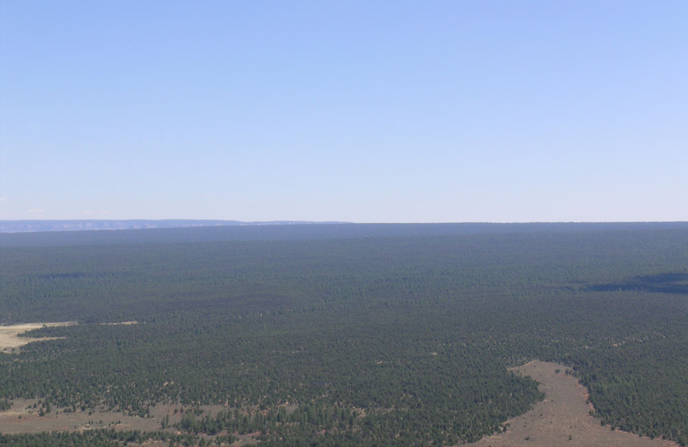
This erosion created a planation surface in the Grand Canyon area (figure 6). Planation surfaces of this scale are not forming today. This erosion-caused planation surface also formed late in the Cenozoic.
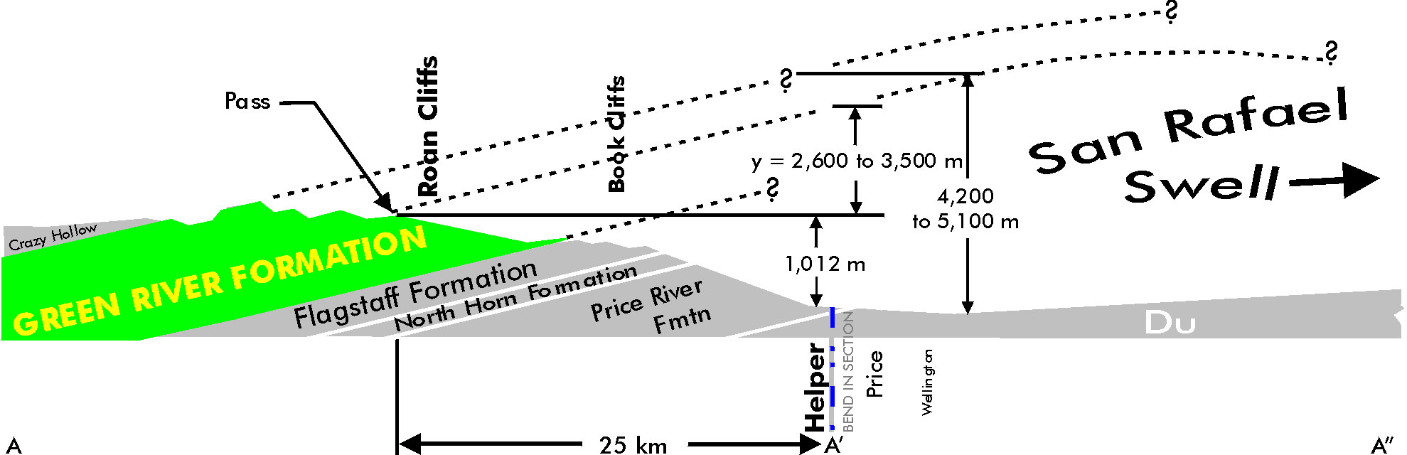
Another location on the Colorado Plateau where erosion can be mechanically calculated is at the San Rafael Swell, in the north-western plateau area, shown by the ellipse in figure 3. It is 120 km by about 65 km.8 The sedimentary rocks of the north limb of the San Rafael Swell, north of Price, Utah, make up the Roan and Book Cliffs and dip about 8° down toward the north-northeast. Oard and Klevberg calculated the amount of missing section above Price, Utah, where the sedimentary rocks start to flatten out.9 Including a conservative dip of 6°, the amount of missing section was calculated as from 3,660–4,575 m. It is likely that the figure should be greater. North of a high pass on Highway 191, erosional remnants of the top formation, the Green River Formation, are about 600 m high, indicating that another 600 m of sedimentary rock once extended over the anticline. So, the total minimum erosion from the San Rafael Swell is 4,200–5,100 m (figure 7)!

Based on geological clues on the Colorado Plateau at the Grand Staircase and the Roan and Book Cliffs, an average of 2,500–5,000 m of erosion occurred over the entire Colorado Plateau!10 Since the Colorado Plateau represents an area of about 337,000 km2, the volume of rock removed by erosion is 842,000–1,700,000 km3. Since these sediments are not found on the continent, they must have been carried completely off the continent, indicating a large-scale flow of water at high velocities, one consistent with the Recessive Stage of the Flood. For the purposes of this paper, that once again puts the post-Flood boundary in the very late Cenozoic on the Colorado Plateau.
Appalachian Mountains
We have all heard that the Appalachian Mountains of the eastern United States appear old and worn down by erosion. Pazzaglia and Gardner quantify this perception in their estimate of total erosion from the mountains by arguing that over 7 km of rock was removed.11 The proposed age of the Appalachians is a conclusion of uniformitarian geology, one that assumes hundreds of millions of years to erode and smooth mountains. Their rounded appearance does give the impression of the Appalachians’ great age. Since the rocks of the Appalachian region are dated as young as Paleozoic, it is assumed the erosion occurred afterwards, in the mid Mesozoic and Cenozoic, as shown by the dates of the strata off the east coast.12 However, since the erosion took off the top of the sedimentary rocks, it must have occurred near the end of the Flood. If so, is their estimate of erosion still valid? Two different methods yield the same result of about 6.4 km!13
The first method is that of measuring the coal rank at or near the surface. Coal is common in sedimentary rocks just west of the Blue Ridge Mountains. It ranges from high-rank anthracite to medium-rank bituminous, with the rank generally increasing to the southeast.14 Friedman and Sanders stated that the anthracite coal of the Catskill Mountains of New York indicate about 6.4 km of erosion there, assuming a normal temperature gradient.15 If they are correct, their argument would also apply to anthracite coal found near the surface in the sedimentary rock west of the Blue Ridge Mountains. A higher temperature gradient would require less overburden and consequently less erosion.14 Areas with bituminous coal would also require less overburden. For these areas, 4.0–6.4 km of erosion is probably a reasonable estimate of the depth of erosion.
The second method is the volume of sedimentary rocks found on the continental margin. East of the Appalachians, especially in the southern ranges, is a piedmont of metamorphic and igneous rocks. Further east, a sedimentary wedge marks the westward terminus of the continental margin sediments. The boundary of this wedge often occurs at the Fall Line. The sedimentary rocks from the Fall Line to the continental rise represent a seaward prograding and thickening wedge of sediments and sedimentary rock.16,17 These sediments and rocks most likely are the eroded remnants of a much higher Appalachian chain, probably resulting from the late Flood vertical tectonics4 as deduced from all over the earth, and described in the Bible as the uplift of the continents and the sinking of the ocean basins.18 Based on the total amount of sedimentary rocks offshore, the total amount of erosion from east of the Appalachian divide is about 6 km.13
Poag and Sevon state: “The primary forcing mechanisms considered have been tectonic and isostatic uplift and subsidence”.19 Tectonic uplift of the eastern United States is believed to have caused the erosion, while the total amount of subsidence off the coast along the continental margin is believed to be 14 km to accommodate the thick sediments!12,18 This statement reminds us of Psalm 104:8a, the mechanism God applied to drain the floodwater: “The mountains rose; the valleys sank down.” Isostatic uplift is a secondary tectonic force caused by the removal of rock. Conversely, the addition of sediments is also a secondary mechanism that will add to the great rifting and downwarping of the ocean margin.
Erosion was rapid
Several areas in the western United States demonstrate that the erosion was rapid and also recent. For instance, Devils Tower would not remain standing for millions of years while all the surrounding plains were eroded.20 This is because vertical rock faces are more easily eroded since they are strongly affected by gravity, causing rock slides and falls.21,22 Furthermore, the extensive vertical cracks of the tower would be prone to destruction by freeze-thaw weathering. Cracks fill with water during storms, and as the water freezes during cold periods, the cracks enlarge. One would expect blocks of rock to frequently break free and fall to the base of the tower each winter. And indeed that is what is observed today:
“While living near the base of the Tower in November 1954, during periods of frost action at night one could hear blocks crash onto the talus. This would happen typically after a snowfall … . On a warm sunny day the snow would melt and the moisture would enter the joints [vertical cracks] in the Tower. After dark, the water would freeze and expand, which over time continues to force blocks from the Tower and build more talus.”23
Devils Tower should have been destroyed quickly in a timeframe of tens of thousands of years, certainly in less than 100,000 years.
Uniformitarian geologists, of course, believe that the whole Grand Canyon area was eroded by water over millions of years during the Great Denudation that formed the Grand Staircase. However, there are subtle but powerful indications that the Great Denudation was not slow but very rapid, as we would expect in the powerful runoff of the Genesis Flood. This evidence is found largely in the type of rock that eroded from the top of the fifth ‘stair’ of the Grand Staircase. The soft Claron Formation (the Pink Cliffs) makes up the top or the fifth stair, but volcanic rock once capped it, as shown by volcanic rock that crops out on the northern portion of the fifth stair (figure 5). C.H. Crickmay noted the perplexing erosional relationships between the 600 m of hard volcanic rock eroded north from the top of the northern Table Cliffs Plateau and the erodible and soft Claron Formation that forms the top of the plateau:
“For example, nothing strikes a visitor more than the preservation of upland surfaces in the High Plateau country of Utah; particularly, the vertical succession of survivals. One of the highest is the Aquarius Plateau, formed on top of about 600 m of resistant lavas. But, protruding from below these volcanics, stands the Table Cliffs Plateau composed of the erodible Wasatch Formation, from which the resistant capping of volcanics has been stripped; nevertheless the unresistant formation has maintained a plateau form while the surround country, over vast areas, has been lowered another 1,200 m or more.”24
If we closely follow what Crickmay is saying, we see that the hard volcanic rock of the Aquarius Plateau eroded first, exposing the soft strata of the Wasatch Formation (now the Claron Formation). Then about 1,200 m of strata below and south of the Claron Formation of the Table Cliffs Plateau was eroded, forming the other stairs of the Grand Staircase. During all this time, the soft Claron Formation capping the Table Cliffs Plateau was hardly touched!
If the erosion took millions of years, the soft Claron Formation would have easily eroded after the lava cap was removed. In addition, erosion at the higher elevations of the Table Cliffs Plateau would be more rapid, since higher elevations generally receive more precipitation. Figure 8 shows the huge contrast in erosion as seen by Crickmay. The only way the top of the Claron Formation can remain uneroded after the volcanic rock is eroded is if the erosion of the lava happened rapidly, and not over many tens of millions of years, as envisioned by uniformitarian geologists, but recently. This implies that the entire Grand Staircase was eroded rapidly, consistent with the Recessive Stage of the Flood.

Another indication of rapid erosion is also found in the Grand Canyon area. Navajo Mountain near the Utah/Arizona border is about 130 km north-east of Grand Canyon. It stands at 3,166 m above sea level. It is a volcanic mass that formed within sedimentary rocks. Now it stands about 1,830 m above the surrounding sedimentary rocks. Therefore, 1,830 m of sedimentary rock must have eroded quickly over the whole region, similar to Devils Tower, or Navajo Mountain would not exist, since mountains erode much faster than a generally horizontal surface.
Other examples of continental erosion
Other areas of North America demonstrate similarly significant erosion. More than a 1.6 km of rock was eroded from southern Arizona during the Cenozoic.25 Several kilometres of strata disappeared from the Rocky Mountains, foothills, and western Plains of southern Canada in the late Cenozoic.26,27
North America is not unique in this regard. Large-scale erosion scoured other continents, especially in mountainous areas.28,29 Although more estimates of continental erosion can be found in the geological literature, a few will suffice to show that what happened in North America was typical of late Flood erosion.

Figure 9. Uplifted, eroded Wealden Dome of southeast England. Total erosion in the center of the dome is about 1,500 m.
Image: Wikipedia.
Geological features in Australia show that this continent was also heavily eroded.30 For example, 6 km of rock was probably removed from the Flinders Range in South Australia.31,32 In Europe, about 3 km was taken off the Welsh Mountains of the United Kingdom.33 About 1–1.5 km of sedimentary rock was stripped from south-east England (figure 9).34,35
Partridge believes more than 1–3 km of rock was eroded from Southern Africa since the Cretaceous.36 More impressive is the 4–7 km of erosion that occurred in the Cenozoic along the coast of the 260-km-long McMurdo sector of the Transantarctic Mountains.37
Since most mountain uplift occurred during the Cenozoic,38 all this erosion also likely occurred during the Cenozoic, generally in the mid to late Cenozoic.
Rocky Mountain basin and valley erosion
On a smaller scale, we can see other examples of significant erosion in valleys and basins of the Rocky Mountains. This erosion occurred mainly after the sheet erosion phase of the Flood’s retreat and within the channelized erosion. Deep valleys were eroded to depths of over 1,000 m in the Absaroka Volcanics, after the planation of the top of these volcanic debris flows—all occurring in the mid and late Cenozoic.3 The same methods provide good estimates of the minimum amount of erosion in valleys and basins that have thick sedimentary rocks. The following examples are from valleys and basins of the Rocky Mountains, but other basins and valleys around the world undoubtedly would show a similar picture.
The minimum amount of erosion of the top of the basin-or-valley-fill sedimentary rocks in the Rocky Mountains has been determined by geologists based on the first two methods above.39 Average estimates in Wyoming range up to 850 m (table 1). Similar estimates in Colorado reach 1,520 m, and up to 1,000 m in New Mexico. Other estimates of erosion from the High Plains of the United States, where the strata are generally flat, include: (1) around 180 m in north-west Texas, (2) 180 m in south-east Colorado, (3) 120 m in north-west Kansas, (4) around 400 m in western Nebraska, (5) 190 m in south-west South Dakota, and (6) less than 100 m in northeast Montana. These are likely gross underestimates because of the lack of erosional remnants and eroded anticlines on the High Plains. As in many other locations, the bulk of this erosion occurred in the late Cenozoic.

Oard previously estimated the amount of basin-fill erosion of the eastern Bighorn Basin as 744 m based on the heights of Tatman Mountain and the town of Greybull.3 The western Bighorn Basin is significantly higher (about 1,550 m) than the eastern Bighorn Basin, which explains why the average for the Bighorn Basin in table 1 is lower than Oard’s estimate for the eastern Bighorn Basin. With an average of 470 m of erosion, the volume eroded from the Bighorn Basin is about 10,000 km3.
Sheet deposition along the edge of the continents
Many continental margins are marked by thick sedimentary wedges extending up and down their coast. Prominent examples include the Atlantic Coastal Plain and Gulf Coastal Plain in the United States. These basins and sediments are relatively young, and their sediment was derived from continental erosion. These sedimentary wedges can reach thicknesses of a few 10s of kms, and the total volume of these features is another indicator of the extensive late erosion from the continental interiors. Because most of these deposits are considered to be Cenozoic, they form one of the original 14 criteria used to determine the location of the Flood/post-Flood boundary, which in this case would be in the very late Cenozoic.2
Unique erosional features left behind
As mentioned above, landform features provide one of the best evidences for continental erosion. These features include everything from planation surfaces to wind and water gaps,4 including large-scale features such as Grand Canyon. One of the underexploited areas for creationist research has been geomorphology. That is because features that have remained frustrating mysteries to uniformitarian geologists for more than a century are readily explained by Flood processes. It is the consistently late ages of these features (many in the late Cenozoic)2 that lead to the confident conclusion that the rock record representing the Flood includes rocks up to and through the late Cenozoic, depending on the location. Any diluvialist wishing to place the boundary lower in the rock record, for example at the K/T boundary, must be prepared to explain all of these late geomorphic features in terms of post-Flood catastrophism, a task that seems both difficult and unnecessary.
Summary and implications
One of the easiest methods to determine the post-Flood boundary is to estimate the age and amount of erosion in a given area. Based on direct scientific methods, the amount of continental erosion is typically quite large and quite late. Calculations range up to 5 km over the Colorado Plateau and 6 km over the Appalachians. Furthermore, the magnitude is put in better perspective when we remember that the average sedimentary rock cover on the continents is only 1.8 km (see below). Minimum erosion can be estimated on smaller scales, such as the basins and valleys of the Rocky Mountains, in which around 1,000 m of missing section can be calculated.
Wherever the erosion took place on the continent, the sedimentary particles were often carried long distances, even to the margins. With the vertical tectonics of continental uplift and ocean basin subsidence, large basins were created there to contain these sedimentary wedges, such as the Gulf of Mexico. Unique landform features were created by the Recessional Stage of the Flood, and are readily explained by those large-scale events, even though they remain unsolved mysteries for uniformitarian geologists, and are also difficult to account for using the concept of post-Flood catastrophism.
The geomorphology of the earth’s surface shows a transition in the surface features from the products of widespread sheet flow erosion, such as planation surfaces, to the channelized incision of features like wind and water gaps: “The transition from widespread planation of the landscapes during the Tertiary to valley development and incision during the Quaternary is well documented in Europe.”40 This is exactly what is expected during the Recessive Stage of the Flood. This transition from sheet flow erosion to channelized flow erosion would be dependent on topography and location, but would generally occur sooner at elevated regions that were first exposed as the floodwaters receded.
It cannot be overemphasized that the timing of all these regional scale features is late in the rock record. Surficial planation surfaces (not exhumed) began to be formed during the Cenozoic, representing the events of the early Recessional Stage of the Flood called the Abative Phase.41 Valleys and canyons, typical of the Dispersive Phase of the Recessional Stage, were carved afterwards.4 Uniformitarian geologists attempt to explain the creation of these features in terms of their repeating ice ages, up to 50 or more,42 assuming the astronomical theory of the ice ages. But this idea assumes many ice ages and so valleys and at least the upper terraces need to be related to non-existent ice ages in the uniformitarian scheme.43 (The explanation of river terraces needs to be examined within biblical earth history and is beyond the scope of this article.)
Practically all the surficial erosion of large areas of continents, as well as basins and valleys of the Rocky Mountains, occurred in the mid to late Cenozoic. This erosion, as inferred from the unique landforms on earth’s surface, seems impossible to explain by post-Flood catastrophism but provides strong evidence instead for their formation during the Recessional Stage of the Flood.41
Advocates of a K/T Flood/post-Flood boundary must postulate huge post-Flood catastrophes during the Cenozoic. They have yet to postulate any mechanisms to explain this large-scale catastrophic erosion and that these mechanisms would be superior to that proposed here. The problem grows by orders of magnitude for those advocates of a Flood/ post-Flood boundary in the late Paleozoic or even in the Precambrian, the latter called the Recolonization Model.44,45 At present, the best explanation remains the runoff of the Genesis Flood, as proposed long ago by Holt, when he coined the term Erodozoic for the time in which the sediments and sedimentary rocks were eroded off the top of the continents.46
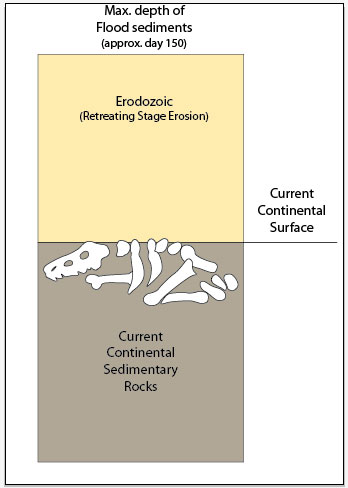
Figure 10 summarizes the argument for late Cenozoic erosion by the retreating Flood. There is approximately 1,800 m average depth of sedimentary rocks on the continents.47 Based on the estimates of erosion, a conservative average erosion of the continents would be around 500 m. So, at the peak of the Flood, the total thickness would be around 2,300 m, deposited early in the Flood during the Inundatory Stage. This means that the uniformitarian view that the rock record is a representative snapshot of events throughout earth history must be set aside in favour of a view that suggests that the uppermost 20–25% of the rock record deposited during the Flood was removed by its retreat, and that the remaining rocks were deposited in the early to middle Flood. This is another instance in which uniformitarian thinking is subliminally introduced into diluvial research. Since the last half of the Flood was primarily erosional on the continents, practically all the fossils were buried on the continents during the Inundatory Stage, just as Roy Holt deduced: “It is incredible that these evidences suggest that the majority of activity of the Flood occurred within the first 150 days.”48
References
References and notes
- Reed, J.K. and Oard, M.J. (Eds.), The Geological Column: Perspectives within Diluvial Geology, Creation Research Society Books, Chino Valley, AZ, 2006. Return to text.
- Oard, M.J., Defining the Flood/post-Flood boundary in sedimentary rocks, J. Creation 21(1):98–110, 2007. Return to text.
- Oard, M.J., Geology indicates the terrestrial Flood/post-Flood boundary is mostly in the Late Cenozoic, J. Creation 27(1):119–127, 2013. Return to text.
- Oard, M.J., Flood by Design: Receding Water Shapes the Earth’s Surface, Master Books, Green Forest, AR. Return to text.
- Oard, M.J., The Missoula Flood Controversy and the Genesis Flood, Creation Research Society Monograph No. 13, Chino Valley, AZ, 2004. Return to text.
- Neuendorf, K.K.E., Mehl, Jr, J.P. and Jackson, J.A., Glossary of Geology, 5th Edition, American Geological Institute, Alexandria, VA, p. 28, 2005. Return to text.
- Rowley, P.D., Mehnert, H.H., Naeser, C.W., Snee, L.W., Cunningham, C.G., Stevens, T.A., Anderson, J.J., Sable, E.G. and Anderson, R.E., Isotopic ages and stratigraphy of Cenozoic rocks of the Maryvale Volcanic Field and adjacent areas, west-central Utah, U.S. Geological Survey Bulletin 2071, U.S. Government Printing Office, Washington, D.C., 1994. Return to text.
- Huuse, M., Shoulders, S.J., Netoff, D.I. and Cartwright, J., Giant sandstone pipes record basin-scale liquefaction of buried dune sands in the Middle Jurassic of SE Utah, Terra Nova 17, p. 81, 2005. Return to text.
- Oard, M.J. and Klevberg, P., The Green River Formation very likely did not form in a postdiluvial lake, Answers Research J. 1:99–108, 2008. Return to text.
- Schmidt, K.-H., The significance of scarp retreat for Cenozoic landform evolution on the Colorado Plateau, U.S.A., Earth Surface Processes and Landforms 14:93–105, 1989. Return to text.
- Pazzaglia, F.J. and Gardner, T.W., Late Cenozoic landscape evolution of the US Atlantic passive margin: insights into a North American Great Escarpment; in: Summerfield, M.A. (Ed.), Geomorphology and Global Tectonics, John Wiley & Sons, New York, p. 287, 2000. Return to text.
- Poag, C.W., U.S. middle Atlantic continental rise: provenance, dispersal, and deposition of Jurassic to Quaternary sediments; in: Poag, C.W. and P.C. de Graciansky (Eds.), Geological Evolution of Atlantic Continental Rises, Van Nostrand Reinhold, New York, pp. 100–156, 1992. Return to text.
- Oard, M.J., Origin of Appalachian Geomorphology Part I: erosion by retreating Floodwater, Creation Research Society Quarterly 48(1):33–48, 2011. Return to text.
- Hower, J.C. and Rimmer, S.M., Coal rank trends in the Central Appalachian coalfield: Virginia, West Virginia, and Kentucky, Organic Geochemistry 17(2):161–173, 1991. Return to text.
- Friedman, G.M. and Sanders, J.E., Time-temperature-burial significance of Devonian anthracite implies former great (~6.5 km) depth of burial of Catskill Mountains, New York, Geology 10:93–96, 1982. Return to text.
- Klitgord, K.D., Hutchinson, D.R. and Schouten, H., U.S. Atlantic continental margin; structural and tectonic framework; in: Sheridan, R.E. and Grow J.A. (Eds.), The Geology of North America, Volume I–2: The Atlantic Continental Margin: U.S., Geological Society of America, Boulder, CO, pp. 19–55, 1988. Return to text.
- Poag, C.W. and Valentine, P.C., Mesozoic and Cenozoic stratigraphy of the United States Atlantic continental shelf and slope; in: Sheridan, R.E. and Grow J.A. (Eds.), The Geology of North America, Volume I–2: The Atlantic Continental Margin: U.S., Geological Society of America, Boulder, CO, pp. 67–85, 1988. Return to text.
- Poag, C.W. and Sevon. W.D., A record of Appalachian denudation in post-rift Mesozoic and Cenozoic sedimentary deposits of the U.S. middle Atlantic continental margin, Geomorphology 2:119–157, 1999. Return to text.
- Poag and Seven, ref. 18, p. 119. Return to text.
- Oard, M.J., Devils Tower can be explained by floodwater runoff, J. Creation 23(2):124–127, 2009. Return to text.
- Twidale, C.R., Geomorphology, Thomas Nelson, Melbourne, Australia, pp. 164–165, 1968. Return to text.
- Pazzaglia, F.J., Landscape evolution models; in: Gillespie, A.R., Porter, S.C. and Atwater B.F. (Eds.), The Quaternary Period in the United States, Elsevier, New York, p. 249, 2004. Return to text.
- Robinson, C.S. and Davis, R.E., Geology of Devils Tower, Wyoming, Devils Tower Natural History Association, p. 36, 1995. Return to text.
- Crickmay, C.H., The Work of the River: A Critical Study of the Central Aspects of Geomorphology, American Elsevier Publishing Co., New York, p. 238, 1974. Return to text.
- Oard, M.J. and Klevberg, P., Deposits remaining from the Genesis Flood: Rim Gravels in Arizona, Creation Research Society Quarterly 42(1):1–17, 2005. Return to text.
- Bustin, R.M., Organic maturity in the western Canada sedimentary basin, International J. Coal Geology 19:319–358, 1991. Return to text.
- Osborn, G., Stockmal, G. and Haspel, R., Emergence of the Canadian Rockies and adjacent plains: a comparison of physiography between end-of-Laramide time and the present day, Geomorphology 75:450–477, 2006. Return to text.
- King, L.C., Wandering Continents and Spreading Sea Floors on an Expanding Earth, John Wiley and Sons, New York, pp. 197–214, 1983. Return to text.
- Pazzaglia, F.J. and Gardner, T.W., Late Cenozoic landscape evolution of the US Atlantic passive margin: insights into a North American Great Escarpment; in: Summerfield, M.A. (Ed.), Geomorphology and Global Tectonics, John Wiley & Sons, New York, pp. 283–302, 2000. Return to text.
- Galloway, R.W., Introduction; in: Davies, J.L. and Williams, M.A.J. (Eds.), Landform Evolution in Australasia, Australian National University Press, Canberra, Australia, pp. 1–4, 1978. Return to text.
- Chorley, R.J., Schumm, S.A. and Sugden, D.E., Geomorphology, Methuen, London, UK, p. 165, 1984. Return to text.
- Twidale, C.R. and Campbell, E.M., Australian Landforms: Understanding a Low, Flat, Arid and Old Landscape, Rosenberg Publishing, Dural Delivery Centre, New South Wales, Australia, p. 195, 2005. Return to text.
- Small, R.J., The Study of Landforms: A Textbook of Geomorphology, second edition, Cambridge University Press, London, U.K., p. 266, 1978. Return to text.
- Japsen, P., Regional Neogene exhumation of Britain and the western North Sea, J. Geological Society, London 154:239–247, 1997. Return to text.
- Jones, D.K.C., On the uplift and denudation of the Weald; in: Smith, B.J., Whalley, W.B. and Warke, P.A. (Eds.), Uplift, Erosion and Stability: Perspectives on Long-Term Landscape Development, Geological Society of London Special Publication No. 162, The Geological Society, London, UK, p. 32, 1999. Return to text.
- Partridge, T.C., Of diamonds, dinosaurs and diastrophism: 150 million years of landscape evolution in Southern Africa, African J. Geology 101(13):167–184, 1998. Return to text.
- Sugden, D. and Denton, G., Cenozoic landscape evolution of the Convoy Range of Mackay Glacier area, Transantarctic Mountains: onshore to offshore synthesis, GSA Bulletin 116(7/8):840–857, 2004. Return to text.
- Ollier, C. and Pain, C., The Origin of Mountains, Routledge, New York, 2000. Return to text.
- McMillan, M.E., Heller, P.L. and Wing, S.L., History and causes of post-Laramide relief in the Rocky Mountain orogenic plateau, GSA Bulletin 118(3/4):393–405, 2006. Return to text.
- Maddy, D., Uplift-driven valley incision and river terrace formation in southern England, J. Quaternary Science 12(6):539, 1997. Return to text.
- Walker, T., A biblical geologic model; in: Walsh, R.E. (Ed.), Proceedings of the Third International Conference on Creationism, technical symposium sessions, Creation Science Fellowship, Pittsburgh, PA, pp. 581–592, 1994. Return to text.
- Walker, M. and Lowe, J., Quaternary science 2007: a 50-year retrospective, J. Geological Society, London 164:1073–1092, 2207. Return to text.
- Oard, M.J., Frozen In Time: The Woolly Mammoth, the Ice Age, and the Biblical Key to Their Secrets, Master Books, Green Forest, AR, 2004. Return to text.
- Tyler, D.J., Recolonization and the Mabbul; in: Reed, J.K. and Oard, M.J. (Eds.), The Geological Column: Perspectives within Diluvial Geology, Creation Research Society Books, Chino Valley, AZ, pp. 73–88, 2006. Return to text.
- Reed, J.K., Kulikovsky, A.S. and Oard, M.J., Can recolonization explain the rock record? Creation Research Society Quarterly 46(1):27–39, 2009. Return to text.
- Holt, R.D., Evidence for a late Cainozoic Flood/post-Flood boundary, J. Creation 10(2):128–167, 1996. Return to text.
- Reed, J.K. and Oard, M.J., Three early arguments for deep time—part 3: the ‘geognostic pile’, J. Creation 26(2):100–109, 2012. Return to text.
- Holt, ref. 46, p. 162. Return to text.


Readers’ comments
Comments are automatically closed 14 days after publication.