

The Cal Orcko (‘Lime Hill’) dinosaur trackways
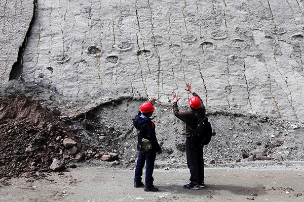
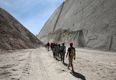
In 1994, Bolivian workers quarrying high-grade limestone for cement reached a layer with too much quartz, a hard mineral, so they left it alone.1 As quarrying continued, more and more of the unwanted layer was exposed, forming a huge cliff and revealing hundreds of dinosaur trackways. The tracks are of at least eight different kinds of dinosaurs, including a pair of titanosaurs and a herd of 16 ankylosaurs. The layer also contains the longest dinosaur trackway in the world, over 500 m (1,640 ft), by a small theropod,1 possibly a juvenile Tyrannosaurus rex.2
These rocks are part of the El Molino Formation which extends over much of Bolivia. The Vilquechico Formation of Peru and the Yacoraite Formation of Argentina contain similar dinosaur trackways, and all three are suspected to be merely different parts of the one continent-wide formation.3
The El Molino Formation has cycles of layers (see diagram 1), each cycle consisting of a similar depositional sequence of various sandstone, limestone, and claystone sediments. Most layers contain assorted types of fossils, mainly marine. Within the particular 22-metre thickness that includes the Cal Orcko cliff, 11 depositional cycles have been described, seven containing a layer with dinosaur tracks.4 The cliff face consists mainly of the single high-quartz layer (tracklevel ‘5’ in diagram 1), though there are patches of cliff where overlying or underlying layers are revealed.

These tracks would have been made toward the end of the first half5 of the Flood, before all the animals had perished.6 While globally the sea level was remorselessly rising, in each locality the sea would continuously surge and recede (see diagram 2) due to tectonic movements, tsunamis, lunar tides, and large-scale currents. This would repeatedly cover and re-expose areas, before eventually all the land was deeply underwater. New layers would continually be being deposited from the sediment-laden waters, potentially burying and preserving the freshly-laid tracks of surviving animals desperately seeking safety. In their few hours of exposure the track-bearing sediments would partially harden, helping them resist erosion by the next rush of water. Each depositional cycle in the rock likely represents a surge and recession of water. In this way, the aforementioned 22 m thickness was probably laid down in a few days or less. Later in the Flood, tectonic forces pushed the earth’s crust around, forming gigantic folds in the still-soft sedimentary layers. The near-vertical (72°) cliff at Cal Orcko is a portion of one such fold.
A ‘Cretaceous Park’ tourist centre was established at Cal Orcko in 2006, but the cliff and its spectacular trackways are rapidly eroding, and could be “completely damaged” by 2020.2 Proposed preservation measures include rock bolts, anchors and wire nets, and impregnation of the rock with chemicals to harden and waterproof it.1 This speaks strongly against the idea that these rocks and the tracks they contain could have already endured 65 million years of natural processes, because not just these rocks but the whole continent would have eroded away well before that.7

The daily routine of most animals typically involves lots of meandering about, foraging for food, etc., but the dinosaur trackways at Cal Orcko, like virtually all other known dinosaur trackways around the world, are relentlessly straight, indicative of frightened animals fleeing danger. Significantly, despite the big vertical gaps between them, the various track-bearing layers of the El Molino Formation contain the exact same fleeing-type tracks of the exact same kinds of dinosaurs. Having the same types of dinosaurs exhibiting the same unusual behaviour at the same point on the earth’s surface (separated only by the layers laid down in the meantime) is more consistent with the oscillating Floodwaters scenario than with the idea that those layers are separated by millions of years.
The Cal Orcko cliff and its dinosaur trackways are a sobering testament to the cataclysmic Flood recorded in the Bible, in which every living nostril-breathing creature that moved on land perished (Genesis 7:21).
References and notes
- Thüring, B. and 3 others, Cal Orcko, the world’s largest dinosaur tracksite—Aspects of assessment, protection and conservation, in: 1st Meeting of the EAVP [European Association of Vertebrate Palaeontologists]: Abstracts with program, Natural History Museum Basel, 15–19 July 2003; eavp.org/abstracts/1stWEAVPabstracts.pdf.. Return to text.
- Sucre’s Dinosaur Park and Footprints (Parque Cretácico) Sucre Life; sucrelife.com/sucres-dinosaur-park. Return to text.
- Meyer, C.A., Hippler, D., and Lockley, M.G., The Late Cretaceous vertebrate ichnofacies of Bolivia—facts and implications, in: Publication Especial 7: VII International Symposium on Mesozoic Terrestrial Ecosystems: 133–138, Asociación Paleontólogica Argentina, Buenos Aires, 30 June 2001. Return to text.
- Tracklevels 1–7 in Figure 3, Meyer, ref. 3. Return to text.
- I.e. the early Zenithic Phase in Walker’s Biblical Geological Model; biblicalgeology.net. Return to text.
- See book by Oard, M., Dinosaur Challenges and Mysteries: How the Genesis Flood makes sense of dinosaur evidence—including tracks, nests, eggs, and scavenged bones, Creation Book Publishers, 2011; creation.com/s/10-2-582. Also creation.com/dino-stampede#beds. Return to text.
- See e.g. Walker, T., Vanishing coastlines, Creation 29(2):19–21, 2007; creation.com/vanishing-coastlines. Return to text.
- Oard, ref. 6, p. 120. Return to text.


Readers’ comments
Comments are automatically closed 14 days after publication.