

Testimony to the Flood
A remarkable planation surface in Canada

During the Recessive Stage of the Flood1 the mountains rose up and the valleys sank. This caused huge quantities of rock and dirt to wash into the new oceans of the world.2 The magnitude of this, such as the estimated thickness of sediment eroded, is largely undisputed among geologists of all persuasions. For example, it is accepted that erosion has removed about 6,000 m (20,000 ft) of rock from the Appalachian Mountains of the eastern USA.3 They are therefore said to ‘look old’—because the conventional (uniformitarian) notion is that it happened gradually, over millions of years, despite overwhelming evidence to the contrary.
Planation surfaces
One of the more obvious problems for this long-age view is explaining how planation surfaces formed.4 These are large, level land surfaces that have been ‘planed’ flat by running water. Planation surfaces are commonly covered by a thick layer of rounded rocks. It is common knowledge that only running water rounds rocks.
These surfaces, often of vast extent, are found globally and at all altitudes, including on the tops of some mountains. They are especially well developed in Africa and Australia.5 In fact, 60% of Africa is believed to be one huge planation surface that has faulted or folded to different altitudes.6,7 Photographs of the Serengeti Plain in East Africa display its very flat planation surface (figure 1). The rocks beneath the Serengeti are highly deformed, but water has eroded the rough terrain into a flat surface.


Nothing like it happening now
Planation surfaces are not forming today, except on a very local scale when a river floods; instead they are being destroyed by present-day erosion. Amazingly, some of these planation surfaces are considered to be more than 100 million years old. The notion that they have remained flat for all this alleged time, despite the everyday action of erosion, stretches credulity.
The Cypress Hills planation surface
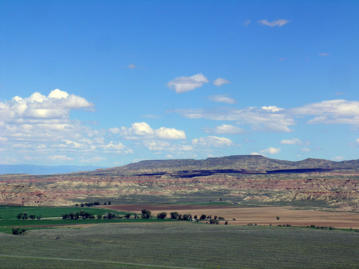
One most remarkable planation surface is the Cypress Hills of southeastern Alberta and southwestern Saskatchewan, Canada. This high plateau with an area of about 4,000 km2 (1,560 sq. miles) is remarkably flat, and lies about 300 m (1,000 ft) above another planation surface surrounding it (figures 2 to 4). The Cypress Hills surface is 750 m (2,500 ft) above rivers flanking it to the north and south. It is capped by a thick veneer, averaging 23 m (75 ft), of well-rounded, water-transported quartzite gravel, cobbles, and boulders (figure 5). The closest source for these rocks is acknowledged to be about 650 km (400 miles) away, in central Idaho, on the other side of the continental divide!8


The work of the Flood
The geomorphology (i.e. the shape) of the Cypress Hills provides some important deductions about the Genesis Flood. This planation surface represents the highest of several quartzite-capped planation surfaces on the High Plains of Canada, eastern Montana, and eastern Wyoming, at different altitudes with respect to the Rocky Mountains to the west (figure 6).
Dr William Alden (1871–1959) was a distinguished US geologist widely acknowledged as an expert on the geology of the once-glaciated areas of North America. He believed that the Cypress Hills planation surface was once connected with several other quartzite-capped remnants (i.e., leftovers from erosion) and planation surfaces over a wide area east of the continental divide, such as the flat-topped Tatman Mountain in the Bighorn Basin of north-central Wyoming (figure 7).9
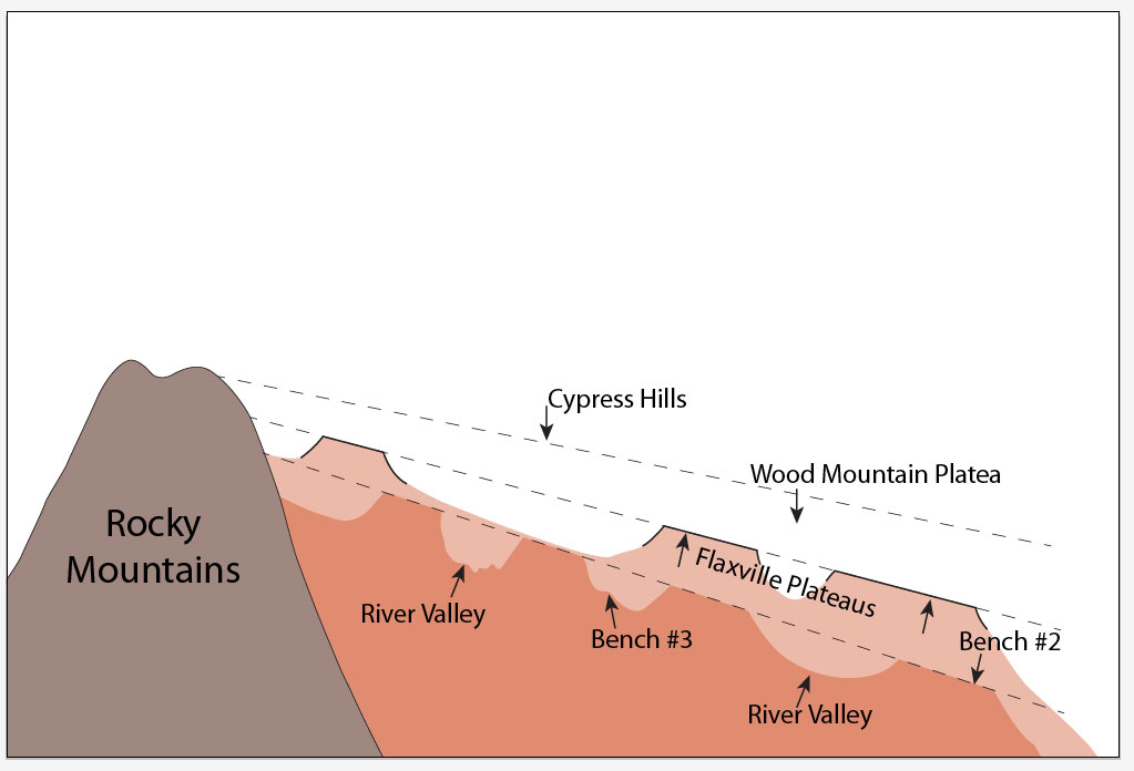
In short, the geomorphology of the Cypress Hills and Tatman Mountain indicates that a single vast planation surface was present on the High Plains, and subsequently eroded. That surface would have stretched at least 1,200 km (750 miles) north-south and 500 km (310 miles) east-west. Billions of rounded quartzite rocks cap the surface and are a testament to the powerful forces that produced these features. Geologists in general agree that these quartzite rocks originated from the uplifted western Rocky Mountains of central and northern Idaho and far western Montana, and spread across many hundreds of kilometres out onto the High Plains. The powerful Flood current must have been at least 1,200 km (750 miles) wide, before the present continental divide formed. Erosion by water currents this wide indicates it was formed during the Abative (or Sheet Flow) Phase of the Recessive Stage of the Flood.1
The sedimentary rocks below the flat top of Tatman Mountain contain low grade coal.10 Conventional geologists agree that it takes a substantial burden of overlying rock for coal to form—thus this coal must have been overlain by hundreds of metres of sediments and sedimentary rock, which was subsequently eroded away.
Further erosion of the original Cypress Hills planation surface resulted in lower planation surfaces capped by quartzite cobbles and boulders. The erosion left the Cypress Hills and Tatman Mountain as erosional remnants of a once vast planation surface. The channelled floodwaters of the Dispersive Phase of the Flood cut river valleys 750 m (2,500 ft) down around the remnant Cypress Hills planation surface.11
If we make the reasonable assumption that the thickness of the sedimentary rock once lying above the Cypress Hills planation surface was about 1,000 m (3,300 ft), the total amount of erosion for the High Plains adds up to around 1,750 m (5,800 ft)!
Battered boulders
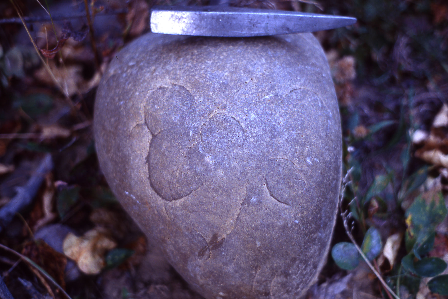
The transportation of the quartzite cobbles and boulders points to a titanic Flood runoff current.12 Quartzite, a metamorphosed sandstone, is one of the hardest rocks in the world, and yet these quartzite cobbles and boulders have numerous percussion marks on their surface (figure 8). These are formed when rocks smash into one another underwater. Percussion marks are not forming on quartzite cobbles and boulders today. This would require a speed of more than 110 km/h (70 mph),13 which is about two to three times the speed of the fastest flash floods on Earth that crash down a steep mountain valley.
Only the powerful runoff of Noah’s Flood would provide the force needed to slam these boulders together and hammer the percussion marks. As in so many other parts of the world, the evidence for the global deluge is overwhelming.
References and notes
- Stages from: Walker, T., A biblical geologic model; in: Proceedings of the Third International Conference on Creationism, technical symposium sessions, Pittsburgh, PA, pp. 581–592, 1994. For a diagram, Biblical Geologic Model. Return to text.
- Oard, M.J., Massive erosion of continents demonstrates Flood runoff, Creation 35(3):44–47, 2013; creation.com/continental-erosion. Return to text.
- Oard, M.J., Origin of Appalachian Geomorphology Part I: erosion by retreating Floodwater, Creation Research Society Quarterly 48(1):33–48, 2011. Return to text.
- Oard, M., It’s plain to see: Flat land surfaces are strong evidence for the Genesis Flood, Creation 28(2):34–37, 2006; creation.com/plain. Return to text.
- King, L.C., The Morphology of the Earth—A Study and Synthesis of World Scenery, Hafner Publishing Company, New York, 1967. Return to text.
- Burke, K., and Gunnell, Y., The African Erosion Surface: A Continental-Scale Synthesis of Geomorphology, Tectonics, and Environmental Change over the Past 180 Million Years, Geological Society of America Memoir 201, Boulder, CO, pp. 1–66, 2008. Return to text.
- Oard, M.J., The remarkable African planation surface. J. Creation 25(1):111–122, 2011; creation.com/african-planation. Return to text.
- Leckie, D.A., and Cheel, R.J., The Cypress Hills Formation (upper Eocene to Miocene): a semi-arid braidplain deposit resulting from intrusive uplift, Canadian Journal of Earth Sciences 26:1918–1931, 1989. Return to text.
- Alden, W.C., Physiography and glacial geology of eastern Montana and adjacent areas, U. S. Geological Survey Professional Paper 174, Washington, D.C., 1932. Return to text.
- Mackin, J.H., Erosional history of the Big Horn Basin, Wyoming, GSA Bulletin 48(6):813–894, 1937. Return to text.
- All this activity occurred in ‘Cenozoic time’ within the uniformitarian geological column, suggesting the Flood/post-Flood boundary is in the Late Cenozoic. Return to text.
- Oard, M.J., Long distance boulder deposits reveal Noah’s Flood, Creation 38(3):24–27, 2016. Return to text.
- Klevberg, P., and Oard, M.J., Paleohydrology of the Cypress Hills Formation and Flaxville gravel; in: Proceedings of the Fourth International Conference on Creationism, Technical Symposium Sessions, Pittsburgh, PA, pp. 361–378, 1998. Return to text.


Readers’ comments
Comments are automatically closed 14 days after publication.