

Journal of Creation 36(3):11–12, December 2022
Browse our latest digital issue Subscribe
The Parallel Roads of Glen Roy
In the Highlands of Scotland there is a valley in the Lochaber area called Glen Roy—Scottish Gaelic: Gleann Ruaidh1—with some intriguing natural features (figure 1). Several horizontal ‘roads’ have seemingly been cut into the metamorphic rock of the hillsides surrounding the valley at different levels. Properly understood, these features are well explained by considering the single Ice Age that followed the global Flood, within the biblical framework of Earth history.

It is not uncommon for fascinating natural phenomena to be associated with a legendary story, folklore, or a fairytale. This is the case with the Giant’s Causeway (there is a clue in the name), which is found on Northern Ireland’s north coast. A related columnar basalt outcrop is seen on Scotland’s Isle of Staffa, famous for Fingal’s cave. In local myth, the constructor of the causeway that originally ran all the way between the two sites was Fionn mac Cumhaill (from which Fingal is derived2), so his feet could stay dry! This same Fingal was also said to have been responsible for constructing the Parallel Roads of Glen Roy.
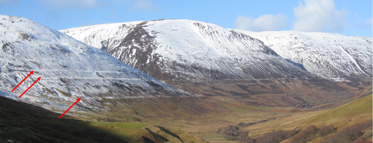
Relief
Clearly visible throughout the Glen Roy Valley are three parallel embankments at different elevations (figure 2). They are approximately 10 m wide, extend for tens of kilometres, and are commonly referred to as ‘parallel roads’.3 These level ‘roads’ are reminiscent of contour lines (also called iso-lines), which connect points of the same altitude on a map. Such features are not restricted to this area, but also exist elsewhere in the world. However, they are very obvious in Glen Roy.
Deep time story

In the 19th century, the Parallel Roads were thought to mark previous shorelines of the sea, with the water being at much higher levels. This thinking was promoted by Charles Darwin (figure 3).4 Darwin eventually conceded that his idea was incorrect. Louis Agassiz proposed that these Parallel Roads were indeed shorelines; lake shorelines. He ascribed the Parallel Roads to sequential ice-dammed lakes during the last glaciation.5 According to this idea, the encroaching glacier blocked the valley, supposedly starting around 12,900 years ago. More and more ice choked the valley, thus forcing the water to rise to higher levels, until it reached a natural drainage point somewhere further up the valley. Accordingly, these ice dams caused the Parallel Roads to form at elevations of 260, 325, and 350 m respectively, before melting about 11,500 years ago and so draining the reservoirs they were holding back.
Problems of an advancing ice dam
Within this explanation, the glacier advanced over a period of up to 1,400 years,6 although the timescales differ somewhat depending on who is doing the telling.7 According to a 2010 paper from the Journal of Quaternary Science, the first lake formed during stage 1 (supposedly lasting 192 years), where the Spean Glacier ice plugged the normal outlet of Glen Spean to the southwest, forcing the water instead to flow out of Glen Spean northeastwardly at 260 m altitude. The second, higher, lake grew during stage 2 (supposedly lasting 112 years) as the ice formed a barrier now at the bottom of Glen Roy, forcing the water to build up and then drain through a col (i.e. valley) in an easterly direction into Glen Spean at 325 m altitude. When stage 3 commenced, this 325 m drain was closed off by the advancing ice, and the next natural drain was 25 m higher, at the northeast end of Glen Roy itself. This caused a lake to form with a shoreline at 350 m. During stage 3, the maximum height of the ice was reached, and a turning point ensued (due to rising temperature towards the end of the Younger Dryas)8, causing deglaciation to begin. From then on, the ice retreated. Stage 3 lasted 116 years before enough ice had melted, so that the lowest drain point was back at 325 m. Stage 4 then took 96 years before it melted back to the 260 m drain level. This series of changes totals 516 years. Thereafter, further deglaciation occurred, opening up the natural spillway to the sea on the west coast.
This report in Quaternary Science is all well and good, but a few questions arise.
First, are the stages long enough for shorelines to form in metamorphic rock?9 Probably.
Second, is it likely that the formed shorelines at the three respective levels would stay intact while submerged as the water rose further? Maybe. However, even if being submerged would not blur them, then it seems likely they would be destroyed by the advancing glacier ice. Various models in secular thinking show the ice advancing at higher elevation than parts of the shorelines themselves. Glaciers do not leave ‘steps’ in their embankments. Rather, they powerfully pluck and abrade valley sides.10 Glaciers eventually form U-shaped valleys.
The Bible explains it well
Biblical creationists have concluded that there was a single Ice Age following Noah’s Flood. The associated volcanic activity (implied by the “fountains of the great deep”, Genesis 7:11) had two major consequences. First, it warmed the ocean water, greatly increasing evaporation. Second, it produced heavy emission of aerosols, blocking sunlight and causing cold land surfaces. Unlike secular thinking, which does not have a satisfactory model for the onset of any of their proposed ice ages, the biblical model can explain how the single Ice Age developed (and stopped).11,12 “The Ice Age was roughly 700 years long, taking some 500 years to build and 200 years to wane.”13
During the declining portion of this single Ice Age, lakes would indeed have formed behind glaciers—which then acted as ice dams. When the volcanic aerosols started to disappear from the atmosphere, rising temperatures in summer would have caused the ice to melt. At lower altitudes the water could drain away to the sea, but in some higher places water pooled between the valley sides and the glacier ice dam that remained.
As meltwater accumulated and the ice dam shrank due to increasing temperature, the lake would have started to spill over and gouge a spillway by further weakening and breaking off chunks of ice. The destructive force of the water draining from the lake would have diminished due to decreased pressure as the water drained out. This would have continued until the ice had receded far enough for the next col to be exposed. Then the water would have escaped there, settling at this level and forming a shoreline. This shoreline would have been maintained until further melting repeated this stepwise process to the next lowest col. Every time the lake settled for any length of time, another ‘road’ (shoreline) would have been made; the result is these Parallel Roads spaced at distinct levels, as is observed today. The last lake, at the 260 m level, may have drained catastrophically.
So, instead of the lowest ‘parallel road’ being formed first and the highest last, it is far more likely to have been the other way around. Also, all of this happened at a much shorter timescale than the alleged 516 to ~1,400 years. Rather, in keeping with the biblical model for the Ice Age, it would have been approximately two centuries.
References and notes
- Wikipedia, Glen Roy, wikipedia.org, accessed 3 Mar 2021. Return to text.
- Fionn mac Cumhaill is old Irish, Finn McCool in English, which contracts to Finn Gall, or Fingal. Return to text.
- BBC Two, The Mystery of Glen Roy’s Parallel roads—men of rock preview, youtube.com/watch?app=desktop&v=1A3Pq2TXKEU, 27 Jan 2011. Return to text.
- Darwin, C., Observations on the Parallel Roads of Glen Roy, and of other parts of Lochaber in Scotland, with an attempt to prove that they are of marine origin, Philosophical Transactions of the Royal Society of London 129:39–81, 1839. Return to text.
- Rudwick, M.J.S., The origin of the Parallel Roads of Glen Roy: a review of 19th century research, Proceedings of the Geologists’ Association 128(1):26–31, 2017. Return to text.
- Oosthoek, J. The Parallel Roads of Glen Roy, youtube.com/watch?v=zkXVpQYA164, 31 Jan. 2014. Return to text.
- Palmer, A. et al., Annually resolved events of Younger Dryas glaciation in Lochaber (Glen Roy and Glen Spean), Western Scottish Highlands, J. Quaternary Science 25(4):581–596, 2010. Return to text.
- Oard, M., Ice core oscillations and abrupt climate changes: part 1—Greenland ice cores, J. Creation 34(3):99–108, 2020. Return to text.
- Sissons, J.B. and Cornish, R., Differential glacio-isostatic uplift of crustal blocks at Glen Roy, Scotland, Quaternary Research 18:268–288, 1982. Return to text.
- Chatanantavet, P. and Parker, G., Physically based modelling of bedrock incision by abrasion, plucking, and macroabrasion, J. Geophys. Res. 114(4):F04018, 25 Nov 2009 | doi.org/10.1029/2008JF001044. Return to text.
- Watson, T., What causes ice ages? U.S. News & World Report 123(7):58, 18 Aug 1997. Return to text.
- Lai, Z., Xu, Y., and Zheng, P., Earth ice age dynamics: a bimodal forcing hypothesis, Frontiers in Earth Science 9, 8 Sep 2021 | doi.org/10.3389/feart.2021.736895. Return to text.
- Oard, M., The unique post-Flood Ice Age, Creation 41(4):44–47, 2019. Return to text.

Readers’ comments
Comments are automatically closed 14 days after publication.