

Inselbergs
Evidence for rapid Flood runoff

As the world’s continents were uplifted from the waters of the global Flood, they were greatly eroded.1 During this massive erosion, the rocks that weren’t pulverized were transported hundreds of kilometres toward the oceans.2 The enormous power of the receding water, relentlessly shaving off the surfaces it flowed over, left behind large flat areas known as planation surfaces,3 along with coastal Great Escarpments,4 large natural bridges, and freestanding arches. Scientists studying conventional geomorphology5 find all these features puzzling because they ignore the Flood and rely only on slow erosion over millions of years, which does not work.6
The mystery of inselbergs
Tall erosional remnants are another feature that puzzles secular scientists.7 Although there are other terms for such prominent leftovers from erosion, they are generally called ‘inselbergs’. An inselberg (from the German = ‘island mountain’) is: “A prominent, isolated residual knob, hill, or small mountain of circumdenudation, usually smoothed and rounded, rising abruptly from and surrounded by an extensive lowland erosion surface …”8 The planation surface usually surrounding the structure represents the flat ‘sea’ from which the isolated structure juts, like an oceanic island. (‘Circumdenudation’ = all around it has been eroded away.)

Impressive inselbergs
Thousands of tall inselbergs are found on all continents. Uluru (Ayers Rock) in central Australia is one of the most famous.9 It stands 350 metres (1,150 feet) above a flat desert floor (figure 1). Its east and north edges are flanked by a buried pediment (i.e. a planation surface formed by water at the foot of a mountain, mountains, or a ridge). Uluru is a surface erosional remnant carved from a huge sandstone body, one that continues some 6,000 m (20,000 ft) below the surface. The sandstone rock layers in Uluru are almost vertical,10 indicating that, before the rock was eroded, it was tipped up and subsequently eroded leaving the erosional remnant. The origin of Uluru remains a mystery for conventional long-age geology, since its survival was not due to the type of rock. Indeed, it’s largely composed of feldspar-rich ‘arkose’ sandstone, and feldspar would have weathered into clay if it had been exposed for millions of years.10 According to one secular scientist, “The early geomorphological history and the fundamental reasons for Ayers Rock [Uluru] remain obscure, though various possibilities have been suggested.”11
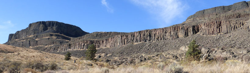
Other notable inselbergs include Spitzkoppe (figure 2) which towers about 600 m (2,000 ft) above the Namib Desert, southwestern Africa.12 This desert is a gravel-capped planation surface in the country of Namibia, west of the Great Escarpment in southern Africa.
The famous Sugarloaf Mountain, 400 m (1,300 ft) tall, and other granite residuals (leftover remnants of erosion) bordering the Rio de Janeiro harbour of Brazil are also inselbergs.

Stone Mountain, Georgia, is one of the most famous ones in the eastern United States.
In the southwestern USA, Monument Valley on the border of Utah and Arizona contains an impressive group of inselbergs. These sedimentary erosional remnants stand about 300 m (1,000 ft) above the wide valley.
An unusual and beautiful type of inselberg that was carved from limestone is called ‘tower karst’. The most impressive examples are found in China (figure 3) and southern Thailand.
Inselbergs cannot be millions of years old
Inselbergs were once buried underground. When the surrounding landscape was eroded away, the more resistant material was left behind in the form of tall towering structures. Interestingly, many inselbergs are weathering relatively quickly today.10,13 By conventional geological reasoning, then, they should have weathered at the same rate as the surrounding countryside, and therefore lost their great height. However, inselbergs are ‘dated’ as many millions to tens of millions of years old; some are even claimed to be older than 100 million years.13 It makes no sense for the surrounding countryside to be eroded down hundreds of metres over millions of years, while the inselberg shows little sign of erosion in all that time.

Such a radical disparity in erosion when millions of years are assumed is dramatically illustrated at Devils Tower, Wyoming, USA. This tall steep-walled igneous body stands some 400 m (1,300 ft) above the nearby river (figure 4).14 Because of its vertical cracks and freeze-thaw weathering, blocks are constantly falling off. It is eroding rapidly, and yet it is claimed to be 40 million years old. Interestingly, the width of Devils Tower has apparently changed very little during all that alleged time,15 even though hundreds of metres of material was eroded from the surrounding landscape. The anomaly is especially blatant since gravity causes vertical faces to erode much faster than horizontal surfaces.
Another example is Navajo Mountain near the Utah/Arizona border. It is about 130 kilometres (80 miles) northeast of Grand Canyon and stands some 3,200 m (10,500 ft) above sea level. Navajo Mountain is a volcanic mass that formed within sedimentary rocks. Today it rises about 1,800 m (6,000 ft) above the surrounding sedimentary rock. If we assume a secular interpretation, it is strange that all of the sedimentary rock surrounding Navajo Mountain was eroded away, but the mountain itself was not.
Mystery for long-age geology
Despite several hypotheses, the origin and supposed long survival of inselbergs is a mystery for the secular interpretation. Geomorphologists Twidale and Bourne state: “That an inselberg could survive for so long as is suggested here calls for considerable mental adjustment.”16 They later said that all hypotheses which attempt to explain the exposure of landforms for tens of millions of years fall short of solving the age problem:
“Various mechanisms and factors have been suggested in explanation of such very old palaeoforms (unequal activity, reinforcement mechanisms, stability of rocks when dry) … but they alleviate rather than resolve the difficulty.”17

Inselbergs—powerful evidence for Flood runoff
It is well known that floods leave behind erosional remnants.18 Steamboat Rock (figure 5) in the upper Grand Coulee is an erosional remnant 275 m (900 ft) tall from the huge Lake Missoula Ice Age flood.19 The Missoula Flood provides further evidence that floods produce inselbergs, and that erosion has to be rapid or there would be no inselbergs.
Just as other floods have left erosional remnants, the runoff of the Genesis Flood has left thousands of inselbergs on the earth’s surface. This phenomenon cannot be explained by slow erosion over millions of years.
References and notes
- Oard, M.J., Massive erosion of continents demonstrates Flood runoff, Creation 35(3):44–47, 2013; creation.com/continental-erosion. Return to text.
- Oard, M.J., Long-distance boulder deposits reveal Noah’s Flood, Creation 38(3):24–27, 2016. Return to text.
- Oard, M.J., Testimony to the Flood; a remarkable planation surface in Canada, Creation 38(4):26–28, 2016. Return to text.
- Oard, M.J., Coastal great escarpments caused by flood runoff, Creation 37(4):46–48, 2015. Return to text.
- The study of the features of the earth’s surface. Return to text.
- Oard, M.J., Flood by Design: Receding Water Shapes the Earth’s Surface, Master Books, Green Forest, AR, 2008. Return to text.
- Twidale, C.R., The evolution of bornhardts, American Scientist 70(3):268–276, 1982. Return to text.
- Neuendorf, K.K.E., Mehl, Jr., J.P., and Jackson, J.A., Glossary of Geology, 5th ed., American Geological Institute, Alexandria, VA, p. 328, 2005. Return to text.
- Snelling, A., The origin of Ayers Rock, Creation 7(1):6–9, 1984; creation.com/ayers-rock. Return to text.
- Twidale, C.R., On the origin of Ayers Rock, Central Australia, Zeitschrift für Geomorphologie N. F. 31:177–206, 1978. Return to text.
- Twidale, Ref. 10, p. 203. Return to text.
- Matmon, A., Mushkin, A., Enzel, Y., Grodek, T., and the ASTER Team, Erosion of a granite inselberg, Gross Spitzkoppe, Namib Desert, Geomorphology 201:52–59, 2013. Return to text.
- Jeje, L.K., Inselberg’s evolution in a humid tropical environment: the example of South Western Nigeria, Zeitschrift für Geomorphologie N. F. 17:194–225, 1973. Return to text.
- Oard, M.J., Devils Tower can be explained by floodwater runoff, J. Creation 23(2):124–127, 2009; creation.com/landscape-erosion. Return to text.
- Závada, P., Dĕdeček, P., Lexa, J., and Keller, G.R., Devils Tower (Wyoming, USA): A lava coulee emplaced into a maar-diatreme volcano? Geosphere 11(2):354–375, 2015. Return to text.
- Twidale, C.R. and J.A. Bourne, Episodic exposure of inselbergs. GSA Bulletin 86:1,480, 1975. Return to text.
- Twidale, C.R. and Bourne, J.A., Origin and age of bornhardts [dome-shaped inselbergs], southwest Western Australia, Australian J. Earth Sciences 45:913, 1998. Return to text.
- Figure 1 in Oard, M.J., Retreating Stage formation of gravel sheets in south-central Asia, J. Creation 25(3):68–73, 2011 (creation.com/south-asia-erosion) shows erosional remnants left in a field after erosion by a flood. Return to text.
- Oard, M.J., DVD: The Great Missoula Flood: Modern Day Evidence for the Worldwide Flood, Awesome Science Media, Canby, OR, 2014. Return to text.


Readers’ comments
Comments are automatically closed 14 days after publication.